Related Research Articles

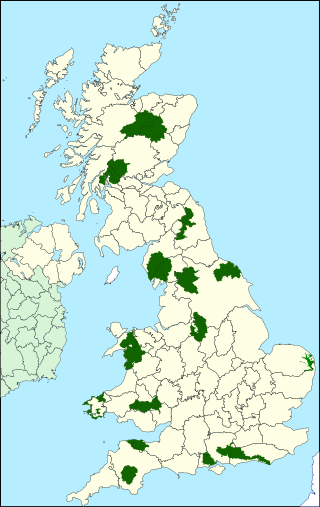
A site of special scientific interest (SSSI) in Great Britain, or an area of special scientific interest (ASSI) in the Isle of Man and Northern Ireland, is a conservation designation denoting a protected area in the United Kingdom and Isle of Man. SSSI/ASSIs are the basic building block of site-based nature conservation legislation and most other legal nature/geological conservation designations in the United Kingdom are based upon them, including national nature reserves, Ramsar sites, Special Protection Areas, and Special Areas of Conservation. The acronym "SSSI" is often pronounced "triple-S I".
Protected areas of the United Kingdom are areas in the United Kingdom which need and /or receive protection because of their environmental, historical or cultural value to the nation. Methods and aims of protection vary depending on the nature and importance of the resource. Protection operates at local, regional, national and international levels, and may be backed by legislation and international treaty, or less formally by planning policy.

Bracknell Forest is a unitary authority area in Berkshire, southern England. It covers the two towns of Bracknell and Sandhurst and the village of Crowthorne and also includes the areas of North Ascot, Binfield, Warfield, and Winkfield. The borough borders Wokingham and the Royal Borough of Windsor & Maidenhead in Berkshire, and also parts of Surrey and Hampshire.

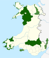
National nature reserves in Wales are selected and designated by Natural Resources Wales (NRW). There are 76 reserves all of which are also SSSIs, they cover 26,536 hectares (265.36 km2), or less than 1.5% of the land area of Wales. They range in size from Dan yr Ogof at 0.5 hectares (5,000 m2) to Berwyn which covers 7,920 hectares (79.2 km2). A national nature reserve is designated because of its special biological, geological, habitat or landscape value and most in Wales are open to the public. They include upland and lowland areas, several offshore islands and in some cases estuarine and intertidal zones.
National parks of the United Kingdom are areas of relatively undeveloped and scenic landscape across the country. Despite their name, they are quite different from national parks in many other countries, which are usually owned and managed by governments as protected community resources, and which do not usually include permanent human communities. In the United Kingdom, an area designated as a national park may include substantial settlements and human land uses that are often integral parts of the landscape. Land within national parks remains largely in private ownership. These parks are therefore not "national parks" according to the internationally accepted standard of the IUCN but they are areas of outstanding landscape where planning controls are a little more restrictive than elsewhere.
Local nature reserve (LNR) is a statutory designation for certain nature reserves in Great Britain. The Wild Life Conservation Special Committee established them and proposed a national suite of protected areas comprising national nature reserves, conservation areas, national parks, geological monuments, local nature reserves and local educational nature reserves.

Teesdale is a dale, or valley, located principally in County Durham, North East England. It is one of the Durham Dales, which are themselves part of the North Pennines, the northernmost part of the Pennine uplands.

Heathfield and Waldron is a civil parish within the Wealden District of East Sussex, England. Heathfield is surrounded by the High Weald Area of Outstanding Natural Beauty. The parish was formed on 1 April 1999 from "Heathfield" and "Waldron" parishes.
Site of Nature Conservation Interest (SNCI), Site of Importance for Nature Conservation (SINC) and regionally important geological site (RIGS) are designations used by local authorities in the United Kingdom for sites of substantive local nature conservation and geological value. The Department for Environment, Food and Rural Affairs has recommended the generic term 'local site', which is divided into 'local wildlife site' and 'local geological site'.
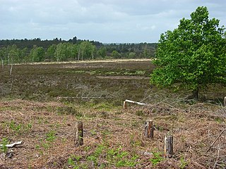
Woolmer Forest is a 1,298.5-hectare (3,209-acre) biological Site of Special Scientific Interest south of Bordon in Hampshire and West Sussex. It is also a Special Area of Conservation and part of the Wealden Heaths Phase II Special Protection Area. Two areas are Nature Conservation Review sites, Grade I.

Wales, a country that is part of the United Kingdom, contains protected areas under various designations. The largest designation by land area is Wales' three national parks, followed by the five Areas of Outstanding Natural Beauty.

Clemenstone or Clemenston is a hamlet located in the western part of the Vale of Glamorgan, southeast Wales, southeast of Bridgend. Historically part of Glamorgan, it contains the Clemenstone Estate and House, long-time seat of the Curre family, and a Sports Academy. Clemenstone Meadows are a Site of Special Scientific Interest (SSSI).

Many parts of Scotland are protected in accordance with a number of national and international designations because of their environmental, historical or cultural value. Protected areas can be divided according to the type of resource which each seeks to protect. NatureScot has various roles in the delivery of many environmental designations in Scotland, i.e. those aimed at protecting flora and fauna, scenic qualities and geological features. Historic Environment Scotland is responsible for designations that protect sites of historic and cultural importance. Some international designations, such as World Heritage Sites, can cover both categories of site.
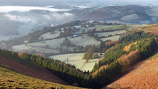
The Clwydian Range and Dee Valley is a designated Area of Outstanding Natural Beauty (AONB) located in north-east Wales, covering the Clwydian Range, and the valley of the River Dee.
References
- ↑ http://lle.gov.wales/map#m=-3.159,51.47832,8&b=europa&l=1356; Welsh Government mapping portal
| National parks |
|  | ||
|---|---|---|---|---|
| Areas of Outstanding Natural Beauty |
| |||
| Heritage coasts | ||||
| Nature reserves | ||||
| Site of Special Scientific Interest | ||||
| European designations (–2020) | ||||
| Other designations | ||||