

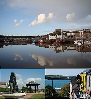
Porthclais (also known as Porth Clais) is a small sheltered inlet harbour near St Davids, Pembrokeshire, Wales, in the community of St Davids and the Cathedral Close.
Porthclais (also known as Porth Clais) is a small sheltered inlet harbour near St Davids, Pembrokeshire, Wales, in the community of St Davids and the Cathedral Close.
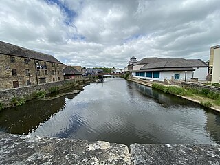
Porthclais harbour was built in the 12th century, importing coal and timber. The entire harbour is within the St David's Peninsula Site of Special Scientific Interest. [1] Porthclais is still used as a small port by local fishermen and recreational sailors. The largely intact old harbour wall may have been built by the Romans, and the harbour was mentioned in the mediaeval Mabinogion. The earliest recorded date of trade through the port is 1385. [2] [3]
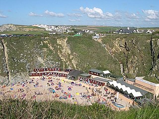
The harbour dries out at low tide and is a good launching spot for small boats, dive craft and kayaks who are setting out to explore St Bride's Bay. Porthclais harbour has some of the best preserved remains of stone Lime kilns in Pembrokeshire. [4]
Porthclais Harbour Authority Limited provides harbour services; [5] the harbour can accommodate around 50 small boats and is very busy at peak times. [6]
There is a car park on the site of what used to be the now defunct St. Davids gasworks, which in turn was built on the site of a spring where it is said St. David himself was baptised.

Pembrokeshire is a county in the south-west of Wales. It is bordered by Carmarthenshire to the east, Ceredigion to the northeast, and otherwise by the sea. Haverfordwest is the largest town and administrative headquarters of Pembrokeshire County Council.

Goodwick is a coastal town in Pembrokeshire, Wales, immediately west of its twin town of Fishguard.

Pembrokeshire Coast National Park is a national park along the Pembrokeshire coast in west Wales.

Ramsey Island is an island about 1 kilometre off St David's Head in Pembrokeshire on the northern side of St Brides Bay, in southwest Wales, in the community of St Davids and the Cathedral Close. It is 259 hectares in area. Ramsey means Hrafn's island.
Milford Haven is both a town and a community in Pembrokeshire, Wales. It is situated on the north side of the Milford Haven Waterway, an estuary forming a natural harbour that has been used as a port since the Middle Ages.

Burry Port is a port town and community in Carmarthenshire, Wales, on the Loughor estuary, to the west of Llanelli and south-east of Kidwelly. Its population was recorded at 5,680 in the 2001 census and 6,156 in the 2011 census, and estimated at 5,998 in 2019. The town has a harbour. It is also where Amelia Earhart landed as the first woman to fly across the Atlantic Ocean. Nearby are the Pembrey Burrows sand dune and wetland system, forming a country park, and the Cefn Sidan sands. Its musical heritage includes Burry Port Opera, Male Choir and Burry Port Town Band.

Pembroke Dock is a town and a community in Pembrokeshire, South West Wales, 3 miles (4.8 km) northwest of Pembroke on the banks of the River Cleddau. Originally Paterchurch, a small fishing village, Pembroke Dock town expanded rapidly following the construction of the Royal Navy Dockyard in 1814. The Cleddau Bridge links Pembroke Dock with Neyland.
St Columb Canal sometimes referred to as Edyvean's Canal, was an abortive canal scheme in Cornwall, England, designed for the carriage of sea sand for use as manure. It was authorised in 1773, and part of it may have been briefly used around 1780.

Porthgain is a hamlet in the Pembrokeshire Coast National Park in Wales, located between St David's and Goodwick just west of the village of Llanrhian, and in the parish of the same name.

Milford Haven Waterway is a natural harbour in Pembrokeshire, Wales. It is a ria or drowned valley which was flooded at the end of the last ice age. The Daugleddau estuary winds west to the sea. As one of the deepest natural harbours in the world, it is a busy shipping channel, trafficked by ferries from Pembroke Dock to Ireland, oil tankers and pleasure craft. Admiral Horatio Nelson, visiting the haven with the Hamiltons, described it as the next best natural harbour to Trincomalee in Ceylon and "the finest port in Christendom". Much of the coastline of the Waterway is designated as a Site of Special Scientific Interest, listed as Milford Haven Waterway SSSI.
The River Cleddau consists of the Eastern and Western Cleddau rivers in Pembrokeshire, west Wales. They unite to form the Daugleddau estuary and the important harbour of Milford Haven.

Porth is a seaside hamlet in the civil parish of Newquay, Cornwall, England.

Whitesands Bay is a Blue Flag beach situated on the St David's peninsula in the Pembrokeshire Coast National Park, Wales. Whitesand Bay, on some maps, located 2 miles (3.2 km) west of St. Davids and 1 mile (1.6 km) south of St Davids Head, has been described as the best surfing beach in Pembrokeshire.

St Elvis is a parish in Pembrokeshire, Wales, about 4 miles (6 km) east of St David's. At 200 acres (81 ha) it is one of the smallest parishes in Wales but its rector was previously the superior of the vicar of the church at Solva. The parish of Whitchurch and St Elvis together form the community of Solva.

The Chapel of St Non is located on the coast near St David's in Pembrokeshire, West Wales. Held by tradition to mark the birthplace of St David, the ruin cannot be accurately dated but is unusual in that it is aligned north–south rather than the usual east–west. Near to the ruined chapel is a retreat, a modern chapel and a holy well. The site was protected in the 1950s and is now the responsibility of the Welsh Heritage organisation Cadw.

Fishing in Cornwall, England, UK, has traditionally been one of the main elements of the economy of the county. Pilchard fishing and processing was a thriving industry in Cornwall from around 1750 to around 1880, after which it went into an almost terminal decline. During the 20th century the varieties of fish taken became much more diverse and crustaceans such as crab and lobster are now significant. Much of the catch is exported to France due to the higher prices obtainable there. Though fishing has been significantly damaged by overfishing, the Southwest Handline Fishermen's Association has started to revive the fishing industry. As of 2007, stocks were improving. The Cornwall Sea Fisheries Committee is one of 12 committees responsible for managing the corresponding Sea Fisheries District. The Isles of Scilly Sea Fisheries Committee is responsible for the Scilly district.

The River Alun is a small river in northwest Pembrokeshire, Wales, which rises near Tretio Common and flows southwestwards to St Davids to empty into St Bride's Bay at the rocky inlet of Porth Clais.

St Justinian is a coastal location of indeterminate area in the extreme northwest of Pembrokeshire, Wales, in the community of St Davids and the Cathedral Close.
51°52′05″N5°16′48″W / 51.868°N 5.280°W