Map all coordinates usingOpenStreetMapDownload coordinates asKML
There are around 1,000 listed buildings in Cardiff,[1] the capital city of Wales. A listed building is one considered to be of special architectural, historical or cultural significance, which is protected from being demolished, extended or altered, unless special permission is granted by the relevant planning authorities. The Welsh Government makes decisions on individual cases, taking advice from the heritage agency Cadw, the Royal Commission on the Ancient and Historical Monuments of Wales and local councils.[2]
Buildings of exceptional, usually national, interest (generally the top 2 per cent).
GradeII*
Particularly important buildings of more than special interest.
GradeII
Buildings of special interest, which warrant every effort being made to preserve them.
Because of the way in which buildings are listed and the large number of listed buildings within the city, they have been subdivided into Grade I, II* and II buildings, with the Grade II buildings being further split up by area.
Designed by William Burges and constructed after his death by his assistant, William Frame.[4] The Wall was moved from the front of Cardiff Castle to its current location in 1922.
Built on the foundations of a Roman fort (a small part of the Roman wall of white bricks remains visible at the south-east corner) the above ground construction mostly dates from the Norman period to the late 19th century. A Motte was built by Robert Fitzhamon in 1081 followed by a stone Bailey in the 12th century. Gilbert de Clare built the Black Tower at the south entrance during the 13th century. Much of the remaining castle and walls were constructed or redecorated by the Earls and Marquises of Bute between 1778 and the 1890s in a fantasy gothic style.[6]
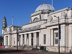
A Beaux-Arts design by the architects Arnold Dunbar Smith and Cecil Brewer. The building as it stands is a truncated version of a scheme they proposed in 1910; the west wing largely following the original design was built in 1962–65 by T. Alwyn Lloyd & Gordon. The remaining space was filled in 1993 by the Alex Gordon Partnership.[13]
An impressive gatehouse and courtyard (now a garden) remains. The Palace was possibly built during the time of Bishop William de Braose. It has similarities to the contemporary Caerphilly Castle.[18]
Designed by John Prichard at the behest of the Third Marquess of Bute, this church replaced an ancient chapel on the same site. It includes the Marquess's family mausoleum.[25]
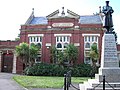
Designed by architects James, Seward & Thomas, the building became the Central Library in 1896. Includes stained glass throughout and an entrance hall decorated with tiles.
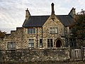
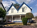
The main building was built as Llandaff Court, the seat of Admiral Thomas Mathews, on the site of the ancient manor house of Bryn-y-Gynnon. Its architect was probably John Wood, who was engaged on the restoration of Llandaff Cathedral at the time of the house's construction.[72]
Designed by Alexander Roos to the west of Cardiff Castle as a decorative gatehouse to the estate of the Marquess of Bute. Converted into tea-rooms in 2012, retaining the original Victorian floor tiles.[79]
Built in 1960 to designs by F. R. Bates Son and Price, exterior features a concrete sculpture by Adam Kossowski of St. Francis's vision of Christ on the Cross.
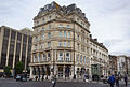
A generous two-storey public house with a four-storey tower, on a prominent corner of Canton. Dating from 1889 and built on Cardiff Corporation land, hence the name.[81]
A Roman Catholic church designed by Frederick Walters, with the tower added in 1916. Listed as "a very good Roman Catholic church designed by a notable Edwardian architect".[83]
Two-storey five-bay building, originally sited next to the Glamorganshire Canal. Listed for its importance to Cardiff's commercial history.[91] Demolished by developers in early 2019, with only the facade wall retained.
Great Western Railway water tower, 15 metres in height, built in concrete with a fluted base.[86] In 1984 it was embellished with a painted design of giant daffodils.[93] It was repainted in cream and beige, the colours of the GWR, in 2012.[86]
Completed in the 1930s, designed in the Byzantine style in rich brown brick. The church was designed by T. Roderick of Aberdare and provided at a cost of £10,000 by Lord Glanely in memory of his wife, Ada. Design inspired by the Community of the Resurrection in Mirfield, West Yorkshire, by Walter Tapper.[94]
A cast-iron Gothic stylemile post dating from 1835. One of a number of mileposts to the west of Cardiff on the A48. Inscribed 'LANDAFF PARISH' on a rectangular panel, with 'CARDIFF DISTRICT' inscribed on the top. Left hand panel inscribed 'TO CARDIFF 3', right hand side inscribed 'TO COWBRIDGE 9'. 'LONDON 161' inscribed at base.
A cast-iron Gothic stylemile post dating from 1835. One of a number of mileposts to the west of Cardiff on the A48. Inscribed 'MICHAELSTONE PARISH' on a rectangular panel, with 'CARDIFF DISTRICT' inscribed on the top. Left hand panel inscribed 'TO CARDIFF 4', right hand side inscribed 'TO COWBRIDGE 8'. 'LONDON 162' inscribed at base.
Included as an unaltered design by Ewan Christian and for its group value with the other listed buildings around The Cathedral Green and on the High Street.
Included as a largely 18th-century house and for its group value with the other listed buildings around The Cathedral Green and on the High Street. Now in commercial use as a teahouse
Pillar box erected at the same period as the houses of the garden village; inscribed with the monogram of King George V and its manufacturer, the Carron Company of Stirlingshire.
Small single storey building, originally used as offices. Plaques record the Rhiwbina Garden Village Conservation Area and the Rhiwbina Garden Village Residents Association.
A former mental hospital. The hospital chapel and six octagonal shelters in the grounds are separately listed as Grade II.[127][128][126][129][130][131][132][133]
↑ "Cardiff Castle and Bute Park". Coflein. Royal Commission on the Ancient and Historical Monuments of Wales. Archived from the original on 21 February 2014. Retrieved 17 March 2013.
This page is based on this Wikipedia article Text is available under the CC BY-SA 4.0 license; additional terms may apply. Images, videos and audio are available under their respective licenses.