Heath, Cardiff

Last updated

Heath
Community
Entrance to Heath Park, Cardiff - geograph.org.uk - 1746088.jpg
Entrance to Heath Park
Cardiff UK location map.svg
Red pog.svg
Heath
Location within Cardiff
Principal area
Country Wales
Sovereign state United Kingdom
Police South Wales
Fire South Wales
Ambulance Welsh
List of places
UK
Wales
Cardiff

51°30′40″N3°11′56″W / 51.511°N 3.199°W / 51.511; -3.199

Contents

2024 Wales Cardiff Community Heath map.svg
Cew heath.jpg

Heath (Welsh : Y Mynydd Bychan) is a district, community and coterminous electoral ward in the north of Cardiff, capital of Wales. It is a predominantly affluent area with property prices being the third highest in the city. The area is known for its traditional 1930s detached and semi-detached properties with large south facing gardens. Roads are tree lined and large greeneries with the notable attraction of Heath Park and the joining of the University Hospital of Wales.

The population of the ward and community taken at the 2011 census was 12,629. [1]

Description

Heath was originally called the Great Heath and named as a result of the large park and woodland that it once contained. After the initial development of traditionally middle-classed semi-detached housing (1920s-1950s) and more recently the construction of the University Hospital of Wales on the site of the former Heath Wood (1960s), much of the greenery has been eradicated. [2] It should be distinguished from the Little Heath (Welsh : Y Waun Ddyfal) which lies to the south of the Great Heath, in the vicinity of Crwys Road.

The 91 acre, (37 hectare) Heath Park [3] forms the remainder of this area of grass and woodland. It includes attractions and facilities such as the George V Playing Fields, tennis courts, a miniature steam railway and refreshment facilities. [4]

Birchgrove is a busy shopping area that is part of the ward of Heath. It is composed mostly of more affordably priced housing, mainly terraced, and has taken on an identity of its own.

The area around the University Hospital of Wales has been known as Saints Corner, due to the number of streets in the area named after well known saints.

The Welsh language

The number of Heath residents over three years old who speak Welsh increased from 1,378 in the 2001 UK Census to 1,422 in the 2011 UK Census. In percentage terms there was a slight decrease (from 12.1% to 11.7%). This was caused by a reduction in the number of speakers over the age of 65; the age groups 3–15 and 16—64 both showed increases. [5]

Transport

Heath Low Level station Heath Low Level Up.jpg
Heath Low Level station

Rail

The area is served by two railway stations. Heath Low Level is on the Coryton Line, linking Central and Coryton stations. Heath High Level is on the Rhymney Line, linking Central and Rhymney stations via Llanishen, Lisvane Thornhill and Caerphilly.

Bus

Cardiff Bus's routes 38 and 39 terminate at the University Hospital of Wales, originating from the City Centre. The 8 now operates between the City Centre and Grangetown, while the 9/9A operates from the City Centre to IKEA and Cardiff Bay, including the Sports Village. The 86 service runs to Lisvane via Heath. The following services run through west of Heath:

Walking and cycling

Cardiff Council have recently implemented a number of traffic calming measures [6] on Allensbank Road / Heath Park Avenue with the aim of slowing traffic on the major thoroughfare and improving safety for pedestrians. The council also has plans for Cycleway 1 to run through the area, [7] continuing on from Gabalfa to the neighbouring ward of Cyncoed.

Governance

Westminster: As part of Cardiff North, Heath has been represented at Westminster since 2017 by Anna McMorrin MP (Welsh Labour)

Senedd: As part of Cardiff North, Heath has been represented in the Senedd since 2011 by Julie Morgan, MS (Labour)

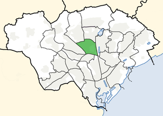
Location of Heath electoral ward in Cardiff Cew heath.jpg
Location of Heath electoral ward in Cardiff

Heath is both an electoral ward, and a community of the City of Cardiff. There is no community council for the area.

The electoral ward of Heath falls within the parliamentary constituency of Cardiff North. It is bounded by Rhiwbina and Llanishen to the north; Cyncoed to the east; Gabalfa and Cathays to the south; Llandaff North to the southwest; and Whitchurch & Tongwynlais to the west.

Cardiff Council: Since May 2017 Heath is represented on Cardiff Council by three councillors, Lyn Hudson (Conservative), Graham Hinchey (Welsh Labour) and Fenella Bowden (Heath & Birchgrove Independents). [8] Cllr Bowden had been a member of the Liberal Democrats but left, to sit as an Independent councillor, in November 2010. [9] In the past it has been represented by a variety of political groups, moving from Labour in the 1990s, to all Liberal Democrat in May 2004 and, after the May 2008 election, a Conservative majority. [10]

Related Research Articles

<span class="mw-page-title-main">Rhiwbina</span> Suburb and community of Cardiff, Wales

Rhiwbina is a suburb and community in the north of Cardiff, the capital of Wales. Formerly a small hamlet within the parish of Whitchurch, Rhiwbina was developed throughout the twentieth century, and is now a separate ward. It retains aspects of its former character, however, and is given a Welsh village appearance by Beulah United Reformed Church at the village crossroads.

<span class="mw-page-title-main">Llanishen</span> District and community in Cardiff, Wales

Llanishen is a district and community in the north of Cardiff, Wales. Its population as of the 2011 census was 17,417.

<span class="mw-page-title-main">Cathays</span> District and community in Cardiff, Wales

Cathays is a district and community in the centre of Cardiff, capital of Wales. It is an old suburb of Cardiff established in 1875. It is densely populated and contains many Victorian terraced houses. The area falls into the Cathays ward. It is the third most populous community in Cardiff, having a population of 18,002 in 2011.
<span class="mw-page-title-main">Lisvane</span> Community in Cardiff, Wales

Lisvane is a community in the north of Cardiff, the capital of Wales, located 5 miles (8 km) north of the city centre. Lisvane is generally considered to be one of the wealthiest residential areas of Wales, with many properties worth in excess of £1 million. Lisvane had 3,319 residents in 2001 and comprises approximately 1,700 dwellings, a local village shop, primary school, community cabin library, park, nursery, parish church, public house, war memorial, Scout hall and community or village hall.

<span class="mw-page-title-main">Gabalfa</span> District and community of Cardiff, Wales

Gabalfa is a district and community in the north of the city of Cardiff, capital of Wales. It is characterised by a four-lane flyover road at the Gabalfa Interchange, where the A48 road meets the A470 road which leads from Cardiff to northern Wales, and the A469 road.

<span class="mw-page-title-main">Cyncoed</span> Community in Cardiff, Wales

Cyncoed is a community in the northeast of Cardiff, the capital of Wales. With many properties in the area fetching over £1 million, Cyncoed is considered to have some of the highest property prices in the country. Cyncoed overlooks the city centre of Cardiff, near Roath Park, with views of the surrounding mountains.

<span class="mw-page-title-main">Cardiff North (UK Parliament constituency)</span> Parliamentary constituency in the United Kingdom, 1950 onwards

Cardiff North is a constituency represented in the House of Commons of the UK Parliament since 2017 by Anna McMorrin of the Labour Party.
<span class="mw-page-title-main">Birchgrove, Cardiff</span> District of Cardiff, Wales

Birchgrove is a district of the city of Cardiff stretching between Llanishen and the Gabalfa interchange, along the A469 Caerphilly road.

<span class="mw-page-title-main">Llandaff North</span> District and community of Cardiff, Wales

Llandaff North, is a district, community and coterminous electoral ward in the north of Cardiff, the capital city of Wales.
<span class="mw-page-title-main">Pontprennau</span> Community in Cardiff, Wales

Pontprennau is a ward and community in the north of the city of Cardiff, Wales, lying north of Pentwyn and Cyncoed, between the village of Old St Mellons and the farmlands east of Lisvane. The community had a population of 7,353 in 2011.
<span class="mw-page-title-main">Llanishen (electoral ward)</span> Community/Electoral ward in Wales

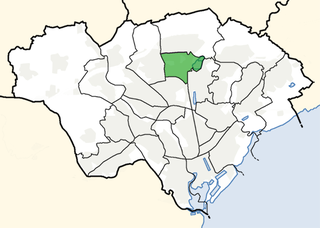
Llanishen is the name of an electoral ward in the north of Cardiff, capital city of Wales. It covers the community of Llanishen.

<span class="mw-page-title-main">Rhiwbina (electoral ward)</span> Community/Electoral ward in Wales

Rhiwbina is the name of an electoral ward in the north of Cardiff, capital city of Wales. It covers the community of the same name.
<span class="mw-page-title-main">Heath (Cardiff ward)</span> Electoral ward in Wales

Heath is the name of an electoral ward in the north of the city of Cardiff, Wales, which covers its namesake community, Heath. The ward elects three county councillors to the County Council of the City and County of Cardiff.

<span class="mw-page-title-main">Cardiff Rural District</span> Local government district in Wales

Cardiff Rural District was a second tier local government district of Glamorgan, Wales, until 1974. It covered the more rural areas to the west and north of the city of Cardiff.

The 1983 Cardiff City Council election was held on Thursday 5 May 1983 to the district council known as Cardiff City Council, in Cardiff, South Glamorgan, Wales. It took place on the same day as other district council elections in Wales and England. The Conservative Party regained control of the council from the Labour Party.

<span class="mw-page-title-main">2022 Cardiff Council election</span> Local election in Wales

The 2022 Cardiff Council election took place on 5 May 2022 to elect 79 members to Cardiff Council. On the same day, elections were held to the other 21 local authorities and to community councils in Wales as part of the 2022 Welsh local elections.

References

  1. "Ward population 2011" . Retrieved 8 April 2015.
  2. "The history of the suburb of Heath - Cardiffians.co.uk". www.cardiffians.co.uk. Retrieved 22 August 2019.
  3. "Heath Park". Cardiff Council. Retrieved 1 March 2019.
  4. "Heath Park - History". CardiffParks.org.uk. Retrieved 1 March 2019.
  5. 'Welsh Language Commissioner: 2011 Census results by Community Archived 2013-10-22 at the Wayback Machine .
  6. "Allensbank Road / Heath Park Avenue - Road Safety Improvements" (PDF). 21 August 2019. Retrieved 21 August 2019.
  7. "Cycleways Map" (PDF). Cycleways. Retrieved 22 August 2019.
  8. "Election results for Heath - Cardiff Council Elections 2017 - Thursday, 4th May, 2017". Cardiff Council. Retrieved 21 March 2018.
  9. "Heath councillor leaves Lib Dem group". theguardian.com. 18 November 2010. Retrieved 20 April 2018.
  10. "Cardiff Council Election Results 1995-2012" (PDF). The Elections Centre. Retrieved 21 March 2018.