
Coryton is a district of Cardiff, the capital city of Wales, lying immediately to the north of Whitchurch next to junction 32 of the M4 motorway. It is within the Whitchurch & Tongwynlais electoral ward.
Coryton is a district of Cardiff, the capital city of Wales, lying immediately to the north of Whitchurch next to junction 32 of the M4 motorway. It is within the Whitchurch & Tongwynlais electoral ward.
Coryton House is a large Edwardian house built in 1900 for the shipowner and dry-dock owner John Cory (1855–1931), the founder of the shipping company John Cory and Sons and the father of the politician Sir Herbert Cory, 1st Baronet (1857–1933), who also lived in Coryton House. [1] The gardens of Coryton House were expanded in the interwar period and are listed as Grade II on the Cadw/ICOMOS Register of Parks and Gardens of Special Historic Interest in Wales. [2] After Sir Herbert's death in 1933 the house became the civil defence headquarters for Cardiff. Offices were built on the part of the garden between the house and Pendwyallt Road, now replaced by housing, and the Village Hotel was built on the kitchen gardens. [3] [4] Coryton House is now Ty Coryton, a special school specialising in children with autism. [5]
This section needs additional citations for verification .(March 2020) |
The district contains a mix of early and mid-20th century suburban housing estates, 1960s council housing and some post-2000 developments.

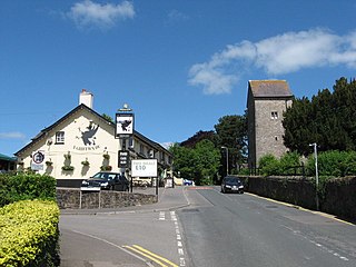
Due to the area's close proximity to Whitchurch, it has few amenities of its own. To visitors, it is probably best known for The Hollybush public house, the Village Hotel at the M4 motorway junction, and the biggest Asda supermarket in South Wales.
The Glamorganshire Canal local nature reserve, a country park, is adjacent to the River Taff.
The area is served by Coryton railway station, the terminus of the Coryton Line.
Inter Coryton football club plays its home games in nearby Caedelyn Park. [6]

The M4, originally the London-South Wales Motorway, is a motorway in the United Kingdom running from west London to southwest Wales. The English section to the Severn Bridge was constructed between 1961 and 1971; the Welsh element was largely complete by 1980, though a non-motorway section around Briton Ferry bridge remained until 1993. On the opening of the Second Severn Crossing in 1996, the M4 was rerouted over it.

Rhiwbina is a suburb and community in the north of Cardiff, the capital of Wales. Formerly a small hamlet within the parish of Whitchurch, Rhiwbina was developed throughout the twentieth century, and is now a separate ward. It retains aspects of its former character, however, and is given a Welsh village appearance by Beulah United Reformed Church at the village crossroads.

Llanishen is a district and community in the north of Cardiff, Wales. Its population as of the 2011 census was 17,417.
Lisvane is a community in the north of Cardiff, the capital of Wales, located 5 miles (8 km) north of the city centre. Lisvane is generally considered to be one of the wealthiest residential areas of Wales, with many properties worth in excess of £1 million. Lisvane had 3,319 residents in 2001 and comprises approximately 1,700 dwellings, a local village shop, primary school, community cabin library, park, nursery, parish church, public house, war memorial, Scout hall and community or village hall.

Radyr is an outer suburb of Cardiff, about 4 miles (6.4 km) northwest of Cardiff city centre. Radyr is part of Radyr and Morganstown Community, for which the 2011 Census recorded a population of 6,417.
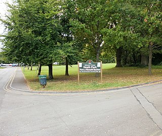
Heath is a district, community and coterminous electoral ward in the north of Cardiff, capital of Wales. It is a predominantly affluent area with property prices being the third highest in the city. The area is known for its traditional 1930s detached and semi-detached properties with large south facing gardens. Roads are tree lined and large greeneries with the notable attraction of Heath Park and the joining of the University Hospital of Wales.

Whitchurch is a suburb and community in the north of Cardiff, capital of Wales. It is approximately 3 miles north of the centre of the city on the A470 road and A4054 road. It falls within the Whitchurch & Tongwynlais ward. The population of the community in 2011 was 14,267.

Pentyrch is a village and community located on the western outskirts of Cardiff, the capital city of Wales. The village gives its name to a Cardiff local authority electoral ward, Pentyrch, which covers the village and immediate surrounding area. The Pentyrch community includes the neighbouring village of Creigiau and Gwaelod y Garth. People living in Pentyrch are commonly known as "Penterchyians".

Pyle is a village and community in Bridgend county borough, Wales. This large village is served by the A48 road, and lies less than one mile from Junction 37 of the M4 motorway, and is therefore only a half-hour journey from the capital city of Wales, Cardiff. The nearest town is the seaside resort of Porthcawl. Within the Community, to the northeast of Pyle, is the adjoining settlement of Kenfig Hill, North Cornelly also adjoins Pyle and the built-up area had a population of 13,701 in 2011.

Tongwynlais is a village and community in the north of Cardiff, Wales, north of the M4 motorway in the Taff Valley. It is notable as the location of the hillside landmark, Castell Coch. The population as of the 2011 census was 1871.

Llandaff North, is a district, community and coterminous electoral ward in the north of Cardiff, the capital city of Wales.
Pontprennau is a ward and community in the north of the city of Cardiff, Wales, lying north of Pentwyn and Cyncoed, between the village of Old St Mellons and the farmlands east of Lisvane. The community had a population of 7,353 in 2011.

The A4119 links Tonypandy with Cardiff in South Wales.
Sir James Herbert Cory, 1st Baronet was a Welsh politician and ship-owner.

Brynglas is an area of the city of Newport, South Wales, United Kingdom.
Cardiff Gate is a business park development, located on the junction 30 of the M4 motorway and the A4232 north east of Cardiff, South Wales.

There are around 1,000 listed buildings in Cardiff, the capital city of Wales. A listed building is one considered to be of special architectural, historical or cultural significance, which is protected from being demolished, extended or altered, unless special permission is granted by the relevant planning authorities. The Welsh Government makes decisions on individual cases, taking advice from the heritage agency Cadw, the Royal Commission on the Ancient and Historical Monuments of Wales and local councils.
Wydham Park is an uncompleted planned village in Peterston-super-Ely in the Vale of Glamorgan. It was the first garden suburb in Wales.

The City and County of Cardiff is a county in the south of Wales. It covers an area of 140.3 km2 (54.2 sq mi) and in 2023 the population was approximately 359,512. Cardiff is the country's capital and hosts its parliament, the Senedd, and a large number of national institutions such as the Wales Millennium Centre, the National Museum, the national stadium of Wales and the St Fagans National Museum of History.
51°31′24″N3°14′01″W / 51.52333°N 3.23361°W
| | This Cardiff location article is a stub. You can help Wikipedia by expanding it. |
