In the United Kingdom, the term listed building refers to a building or other structure officially designated as being of special architectural, historical, or cultural significance; Grade II* structures are those considered to be "particularly important buildings of more than special interest". [1] Listing was begun by a provision in the Town and Country Planning Act 1947. Once listed, strict limitations are imposed on the modifications allowed to a building's structure or fittings. In Wales, the authority for listing under the Planning (Listed Buildings and Conservation Areas) Act 1990 [2] rests with Cadw.
Name | Location Grid Ref. [note 1] Geo-coordinates | Date Listed | Function | Notes | Reference Number | Image |
---|---|---|---|---|---|---|
Church of St James | Wick SS9233072180 51°26′18″N3°33′02″W / 51.43837°N 3.55046°W | 26 July 1963 | Church | Located on the N side of Church Street in the centre of Wick Village. Located in a roughly rectangular churchyard. | 11221 | |
Church of St Bridget | St Brides Major SS8941375010 51°27′48″N3°35′36″W / 51.46324°N 3.59329°W | 26 July 1963 | Church | Set within a polygonal churchyard on the hillside, towards the NW end of St. Brides Major. | 11226 | |
Ewenny Priory (house) | Ewenny SS9124677776 51°29′18″N3°34′04″W / 51.48846°N 3.56777°W | 26 July 1963 | Church | About 1km northeast of Ewenny village, a five-bay Georgian mansion to south of Ewenny Priory. | 11249 | |
Flemingston Court Farmhouse | St Athan ST0169370023 51°25′14″N3°24′55″W / 51.42069°N 3.41520°W | 16 December 1952 | Farmhouse | On the south side of the Churchyard of the Church of St Michael the Archangel. | 13130 | Upload Photo |
Gileston Manor | Gileston (St Athan) ST0176667072 51°23′39″N3°24′48″W / 51.39417°N 3.41333°W | 16 December 1952 | House | In the centre of Gileston village and immediately west of the Church of St Giles. | 13131 | |
Great House (Ty Mawr), Aberthin | Aberthin ST0107875288 51°28′04″N3°25′32″W / 51.46791°N 3.42551°W | 16 December 1952 | House | In large walled garden about 300m E of centre of Aberthin; on N side of Nant Aberthin. | 13132 | |
Llanmaes House | Llan Maes SS9812569487 51°24′55″N3°27′59″W / 51.41524°N 3.46634°W | 16 December 1952 | House | In the centre of Llanmaes village facing the east end of the Church of St. Cattwg. | 13134 | |
Castleton Farmhouse | St Athan ST0240668376 51°24′22″N3°24′16″W / 51.40601°N 3.40449°W | 16 December 1952 | Farmhouse | About 700m north-east of the Church of St. Athan and approached down a cul-de-sac. | 13140 | Upload Photo |
Parish church of St Michael and All Angels, Llanmihangel | Llanmihangel, Llandow SS9813571886 51°26′12″N3°28′01″W / 51.436805°N 3.466887°W | 22 February 1963 | Church | 13141 | ||
Church of St Brise | St Athan ST0056269124 51°24′45″N3°25′52″W / 51.41241°N 3.43121°W | 22 February 1963 | Church | It is within the boundary fence of RAF St Athan on the south side of a right-angled bend in the road and hidden by trees. | 13142 | Upload Photo |
Church of St Giles | Gileston (St Athan) ST0178767081 51°23′39″N3°24′47″W / 51.39426°N 3.41303°W | 22 February 1963 | Church | In the centre of Gileston village and immediately to the east of Gileston Manor. | 13143 | |
St Quintin's Castle (Llanblethian Castle) | Cowbridge with Llanblethian SS9891074177 51°27′27″N3°27′23″W / 51.45754°N 3.45639°W | 22 February 1963 | Castle | About 450m NE of Llanblethian church on spur of land above loop in River Thaw. | 13146 | |
Holy Trinity Church | Llandow SS9423073322 51°26′56″N3°31′24″W / 51.44899°N 3.52347°W | 22 February 1963 | Church | 13148 | ||
Church Farmhouse (also known as The Glebe) | Llandow SS9422673353 51°26′57″N3°31′25″W / 51.44927°N 3.52354°W | 22 February 1963 | Farmhouse | 
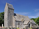
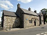
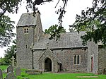
Situated immediately to the NE of the Parish Church of Holy Trinity, in the centre of Llandow village. Set within its own gardens to front and rear, bounded by a low rubble wall. | 13149 | Upload Photo |
Sutton Farmhouse | Llandow SS9445972320 51°26′24″N3°31′12″W / 51.44003°N 3.51988°W | 22 February 1963 | Farmhouse | 13151 | Upload Photo | |
Church of St Cattwg | Llan Maes SS9807469486 51°24′55″N3°28′01″W / 51.41522°N 3.46707°W | 22 February 1963 | Church | In the centre of Llanmaes village. | 13160 | |
Church of St Brynach | Penllyn SS9794574610 51°27′41″N3°28′13″W / 51.46126°N 3.47041°W | 22 February 1963 | Church | At the very southern point of the community and about 1.5 km south of Penllyn village. | 13164 | |
Church of St Hilary | St Hilary (Llanfair) ST0161473263 51°26′59″N3°25′02″W / 51.449799°N 3.417236°W | 22 February 1963 | Church | 13170 | ||
Old Beaupre Farmhouse | Llanfair ST0087972050 51°26′20″N3°25′39″W / 51.438767°N 3.427469°W | 22 February 1963 | Farmhouse | Located at the SE corner of Old Beaupre Castle, attached to the E end of the S range of the ruined manor house, aligned on a N/S axis. | 13172 | |
Church of St Cadoc, Cadoxton | Cadoxton, Barry ST1299269347 51°24′59″N3°15′09″W / 51.416463°N 3.252580°W | 18 September 1962 | Church | 13175 | ||
Church of St Dyfran and St Teilo, Merthyr Dyfan | Merthyr Dyfan, Barry ST1149569458 51°25′02″N3°16′27″W / 51.41723°N 3.27413°W | 18 September 1962 | Church | 13177 | ||
Barry Castle | Barry ST1008667197 51°23′48″N3°17′38″W / 51.39668°N 3.29381°W | 18 September 1962 | Castle | Remains of a fortified manor dating from circa 1300-1350. At junction of Porth-y-Castell and Park Road, Barry. [3] [4] | 13180 | |
Cowbridge town walls | Cowbridge with Llanblethian SS9926874618 51°27′42″N3°27′05″W / 51.46156°N 3.45137°W | 12 May 1963 | Town wall | On east side of The Butts, from rear of Mason's Arms, to bastion at southwest angle, thence along north side of Town Mill Road. | 13181 | |
South Gate (Porth y Felin) | Cowbridge with Llanblethian SS9932774574 51°27′40″N3°27′02″W / 51.46118°N 3.45051°W | 12 May 1963 | Gate | At south end of Church Street. | 13183 | |
Cowbridge Grammar School | Cowbridge with Llanblethian SS9934974581 51°27′40″N3°27′01″W / 51.461247°N 3.450195°W | 18 April 1973 | Apartments | To south of Parish Church. | 13185 | |
Cowbridge Town Hall | Cowbridge SS9956874653 51°27′43″N3°26′49″W / 51.46193°N 3.44706°W | 12 May 1963 | Town hall | Prominently sited near the east end of High Street, with rear elevations to Town Hall Square. | 13200 | |
The Great House, Cowbridge | Cowbridge SS9948574646 51°27′43″N3°26′54″W / 51.46185°N 3.44826°W | 12 May 1963 | 16th century L-shaped hall house, two storeys with attic, about 80m east of junction with Church Street. [5] [6] | 13221 | Upload Photo | |
Boverton Place including attached bee-boles | Llantwit Major SS9825868342 51°24′18″N3°27′51″W / 51.404972°N 3.464099°W | 9 October 1982 | On the south side of Boverton village centre. | 13245 | ||
Llantwit Major Town Hall | Llantwit Major SS9673868717 51°24′29″N3°29′10″W / 51.408067°N 3.486053°W | 22 February 1963 | Town hall | In the centre of Llantwit Major. | 13248 | |
Dovecote, Llantwit Major | Llantwit Major SS9655068603 51°24′25″N3°29′19″W / 51.407008°N 3.488722°W | 22 February 1963 | Dovecote | About 110m south-west of the Church of St. Illtud. | 13253 | |
The Gatehouse, Llantwit Major | Llantwit Major SS9656468661 51°24′27″N3°29′19″W / 51.407532°N 3.488537°W | 22 February 1963 | Gatehouse | About 80m south-west of the Church of St. Illtud. The building is on the roadside and is sited near the south-east corner of the 'Monastery' field. | 13254 | |
Old Swan Inn, Llantwit Major | Llantwit Major SS9674368740 51°24′30″N3°29′10″W / 51.40827°N 3.48599°W | 16 December 1952 | Public house | In the centre of Llantwit Major just to the north of The Town Hall. | 13260 | |
Ty-Mawr (or Great House) | Llantwit Major SS9669269223 51°24′45″N3°29′13″W / 51.41261°N 3.48686°W | 22 February 1963 | About 500m north of the Church of St. Illtud at the northern entrance to the town. | 13271 | ||
St Mary's Church | Monknash, St Donats SS9210770468 51°25′23″N3°33′11″W / 51.42294°N 3.55314°W | 22 February 1963 | Church | About 200m east of the road junction in the centre of Monknash on the south side of the road going towards St Donats. | 13311 | |
St Peter's Church, Penarth | Penarth ST1687570568 51°25′41″N3°11′49″W / 51.42802°N 3.19704°W | 19 November 1990 | Church | On east of minor road branching off Sully Road. To north of Cogan Old Hall Farm. [7] [8] | 13370 | |
Whitehouse Cottage | Barry ST1031566364 51°23′21″N3°17′25″W / 51.38923°N 3.29031°W | 2 July 1978 | House | The oldest inhabited house in Barry, dating from the late 16th century. [9] [10] | 13400 | |
Llandough Castle | Llandough SS9947872999 51°26′49″N3°26′52″W / 51.44705°N 3.44789°W | 13 May 1981 | Castle | 13408 | ||
The gatehouse, Llandough Castle (including attached boundary walls) | Llanfair SS9948972975 51°26′49″N3°26′52″W / 51.44683°N 3.44772°W | 16 December 1952 | Gatehouse | 13421 | ||
Great House with Forecourt Walls & Gatepiers | Llanblethian SS9888973935 51°27′19″N3°27′24″W / 51.45536°N 3.45663°W | 17 May 1988 | House dating from circa 1600 with a facade dated 1703, about 100m southwest of bridge over River Thaw. [11] [12] | 13424 | ||
Barn and stable to east of Llanmithangel Place, Llanmithangel | Llandow SS9819171963 51°26′15″N3°27′58″W / 51.43751°N 3.46610°W | 19 September 1989 | Farm buildings | 13436 | Upload Photo | |
Barry Dock Offices | Barry ST1221867659 51°24′04″N3°15′48″W / 51.40117°N 3.26329°W | 30 July 1990 | Prominently sited, overlooking Docks to the south, below the town on a flat site near Castleisland Point; railway immediately to rear. | 13443 | ||
Pedestal and statue of David Davies | Barry ST1221267615 51°24′03″N3°15′48″W / 51.40077°N 3.26336°W | 30 July 1990 | Statue | Statue of engineer, industrialist and entrepreneur David Davies (1818–1890). On the seaward side of the road in front of Barry Dock Board Offices, overlooking the docks. [13] [14] | 13445 | |
Sully Hospital | Sully ST1406267522 51°24′01″N3°14′12″W / 51.40022°N 3.23675°W | 6 November 1990 | Reached along a byroad one-and-a-half km southwest from B4267 near west outskirts of Sully. The hospital is sited in extensive, wooded grounds at Hayes Point overlooking the Bristol Channel. | 13447 | ||
Dyffryn House | St Nicholas and Bonvilston ST0953372415 51°26′37″N3°18′11″W / 51.443499°N 3.303092°W | 15 September 1992 | Set within the large public grounds of Dyffryn Gardens; 2km to south of St Nicholas. | 13469 | ||
Garnllywd Farmhouse, Lannfythin | Llancarfan ST0572771280 51°25′58″N3°21′27″W / 51.43267°N 3.35754°W | 14 February 1952 | Farmhouse | 13592 | Upload Photo | |
Treguff Farmhouse, Treguff | Llancarfan ST0308571113 51°25′51″N3°23′44″W / 51.430727°N 3.395484°W | 14 February 1952 | Farmhouse | 13593 | Upload Photo | |
Trewallter Fawr Farmhouse | Walterston ST0688571129 51°25′53″N3°20′27″W / 51.431509°N 3.340843°W | 28 January 1963 | Farmhouse | Set on the east side of the Walterston hamlet to the northeast of the Llancarfan village. | 13606 | |
St Illtyd's parish church, Llantrithyd | Llantrithyd ST0438572792 51°26′46″N3°22′38″W / 51.446041°N 3.377244°W | 28 January 1963 | Church | 13609 | ||
Church of St Cadoc, Pendoylan | Pendoylan ST0598876685 51°28′53″N3°21′19″W / 51.48130366683°N 3.3552214524103°W | 28 January 1963 | Church | 13613 | ||
The Blue Anchor Inn | Rhoose ST0350466686 51°23′28″N3°23′18″W / 51.391004509182°N 3.3882531272316°W | 28 January 1963 | Restaurant | In the centre of East Aberthaw village on the east side of the road. | 13614 | |
St Mary's Church, Penmark | Rhoose ST0584868847 51°24′39″N3°21′19″W / 51.410824454652°N 3.3551490786726°W | 28 January 1963 | Church | In the centre of Penmark village on the north side of the road to Barry. | 13617 | |
Church of St Peter, Peterston Super Ely | Peterston Super Ely ST0826376406 51°28′45″N3°19′21″W / 51.479169988775°N 3.3223971348052°W | 28 January 1963 | Church | In the village centre set within a large walled rectangular churchyard with entrances at SE and SW. | 13618 | |
St Curig's Church | Porthkerry ST0823566612 51°23′28″N3°19′13″W / 51.391125636377°N 3.3202589908065°W | 28 January 1963 | Church | On the eastern boundary of the community set to the south-east of Porthkerry village green. | 13619 | |
Church of St Andrew | St Andrews Major (Dinas Powys) ST1385571467 51°26′08″N3°14′26″W / 51.43565°N 3.24069°W | 28 January 1963 | Church | On low-lying ground in the centre of the rural hamlet (northwest of the urban development of Dinas Powys) standing in a roughly rectangular churchyard with retaining wall incorporating stone stiles. [15] [16] | 13625 | |
The Old Rectory | St Andrews Major (Dinas Powys) ST1385971419 51°26′07″N3°14′26″W / 51.43522°N 3.24062°W | 28 January 1963 | (ex)House | 
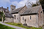
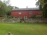
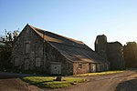
Ex priest's house probably dating back to the 15th century, now used as a garage. Situated southwest of the church, within the grounds of The Rectory and reached by a drive through that property. [17] [18] | 13626 | |
Church of St George, St Georges Super Ely | St Georges Super Ely ST1045776649 51°28′54″N3°17′27″W / 51.481706603337°N 3.2908742400847°W | 28 January 1963 | Church | A little to the E of the hamlet of St Georges which developed round Castle Farm, main approach from N, the centre of a small cluster of buildings grouped round the churchyard, close to the Ely River. | 13633 | |
Church of St Bleiddian | Wenvoe ST1102972921 51°26′54″N3°16′54″W / 51.44828511371°N 3.2816997940536°W | 28 January 1963 | Church | 
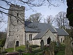
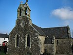
In the centre of St Lythans hamlet, set back from the road, reached by a short track and surrounded by a roughly circular walled churchyard incorporating stone stiles. | 13635 | |
Parish church of St Nicholas, St Nicholas | St Nicholas ST0901874367 51°27′39″N3°18′40″W / 51.460963306891°N 3.3110027068773°W | 28 January 1963 | Church | 13636 | ||
Church of St Mary, Wenvoe | Wenvoe ST1219672690 51°26′47″N3°15′53″W / 51.446391077808°N 3.2648535446914°W | 28 January 1963 | Church | In the centre of Wenvoe village, fronting the main thoroughfare, in a roughly rectangular churchyard entered through a stone arch at NE. | 13643 | |
Coach-house and stables at Coedarhydyglyn | St Georges Super Ely ST1049075173 51°28′06″N3°17′24″W / 51.468443766488°N 3.2900247123723°W | 13 September 1994 | To the NE of the main house, on the same plateau. | 14865 | Upload Photo | |
Sliding Bridge at N entrance to Basin | Barry ST1224167139 51°23′47″N3°15′46″W / 51.396497996724°N 3.2628297581838°W | 13 February 1996 | Bridge | Spans N entrance to Dock Basin. | 16562 | |
Ewenny Priory Barn | Ewenny SS9117077815 51°29′20″N3°34′08″W / 51.488798°N 3.568877°W | 3 March 1998 | Barn | Forming part of the north boundary of Ewenny Priory house courtyard, backing onto Abbey Road, just south of Ewenny River and west of the Priory. [19] [20] | 19463 | |
East Precinct Wall at Ewenny Priory (house) | Ewenny SS9128977804 51°29′19″N3°34′02″W / 51.48872°N 3.56716°W | 3 March 1998 | Aligned roughly north/south in Ewenny Priory (house) garden, joining churchyard at southeast and former southeast gatehouse. | 19465 | Upload Photo | |
Former Southeast Tower at Ewenny Priory (house) | Ewenny SS9130777755 51°29′18″N3°34′01″W / 51.488285°N 3.566886°W | 3 March 1998 | At the southeast corner of Ewenny Priory (house) lawned garden adjacent to the haha forming the south boundary. | 19467 | Upload Photo | |
Medieval fishpool in west part of Ewenny Priory (house) gardens | Ewenny SS9114177725 51°29′17″N3°34′09″W / 51.48798°N 3.56926°W | 3 March 1998 | Fishpond | Circular fishpond in the walled garden in the west part of the Priory complex. [21] [22] | 19469 | Upload Photo |
Ty Maen | St Brides Major SS8938777066 51°28′54″N3°35′40″W / 51.481719520396°N 3.5943124312705°W | 3 March 1999 | House | 
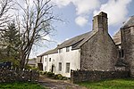
Located off the S side of the B4524 road which leads from Bridgend to Ogmore-by-Sea. The house is just W of the community boundary with Ewenny, and is cut into the hillside with sharp drops to the N and E. | 21775 | Upload Photo |
Old Leckwith Bridge | Canton / Michaelston ST1591975226 51°28′11″N3°12′43″W / 51.469754543899°N 3.2118982722425°W | 2 December 1952 | Bridge | At the S end of Canton crossing the River Ely into Leckwith; at the foot of Leckwith Woods and adjacent to the later bridge carrying the B4267 | 26487 | |
Walls, Gatepiers and Gates of Llanmaes House | Llan Maes SS9810869481 51°24′55″N3°28′00″W / 51.415182715196°N 3.4665825980712°W | 21 July 2003 | Walls and Gates | Surrounding the front and rear gardens of Llanmaes House. | 81305 | |
Church of St Michael the Archangel, St Athan | Flemingston, St Athan ST0169270068 51°25′16″N3°24′55″W / 51.421093174893°N 3.4152255251895°W | 9 March 2004 | Church | In the centre of Flemingston village. | 83115 | |
Church Farmhouse (aka Glebe Farm) | Rhoose ST0817966682 51°23′30″N3°19′16″W / 51.391745805768°N 3.3210817327852°W | 30 September 2004 | Farmhouse | On the north side of the Porthkerry village green about 50m from the Church of St Curig | 83147 | |
Outbuilding to north of Church Farmhouse | Rhoose ST0817466700 51°23′31″N3°19′16″W / 51.391906801136°N 3.3211582361448°W | 30 September 2004 | Farm building | In the garden on the north side of Church Farmhouse. | 83157 | |
Watchtower at Fonmon Castle | Rhoose ST0477867952 51°24′09″N3°22′13″W / 51.402600264438°N 3.3702886987752°W | 14 February 1952 | Watchtower | About 200m south of Fonmon Castle. | 83166 |
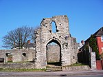
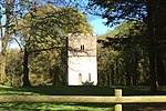
Ewenny Priory, in Ewenny in the Vale of Glamorgan, Wales, was a monastery of the Benedictine order, founded in the 12th century. The priory was unusual in having extensive military-style defences and in its state of preservation; the architectural historian John Newman described it as “the most complete and impressive Norman ecclesiastical building in Glamorgan”. Following the Dissolution of the Monasteries, parts of the priory were converted into a private house by Sir Edward Carne, a lawyer and diplomat. This Elizabethan house was demolished between 1803 and 1805 and replaced by a Georgian mansion, Ewenny Priory House. The house is still owned by the Turbervill family, descendants of Sir Edward. The priory is not open to the public apart from the Church of St Michael, the western part of the priory building, which continues to serve as the parish church for the village. The priory is in the care of Cadw and is a Grade I listed building.
There are around 1,000 listed buildings in Cardiff, the capital city of Wales. A listed building is one considered to be of special architectural, historical or cultural significance, which is protected from being demolished, extended or altered, unless special permission is granted by the relevant planning authorities. The Welsh Government makes decisions on individual cases, taking advice from the heritage agency Cadw, the Royal Commission on the Ancient and Historical Monuments of Wales and local councils.
In the United Kingdom, the term listed building refers to a building or other structure officially designated as being of special architectural, historical, or cultural significance; Grade I structures are those considered to be "buildings of exceptional interest". Listing was begun by a provision in the Town and Country Planning Act 1947. Once listed, strict limitations are imposed on the modifications allowed to a building's structure or fittings. In Wales, the authority for listing under the Planning Act 1990 rests with Cadw.
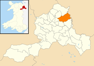
Rhondda Cynon Taf is a county borough in South Wales. It is located to the north-west of Cardiff and covers an area of 424 km2 (164 sq mi). In 2021 the population was approximately 237,500.
There are 33 Grade I listed buildings in the Vale of Glamorgan all of which are churches and priory buildings, castles, country or manor houses and associated structures such as churchyard crosses and a dovecote.
In the United Kingdom, the term listed building refers to a building or other structure officially designated as being of special architectural, historical, or cultural significance; Grade II* structures are those considered to be "particularly important buildings of more than special interest". Listing was begun by a provision in the Town and Country Planning Act 1947. Once listed, strict limitations are imposed on the modifications allowed to a building's structure or fittings. In Wales, the authority for listing under the Planning Act 1990 rests with Cadw.
This is a list of Grade II*-listed buildings in the county of Pembrokeshire, Wales.
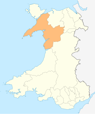
The Vale of Glamorgan is a county borough in south-east Wales. It covers an area of 331 km2 (128 sq mi) and in 2021 the population was approximately 132,500.
In the United Kingdom, the term listed building refers to a building or other structure officially designated as being of special architectural, historical, or cultural significance; Grade II structures are those considered to be "buildings of special interest which justify every effort being made to preserve them". Listing was begun by a provision in the Town and Country Planning Act 1947. Once listed, strict limitations are imposed on the modifications allowed to a building's structure or fittings. In Wales, the authority for listing under the Planning Act 1990 rests with Cadw.
Media related to Grade II* listed buildings in the Vale of Glamorgan at Wikimedia Commons