St Andrews Major

Last updated

St Andrews Major
St Andrews Church, St Andrews Major (geograph 1822907).jpg
St Andrews Major church
Vale of Glamorgan UK location map.svg
Red pog.svg
St Andrews Major
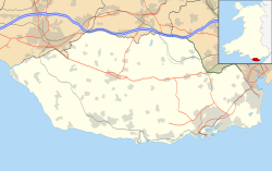
Location within the Vale of Glamorgan
OS grid reference ST139715
Principal area
Preserved county
Country Wales
Sovereign state United Kingdom
Postcode district CF
Police South Wales
Fire South Wales
Ambulance Welsh
UK Parliament
Senedd Cymru – Welsh Parliament
List of places
UK
Wales
Vale of Glamorgan
51°26′08″N3°14′27″W / 51.4356°N 3.2407°W / 51.4356; -3.2407

St Andrews Major (Welsh : Saint Andras) is a village and parish in the community of Dinas Powys in the Vale of Glamorgan, between Barry and Cardiff in south-eastern Wales.

Contents

Description

The village has a church which is over 600 years old and a primary school. Back in the early 19th century the house just past the church used to be a coaching inn, but the local Lord of the Manor had it closed down as all his farm labourers were spending their wages in there and not getting any work done (according to local history). The property is now a private residence and the village no longer has a pub.

Garnhill House (and Estate), occupying the north of the hamlet, is a Grade II listed building [1] with terraced gardens exhibited at the Royal Academy in 1904, [2] and has been occupied by the Green family for hundreds of years, expanding the Estate piecemeal. Other notable houses include The Rectory and St Andrew's House. In 1801 the village had a population of 420 [3] and 474 in 1833 [4] although now it is simply a small hamlet with fewer than 150 residents.

Geography

The surrounding soil of the parish is a strong, brown, dry earth, well adapted for grain of all kinds. The substratum of the whole is limestone. The ground is rather elevated and hilly towards the northern, side of the parish (Garnhill Estate), and flat and level towards the southern side. It is sometimes subject to partial inundation from the overflowing of a small stream, called Dinas Powis brook, which runs through the south-eastern part of the parish towards the south, and empties itself into the Bristol Channel, between the parishes of Cadoxton and Sully, which lie between St Andrews and the channel.

The nearby St Andrews Quarry has provided limestone for roadbuilding and gravel and also the windows of St Peter's Church at Dinas Powys. [5]

Church

The church is dedicated to Saint Andrew, and is in the Benefice of St Andrews Major and Michaelston-le-Pit. At the east end of the north aisle, parallel with the chancel, is a private chapel, anciently the property and burial-place of a respectable family, named Rowel, long since extinct, and the Bouville family who were owners of a great part of the parish. In the floor of this chapel there is a stone bearing an inscription of the tombs of a couple who had both lived extremely long lives:

Here lyeth the body of John Gibbon James, buried the 14 of August, 1601. And Margaret Mathew, his wife, buried the 8 of January, 1631. He aged ninety-nine, she aged one hundred and twenty-four.

John Wesley is reputed to have preached from the pulpit.

The Rectory, behind the church, was built in 1830 and its gardens used for village celebrations and events. It was built to replace The Old Rectory, (or Old Parsonage) which dates from the 15th century and still exists behind the later building. [6]

Related Research Articles

<span class="mw-page-title-main">Vale of Glamorgan</span> County borough in Wales

The Vale of Glamorgan, locally referred to as The Vale, is a county borough in the south-east of Wales. It borders Bridgend County Borough to the west, Cardiff to the east, Rhondda Cynon Taf to the north, and the Bristol Channel to the south. With an economy based largely on agriculture and chemicals, it is the southernmost unitary authority in Wales. Attractions include Barry Island Pleasure Park, the Barry Tourist Railway, Medieval wall paintings in St Cadoc's Church, Llancarfan, Porthkerry Park, St Donat's Castle, Cosmeston Lakes Country Park and Cosmeston Medieval Village. The largest town is Barry. Other towns include Penarth, Llantwit Major, and Cowbridge. There are many villages in the county borough.

<span class="mw-page-title-main">St Athan</span> Human settlement in Wales

St Athan is a village and community in the Vale of Glamorgan in South Wales. The village and its parish church are dedicated to Saint Tathan. The church dates to the 13th–14th century, though an earlier church was dated to the Norman period. The village and the adjacent dormitory village of Eglwys Brewis are known primarily for the MOD St Athan RAF base. There are two pubs in the village, as well as a football team at St Athan Football Club and the St Athan Golf Club. The community includes West Aberthaw.

<span class="mw-page-title-main">Dinas Powys</span> Human settlement in Wales

Dinas Powys is a town and community in the Vale of Glamorgan, South Wales. Its name means "fort of the provincial place" and refers to the Iron Age hillfort which overlooks the village. Dinas Powys is 5.6 miles (9.0 km) south-west of the centre of Cardiff and is situated on the A4055 road from Cardiff to Barry, making it a popular dormitory village for city commuters. It neighbours the larger town of Penarth.

<span class="mw-page-title-main">Culverhouse Cross</span> Area in Cardiff / Vale of Glamorgan, UK

Culverhouse Cross is a district straddling the boundary between Cardiff and the Vale of Glamorgan, Wales, in the community of Wenvoe.

<span class="mw-page-title-main">Michaelston-le-Pit</span> Human settlement in Wales

Michaelston-le-Pit is a village in the Vale of Glamorgan, just to the west of the city of Cardiff, Wales. It is part of the Michaelston-le-Pit and Leckwith community. The community population taken at the 2011 census was 309.

<span class="mw-page-title-main">St Hilary, Vale of Glamorgan</span> Human settlement in Wales

St Hilary is a village in the Vale of Glamorgan, Wales. It is located just south of the A48, about a mile southeast of the market town of Cowbridge. The village has a population of about 260, in approximately 80 houses. Notable landmarks in the vicinity include The Bush Inn, the Church of St Hilary, the Old Beaupre Castle, New Beaupre, Coed Hills and St. Hilary mast.

<span class="mw-page-title-main">St Lythans</span> Human settlement in Wales

St Lythans is a hamlet and former parish in the Vale of Glamorgan, southeast Wales, just outside western Cardiff. It lies southwest of Culverhouse Cross, west of Wenvoe and southwest of Twyn-yr-Odyn and is also connected by road from Dyffryn and the Five Mile Lane in the west. The megalithic St Lythans burial chamber, over 6000 years old, lies 1 km to the west of the village and the hamlet also contains the St.Lythans Parish Church or Church of St Bleddian, a Grade II* listed building.

<span class="mw-page-title-main">Cadoxton River</span> River in Wales

The Cadoxton River is a short river in the Vale of Glamorgan, South Wales and with a length of about 5 miles/8 kilometres it is one of Wales's shortest rivers.

The Vale of Glamorgan has 740 listed buildings of which 4% are Grade I listed, 10% Grade II* listed and remainder Grade II listed.

John Coates Carter (1859–1927) was an English architect. Born in Norwich, Carter is notable for his design and restoration to churches in South Wales, and in particular Glamorgan. He was partnered with John Pollard Seddon from 1884 to 1904 and after he maintained a style steeped in the traditions of the Arts and Crafts Movement to create impressive buildings such as the monastery on Caldey Island and St Luke's Church in Abercarn.

<span class="mw-page-title-main">Dyffryn, Vale of Glamorgan</span> Human settlement in Wales

Dyffryn, often Duffryn, is a village in the communities of Wenvoe and St Nicholas and Bonvilston, in the Vale of Glamorgan in south Wales. It is located 4.8 miles (7.7 km) north of the town centre of Barry, roughly 1 mile (1.6 km) west of St Lythans and 2 miles (3.2 km) south of St. Nicholas. It lies off the A4226 road, along St Lythans Road, directly east of Walterston. Dyffryn is best known for its Dyffryn Gardens and its megalithic monuments nearby including the Tinkinswood and St Lythans Burial Chamber and also the caves of nearby Goldsland. The River Waycock flows through the village.

<span class="mw-page-title-main">Flemingston</span> Human settlement in Wales

Flemingston is a small village in the Vale of Glamorgan in south Wales. It is located 8.5 miles (13.7 km) northwest by road from the town centre of Barry. It contains the Church of St. Michael the Archangel, the ruins of Flemingston Court, and Flemingston Manor or Grange, all of which are listed buildings. Historically, the parish of Flemingston was a sub-manor of Aberthaw or St Athan.

<span class="mw-page-title-main">Eglwys Brewis</span> Human settlement in Wales

Eglwys Brewis is a village in the Vale of Glamorgan in south Wales. It is located just to the north of the village of St Athan, south of Flemingston and northeast of Llantwit Major. Greenlands and St Mary Church lie to the north by road from Eglwys Brewis. The village consists primarily of residential estates which were originally built in the mid-20th century for service families stationed at nearby RAF St Athan. The estates are regularly used by driving instructors in the Vale of Glamorgan. Nant y Stepsau flows in the vicinity.

<span class="mw-page-title-main">Pencoedtre</span> District of Barry in Wales

Pencoedtre or Pencoetre, also known as Pencoedtre Village, is a northeastern suburb of Barry in the Vale of Glamorgan, Wales. It borders Gibbonsdown to the southwest and Cadoxton to the south. It has developed from a small farming hamlet into an extensive housing estate in recent years. Pencoedtre Wood is one of the largest areas of woodland in the town, and is a Site of Special Scientific Interest. Pencoedtre Park is located between Pencoedtre and Gibbonsdown.

<span class="mw-page-title-main">Wrinstone</span>

Wrinstone or Wrinston is a medieval hamlet, just east of Wenvoe, Vale of Glamorgan, south Wales. The Wrinstone estate was variously also known as Wrenston, Wrencheston or Wrenchester. The Barry Railway line ran past the hamlet and entered the Wenvoe Tunnel just to the north near Wenvoe Quarry. It closed after a fire in 1963.

A bibliography of books related to the Vale of Glamorgan, south Wales.

<span class="mw-page-title-main">Thomas Alwyn Lloyd</span> Welsh architect and town planner

Thomas Alwyn Lloyd OBE, known as T. Alwyn Lloyd, was a Welsh architect and town planner. He was one of the founders of the Town Planning Institute in 1914 and its President in 1933. He was also a founding member of the Council for the Protection of Rural Wales in 1928 and served as its chairman from 1947 to 1959. Meic Stephens described Lloyd's work as follows:

Lloyd's small-scale buildings reflected his deep feeling for place, in both historical and environmental terms, as in the Garden Villages for which he was responsible in various parts of Wales.

<span class="mw-page-title-main">The Old Rectory, St Andrews Major</span>

The Old Rectory is an early building in St Andrews Major, Vale of Glamorgan, Wales, which was originally the house for the rectors of St Andrews Church.

<span class="mw-page-title-main">Michaelston-le-Pit and Leckwith</span> Community in Vale of Glamorgan, Wales

Michaelston-le-Pit and Leckwith is a community in the Vale of Glamorgan, Wales. It is located immediately southwest of the city of Cardiff and to the north of the Vale of Glamorgan villages of Llandough and Dinas Powys. As its name suggests, the community includes the small villages of Michaelston-le-Pit and Leckwith. The community population comprises only just under 250 adults.

References

  1. "Garn-hill and attached garden terrace, Dinas Powys, Vale of Glamorgan". britishlistedbuildings.co.uk. Retrieved 30 December 2024.
  2. Michael, Statham. "Garn-Hill House, St Andrews Major, Vale of Glamorgan, by John Coates Carter (1859-1927)". victorianweb.org. Retrieved 30 December 2024.
  3. St Andrews Major, Genuki (quoting A Topographical Dictionary of The Dominion of Wales by Nicholas Carlisle, London, 1811). Retrieved 2 September 2017.
  4. Chrystal Tilney (2013), Dinas Powys, St Andrews Major and Michealston-le-Pit From Old Photographs, Amberley Publishing, p. 4, ISBN   978-1-4456-27861 , retrieved 2 September 2017
  5. Tilney, Dinas Powys, St Andrews Major and Michealston-le-Pit From Old Photographs, page 9
  6. Tilney, Dinas Powys, St Andrews Major and Michealston-le-Pit From Old Photographs, pages 10, 18.