Michaelston-le-Pit

Last updated

Michaelston-le-Pit
  • Welsh: Llanfihangel-y-pwll
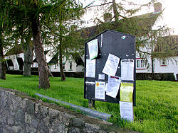
Michelston-le-Pit Village Green, Vale of Glamorgan - geograph.org.uk - 275814.jpg
Michaelston-le-Pit Village Green
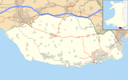
Vale of Glamorgan UK location map.svg
Red pog.svg
Michaelston-le-Pit
Location within the Vale of Glamorgan
OS grid reference ST152730
Principal area
Ceremonial county
Country Wales
Sovereign state United Kingdom
Postcode district CF
Police South Wales
Fire South Wales
Ambulance Welsh
UK Parliament
Senedd Cymru – Welsh Parliament
List of places
UK
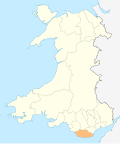
Wales
Vale of Glamorgan
51°26′56″N3°13′19″W / 51.449°N 3.222°W / 51.449; -3.222 Coordinates: 51°26′56″N3°13′19″W / 51.449°N 3.222°W / 51.449; -3.222
Church of St Michael & All Angels Church of St Michael & All Angels, Michaelston-le-Pit.jpg
Church of St Michael & All Angels

Michaelston-le-Pit (Welsh : Llanfihangel-y-pwll) is a village in the Vale of Glamorgan, just to the west of the city of Cardiff, Wales. It is part of the Michaelston-le-Pit and Leckwith community. The community population taken at the 2011 census was 309. [1]

Contents

To the south lies the town of Penarth, while to the south west lies the village of Dinas Powys. The Cwrt-yr-Ala estate stands to the west. The ancestral home of the Rous and Brain families, the estate was bought in the early 20th century by Sir Herbert Merrett, a Cardiff industrialist. In 1939, Merrett commissioned Percy Thomas to build him a new home on the site. Cwrt-yr-Ala House is a Grade II listed building and its gardens and grounds are listed, also at Grade II, on the Cadw/ICOMOS Register of Parks and Gardens of Special Historic Interest in Wales. [2] [3]

The village is built near the confluence of two small streams, which join to form the Cadoxton River. The French suffix is possibly derived from a clay pit near the southern end of the village, it having been settled on a Norman family, the De Raneghs, after the conquest.

Llanfihangel-y-pwll means The Church of St Michael and All Angels of the Pool or Pit. It is not to be confused with Latin suffixed Michaelston-super-Ely (Cardiff) or Welsh suffixed Michaelstone-y-Fedw (Newport).
Notable people

Rev. Henry Holmes Stewart (1847–1937), who won the FA Cup with Wanderers in 1873, was rector at the parish church from 1925 to 1935. [4]

The village was the home to former First Minister of Wales Rhodri Morgan. [5] [6]

Related Research Articles

<span class="mw-page-title-main">Rhodri Morgan</span> Welsh Labour politician, Former First Minister of Wales

Hywel Rhodri Morgan was a Welsh Labour politician who was the First Minister of Wales and the Leader of Welsh Labour from 2000 to 2009. He was also the Assembly Member for Cardiff West from 1999 to 2011 and the Member of Parliament for Cardiff West from 1987 to 2001. He was, as of 2018, the longest-serving First Minister of Wales. He was Chancellor of Swansea University from 2011 to 2017.

<span class="mw-page-title-main">Michaelston-super-Ely</span> Human settlement in Wales

Michaelston-super-Ely is a village, to the west of the city of Cardiff, Wales.

<span class="mw-page-title-main">River Taff</span> River in Wales which flows into Cardiff Bay

The River Taff is a river in Wales. It rises as two rivers in the Brecon Beacons; the Taf Fechan and the Taf Fawr before becoming one just north of Merthyr Tydfil. Its confluence with the River Severn estuary is in Cardiff.

<span class="mw-page-title-main">Pentraeth</span> Village and community in Anglesey, Wales

Pentraeth is a village and community on the island of Anglesey, North Wales, at grid reference SH523786. The Royal Mail postcode begins LL75. The community population taken at the 2011 census was 1,178. The village itself having a population of 557.

<span class="mw-page-title-main">Pennal</span> Village in Gwynedd, Wales

Pennal is a village and community on the A493 road in southern Gwynedd, Wales, on the north bank of the Afon Dyfi/River Dovey, near Machynlleth.

<span class="mw-page-title-main">Dinas Powys</span> Human settlement in Wales

Dinas Powys is a small town and community in the Vale of Glamorgan, South Wales. Its name means "fort of the provincial place" and refers to the Iron Age hillfort which overlooks the village. Dinas Powys is 5.6 miles (9.0 km) south-west of the centre of Cardiff and is situated on the A4055 road from Cardiff to Barry, making it a popular dormitory village for city commuters. It neighbours the larger town of Penarth.

<span class="mw-page-title-main">Grangetown, Cardiff</span> District and community in Cardiff, Wales

Grangetown is a district and community in the south of Cardiff, capital of Wales. It is one of the largest districts in the south of the city and is bordered by Riverside, Canton and Butetown. The River Taff winds its way through the area. Adjacent to the city's Cardiff Bay area, Grangetown is experiencing a period of gentrification and improvements in its infrastructure. Its population as of 2011 was 19,385 in 8,261 households. One of the "five towns of Cardiff", the others are Butetown, Crockherbtown, Newtown and Temperance Town.

<span class="mw-page-title-main">Michaelston-y-Fedw</span> Village and community in Newport, Wales

Michaelston-y-Fedw is a small rural village and community to the west of the city of Newport, Wales, on the borders of Cardiff city and Caerphilly county boroughs. The population in 2011 was 296.

<span class="mw-page-title-main">Caerhun</span> Human settlement in Wales

Caerhun is a scattered rural community, and former civil parish, on the west bank of the River Conwy. It lies to the south of Henryd and the north of Dolgarrog, in Conwy County Borough, Wales, and includes several small villages and hamlets including Llanbedr-y-cennin, Rowen, Tal-y-bont and Ty'n-y-groes. It was formerly in the historic county of Caernarvonshire. At the 2001 census, it had a population of 1,200, increasing to 1,292 at the 2011 census. It includes a large part of the Carneddau range including the lakes of Llyn Eigiau, Llyn Dulyn and Llyn Melynllyn.

<span class="mw-page-title-main">Leckwith</span> Human settlement in Wales

Leckwith is a small village in the Vale of Glamorgan, just west of Cardiff. Historically, the parish of Leckwith also included land on the east side of the river Ely that is now part of Cardiff itself. This area is also commonly known as Leckwith.

Pentre Berw is a small village located on the island of Anglesey in north Wales. It lies about 2 miles (3.2 km) south of the county town of Llangefni, and next to Gaerwen.

<span class="mw-page-title-main">Guilsfield</span>

Guilsfield is a village and local government community in Montgomeryshire, Powys, Wales. It lies beside Guilsfield Brook about three miles north of Welshpool. It is located on the B4392 road and a disused branch of the Montgomery Canal starts nearby. The community has an area of 30.01 km2 (11.59 sq mi) and had a population of 1,640 in 2001. rising to 1,727 in 2011. The community includes the villages of Burgedin and Groes-lwyd. The village itself had a population of about 1,220.

<span class="mw-page-title-main">Pwllywrach</span> Building in Vale of Glamorgan, Wales

Pwll-y-Wrach or Pwllywrach is a historic manor house to the east of Colwinston, Vale of Glamorgan, south Wales. The house and its Western garden house and Eastern garden house are all listed as Grade II listed buildings in their own right. The gardens themselves are designated Grade II on the Cadw/ICOMOS Register of Parks and Gardens of Special Historic Interest in Wales. The novelist Agatha Christie was a frequent visitor to the village and stayed at the house with her daughter Rosalind, son-in-law Hubert Prichard, and her only grandchild Mathew; her descendants, the Prichard family, still live at the former manor.

<span class="mw-page-title-main">Wrinstone</span> Building in Vale of Glamorgan, Wales

Wrinstone or Wrinston is a medieval hamlet, just east of Wenvoe, Vale of Glamorgan, south Wales. The Wrinstone estate was variously also known as Wrenston, Wrencheston or Wrenchester. The Barry Railway line ran past the hamlet and entered the Wenvoe Tunnel just to the north near Wenvoe Quarry. It closed after a fire in 1963.

<span class="mw-page-title-main">Listed buildings in Cardiff</span> Protected buildings in Cardiff, Wales

There are around 1,000 listed buildings in Cardiff, the capital city of Wales. A listed building is one considered to be of special architectural, historical or cultural significance, which is protected from being demolished, extended or altered, unless special permission is granted by the relevant planning authorities. The Welsh Government makes decisions on individual cases, taking advice from the heritage agency Cadw, the Royal Commission on the Ancient and Historical Monuments of Wales and local councils.

<span class="mw-page-title-main">Llanegryn</span> Human settlement in Wales

Llanegryn is a village and a community in Gwynedd, north-west Wales. It was formerly part of the historic county of Merionethshire. It is located within Snowdonia National Park south of the Snowdonia (Eryri) mountain range. Travelling by road, it is around 4 miles (6 km) north-east of Tywyn and 17 miles (27 km) south-west of Dolgellau. The nearest railway stations are at Tonfanau and Llwyngwril, both less than 3 miles (5 km) away.

<span class="mw-page-title-main">Llanddulas and Rhyd-y-foel</span> Community in Conwy County Borough, Wales

Llanddulas and Rhyd-y-foel is a community in Conwy County Borough, in Wales. It is located on the coast of Liverpool Bay, at the mouth of the Afon Dulas, 2.7 miles (4.3 km) west of Abergele, 3.6 miles (5.8 km) east of Colwyn Bay and 9.0 miles (14.5 km) east of Conwy. As the name suggests, it consists of the villages of Llanddulas and Rhyd-y-foel. At the 2001 census the community had a population of 1,572, reducing slightly to 1,542 at the 2011 census.

<span class="mw-page-title-main">Grade II* listed buildings in Monmouthshire</span> List of buildings in principal area of Wales

Monmouthshire is a county and principal area of Wales. It borders Torfaen and Newport to the west; Herefordshire and Gloucestershire to the east; and Powys to the north. The largest town is Abergavenny, with the other major towns being Chepstow, Monmouth, and Usk. The county is 850 km2 in extent, with a population of 95,200 as of 2020. The present county was formed under the Local Government (Wales) Act 1994, and comprises some sixty percent of the historic county. Between 1974 and 1996, the county was known by the ancient title of Gwent, recalling the medieval Welsh kingdom. In his essay on local government in the fifth and final volume of the Gwent County History, Robert McCloy suggests that the governance of "no county in the United Kingdom in the twentieth century was so transformed as that of Monmouthshire".

<span class="mw-page-title-main">Cwrt y Brychan barn, stable and granary</span> Barn in Llansoy, Monmouthshire

The barn, stable and granary at Cwrt y Brychan , Llansoy, Monmouthshire are a range of farm buildings constructed in the 16th century. The origins are the site are ancient and the court is historically connected with the kingdom of Brycheiniog. The complex has a Grade II* listing, with the court having a separate Grade II listing.

Wydham Park is an uncompleted planned village in Peterston-super-Ely in the Vale of Glamorgan. It was the first garden suburb in Wales.

References

  1. "Community population 2011" . Retrieved 9 April 2015.
  2. Cadw. "Cwrt-yr-Ala House (Grade II) (26489)". National Historic Assets of Wales . Retrieved 24 February 2023.
  3. Cadw. "Cwrt-yr-Ala (PGW(Gm)42(GLA))". National Historic Assets of Wales . Retrieved 24 February 2023.
  4. "Stewart, Henry (STWT866HH)". A Cambridge Alumni Database. University of Cambridge.
  5. "Former first minister Rhodri Morgan died while out cycling near his home".
  6. "Rhodri Morgan talks about his retirement passion for his garden". 10 August 2011.