History
Early medieval
The original Cosmeston village grew around a fortified manor house constructed sometime around the 12th century by the De Costentin family, who were among the first Norman invaders of Wales in the early 12th century following William the Conqueror's invasion of neighbouring England in 1066. It is unlikely that the manor house at the site was a substantial building and there is documentary evidence that by 1437 the manor house had already fallen into total ruin. The village would have consisted of a number of small stone round houses, or crofts, with thatched roofs, as depicted in the current reconstruction, and the village population would have been between 50 and 100 people at most, including children.
The de Costentin family originated on the Cotentin peninsula in northern France. They were the first lords of the manor and they called the village Costentinstune, which over time became known as Cosmeston. They built the original manor house and, perhaps, a few dwellings or small farms, but for the next two centuries it appears that little further development occurred.
Later medieval period
Around 1316 the manor passed into the hands of the de Caversham family, also of Norman descent.
The buildings that have been excavated so far seem to be from the 14th century. It would appear that the de Caversham family brought a more designed approach to the development of the community and a better regulated and more compact settlement began to develop during their stewardship of the village.
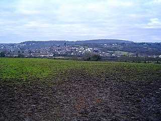
There is little sign that the village continued to develop much past the Late Middle Ages. Unusually, no Norman church was ever established in the immediate area, so by 1824 all that remained of Cosmeston village were four isolated crofts and the Little Cosmeston Farmhouse as shown on the Marquis of Bute's detailed maps of the time. It is possible that the majority of the villagers were wiped out during the Black Death plague of the 1340s or the later outbreaks, leaving Cosmeston a Deserted medieval village.
In addition to the plague, the villagers would have had to combat other difficulties. The land is low-lying and at the mercy of the many water sources that now feed the Cosmeston Lake. There is substantial evidence of drainage dykes, but even they would have struggled to keep the arable land free from waterlogging and constant flooding. Additionally the period was one of permanent political upheaval with intermittent resistance and armed conflict between several local Welsh leaders. In January 1316, for instance, Llywelyn Bren attacked Caerphilly Castle, and for the next two months there was conflict and devastation throughout the Glamorgan region.
Modern history
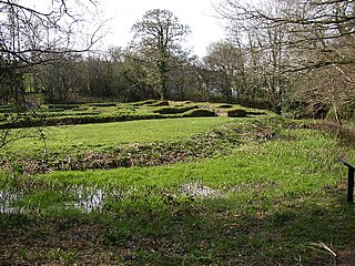
By the 20th century all evidence of the village had vanished and local residents had no idea of its previous existence. When the Snocem Concrete works and the Cosmeston limestone quarry closed in 1970, the land was developed under Countryside Commission funding as a country park. During the landscaping of the new country park the first evidence of the medieval village was unearthed and an archeological exploration was undertaken.
In addition to being open to the general public, the village accepts school tours and archeological groups, together with staging of special events and re-enactments throughout the year.
The present
Cosmeston has been used as a film location for many productions, including a 2014 episode of the hit BBC TV drama series Doctor Who , Merlin and Galavant . [1]

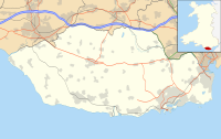
The Vale of Glamorgan, locally referred to as The Vale, is a county borough in the south-east of Wales. It borders Bridgend County Borough to the west, Cardiff to the east, Rhondda Cynon Taf to the north, and the Bristol Channel to the south. With an economy based largely on agriculture and chemicals, it is the southernmost unitary authority in Wales. Attractions include Barry Island Pleasure Park, the Barry Tourist Railway, Medieval wall paintings in St Cadoc's Church, Llancarfan, Porthkerry Park, St Donat's Castle, Cosmeston Lakes Country Park and Cosmeston Medieval Village. The largest town is Barry. Other towns include Penarth, Llantwit Major, and Cowbridge. There are many villages in the county borough.
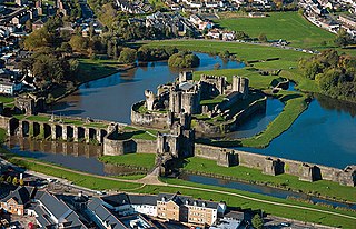
Caerphilly Castle is a medieval fortification in Caerphilly in South Wales. The castle was constructed by Gilbert de Clare in the 13th century as part of his campaign to maintain control of Glamorgan, and saw extensive fighting between Gilbert, his descendants, and the native Welsh rulers. Surrounded by extensive artificial lakes – considered by historian Allen Brown to be "the most elaborate water defences in all Britain" – it occupies around 30 acres (12 ha) and is the largest castle in Wales and the second-largest castle in the United Kingdom after Windsor Castle. It is famous for having introduced concentric castle defences to Britain and for its large gatehouses. Gilbert began work on the castle in 1268 following his occupation of the north of Glamorgan, with the majority of the construction occurring over the next three years at a considerable cost. The project was opposed by Gilbert's Welsh rival Llywelyn ap Gruffudd, leading to the site being burnt in 1270 and taken over by royal officials in 1271. Despite these interruptions, Gilbert successfully completed the castle and took control of the region. The core of Caerphilly Castle, including the castle's luxurious accommodation, was built on what became a central island, surrounding by several artificial lakes, a design Gilbert probably derived from that at Kenilworth. The dams for these lakes were further fortified, and an island to the west provided additional protection. The concentric rings of walls inspired Edward I's castles in North Wales, and proved what historian Norman Pounds has termed "a turning point in the history of the castle in Britain".

Colwinston is both a village and a community in the Vale of Glamorgan, Wales, approximately 4 miles (6.4 km) southeast of the centre of Bridgend and 21 miles (34 km) west of the centre of Cardiff. The village is located within 1⁄2 mile (0.80 km) of the A48. The population in 2005 was approximately 400 but with recent building development, the population is now estimated at over 600 people.
Sully is a village in the community of Sully and Lavernock, in the Vale of Glamorgan, Wales, lying on the northern coast of the Bristol Channel, midway between the towns of Penarth and Barry and 7 miles southwest of the Welsh capital city of Cardiff.
Walcott is a small village and civil parish on the North Norfolk coast in England between Mundesley and Happisburgh. The name is formed from the Anglian word 'walh' and the Anglo-Saxon 'cot' meaning 'cottage, hut, shelter or den'. The village is 19.1 miles (30.7 km) north east of Norwich, 11.9 miles (19.2 km) south east of Cromer and 137 miles (220 km) north east of London. The village lies 5.6 miles (9.0 km) east of the town of North Walsham.

Candleston Castle is a 14th-century fortified manor house, in ruins since the 19th century. It is 0.75 miles (1.2 km) southwest of Merthyr Mawr, Glamorgan, Wales, now Bridgend County Borough and just 0.75 miles (1.2 km) northwest of Ogmore Castle, separated by the River Ogmore. Candleston's original long and narrow rectangular structure lay across the western end of a low narrow promontory, suggesting a defensive position. The castle is believed to be named after the Norman family of Cantilupe, thought to be its first feudal tenants.

St Athan is a village and community in the Vale of Glamorgan in South Wales. The village and its parish church are dedicated to Saint Tathan. The church dates to the 13th–14th century, though an earlier church was dated to the Norman period. The village and the adjacent dormitory village of Eglwys Brewis are known primarily for the MOD St Athan RAF base. There are two pubs in the village, as well as a football team at St Athan Football Club and the St Athan Golf Club. The community includes West Aberthaw.
Dinas Powys is a town and community in the Vale of Glamorgan, South Wales. Its name means "fort of the provincial place" and refers to the Iron Age hillfort which overlooks the village. Dinas Powys is 5.6 miles (9.0 km) south-west of the centre of Cardiff and is situated on the A4055 road from Cardiff to Barry, making it a popular dormitory village for city commuters. It neighbours the larger town of Penarth.

Bonvilston is a village in the Vale of Glamorgan, Wales. The village is situated on the A48 about four miles east of Cowbridge and near the Welsh capital city of Cardiff. The population in 2011 was 392.

Cosmeston Lakes Country Park is a public country park in Wales, owned and managed by Vale of Glamorgan Council. It is situated between Penarth and Sully, Vale of Glamorgan, 7.3 miles from Cardiff. On 1 May 2013 the country park was designated a Local Nature Reserve. Parts are Sites of Special Scientific Interest. The park, visitor centre, and cafe are open all year round.
Penhallam is the site of a fortified manor house near Jacobstow in Cornwall, England. There was probably an earlier, 11th-century ringwork castle on the site, constructed by Tryold or his son, Richard fitz Turold in the years after the Norman invasion of 1066. Their descendants, in particular Andrew de Cardinham, created a substantial, sophisticated manor house at Penhallam between the 1180s and 1234, building a quadrangle of ranges facing onto an internal courtyard, surrounded by a moat and external buildings. The Cardinhams may have used the manor house for hunting expeditions in their nearby deer park. By the 14th century, the Cardinham male line had died out and the house was occupied by tenants. The surrounding manor was broken up and the house itself fell into decay and robbed for its stone. Archaeological investigations between 1968 and 1973 uncovered its foundations, unaltered since the medieval period, and the site is now managed by English Heritage and open to visitors.

Llanblethian is a village in the Vale of Glamorgan in Wales which sits upon the River Thaw. It makes up part of the community of Cowbridge with Llanblethian, which consists of the village itself, the larger market town of Cowbridge and Aberthin.
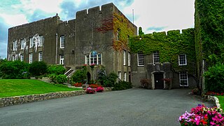
Fonmon Castle is a fortified medieval castle near the village of Fonmon in the Vale of Glamorgan and a Grade I listed building. The castle's gardens are designated Grade II on the Cadw/ICOMOS Register of Parks and Gardens of Special Historic Interest in Wales. With its origins rooted in the 12th century it is today seen as a great architectural rarity, as it is one of few buildings that was drastically remodelled in the 18th century, but not Gothicized. The castle is believed to have remained under the ownership of just two families throughout its history; from Norman times, it was owned by the St Johns, and from 1656, by the descendants of Colonel Philip Jones.

Penrhys is a village in the county borough of Rhondda Cynon Taf, Wales, situated on a hillside overlooking both valleys of Rhondda Fawr and Rhondda Fach. It is situated around 1,100 ft above sea level and is a district of Tylorstown. Until the late 16th century, Penrhys was an important Christian pilgrimage site.

Westnewton is a small village and civil parish in Cumberland, Cumbria, England. The 2011 census had a population of 265. The village of Westnewton is situated to the north-west of the Lake District, on the relatively flat plain halfway between the Lake District hills and the Solway Firth. It is a small village located two miles north of Aspatria, on the B5301 Aspatria and Silloth road. The small hamlet of New Cowper is located one-and-a-half miles to the north-west. The landscape generally in this area is one of gently undulating fields, relatively devoid of features other than the thorn field-hedges, with shallow valleys carrying small streams, such as the Black Dub beck. Westnewton has a school called St Matthew's Church of England School, a church called St Matthew's Church, and a cemetery. There used to be a public house called the Swan Inn but this has closed.

Wrinstone or Wrinston is a medieval hamlet, just east of Wenvoe, Vale of Glamorgan, south Wales. The Wrinstone estate was variously also known as Wrenston, Wrencheston or Wrenchester. The Barry Railway line ran past the hamlet and entered the Wenvoe Tunnel just to the north near Wenvoe Quarry. It closed after a fire in 1963.

Llanilid is a small settlement of in the county borough of Rhondda Cynon Taf, Wales. It is in the historic county of Glamorgan. Llanilid is part of the community of Llanharan along with the villages of Bryncae, Brynna, Ynysmaerdy, Peterston-super-Montem and Llanharan itself.

St Brides Major is a community on the western edge of the Vale of Glamorgan, South Wales. Its largest settlement is the village of St Brides Major, and also includes the villages of Ogmore-by-Sea and Southerndown, and the hamlets of Ogmore Village, Castle-upon-Alun, Heol-y-Mynydd, Norton and Pont-yr-Brown It is notable for coastal geology and scenery, limestone downlands and fossilised primitive mammals, sea cliffs and beaches, two Iron Age hillforts, three medieval castle sites,, two stepping stone river crossings and a clapper bridge. Three long distance paths cross the community. It is the western limit of the Vale of Glamorgan Heritage Coast, and has a visitor centre and tourist facilities.

Tythegston is a conservation area village located close to Cardiff and Swansea on the south coast of Bridgend, Wales. It is home to Tythegston Court, a Grade II listed manor house at the centre of the 1,200 acre Tythegston Estate which is designated at Grade II on the Cadw/ICOMOS Register of Parks and Gardens of Special Historic Interest in Wales. The estate has been owned by the Knight family for some 350 years and operates as a farming and property enterprise, with an industrial estate, as well as hosting green energy and food production. The seaside town of Porthcawl, with its numerous beaches is within 3 miles, as is Bridgend inter-city rail station. The village covers an area of 2,871 acres (1,162 ha). It is part of the community of Merthyr Mawr.
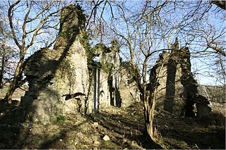
East Orchard Castle is a ruined building near St Athan in the Vale of Glamorgan, Wales, whose remains date mainly from the 14th century.