St Nicholas
| |
|---|---|
 | |
 St Nicholas Location within the Vale of Glamorgan | |
| Area | 0.2450 km2 (0.0946 sq mi) |
| Population | 654 (2021 Census) [1] |
| • Density | 2,669/km2 (6,910/sq mi) |
| • Cardiff | 1.74 mi (2.8 km) |
| Principal area | |
| Preserved county | |
| Country | Wales |
| Sovereign state | United Kingdom |
| Post town | CARDIFF |
| Postcode district | CF5 |
| Dialling code | 01446 and 029 |
| Police | South Wales |
| Fire | South Wales |
| Ambulance | Welsh |
| UK Parliament | |
St Nicholas (Welsh: Sain Nicolas) is a village on the western outskirts of Cardiff, approximately 5 miles (8 km) from the city centre and about 6 miles (10 km) east of Cowbridge. Administratively, it forms part of the Vale of Glamorgan. According to the 2021 census, the village had a population of 654 residents.
Contents
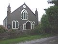
The village is bisected by the A48 road, with notable landmarks such as the parish church [2] and a primary school [3] situated to the north of the road. The surrounding area consists largely of agricultural fields and lies within the Dyffryn Basin and Ridge Slopes Special Landscape Area. [4]