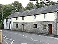
Boverton

Last updated

Boverton
Boverton village shops.jpg
Boverton village shops
Vale of Glamorgan UK location map.svg
Red pog.svg
Boverton
Location within the Vale of Glamorgan
OS grid reference SS983685
Principal area
Country Wales
Sovereign state United Kingdom
Post town Llantwit Major
Postcode district CF61
Police South Wales
Fire South Wales
Ambulance Welsh
List of places
UK
Wales
Vale of Glamorgan
51°24′N3°28′W / 51.40°N 03.46°W / 51.40; -03.46

Boverton (Welsh : Trebefered) is a village located to the east of Llantwit Major in the Vale of Glamorgan in South Wales.

Contents

History

Boverton Castle Boverton manor house.jpg
Boverton Castle

Boverton was founded during the reign of William the Conqueror in England. It is thought that he himself founded Boverton as a farming community beneath his mighty castle. However, Robert Fitzhamon is credited with founding the castle here, Boverton Place, during the 12th century. The castle was rebuilt around 1587 by Roger Seys, a land owner and attorney general of Wales. Boverton Place was an "impressive" fortified manor house of considerable size. [1] [2]

The Seys family, [3] prominent in Glamorgan throughout the 17th century, moved out in the late 17th century and it fell into decay in the following century. Local legend states the castle is haunted by the Black Lady who was spotted by men working on the castle in the early 19th Century. She was described as a tall, shadowy figure dressed in mourning clothes. [4]

Landmarks

In present-day Boverton there is a brook, several housing estates, a fish and chip shop, post office, hair salon, gentlemen's barbers, veterinary surgery and The Boverton Castle pub.

Notable people

Related Research Articles

<span class="mw-page-title-main">Vale of Glamorgan</span> County borough in Wales

The Vale of Glamorgan, often referred to as The Vale, is a county borough in the south-east of Wales. It borders Bridgend County Borough to the west, Cardiff to the east, Rhondda Cynon Taf to the north, and the Bristol Channel to the south. With an economy based largely on agriculture and chemicals, it is the southernmost unitary authority in Wales. Attractions include Barry Island Pleasure Park, the Barry Tourist Railway, Medieval wall paintings in St Cadoc's Church, Llancarfan, Porthkerry Park, St Donat's Castle, Cosmeston Lakes Country Park and Cosmeston Medieval Village. The largest town is Barry. Other towns include Penarth, Llantwit Major, and Cowbridge. There are many villages in the county borough.

<span class="mw-page-title-main">Glamorgan</span> Historic county of Wales

Glamorgan, or sometimes Glamorganshire, is one of the thirteen historic counties of Wales and a former administrative county of Wales. Originally an early medieval petty kingdom of varying boundaries known in Welsh as the Kingdom of Morgannwg, which was then invaded and taken over by the Normans as the Lordship of Glamorgan. The area that became known as Glamorgan was both a rural, pastoral area, and a conflict point between the Norman lords and the Welsh princes. It was defined by a large concentration of castles.

<span class="mw-page-title-main">Cardiff Castle</span> Grade I listed castle in Cardiff, Wales

Cardiff Castle is a medieval castle and Victorian Gothic revival mansion located in the city centre of Cardiff, Wales. The original motte and bailey castle was built in the late 11th century by Norman invaders on top of a 3rd-century Roman fort. The castle was commissioned either by William the Conqueror or by Robert Fitzhamon, and formed the heart of the medieval town of Cardiff and the Marcher Lord territory of Glamorgan. In the 12th century the castle began to be rebuilt in stone, probably by Robert of Gloucester, with a shell keep and substantial defensive walls being erected. Further work was conducted by the 6th Earl of Gloucester in the second half of the 13th century. Cardiff Castle was repeatedly involved in the conflicts between the Anglo-Normans and the Welsh, being attacked several times in the 12th century, and stormed in 1404 during the revolt of Owain Glyndŵr.

<span class="mw-page-title-main">Llantwit Major</span> Human settlement in Wales

Llantwit Major is a town and community in Wales on the Bristol Channel coast. It is one of four towns in the Vale of Glamorgan, with the third largest population after Barry and Penarth, and ahead of Cowbridge. It is 4+12 miles (7.2 km) from Cowbridge, 9 miles (14 km) from Bridgend, 10 miles (16 km) from Barry, and 15 miles (24 km) from Cardiff. It had a population of 9,486 in 2011.

<span class="mw-page-title-main">Colwinston</span> Human settlement in Wales

Colwinston is both a village and a community in the Vale of Glamorgan, Wales, approximately 4 miles (6.4 km) southeast of the centre of Bridgend and 21 miles (34 km) west of the centre of Cardiff. The village is located within 12 mile (0.80 km) of the A48. The population in 2005 was approximately 400 but with recent building development, the population is now estimated at over 600 people.

<span class="mw-page-title-main">Ogmore Castle</span>

Ogmore Castle is a Grade I listed castle ruin located near the village of Ogmore-by-Sea, south of the town of Bridgend in Glamorgan, South Wales. It is situated on the south bank of the River Ewenny and the east bank of the River Ogmore.

<span class="mw-page-title-main">Gaer, Newport</span> Human settlement in Wales

Gaer is a community and electoral district ("ward") of the city of Newport, South Wales.

<span class="mw-page-title-main">Candleston Castle</span>

Candleston Castle is a 14th-century fortified manor house, in ruins since the 19th century. It is 0.75 miles (1.2 km) southwest of Merthyr Mawr, Glamorgan, Wales, now Bridgend County Borough and just 0.75 miles (1.2 km) northwest of Ogmore Castle, separated by the River Ogmore. Candleston's original long and narrow rectangular structure lay across the western end of a low narrow promontory, suggesting a defensive position. The castle is believed to be named after the Norman family of Cantilupe, thought to be its first feudal tenants.

<span class="mw-page-title-main">St Athan</span> Human settlement in Wales

St Athan is a village and community in the Vale of Glamorgan in South Wales. The village and its parish church are dedicated to Saint Tathan. The church dates to the 13th–14th century, though an earlier church was dated to the Norman period. The village and the adjacent dormitory village of Eglwys Brewis are known primarily for the MOD St Athan RAF base. There are two pubs in the village, as well as a football team at St Athan Football Club and the St Athan Golf Club. The community includes West Aberthaw.

<span class="mw-page-title-main">Dinas Powys</span> Human settlement in Wales

Dinas Powys is a small town and community in the Vale of Glamorgan, South Wales. Its name means "fort of the provincial place" and refers to the Iron Age hillfort which overlooks the village. Dinas Powys is 5.6 miles (9.0 km) south-west of the centre of Cardiff and is situated on the A4055 road from Cardiff to Barry, making it a popular dormitory village for city commuters. It neighbours the larger town of Penarth.

<span class="mw-page-title-main">Bonvilston</span> Human settlement in Wales

Bonvilston is a village in the Vale of Glamorgan, Wales. The village is situated on the A48 about four miles east of Cowbridge and near the Welsh capital city of Cardiff. The population in 2011 was 392.

<span class="mw-page-title-main">Pendoylan</span> Human settlement in Wales

Pendoylan is a rural village and community (parish) in the Vale of Glamorgan, Wales. The village has won many awards in Best Kept Village competitions and contains 27 entries in the Council's County Treasures database, 13 of which are listed buildings.

<span class="mw-page-title-main">Fonmon Castle</span>

Fonmon Castle is a fortified medieval castle near the village of Fonmon in the Vale of Glamorgan and a Grade I listed building. The castle's gardens are designated Grade II on the Cadw/ICOMOS Register of Parks and Gardens of Special Historic Interest in Wales. With its origins rooted in the 12th century it is today seen as a great architectural rarity, as it is one of few buildings that was drastically remodelled in the 18th century, but not Gothicized. The castle is believed to have remained under the ownership of just two families throughout its history; from Norman times, it was owned by the St Johns, and from 1656, by the descendants of Colonel Philip Jones.

<span class="mw-page-title-main">St Hilary, Vale of Glamorgan</span> Human settlement in Wales

St Hilary is a village in the Vale of Glamorgan, Wales. It is located just south of the A48, about a mile southeast of the market town of Cowbridge. The village has a population of about 260, in approximately 80 houses. Notable landmarks in the vicinity include The Bush Inn, the Church of St Hilary, the Old Beaupre Castle, New Beaupre, Coed Hills and St. Hilary mast.

<span class="mw-page-title-main">Neath Castle</span>

Neath Castle is a Norman castle located in the town centre of Neath, Wales. Its construction was begun by Robert, Earl of Gloucester, the nominal Lord of Glamorgan, at a date estimated between 1114 and 1130. It is also referred to as "Granville's Castle", after Richard I de Grenville, Lord of Neath, who has also been credited with its construction. The town of Neath takes its Welsh name, "Castell-nedd", from the castle.

Evan Seys (1604–1685) was an eminent lawyer of his day who rose to national office under Oliver Cromwell as Attorney General, and served as a member of parliament after the Restoration. From c.1649 until his death he was involved in the politics of his native Glamorgan, and of Gloucestershire. He was a committed and active Protestant and an antiquarian scholar.

<span class="mw-page-title-main">Wenvoe Castle</span> Building in Vale of Glamorgan, Wales

Wenvoe Castle was a castle and country estate between Barry and Wenvoe, in the Vale of Glamorgan, south Wales. Today the former estate forms the Wenvoe Castle Golf Club. Goldsland lies on its western boundary.

<span class="mw-page-title-main">Wrinstone</span> Building in Vale of Glamorgan, Wales

Wrinstone or Wrinston is a medieval hamlet, just east of Wenvoe, Vale of Glamorgan, south Wales. The Wrinstone estate was variously also known as Wrenston, Wrencheston or Wrenchester. The Barry Railway line ran past the hamlet and entered the Wenvoe Tunnel just to the north near Wenvoe Quarry. It closed after a fire in 1963.

A bibliography of books related to the Vale of Glamorgan, south Wales.

<span class="mw-page-title-main">Tythegston</span> Human settlement in Wales

Tythegston is a conservation area village located close to Cardiff and Swansea on the south coast of Bridgend, Wales. It is home to Tythegston Court, a Grade II listed manor house at the centre of the 1,200 acre Tythegston Estate which is designated at Grade II on the Cadw/ICOMOS Register of Parks and Gardens of Special Historic Interest in Wales. The estate has been owned by the Knight family for some 350 years and operates as a farming and property enterprise, with an industrial estate, as well as hosting green energy and food production. The seaside town of Porthcawl, with its numerous beaches is within 3 miles, as is Bridgend inter-city rail station. The village covers an area of 2,871 acres (1,162 ha). It is part of the community of Merthyr Mawr.

References

  1. Spurgeon, Clifford (April 2000). An inventory of the ancient monuments in Glamorgan. Royal Commission on Ancient and Historical Monuments in Wales, H.M.S.O. p. 516. ISBN   978-1-871184-22-8 . Retrieved 19 April 2012.
  2. Glamorganshire. CUP Archive. p. 174. GGKEY:B09ZLPUCGCQ. Retrieved 19 April 2012.
  3. The History of the Great Sessions in Wales, 1542-1830: Together with the Lives of the Welsh Judges, and Annotated Lists of the Chamberlains and Chancellors, Attorneys General, and Prothonotaries of the Four Circuits of Chester and Wales; the Lord Presidents of Wales, and the Attorneys General and Solicitors General of the Marches. Priv. Print. for the author by E. Davies, Great Britain. Public Record Office. 1899. p. 100. Retrieved 19 April 2012.
  4. Trevelyan, Marie (1 January 1973). Folk-Lore and Folk-Stories of Wales. Kessinger Publishing. p. 203. ISBN   978-0-85409-938-2 . Retrieved 19 April 2012.