St Lythans

Last updated

St Lythans
St.Lythans Parish Church, near Cardiff. - geograph.org.uk - 373478.jpg
St.Lythans Parish Church
Vale of Glamorgan UK location map.svg
Red pog.svg
St Lythans
Location within the Vale of Glamorgan
Principal area
Ceremonial county
Country Wales
Sovereign state United Kingdom
Historic county
Postcode district CF
Police South Wales
Fire South Wales
Ambulance Welsh
UK Parliament
Senedd Cymru – Welsh Parliament
List of places
UK
Wales
Vale of Glamorgan
51°26′54″N3°16′57″W / 51.448333°N 3.2825°W / 51.448333; -3.2825 Coordinates: 51°26′54″N3°16′57″W / 51.448333°N 3.2825°W / 51.448333; -3.2825

St Lythans (Welsh : Llwyneliddon) is an affluent hamlet and former parish in the Vale of Glamorgan, southeast Wales, just outside western Cardiff. It lies southwest of Culverhouse Cross, west of Wenvoe and southwest of Twyn-yr-Odyn and is also connected by road from Dyffryn and the Five Mile Lane in the west. It is one of the wealthiest communities in the Vale of Glamorgan, containing some notable mansions and cottages, valued on average at over £500,000 as of 2011. [1] The megalithic St Lythans burial chamber, over 6000 years old, lies 1 km to the west of the village [2] and the hamlet also contains the St.Lythans Parish Church or Church of St Bleddian, a Grade II* listed building.

Contents

History

St Lythans Church Eglwys Sain Bleddian.JPG
St Lythans Church

In the 16th century, the manor in the area was acquired by the Button family, who built the first house about 500 yards (0.46 km) north west of the tumulus. The Manor's name was changed to Dyffryn St Nicholas and the house rebuilt in the 18th century, when the estate was purchased by Thomas Pryce. Worlton Manor was also prominent in this area for some time. Commenting on St Lythans in his 'A Topographical Dictionary of The Dominion of Wales', London, 1811, Nicholas Carlisle, says "The Resident Population of this Parish, in 1801, was 72. It is 6m. W. S.W. from Caerdiff (sic)." and notes that "Here is a Druidical Altar." [3] (Note the spelling of Cardiff, which corresponds closely to the current local Cardiff pronunciation.) By 1831, the population had grown by over 50% ("Lythan's, St. (St. Lythian), a parish in the hundred of Dinas-Powis, county of Glamorgan, South Wales, 6 miles (W. S. W.) from Cardiff, containing 103 inhabitants.") and Dyffryn House was being used as "a school for all the poor children of this parish". By now, the dolmen had been correctly identified: "There is a cromlech on St. Lythan's common." (From 'A Topographical Dictionary of Wales' by Samuel Lewis, 1833). [3] Census records show that St Lythans' population fluctuated between 81 (1881) and 136 (1861) over the rest of the 19th century. [3] In 1939, the Dyffryn Estate was leased to the Glamorgan County Council for 999 years. [4]

The area is little changed from the mid 19th century, when Llowe's 'A Topographical Dictionary of Wales' (1849) said: "There is a cromlech on a farm belonging to the Dyfryn (sic) estate; it is near the road-side, about half a mile west of the church, on the approach to Dyfryn (sic) village". [5]

Geography

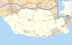
St Lythans is a small rural settlement in the Vale of Glamorgan, midway between the villages of Wenvoe and St Nicholas, about four miles (6.4 km) west-south-west of Cardiff.

The burial chamber stands in a field, Maesyfelin (The Mill Field), often shared by a herd of cows, to the south of St Lythans Road. Roadside parking is available, for 23 cars, about 50 yards (46 m) from the site, which is maintained by Cadw (to keep), [6] the Welsh Historic Environment Agency. [7] Access to the field, which slopes gently downwards towards the north west, is permitted, and is free, via a kissing gate. There is no wheelchair access, although there is an uninterrupted view of the site from the gate, about 50 yards (46 m) away.

To the south of the hamlet is Goldsland and wood, where a notable archaeological excavation has been conducted by the University of Central Lancashire since 2005.

Related Research Articles

Vale of Glamorgan county borough

The Vale of Glamorgan, often referred to as The Vale, is a county borough in Wales, bordering Bridgend, Cardiff, and Rhondda Cynon Taf. With an economy based largely on agriculture and chemicals, it is the southernmost unitary authority in Wales. Attractions include Barry Island Pleasure Park, the Barry Tourist Railway, Medieval wall paintings in St Cadoc's Church, Llancarfan, Porthkerry Park, St Donat's Castle, Cosmeston Lakes Country Park and Cosmeston Medieval Village.

Culverhouse Cross A district straddling the boundary between Cardiff and the Vale of Glamorgan, Wales

Culverhouse Cross is a district straddling the boundary between Cardiff and the Vale of Glamorgan, Wales, in the community of Wenvoe.

Bonvilston Human settlement in Wales

Bonvilston is a village in the Vale of Glamorgan, Wales. The village is situated on the A48 about four miles east of Cowbridge and near the Welsh capital city of Cardiff. The population in 2011 was 392.

Wenvoe Human settlement in Wales

Wenvoe is a village and community between Barry and Cardiff in the Vale of Glamorgan, Wales. Nearby are the Wenvoe Transmitter near Twyn-yr-Odyn and the site of the former HTV Wales Television Centre at Culverhouse Cross which is now a housing estate. It is home to the Wenvoe Quarry and Wenvoe Castle Golf Club.

St. Andrews Major Human settlement in Wales


St. Andrew's Major is a village and parish in the community of Dinas Powys in the Vale of Glamorgan, between Barry and Cardiff in south-eastern Wales.

Dyffryn Gardens Collection of botanical gardens in the care of the National Trust

Dyffryn Gardens is a collection of botanical gardens located near the villages of Dyffryn and St. Nicholas in the Vale of Glamorgan, Wales. The gardens were selected by the British Tourist Authority as one of the Top 100 gardens in the UK and are in the care of the National Trust.

Parkmill Human settlement in Wales

The village of Parkmill is a small rural settlement in the Gower Peninsula, South Wales, midway between the villages of Penmaen and Ilston, about eight miles (13 km) west of Swansea, and about one mile (1.5 km) from the north coast of the Bristol Channel. The village lies to the north of the A4118, the main South Gower road between Swansea and Port Eynon, in a wooded area, at the bottom of a valley.

Llanwnda, Pembrokeshire Human settlement in Wales

Llanwnda is a rural village and parish to the north of the Welsh county of Pembrokeshire and part of the community of Pencaer. It lies some two miles northwest of the port of Fishguard and is inside the boundaries of the Pembrokeshire Coast National Park.

St Hilary, Vale of Glamorgan Human settlement in Wales

St Hilary is a village in the Vale of Glamorgan, Wales. It is located just south of the A48, about a mile southeast of the market town of Cowbridge. The village has a population of about 260, in approximately 80 houses. Notable landmarks in the vicinity include The Bush Inn, the Church of St Hilary, the Old Beaupre Castle, New Beaupre, Coed Hills and St. Hilary mast.

History of Cardiff The 6,000 year history of Cardiff

The history of Cardiff—a City and County Borough and the capital of Wales—spans at least 6,000 years. The area around Cardiff has been inhabited by modern humans since the Neolithic Period. Four Neolithic burial chambers stand within a radius of 10 mi (16 km) of Cardiff City Centre, with the St Lythans burial chamber the nearest, at about 4 mi (6.4 km) to the west. Bronze Age tumuli are at the summit of Garth Hill, within the county's northern boundary, and four Iron Age hillfort and enclosure sites have been identified within the City and County of Cardiff boundary, including Caerau Hillfort, an enclosed area of 5.1 ha. Until the Roman conquest of Britain, Cardiff was part of the territory of an Iron Age Celtic British tribe called the Silures, which included the areas that would become known as Brecknockshire, Monmouthshire and Glamorgan. The Roman fort established by the River Taff, which gave its name to the city—Caerdydd, earlier Caerdyf, from caer (fort) and Taf—was built over an extensive settlement that had been established by the Silures in the 50s AD.

Tinkinswood Neolithic dolmen in Wales

Tinkinswood or its full name Tinkinswood Burial Chamber, also known as Castell Carreg, Llech-y-Filiast and Maes-y-Filiast, is a megalithic burial chamber, built around 6,000 years ago, during the Neolithic period, in the Vale of Glamorgan, near Cardiff, Wales.

St Lythans burial chamber Megalithic dolmen in Wales

The St Lythans burial chamber is a single stone megalithic dolmen, built around 4,000 BC as part of a chambered long barrow, during the mid Neolithic period, in what is now known as the Vale of Glamorgan, Wales.

Parc Cwm long cairn Burial chamber in Wales

Parc Cwm long cairn, also known as Parc le Breos burial chamber, is a partly restored Neolithic chambered tomb, identified in 1937 as a Severn-Cotswold type of chambered long barrow. The cromlech, a megalithic burial chamber, was built around 5850 years before present (BP), during the early Neolithic. It is about seven 12 miles (12 km) west south–west of Swansea, Wales, in what is now known as Coed y Parc Cwm at Parc le Breos, on the Gower Peninsula.

Twyn-yr-Odyn Human settlement in Wales

Twyn-yr-Odyn is a hamlet in the Vale of Glamorgan, southeast Wales, just beyond the territorial border of western Cardiff. It lies just southwest of Culverhouse Cross, very close to Wenvoe and St Lythans. The Wenvoe Transmitter is located here. It is home to a pub named the Horse and Jockey Inn. There is an allotment in the vicinity.

Goldsland Human settlement in Wales

Goldsland is a small hamlet and farm in the Vale of Glamorgan in south Wales. It is located near the boundary of the Wenvoe Castle Golf Club in the parish of Wenvoe. It lies to the east of Dyffryn and south of St Lythans and the road leading from the west passes through the farms of Old and New Wallace. Goldsland Brook flows through here. A sub-manor was reportedly held at Goldsland by a Mathew of Llandaff under the manor of Wenvoe in 1583.

Dyffryn, Vale of Glamorgan Human settlement in Wales

Dyffryn, often Duffryn, is a small village in the Vale of Glamorgan in south Wales. It is located 4.8 miles (7.7 km) north of the town centre of Barry, roughly 1 mile (1.6 km) west of St Lythans and 2 miles (3.2 km) south of St. Nicholas. It lies off the A4226 road, along St Lythans Road, directly east of Walterston. Dyffryn is best known for its Dyffryn Gardens and its megalithic monuments nearby including the Tinkinswood and St Lythans Burial Chamber and also the caves of nearby Goldsland. The River Waycock flows through the village.

Flemingston Human settlement in Wales

Flemingston is a small village in the Vale of Glamorgan in south Wales. It is located 8.5 miles (13.7 km) northwest by road from the town centre of Barry. It contains the Church of St. Michael the Archangel, the ruins of Flemingston Court, and Flemingston Manor or Grange, all of which are listed buildings. Historically, the parish of Flemingston was a sub-manor of Aberthaw or St Athan.

Eglwys Brewis Human settlement in Wales

Eglwys Brewis is a village in the Vale of Glamorgan in south Wales. It is located just to the north of the village of St Athan, south of Flemingston and northeast of Llantwit Major. Greenlands and St Mary Church lie to the north by road from Eglwys Brewis. The village consists primarily of residential estates which were originally built in the mid-20th century for service families stationed at nearby RAF St Athan. The estates are regularly used by driving instructors in the Vale of Glamorgan. Nant y Stepsau flows in the vicinity.

Wrinstone

Wrinstone or Wrinston is a medieval hamlet, just east of Wenvoe, Vale of Glamorgan, south Wales. The Wrinstone estate was variously also known as Wrenston, Wrencheston or Wrenchester. The Barry Railway line ran past the hamlet and entered the Wenvoe Tunnel just to the north near Wenvoe Quarry. It closed after a fire in 1963.

References

  1. "St Lythan's home values". Zoopla. Retrieved 29 June 2011.
  2. Castleden, Rodney (1992). Neolithic Britain: new stone age sites of England, Scotland, and Wales. Routledge. p. 383. ISBN   978-0-415-05845-2 . Retrieved 28 June 2011.
  3. 1 2 3 "GENUKI: St. Lythans". GENUKI website. GENUKI. 17 July 2007. Retrieved 3 August 2008.
  4. "History of the Dyffryn Estate: History of the House and Gardens". Dyffryn Gardens website. The Friends of Dyffryn Gardens. 2001. Retrieved 5 August 2008.
  5. Samuel Lewis. "Llowes Lythan's, St.', A Topographical Dictionary of Wales (1849), pp. 172179". British History Online website. University of London & History of Parliament Trust. Retrieved 3 August 2008.
  6. "About Cadw". Cadw website. Cadw, a division of the Welsh Assembly Government. 2008. Archived from the original on 29 June 2011. Retrieved 11 August 2008.
  7. "Places to visit: St Lythans Burial Chamber". Cadw website. Cadw, a division of the Welsh Assembly Government. 2008. Retrieved 7 August 2008.