
The River Dodder is one of the three main rivers in Dublin, Ireland, the others being the Liffey, of which the Dodder is the largest tributary, and the Tolka.
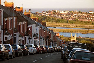
Barry is a town and community in the Vale of Glamorgan, Wales. It is on the north coast of the Bristol Channel approximately 9 miles (14 km) south-southwest of Cardiff. Barry is a seaside resort, with attractions including several beaches and the resurrected Barry Island Pleasure Park. According to Office for National Statistics 2021 estimate data, the population of Barry was 56,605.
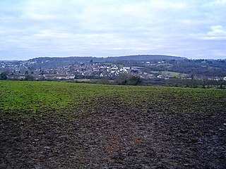
Dinas Powys is a town and community in the Vale of Glamorgan, South Wales. Its name means "fort of the provincial place" and refers to the Iron Age hillfort which overlooks the village. Dinas Powys is 5.6 miles (9.0 km) south-west of the centre of Cardiff and is situated on the A4055 road from Cardiff to Barry, making it a popular dormitory village for city commuters. It neighbours the larger town of Penarth.

Cadoxton railway station is a railway station serving Cadoxton and Palmerstown near Barry, Vale of Glamorgan, South Wales. It is located on the Barry Branch 6½ miles (10 km) south of Cardiff Central. The line continues to the terminus of the Barry Branch at Barry Island but from Barry Junction the line also continues as the Vale of Glamorgan branch to Bridgend via Rhoose for Cardiff International Airport bus link and then Llantwit Major.

Esopus Creek is a 65.4-mile-long (105.3 km) tributary of the Hudson River that drains the east-central Catskill Mountains in the U.S. state of New York. From its source at Winnisook Lake on the slopes of Slide Mountain, the Catskills' highest peak, it flows across Ulster County to the Hudson at Saugerties. Many tributaries extend its watershed into neighboring Greene County and a small portion of Delaware County. Midway along its length, it is impounded at Olive Bridge to create Ashokan Reservoir, the first of several built in the Catskills as part of New York City's water supply system. Its own flow is supplemented 13 miles (21 km) above the reservoir by the Shandaken Tunnel, which carries water from the city's Schoharie Reservoir into the creek.

Chester Creek is a 9.4-mile-long (15.1 km) tributary of the Delaware River in Delaware County, Pennsylvania, in the United States.
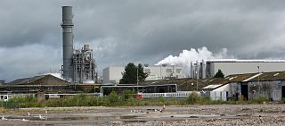
Palmerstown is a south-eastern suburb of Barry in the Vale of Glamorgan south-west of Dinas Powys and 7 miles south-west of Cardiff in Wales. It is immediately north of chemical and plastics industries such as Dow Chemicals, and Barry No.2 dock and the Atlantic Trading Estate lie south-east of No.2 dock. Its south end is separated from the A4055 Cardiff-Barry main road via Palmerston Road, (sic) a tee junction with the A4055 and access to the original part of Palmerstown's housing is via a narrow railway bridge over the Barry-Cardiff railway line and lies north-west of the former Biglis Junction which was a short distance from the so-called "Palmerston Bridge" which separates Palmerston Road from Dobbins Road.

St Andrews Major is a village and parish in the community of Dinas Powys in the Vale of Glamorgan, between Barry and Cardiff in south-eastern Wales.

The River Ely is in South Wales flowing generally southeast, from Tonyrefail to Cardiff.

Michaelston-le-Pit is a village in the Vale of Glamorgan, just to the west of the city of Cardiff, Wales. It is part of the Michaelston-le-Pit and Leckwith community. The community population taken at the 2011 census was 309.

The Ewenny River is a river in South Wales. For most of its 10 miles (16 km) length, it forms the border between the Vale of Glamorgan and Bridgend. It is a major tributary of the River Ogmore, which it joins near its estuary.

Barry Docks is a port facility in the town of Barry, Vale of Glamorgan, Wales, a few miles southwest of Cardiff on the north shore of the Bristol Channel. The docks were opened in 1889 by David Davies and John Cory as an alternative to the congested and expensive Cardiff Docks to ship coal carried by rail from the South Wales Coalfield. The principal engineer was John Wolfe Barry, assisted by Thomas Forster Brown and Henry Marc Brunel, son of the famous engineer Isambard Kingdom Brunel.

Buttrills is a northwestern-central district of Barry in the Vale of Glamorgan, in south Wales. It is also an electoral ward of the Vale of Glamorgan, the population of which taken at the 2011 census was 6,357. The centre of education in Barry in the early twentieth century, Buttrills today contains notable playing fields and Barry Cemetery.

The River Thaw is a river in the Vale of Glamorgan, south Wales. At 20 kilometres/12.4 miles, it is the longest river entirely in the Vale of Glamorgan.
Afon Col-huw is a very short river in Llantwit Major in the Vale of Glamorgan, south Wales. It is an exceptionally short river, one mile long, formed when two rivers, the Ogney Brook and the Hoddnant, converge south of Llantwit Major. Its valley, the Cwm Col-huw, is a Scheduled Ancient Monument - it was used in the Dig for Victory campaign in World War II.

Wrinstone or Wrinston is a medieval hamlet, just east of Wenvoe, Vale of Glamorgan, south Wales. The Wrinstone estate was variously also known as Wrenston, Wrencheston or Wrenchester. The Barry Railway line ran past the hamlet and entered the Wenvoe Tunnel just to the north near Wenvoe Quarry. It closed after a fire in 1963.

Wenvoe Quarry is a quarry located on the eastern edge of the Vale of Glamorgan, south Wales, approximately 5 km southwest of Cardiff city centre. It is situated on Alps Quarry Road, in an area known as "The Alps", between Wenvoe, Culverhouse Cross and Caerau. The quarry is accessed from the A4050 road.

Spring Brook is a tributary of the Lackawanna River in Lackawanna County and Luzerne County, in Pennsylvania, in the United States. It is approximately 17 miles (27 km) long and flows through Covington Township, Spring Brook Township, and Moosic in Lackawanna County and Pittston Township in Luzerne County. The watershed of the stream has an area of 57.2 square miles (148 km2). It is designated as a High-Quality Coldwater Fishery and a Migratory Fishery above Interstate 476 and as a Coldwater Fishery and a Migratory Fishery below it. A section is also designated as Class A Wild Trout Waters. The stream's tributaries include Panther Creek, Plank Bridge Creek, Rattlesnake Creek, Green Run, Monument Creek, and Covey Swamp Creek. It has a relatively high level of water quality and is very slightly acidic, with a pH of 6.4 to 6.9.

Roaring Brook is a tributary of the Lackawanna River in Lackawanna County, Pennsylvania, in the United States. It is approximately 21 miles (34 km) long and flows through Covington Township, Madison Township, Moscow, Roaring Brook Township, Elmhurst Township, Dunmore, and Scranton. The watershed of the stream has an area of 56.3 square miles (146 km2). Its named tributaries include Little Roaring Brook, Rock Bottom Creek, White Oak Run, Van Brunt Creek, Bear Brook, and East Branch Roaring Brook. It has a high level of water quality for much of its length. However, it is affected by abandoned mining land, stormwater, and other impacts in its lower reaches. Reservoirs in the watershed include the Hollister Reservoir, the Elmhurst Reservoir, and others. The stream also flows through the Nay Aug Gorge and passes over the Nay Aug Falls, which are on the National Register of Geologic Landmarks. It flows through a concrete channel in its lower reaches. The topography of the watershed contains rolling hills in its upper reaches and the mountainous land of the Moosic Mountains in its lower reaches.

The West Kill, an 11-mile-long (18 km) tributary of Schoharie Creek, flows through the town of Lexington, New York, United States, from its source on Hunter Mountain, the second-highest peak of the Catskill Mountains. Ultimately its waters reach the Hudson River via the Mohawk. Since it drains into the Schoharie upstream of Schoharie Reservoir, it is part of the New York City water supply system. It lends its name to both a mountain to its south and a small town midway along its length.


