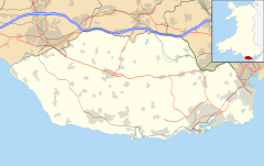
Porthkerry

Last updated

Porthkerry
Church of St Curig Porthkerry 2014.JPG
Church of St Curig
Vale of Glamorgan UK location map.svg
Red pog.svg
Porthkerry
Location within the Vale of Glamorgan
OS grid reference ST081667
Principal area
Preserved county
Country Wales
Sovereign state United Kingdom
Post town Barry
Postcode district CF62
Police South Wales
Fire South Wales
Ambulance Welsh
UK Parliament
Senedd Cymru – Welsh Parliament
List of places
UK
Wales
Vale of Glamorgan
51°23′31″N3°19′19″W / 51.392°N 3.3219°W / 51.392; -3.3219

The hamlet of Porthkerry (Welsh: Porthceri) lies on the Bristol Channel coast of South Wales within the community of Rhoose between that village and the town of Barry to the east. It is very close to the end of the runway of Cardiff International Airport. To the east of the hamlet is Porthkerry Country Park which occupies the valley leading down to the coast.

Contents

History

One of the oldest settlements in PorthKerry is the Iron Age promontory fort known as The Bulwarks, a 4.1 hectares (10 acres) site much of which is now wooded. [1] The Bulwarks, which consisted of three closely spaced overgrown banks fronted by ditches with the final side facing the cliffs to the south, were occupied well into the period of Roman occupation. [2]

A little to the north of the fort site is a church dedicated to Saint Curig. Described by Newman as "a very small church", St Curig's has a single lancet window that is thought to be 13th century, but with other features, such as the east and west windows being confirmed as from the 15th century. [2] The church door also has some very unusual, rough carvings. There are ensignia of the 'Marian Cult'. This movement wanted to push back against the downgrading of importance of the Virgin Mary in Anglican worship, but as such ideas were seen as heretical they went underground and founded secret groups and observed their own form of worship. The door carving is dated 1790 which are also evident on grave markings within the church. This would suggest that the cult was rife in Porthkerry and other parts of the Vale of Glamorgan, including near by Penmark [3] [ self-published source ] which has similar engravings on pews and benches.

On 28 November 1831 the vessel The Nepture, sailing from Newport to Wexford in Ireland, struck a rock and sank off the coast of Porthkerry. [4] On 10 January 1898 the Porthkerry Viaduct on the Vale of Glamorgan Line operated then by the Barry Railway Company was the scene of a non-fatal railway accident involving the collapse of the structure. [5] The viaduct also featured in scenes in the Doctor Who television series in 2000. [6] The Porthkerry Leisure Park hit the national headlines in November 2011 when a portion of the cliff collapsed at the edge of the site leaving some caravans hanging over the edge of the cliff. [7]

Porthkerry Country Park

View of the park from the viaduct Porthkerry Park from a train on the viaduct - geograph.org.uk - 1363104.jpg
View of the park from the viaduct
Ranger's Cottage Cottage in Porthkerry Country Park, Barry - geograph.org.uk - 1051808.jpg
Ranger's Cottage

Porthkerry Country Park is a large, public country park between the hamlet of Porthkerry and Barry town, in a valley accessible by car from the north-eastern end at the Garden Suburb area of Barry and via a road section locally known as Fishponds Hill. The western end used to be accessible to light vehicles from Rectory Hill, north-west of Porthkerry viaduct, via an unmetalled lane from the Rectory House at valley bottom (later Egerton Grey Country Guest house, opened in 1988 but closed in 2010) but later metalled as a cycle/pedestrian way to join the metalled road near Porthkerry railway viaduct and public car park. At the south-west end, a steep cliff pathway from the former Bulwarks site, east of Porthkerry Leisure Park area, leads down to Porthkerry beach skirting the Bristol Channel. Other pathways exist, one from Porthkerry Church area adjacent to Porthkerry railway viaduct and the other at the north side of the beach via the famous "Golden Stairs" from the clifftop pathway from the Garden Suburb. Fields, extensive woodland, nature trails and a pebble-stone beach are included. A small golf course has recently been converted to a ponded area with boardwalk alternative access from the car park/café area near the viaduct (April 2020), and is visited by around 250,000 people a year. [8]

The land was acquired by the Romilly family in 1812 to build a country house, and cottages, stables and a sawmill for local workers. Cliff Wood Mill was in use for a period but it believed to have been destroyed during the Glyndwr revolt in the early 15th century. The remains of it are a Scheduled Ancient Monument. Cliff Wood Cottage was originally built in 1583 by Owen Williams and fully rebuilt in the early 1790s. It was once the residence of a woman believed to be a witch, Ann Jenkins. [8] The park was fully landscaped by the Romilly family in the 1840s, [9] and they sold it to Barry Urban District Council in 1929. The park was occupied by British and American forces during World War II in the approach to D-Day, and earthworks and defences were built along the coast. [8]

The park is particularly noted for the nineteen arch Porthkerry Viaduct crossed by a railway that served as a transportation for coal from some of the South Wales Valleys north of Bridgend to Barry Docks port in the late 19th and early 20th centuries. Built in the late 1890s, the viaduct has nineteen arches which vary between 45 and 50 feet (15 metres) in width and rising to a height of 110 feet (34 metres). [10] It became Grade II listed in 1963. [11] The former Egerton Grey Country House Hotel lies near the viaduct. The house was originally built in the 17th century and functioned as a rectory for some time. [12]

On the northern side of Porthkerry Park there was a small hamlet named Cwmciddy (meaning Valley of the Black Dog in Welsh). It first appeared in the mid 13th century and by 1622 had five houses and several farm buildings, but by 1812, only three cottages and a farmhouse remained. The cottages were demolished in the 1840s by the Romilly family when Porthkerry Park was landscaped. [9] The name - although slightly anglicised - lives on in the area, in the form of a nearby public house, The Cwm Ciddy but its name was changed to the Toby Carvery by 2010 and adjoins a Travelodge hotel. An area of the park known as Cwm Barry, along the main approach road, was used for farming and contains a woodland of about 1.3 hectares with hawthorn, blackthorn, hazel, ash and sycamore trees alongside Barry Brook. The brook flows into a pond at Fishponds Hill bottom, near the only vehicular access road. [13] Cwm Barry Cottage was built in around 1845 to house the park ranger but was demolished in 1972; all that remained was a low boundary wall and fruit trees in the woodland which were once part of the cottage garden but no evidence of this now exists. [8] A mill race used to tee in with Barry Brook just north of that cottage and fed the former wood mill in the Millwood. That mill was driven by an overshot mill wheel which was also fed from a millpond and dam and race placed upstream in the Nant Talwg brook. On an unknown date after the mill became redundant, the dam was dynamited, the bulk of which is to be seen from the Mill Wood bridleway, as a massive concrete mass lying on its side. The country park is now managed by the Vale of Glamorgan Council and a Ranger's office and maintenance vehicle site is located at Nightingale Cottage halfway into the park. The included picture of Nightingale cottage, the Ranger's office, on this subject, shows a surrounding fence. This fence does not now exist (2020) and the area us now heavily CCTV monitored.[ citation needed ]

Porthkerry Park with view of the Porthkerry Viaduct PorthkerryParkAutumnSunset.png
Porthkerry Park with view of the Porthkerry Viaduct

Notable people

Related Research Articles

<span class="mw-page-title-main">Vale of Glamorgan</span> County borough in Wales

The Vale of Glamorgan, often referred to as The Vale, is a county borough in the south-east of Wales. It borders Bridgend County Borough to the west, Cardiff to the east, Rhondda Cynon Taf to the north, and the Bristol Channel to the south. With an economy based largely on agriculture and chemicals, it is the southernmost unitary authority in Wales. Attractions include Barry Island Pleasure Park, the Barry Tourist Railway, Medieval wall paintings in St Cadoc's Church, Llancarfan, Porthkerry Park, St Donat's Castle, Cosmeston Lakes Country Park and Cosmeston Medieval Village. The largest town is Barry. Other towns include Penarth, Llantwit Major, and Cowbridge. There are many villages in the county borough.

<span class="mw-page-title-main">Glamorgan</span> Historic county of Wales

Glamorgan, or sometimes Glamorganshire, is one of the thirteen historic counties of Wales and a former administrative county of Wales. Originally an early medieval petty kingdom of varying boundaries known in Welsh as the Kingdom of Morgannwg, which was then invaded and taken over by the Normans as the Lordship of Glamorgan. The area that became known as Glamorgan was both a rural, pastoral area, and a conflict point between the Norman lords and the Welsh princes. It was defined by a large concentration of castles.

<span class="mw-page-title-main">Rhoose</span> Village in the Vale of Glamorgan, Wales

Rhoose is a village and community near the sea in the Vale of Glamorgan, Wales, near Barry. The wider community includes villages and settlements such as Font-y-Gary, Penmark, East Aberthaw and Porthkerry. The population of the community in 2011 was 6,160.
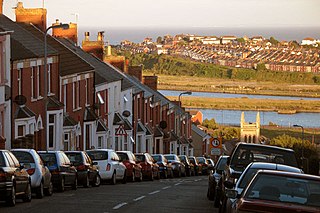
<span class="mw-page-title-main">Barry, Vale of Glamorgan</span> Town in the Vale of Glamorgan, Wales

Barry is a town in the Vale of Glamorgan, Wales, on the north coast of the Bristol Channel approximately 9 miles (14 km) south-southwest of Cardiff. Barry is a seaside resort, with attractions including several beaches and the resurrected Barry Island Pleasure Park. According to Office for National Statistics 2016 estimate data, the population of Barry was 54,673.

<span class="mw-page-title-main">Vale of Glamorgan Line</span> Commuter rail line in Wales

The Vale of Glamorgan Line is a commuter railway line in Wales, running through the Vale of Glamorgan from Barry to Bridgend, via Rhoose and Llantwit Major.

<span class="mw-page-title-main">Barry railway station</span> Railway station in the Vale of Glamorgan, Wales

Barry railway station is one of three stations serving the town of Barry, Vale of Glamorgan in South Wales. This one, Barry Town, is preceded by Barry Docks and Cadoxton stations on the Barry Branch which runs from Cardiff Central to a fourth station at Barry Island, the terminus. Barry is also the junction at the start of the Vale of Glamorgan Line which serves Rhoose and Llantwit Major and terminates at Bridgend.

<span class="mw-page-title-main">St Athan</span> Human settlement in Wales

St Athan is a village and community in the Vale of Glamorgan in South Wales. The village and its parish church are dedicated to Saint Tathan. The church dates to the 13th–14th century, though an earlier church was dated to the Norman period. The village and the adjacent dormitory village of Eglwys Brewis are known primarily for the MOD St Athan RAF base. There are two pubs in the village, as well as a football team at St Athan Football Club and the St Athan Golf Club. The community includes West Aberthaw.

<span class="mw-page-title-main">Dinas Powys</span> Human settlement in Wales

Dinas Powys is a small town and community in the Vale of Glamorgan, South Wales. Its name means "fort of the provincial place" and refers to the Iron Age hillfort which overlooks the village. Dinas Powys is 5.6 miles (9.0 km) south-west of the centre of Cardiff and is situated on the A4055 road from Cardiff to Barry, making it a popular dormitory village for city commuters. It neighbours the larger town of Penarth.

<span class="mw-page-title-main">Reddish Vale</span> Vale in Greater Manchester, England

Reddish Vale is in the Tame Valley close to Reddish, Greater Manchester, England. The centre of the vale is around the bottom of Reddish Vale Road. Reddish Vale Country Park is a country park managed by Stockport Metropolitan Borough Council. It covers 161 hectares in all and comprises some of the traditional Reddish Vale area, Reddish Vale Farm and the grazing land and Woodhall Fields, about 0.5 miles (0.80 km) to the south. Part of it is a designated local nature reserve.

<span class="mw-page-title-main">Barry Railway Company</span> Former railway and docks company in South Wales

The Barry Railway Company was a railway and docks company in South Wales, first incorporated as the Barry Dock and Railway Company in 1884. It arose out of frustration among Rhondda coal owners at congestion and high charges at Cardiff Docks as well the monopoly held by the Taff Vale Railway in transporting coal from the Rhondda. In addition, the Taff Vale did not have the required capacity for the mineral traffic using the route, leading to lengthy delays in getting to Cardiff.

<span class="mw-page-title-main">Aberthaw</span> Human settlement in Wales

Aberthaw is an area containing the villages of East Aberthaw and West Aberthaw, on the coast of South Wales about 5 miles (8 km) west of Barry. It is home to Aberthaw Cement Works, Aberthaw Lime Works, and Aberthaw Power Station, a decommissioned coal power station that was linked to the South Wales Valleys via the Vale of Glamorgan Railway. The area is historically within the parish of Penmark in the Vale of Glamorgan. The two villages of West and East Aberthaw are separated by the River Thaw. The village of East Aberthaw, near Rhoose, has a 13th-century pub. The village Baptist Chapel and Mission Room no longer exist as such and have been converted for other uses.

<span class="mw-page-title-main">Font-y-Gary</span> Human settlement in Wales

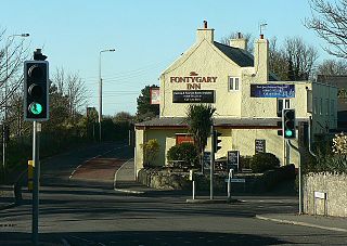
Font-y-Gary, also Fontygary, Fontegary or Fontygari, is a village adjacent to Rhoose, 3 miles south-west of Barry in the Vale of Glamorgan, on the coast of south Wales. To the north is Fonmon and Fonmon Castle. The origin of the name is uncertain but in 1587 it was documented as "Fundygary".

The Vale of Glamorgan Railway Company was built to provide access to Barry Docks from collieries in the Llynfi, Garw and Ogmore valleys. Proposed by the coalowners but underwritten by the wealthy Barry Railway Company, it opened in 1897 from near Bridgend to Barry, in Wales.

Rail transport in Cardiff has developed to provide connections to many other major cities in the United Kingdom, and to provide an urban rail network for the city and its commuter towns in southeast Wales. Today, there are three train operating companies in Cardiff: Great Western Railway, CrossCountry and Transport for Wales.

<span class="mw-page-title-main">Buttrills</span> District of Barry and ward in Wales

Buttrills is a northwestern-central district of Barry in the Vale of Glamorgan, in south Wales. It is also an electoral ward of the Vale of Glamorgan, the population of which taken at the 2011 census was 6,357. The centre of education in Barry in the early twentieth century, Buttrills today contains notable playing fields and Barry Cemetery.

The Vale of Glamorgan has 740 listed buildings of which 4% are Grade I listed, 10% Grade II* listed and remainder Grade II listed.

<span class="mw-page-title-main">Grade II* listed buildings in the Vale of Glamorgan</span>

In the United Kingdom, the term listed building refers to a building or other structure officially designated as being of special architectural, historical, or cultural significance; Grade II* structures are those considered to be "particularly important buildings of more than special interest". Listing was begun by a provision in the Town and Country Planning Act 1947. Once listed, strict limitations are imposed on the modifications allowed to a building's structure or fittings. In Wales, the authority for listing under the Planning Act 1990 rests with Cadw.

<span class="mw-page-title-main">Porthkerry Viaduct</span>

Porthkerry Viaduct is a railway viaduct near Barry in the Vale of Glamorgan, Wales.

<span class="mw-page-title-main">The Bulwarks, Porthkerry</span>

The Bulwarks, Porthkerry is a promontory fort in Rhoose, Vale of Glamorgan, on the southern coast of Wales overlooking the Bristol Channel. It probably dates to the Iron Age and continued to be occupied during the Roman period in Britain. The ramparts and ditches along the west side are well preserved, but the fortifications are heavily overgrown.

The Vale of Glamorgan Association Football League is a football league covering the area of the Vale of Glamorgan in Glamorgan, South Wales and the surrounding areas. The leagues are at the seventh and eighth levels of the Welsh football league system.

References

  1. "The Bulwarks at Cofleinp". map.coflein.co.uk. Retrieved 9 October 2014.
  2. 1 2 Newman, John (1995). Glamorgan. London: Penguin Group. p. 531. ISBN   0140710566.
  3. Legends and folklore of Bridgend and the Vale by Graham Loveluck-Edwards
  4. "Ship News", The Times (London, England) 2 December 1831. Retrieved 9 October 2014.
  5. "Accident at Porthkerry Viaduct on 10th January 1898". Railwaysarchive.co.uk. Retrieved 9 October 2014.
  6. "Porthkerry Viaduct". Doctorwholocations.net. Retrieved 9 October 2014.
  7. "Safety probe had been launched prior to Porthkerry cliff collapse". Wales Online. 3 November 2011. Retrieved 9 October 2014.
  8. 1 2 3 4 "History of Porthkerry Country Park". Vale of Glamorgan Council. Retrieved 25 January 2020.
  9. 1 2 An Inventory of the Ancient Monuments in Glamorgan:Volume III: Medieval Secular Monuments, Part II: Non Defensive. Royal Commission on Ancient and Historical Monuments in Wales, H.M.S.D. 1976. p. 224.
  10. "The viaduct and World War II". Vale of Glamorgan Council. Retrieved 15 December 2014.
  11. "Porthkerry Railway Viaduct (Partly in the Community of Rhoose), Porthkerry Park, Barry". British Listed Buildings. Retrieved 15 December 2014.
  12. Porter, Darwin; Prince, Danforth (8 September 2006). Frommer's England 2007. John Wiley and Sons. p. 704. ISBN   978-0-470-00746-4.
  13. "Areas of the Park". Vale of Glamorgan Council. Retrieved 25 January 2020.
  14. "Sheriffs For The Year 1869." The Times (London, England) 6 February 1869. Retrieved 9 October 2014.