
The Vale of Glamorgan, locally referred to as The Vale, is a county borough in the south-east of Wales. It borders Bridgend County Borough to the west, Cardiff to the east, Rhondda Cynon Taf to the north, and the Bristol Channel to the south. With an economy based largely on agriculture and chemicals, it is the southernmost unitary authority in Wales. Attractions include Barry Island Pleasure Park, the Barry Tourist Railway, Medieval wall paintings in St Cadoc's Church, Llancarfan, Porthkerry Park, St Donat's Castle, Cosmeston Lakes Country Park and Cosmeston Medieval Village. The largest town is Barry. Other towns include Penarth, Llantwit Major, and Cowbridge. There are many villages in the county borough.

South Glamorgan is a preserved county of Wales.

Ewenny is a village and community (parish) on the River Ewenny in the Vale of Glamorgan, Wales.

Colwinston is both a village and a community in the Vale of Glamorgan, Wales, approximately 4 miles (6.4 km) southeast of the centre of Bridgend and 21 miles (34 km) west of the centre of Cardiff. The village is located within 1⁄2 mile (0.80 km) of the A48. The population in 2005 was approximately 400 but with recent building development, the population is now estimated at over 600 people.

Ogmore Castle is a Grade I listed castle ruin located near the village of Ogmore in the Vale of Glamorgan, Wales, east of Ogmore-by-Sea, and south of the town of Bridgend. It is situated on the south bank of the Ewenny River and the east bank of the River Ogmore.
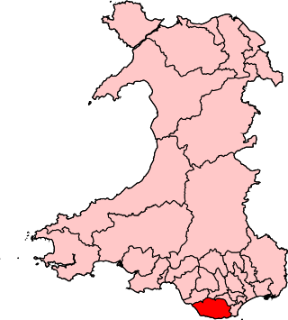
Vale of Glamorgan is a constituency represented in the House of Commons of the UK Parliament since 2024 by Kanishka Narayan, a Labour MP.

Merthyr Mawr is a village and community in Bridgend, Wales. The village is about 2+1⁄2 miles from the centre of Bridgend town. The population of the community at the 2011 census was 267. The community occupies the area west of the Ewenny River, between Bridgend and Porthcawl. It takes in the settlement of Tythegston and a stretch of coastal sand dunes known as Merthyr Mawr Warren. It is in the historic county of Glamorgan.
Schwyll Aquifer was historically known as 'the Great Spring of Glamorgan'. Welsh Water uses the resurgence at the Schwyll Spring near Ewenny in the Vale of Glamorgan as the main source of water for the Bridgend area. Now functioning as a backup supply, it has a number of associated source protection zones policed by Natural Resources Wales.

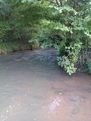
The Ewenny River is a river in South Wales. For most of its 10 miles (16 km) length, it forms the border between the Vale of Glamorgan and Bridgend. It is a major tributary of the River Ogmore, which it joins near its estuary.

Llandow is a village and community in the Vale of Glamorgan, Wales. The community population taken at the 2011 census was 726. The village is located 15 miles (24 km) south west of Cardiff. The community includes the villages of Sigingstone and Llysworney.
The Cadoxton River is a short river in the Vale of Glamorgan, South Wales and with a length of about 5 miles/8 kilometres it is one of Wales's shortest rivers.

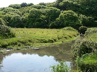
The River Thaw is a river in the Vale of Glamorgan, south Wales. At 20 kilometres/12.4 miles, it is the longest river entirely in the Vale of Glamorgan.
Afon Col-huw is a very short river in Llantwit Major in the Vale of Glamorgan, south Wales. It is an exceptionally short river, one mile long, formed when two rivers, the Ogney Brook and the Hoddnant, converge south of Llantwit Major. Its valley, the Cwm Col-huw, is a Scheduled Ancient Monument - it was used in the Dig for Victory campaign in World War II.

The B4265 road is a main road in the Vale of Glamorgan, southeastern Wales, running in a northwesterly direction along near the coast. It links Cardiff Airport to Bridgend, lasting for 15.9 miles (25.6 km). The road begins at the roundabout near the airport and the village of Penmark at 51°24′21″N3°20′39″W as a continuation of the A4226 road leading from Barry. Passing the junction turnoff to Gileston and St Athan, at Llantwit Major, the B4270 road branches off to the northwest to Llandow Industrial Estate. The road then moves progressively in northwesterly direction until St Brides Major, where the B4524 road to the south connects it to Southerndown and Ogmore-by-Sea. At St Brides Major, the road shifts to a northerly direction, where it passes Ewenny and Ogmore village leading to Bridgend, where it joins the A48 road and finally A473 road at 51°30′7″N3°34′34″W.

St Brides Major is a community on the western edge of the Vale of Glamorgan, South Wales. Its largest settlement is the village of St Brides Major, and also includes the villages of Ogmore-by-Sea and Southerndown, and the hamlets of Ogmore Village, Castle-upon-Alun, Heol-y-Mynydd, Norton and Pont-yr-Brown It is notable for coastal geology and scenery, limestone downlands and fossilised primitive mammals, sea cliffs and beaches, two Iron Age hillforts, three medieval castle sites,, two stepping stone river crossings and a clapper bridge. Three long distance paths cross the community. It is the western limit of the Vale of Glamorgan Heritage Coast, and has a visitor centre and tourist facilities.
Nash Manor is a Grade I listed building in Llandow, near Cowbridge in the Vale of Glamorgan, south Wales. It became a Grade I listed building on 16 December 1952.
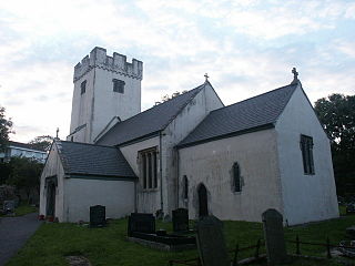
St Michael and All Angels Church is a Grade I listed church in Colwinston, in the Vale of Glamorgan, south Wales. It became a Grade I listed building on 22 February 1963. The church is said to have been built in 1111. The earliest mention of this parish church comes in the form of an 1141 confirmation of a donation made to the church by Maurice de Londres. The church and all of its possessions were given to the Abbey of Gloucester; this was confirmed circa 1200 when the Bishop of Landaff assigned a resident chaplain to the church. In 1254, the church was listed with a valuation of five marks. By 1291, it was combined with the valuation of Ewenny Priory.

Llandow, is the name of an electoral ward in the west of the Vale of Glamorgan, Wales. It covers its namesake community of Llandow as well as the neighbouring communities of Colwinston and Llangan. Since 1995 the ward has elected a county councillor to the Vale of Glamorgan Council.
The 1995 Vale of Glamorgan Council election was held on 4 May 1995 to the new Vale of Glamorgan Council unitary authority in Vale of Glamorgan, Wales. It took place on the same day as other council elections in Wales and England. These were the first elections since the re-organization of local government in Wales.

