Llancarfan

Last updated

Llancarfan
Llancarfan, St Cadoc (35873785235).jpg
The parish church of Saint Cadoc
Vale of Glamorgan UK location map.svg
Red pog.svg
Llancarfan
Location within the Vale of Glamorgan
Population747 (2011)
OS grid reference ST051701
Community
  • Llancarfan
Principal area
Preserved county
Country Wales
Sovereign state United Kingdom
Post town BARRY
Postcode district CF62
Post townCOWBRIDGE
Postcode district CF71
Police South Wales
Fire South Wales
Ambulance Welsh
UK Parliament
Senedd Cymru – Welsh Parliament
List of places
UK
Wales
Vale of Glamorgan
51°25′27″N3°21′56″W / 51.4242°N 3.3656°W / 51.4242; -3.3656

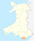
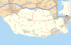
Llancarfan is a rural village and community in the Vale of Glamorgan, Wales. The village, located west of Barry and near Cowbridge, has a well-known parish church, the site of Saint Cadoc's 6th-century clas, famed for its learning. Cainnech of Aghaboe, Caradoc of Llancarfan and many other Welsh holy men studied there. Antiquarian Iolo Morganwg was born in the hamlet of Pen-onn near Llancarfan. At the 2001 census, the community had a population of 736. [1] In the 2011 census, the population was 747. [2] Most of the village lies within a conservation area designated by the local authority in 1971. Buildings listed as being of special historic interest include The Fox and Hounds public house, the former Bethlehem Chapel, the former Wesleyan Chapel, Chapel Cottage, Great House, Corner House and Llancarfan Primary School. [3] The community includes village of Moulton.

The spacious church, which in the later Middle Ages belonged to Gloucester Abbey, contains a stoup and interesting remains of a rood screen, now adapted as a reredos. In early 2008, architects discovered medieval wall painting in the church under layers of whitewash, including one of only three depictions of St George to be found in churches in Wales. Conservation-restoration work to reveal the entire mural was completed in 2013. [4]

The community forms half of the Rhoose electoral ward for elections to the Vale of Glamorgan Council.
Related Research Articles

<span class="mw-page-title-main">Vale of Glamorgan</span> County borough in Wales

The Vale of Glamorgan, often referred to as The Vale, is a county borough in the south-east of Wales. It borders Bridgend County Borough to the west, Cardiff to the east, Rhondda Cynon Taf to the north, and the Bristol Channel to the south. With an economy based largely on agriculture and chemicals, it is the southernmost unitary authority in Wales. Attractions include Barry Island Pleasure Park, the Barry Tourist Railway, Medieval wall paintings in St Cadoc's Church, Llancarfan, Porthkerry Park, St Donat's Castle, Cosmeston Lakes Country Park and Cosmeston Medieval Village. The largest town is Barry. Other towns include Penarth, Llantwit Major, and Cowbridge. There are many villages in the county borough.

<span class="mw-page-title-main">Mountain Ash, Rhondda Cynon Taf</span> Town in Cynon Valley, Wales

Mountain Ash is a town and former community in the Cynon Valley, within the County Borough of Rhondda Cynon Taf, Wales, with a population of 11,230 at the 2011 Census, estimated in 2019 at 11,339. It includes the districts and villages of Cefnpennar, Cwmpennar, Caegarw, Darranlas, Fernhill, Glenboi and Newtown, all within the historic county boundaries of Glamorgan. Aberdare lies about 4.5 miles (7.2 km) north-west, Cardiff 19 miles (31 km) south-east, and Penrhiwceiber a mile to the south-east. It divides into two communities : West covers the town centre and the districts of Miskin, Darranlas, Fernhill and Glenboi, and East the districts of Cefnpennar, Cwmpennar, Caegarw and Newtown.

<span class="mw-page-title-main">Bodedern</span> Village and community in Anglesey, Wales

Bodedern is a village and community in the west of Anglesey, Wales. At the 2001 census, it had a population of 1,074, decreasing slightly to 1,051 at the 2011 census. The community includes the settlements of Llanllibio and Pen-llyn.

<span class="mw-page-title-main">Colwinston</span> Human settlement in Wales

Colwinston is both a village and a community in the Vale of Glamorgan, Wales, approximately 4 miles (6.4 km) southeast of the centre of Bridgend and 21 miles (34 km) west of the centre of Cardiff. The village is located within 12 mile (0.80 km) of the A48. The population in 2005 was approximately 400 but with recent building development, the population is now estimated at over 600 people.

<span class="mw-page-title-main">Aberffraw</span> Village and community in Anglesey, Wales

Aberffraw is a village and community on the south west coast of the Isle of Anglesey, in Wales, by the west bank of the Afon Ffraw. The community includes Soar and Dothan. Located near the A4080 and the nearest rail station is Bodorgan.

<span class="mw-page-title-main">Peterston-super-Ely</span> Human settlement in Wales

Peterston-super-Ely is a village and community situated on the River Ely in the county borough of the Vale of Glamorgan, Wales. The community population at the 2011 census was 874. The community includes the hamlet of Gwern-y-Steeple.

<span class="mw-page-title-main">St Illtyd's Church, Llantwit Major</span> Medieval Welsh church on 6th century monastic site

St Illtyd's Church is a church complex in Llantwit Major, Vale of Glamorgan, southeast Wales. It is located at the site of the oldest college in the United Kingdom, once believed to have been founded as Côr Tewdws c. AD 395 by the Roman Emperor Theodosius II. It is now generally accepted as having been founded by St. Illtud c. AD 508, from whom it derives its name. The current church building was built in the 11th century by the Normans, with portions being rebuilt in the 13th and 15th centuries. The church building is one of the oldest and best-known parish churches in Wales. It is a grade I listed building, or building of exceptional interest, and has been called both the "Westminster Abbey of Wales" for its unique collection of carved stones and effigies, and "the most beautiful church in Wales."

<span class="mw-page-title-main">St Athan</span> Human settlement in Wales

St Athan is a village and community in the Vale of Glamorgan in South Wales. The village and its parish church are dedicated to Saint Tathan. The church dates to the 13th–14th century, though an earlier church was dated to the Norman period. The village and the adjacent dormitory village of Eglwys Brewis are known primarily for the MOD St Athan RAF base. There are two pubs in the village, as well as a football team at St Athan Football Club and the St Athan Golf Club. The community includes West Aberthaw.

<span class="mw-page-title-main">Clydach, Swansea</span> Village in Swansea, Wales

Clydach is both a village and a community in Swansea, Wales, within the Clydach ward and the Llangyfelach parish. It is located 6 miles (9.7 km) northeast of Swansea city centre. In 2011, the population was 7,503. Welsh is the first language of 24 per cent of the population and both Welsh and English language schools are available. The village lies close to the M4 motorway which can be accessed via the bypass or old road via Ynystawe. The community includes part of the village of Glais.

<span class="mw-page-title-main">Dinas Powys</span> Human settlement in Wales

Dinas Powys is a small town and community in the Vale of Glamorgan, South Wales. Its name means "fort of the provincial place" and refers to the Iron Age hillfort which overlooks the village. Dinas Powys is 5.6 miles (9.0 km) south-west of the centre of Cardiff and is situated on the A4055 road from Cardiff to Barry, making it a popular dormitory village for city commuters. It neighbours the larger town of Penarth.

<span class="mw-page-title-main">Llanvaches</span> Human settlement in Wales

Llanvaches or Llanfaches is a village and community parish within the boundaries of the city of Newport, Wales. It lies to the east of the urban area, in the historic county of Monmouthshire and the preserved county of Gwent. The population rose to 402 by the 2011 census.

<span class="mw-page-title-main">St Brides Major</span> Human settlement in Wales

St. Brides Major is a village within the community also called St Brides Major in the Vale of Glamorgan in Wales.

<span class="mw-page-title-main">Wenvoe</span> Human settlement in Wales

Wenvoe is a village, community and electoral ward between Barry and Cardiff in the Vale of Glamorgan, Wales. Nearby are the Wenvoe Transmitter near Twyn-yr-Odyn and the site of the former HTV Wales Television Centre at Culverhouse Cross which is now a housing estate. It is home to the Wenvoe Quarry and Wenvoe Castle Golf Club.

<span class="mw-page-title-main">Aberthaw</span> Human settlement in Wales

Aberthaw is an area containing the villages of East Aberthaw and West Aberthaw, on the coast of South Wales about 5 miles (8 km) west of Barry. It is home to Aberthaw Cement Works, Aberthaw Lime Works, and Aberthaw Power Station, a decommissioned coal power station that was linked to the South Wales Valleys via the Vale of Glamorgan Railway. The area is historically within the parish of Penmark in the Vale of Glamorgan. The two villages of West and East Aberthaw are separated by the River Thaw. The village of East Aberthaw, near Rhoose, has a 13th-century pub. The village Baptist Chapel and Mission Room no longer exist as such and have been converted for other uses.

<span class="mw-page-title-main">Llandow</span> Human settlement in Wales

Llandow is a village and community in the Vale of Glamorgan, Wales. The community population taken at the 2011 census was 726. The village is located 15 miles (24 km) south west of Cardiff. The community includes the villages of Sigingstone and Llysworney.

<span class="mw-page-title-main">St Hilary, Vale of Glamorgan</span> Human settlement in Wales

St Hilary is a village in the Vale of Glamorgan, Wales. It is located just south of the A48, about a mile southeast of the market town of Cowbridge. The village has a population of about 260, in approximately 80 houses. Notable landmarks in the vicinity include The Bush Inn, the Church of St Hilary, the Old Beaupre Castle, New Beaupre, Coed Hills and St. Hilary mast.

<span class="mw-page-title-main">Llaneilian</span> Village and community in Anglesey, Wales

Llaneilian is a village and community in Anglesey, Wales. It is located in the north east of the island, 2.2 miles (3.5 km) east of Amlwch, 16.5 miles (26.6 km) north west of Menai Bridge and 12.5 miles (20.1 km) north of Llangefni. The community includes the villages and hamlets of Dulas, Llaneilian, Pengorffwysfa, Cerrig Man and Penysarn, Gadfa and Nebo, and at the 2001 census had a population of 1,192, decreasing slightly to 1,186 at the 2011 Census. The parish is crowned by its hill, Mynydd Eilian, a HuMP, popular with walkers and ramblers, and its beach, Traeth Eilian, which is popular with holidaymakers and for watersport activities. At the north easternmost point is Point Lynas,, while Ynys Dulas lies off the North East coast of the island, east of Dulas Bay.

<span class="mw-page-title-main">Llanfachraeth</span> Village and community in Anglesey, Wales

Llanfachraeth is a village and community in Anglesey, Wales. It is located near the west coast of the island, at the head of the Alaw estuary, 6.2 miles (10.0 km) east of Holyhead, 11.7 miles (18.8 km) south west of Amlwch and 11.3 miles (18.2 km) north west of Llangefni. The A5025 road runs through the village. A bus service operates along this road daily, except for Sundays, running between Cemaes, Llanfaethlu, Llanfachraeth and Holyhead. The Wales Coast Path is forced inland here to cross the Afon Alaw. The village has a pub and accommodation is provided by the Holland Hotel.

<span class="mw-page-title-main">St Cadoc's Church, Llancarfan</span> Church in the Vale of Glamorgan, Wales

St Cadoc's Church, Llancarfan is a church in Llancarfan, in the Vale of Glamorgan, south Wales. It dates from the 13th century and has been a Grade I listed building since 28 January 1963.

<span class="mw-page-title-main">St Nicholas and Bonvilston</span> Community in Vale of Glamorgan, Wales

St Nicholas and Bonvilston is a community in the Vale of Glamorgan, Wales. Formed in 1982, it includes the villages of St Nicholas, Bonvilston, and four properties in Dyffryn.

References

  1. "Parish Headcounts: Llancarfan". Neighbourhood Statistics. Office for National Statistics. Retrieved 23 December 2012.
  2. "Custom report - Nomis - Official Labour Market Statistics" . Retrieved 3 August 2023.
  3. "Parish Headcounts: Llancarfan". Vale of Glamorgan Council. Retrieved 5 May 2016.
  4. "15th Century paintings unveiled to public in Llancarfan". BBC. 13 December 2013.