
The Vale of Glamorgan, often referred to as The Vale, is a county borough in Wales, bordering Bridgend, Cardiff, and Rhondda Cynon Taf. With an economy based largely on agriculture and chemicals, it is the southernmost unitary authority in Wales. Attractions include Barry Island Pleasure Park, the Barry Tourist Railway, Porthkerry Park, St Donat's Castle, Cosmeston Lakes Country Park and Cosmeston Medieval Village. It is also the location of Atlantic College, one of the United World Colleges.
Lowell is a town in Dodge County, Wisconsin, United States. The population was 1,169 at the 2000 census. The Village of Lowell is located within the town. The unincorporated community of North Lowell is located in the town.

Hammond is a village in St. Croix County, Wisconsin, United States. The population was 1,922 at the 2010 census. The village is located within the Town of Hammond. Hammond was home to the Running of the Llamas.

Llantwit Major is a town and community in Wales. Situated on the Bristol Channel coast, it is one of four towns in the Vale of Glamorgan with the third largest population after Barry and Penarth, and ahead of Cowbridge. Llantwit Major is 4 1⁄2 miles (7.2 km) from Cowbridge, 9 miles (14 km) from Bridgend, 10 miles (16 km) from Barry, and 15 miles (24 km) from Cardiff.
Llanwrda is a village and community on the River Towy, in the county of Carmarthenshire in west Wales, situated some 4 miles (6.5 km) southwest of Llandovery.

Bletchley is a railway station that serves the southern parts of Milton Keynes, England, and the north-eastern parts of the Buckinghamshire district of Aylesbury Vale. It is 47 miles (75 km) northwest of Euston, about 32 miles (51 km) east of Oxford and 17 miles (27 km) west of Bedford.

Llantwit Major railway station is a railway station serving the small town of Llantwit Major, South Wales. It is located on the Vale of Glamorgan Line, 18 1⁄4 miles (29.4 km) west of Cardiff Central towards Bridgend via Barry and Rhoose. The present station opened on 12 June 2005, when passenger services were restored on the section of line between Barry and Bridgend.

Broadclyst is a village and civil parish in the East Devon local government district. It lies approximately 5 miles northeast of the city of Exeter, Devon, England, on the B3181. In 2001 its population was 2,830, reducing at the 2011 Census to 1,467. An electoral ward with the same name exists whose population at the above census was 4,842.
Llanbethery is a small village in the Vale of Glamorgan, south Wales. It is part of the community of Llancarfan.

The A4050 road connects Barry, Vale of Glamorgan with Culverhouse Cross on the outskirts of Cardiff, Wales. It is approximately 10 miles (16 km) long, and is the key link road between the M4 motorway and Cardiff International Airport.
Aberthin Platform railway station was a short lived Taff Vale Railway station which served Aberthin, a village north east of Cowbridge in the Welsh county of Glamorganshire.

Hertford Cowbridge railway station was a station on the Hertford and Welwyn Junction Railway, and was situated in Hertford, England.

The B4265 road is a main road in the Vale of Glamorgan, southeastern Wales, running in a northwesterly direction along near the coast. It links Cardiff Airport to Bridgend, lasting for 15.9 miles (25.6 km). The road begins at the roundabout near the airport and the village of Penmark at 51°24′21″N3°20′39″W as a continuation of the A4226 road leading from Barry. Passing the junction turnoff to Gileston and St Athan, at Llantwit Major, the B4270 road branches off to the northwest to Llandow Industrial Estate. The road then moves progressively in northwesterly direction until St Brides Major, where the B4524 road to the south connects it to Southerndown and Ogmore-by-Sea. At St Brides Major, the road shifts to a northerly direction, where it passes Ewenny and Ogmore village leading to Bridgend, where it joins the A48 road and finally A473 road at 51°30′7″N3°34′34″W.

The Herberts is a hamlet in the Vale of Glamorgan, Wales. It is located immediately to the north of the village of St. Mary Church and southwest of Llandough, 2.2 miles by road southwest of the market town centre of Cowbridge along St Athan Road. The River Thaw flows through The Herberts.

Mynydd Maendy is a hilltop and moorland, near Gilfach Goch, in the County Borough of Rhondda Cynon Taf in south Wales, to the southwest of Tonyrefail. As with the Maindee district of Newport, the name derives from the Welsh maen dy meaning "stone house".

Cowbridge Town Hall is a public building in the South Wales market town of Cowbridge. It is the meeting place for Cowbridge with Llanblethian Town Council, and also houses the town clerk's office, administrative office, Cowbridge Museum and meeting rooms where public events are held.
The Llantrisant – Aberthaw line was a railway line built in two parts.
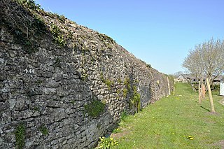
Cowbridge town wall is a Grade II*-listed medieval wall in the small market town of Cowbridge in the Vale of Glamorgan, south Wales. The walls were built by about 1300. It is believed that the purpose of the walls were to protect the Lord of Glamorgan's burgage plots and to provide a way of collecting tolls from the town's market, held twice-weekly.


