Goldsland
| |
---|---|
![]() Cattle in a field, looking across to Goldsland Wood | |
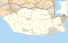
Location within the Vale of Glamorgan | |
Principal area | |
Preserved county | |
Country | Wales |
Sovereign state | United Kingdom |
Postcode district | CF |
Police | South Wales |
Fire | South Wales |
Ambulance | Welsh |
UK Parliament | |
Senedd Cymru – Welsh Parliament | |
Goldsland (Welsh : Tregold [1] ) is a small hamlet and farm in the Vale of Glamorgan in south Wales. It is located near the boundary of the Wenvoe Castle Golf Club in the parish of Wenvoe. [2] It lies to the east of Dyffryn and south of St Lythans and the road leading from the west passes through the farms of Old and New Wallace. Goldsland Brook flows through here. A sub-manor was reportedly held at Goldsland by a Mathew of Llandaff under the manor of Wenvoe in 1583. [1]
The main landmark is the Goldsland Farmhouse, with a planned farmyard dated to the early-mid 19th century and a large barn with double doors. The house is built from "narrow stone rubble with dressed stone voussoirs and quoins and Welsh slate roof". [3] The farmhouse would have supplied milk to the Jenners of nearby Wenvoe Castle.
Historically this farm appears to have reared some prized animals and gained some renown in the farming communities of Glamorgan. In 1870, E. Thomas won a prize for "Best Pair of Sows" by the Glamorganshire Agricultural Society in Cowbridge, [4] and in 1893, the owner of Goldsland Farm, Lewis Jones, foaled a horse which won first place at Glamorganshire Show at Neath and first place at the Cardiff Horse Show in 1894, amongst others. [5]
Goldsland Wood lies to the northwest of the farmhouse, an area of deciduous woodland on a low limestone ridge which spans east–west for 2.5 kilometres. [6] There are reserves of malachite here. [7]
There are several caves in the area across the ridge which have been explored as part of the University of Central Lancashire sponsored Goldsland Caves Research Project since 2005. [6] The project aims to "evaluate the chronological range of the deposits preserved in the caves; to assess the sedimentological processes involved in the formation of the deposits; to seek evidence as a basis for environmental reconstruction; and to seek evidence, in particular, of the human use of the caves in the Palaeolithic and into the Holocene and for their possible use for burial." [6] [8] The archaeologists have discovered human remains, Mesolithic and Neolithic flintwork and Neolithic pottery. [6] The main cave of Goldsland is located at 51°26′21″N3°17′00″W / 51.439062°N 3.283293°W .
Dr. Rick Peterson, the leader of the archaeological project of the university said of the findings, "The style of pottery and the flint saw-blade suggested that the remains date to around 3000 BC, which means they are over 5000 years old. We also discovered a smaller pit containing the ash from a cremation pyre, but little sign of the cremated body or any evidence where the cremation took place. Other human remains have been discovered in caves roughly around this period, from the Neolithic or New Stone Age, but almost all of them were identified years after excavation. The Goldsland caves have never been excavated before. We went there hoping to find undisturbed evidence for whatever ritual took place 5000 years ago that led to peoples’ bones being put in caves and we seem to have found it." [9]
The Vale of Glamorgan, locally referred to as The Vale, is a county borough in the south-east of Wales. It borders Bridgend County Borough to the west, Cardiff to the east, Rhondda Cynon Taf to the north, and the Bristol Channel to the south. With an economy based largely on agriculture and chemicals, it is the southernmost unitary authority in Wales. Attractions include Barry Island Pleasure Park, the Barry Tourist Railway, Medieval wall paintings in St Cadoc's Church, Llancarfan, Porthkerry Park, St Donat's Castle, Cosmeston Lakes Country Park and Cosmeston Medieval Village. The largest town is Barry. Other towns include Penarth, Llantwit Major, and Cowbridge. There are many villages in the county borough.
Until 1974, Glamorgan, or sometimes Glamorganshire, was an administrative county in the south of Wales, and later classed as one of the thirteen historic counties of Wales. Originally an early medieval petty kingdom of varying boundaries known in Welsh as Morgannwg, which was then invaded and taken over by the Normans as the Lordship of Glamorgan. The area that became known as Glamorgan was both a rural, pastoral area, and a conflict point between the Norman lords and the Welsh princes. It was defined by a large concentration of castles.
Gower or the Gower Peninsula is in South West Wales and is the most westerly part of the historic county of Glamorgan, Wales. It projects towards the Bristol Channel. In 1956, the majority of Gower became the first area in the United Kingdom to be designated an Area of Outstanding Natural Beauty.
Barry Island is a district, peninsula and seaside resort, forming part of the town of Barry in the Vale of Glamorgan, South Wales. It is named after the 6th century Saint Baruc. Barry's stretch of coast, on the Bristol Channel, has the world's second highest tidal range of 15 metres (49 ft), second only to the Bay of Fundy in Nova Scotia, Atlantic Canada.
Llantwit Major is a town and community in Wales on the Bristol Channel coast. It is one of four towns in the Vale of Glamorgan, with the third largest population after Barry and Penarth, and ahead of Cowbridge. It is 4+1⁄2 miles (7.2 km) from Cowbridge, 9 miles (14 km) from Bridgend, 10 miles (16 km) from Barry, and 15 miles (24 km) from Cardiff. It had a population of 9,530 in 2021.
Barry is a town and community in the Vale of Glamorgan, Wales. It is on the north coast of the Bristol Channel approximately 9 miles (14 km) south-southwest of Cardiff. Barry is a seaside resort, with attractions including several beaches and the resurrected Barry Island Pleasure Park. According to Office for National Statistics 2021 estimate data, the population of Barry was 56,605.
Prehistoric Wales in terms of human settlements covers the period from about 230,000 years ago, the date attributed to the earliest human remains found in what is now Wales, to the year AD 48 when the Roman army began a military campaign against one of the Welsh tribes. Traditionally, historians have believed that successive waves of immigrants brought different cultures into the area, largely replacing the previous inhabitants, with the last wave of immigrants being the Celts. However, studies of population genetics now suggest that this may not be true, and that immigration was on a smaller scale.
Wenvoe is a village, community and electoral ward between Barry and Cardiff in the Vale of Glamorgan, Wales. Nearby are the Wenvoe Transmitter near Twyn-yr-Odyn and the site of the former HTV Wales Television Centre at Culverhouse Cross which is now a housing estate. It is home to the Wenvoe Quarry and Wenvoe Castle Golf Club.
The St Lythans burial chamber is a single stone megalithic dolmen, built around 4,000 BC as part of a chambered long barrow, during the mid Neolithic period, in what is now known as the Vale of Glamorgan, Wales.
St Lythans is an affluent hamlet and former parish in the Vale of Glamorgan, southeast Wales, just outside western Cardiff. It lies southwest of Culverhouse Cross, west of Wenvoe and southwest of Twyn-yr-Odyn and is also connected by road from Dyffryn and the Five Mile Lane in the west. It is one of the wealthiest communities in the Vale of Glamorgan, containing some notable mansions and cottages, valued on average at over £500,000 as of 2011. The megalithic St Lythans burial chamber, over 6000 years old, lies 1 km to the west of the village and the hamlet also contains the St.Lythans Parish Church or Church of St Bleddian, a Grade II* listed building.
Parc Cwm long cairn, also known as Parc le Breos burial chamber, is a partly restored Neolithic chambered tomb, identified in 1937 as a Severn-Cotswold type of chambered long barrow. The cromlech, a megalithic burial chamber, was built around 5,850 years before present (BP), during the early Neolithic. It is about seven 1⁄2 miles (12 km) west south–west of Swansea, Wales, in what is now known as Coed y Parc Cwm at Parc le Breos, on the Gower Peninsula.
Parc le Breos was a great medieval deer park in the south of the Gower Peninsula, about eight miles (13 km) west of Swansea, Wales, and about 1+1⁄4 miles (2.0 km) north of the Bristol Channel. The park was an enclosed, oval area of 6.7 miles (10.8 km) in circumference, covering about 2,000 acres (810 ha) and measuring 2+1⁄2 miles (east–west) by just over 1+3⁄4 miles. Parc le Breos was established in the 1220s CE by John de Braose, Marcher Lord of Gower and husband to Margaret Ferch Llywelyn, Llywelyn Fawr's daughter. Other than for deer husbandry, the park received an income from agistment, pannage, and from sales of wild honey, ferns and dead wood. There is evidence of rabbit warrens in the park. Whether the warrens were free or domestic is unknown.
Cathole Cave, Cat Hole Cave or Cathole Rock Cave, is a cave near Parc Cwm long cairn at Parc le Breos, on the Gower Peninsula, Wales. It is a steep limestone outcrop, about 200 yards (180 m) north of the cromlech along the Parc le Breos Cwm valley and near the top of the gorge, about 50 feet (15 m) from the valley floor. The cave is a deep triangular fissure penetrating the hillside and narrowing towards the top. It has two entrances, with a natural platform outside the larger of the two. It is about seven 1⁄2 miles (12 km) west south–west of Swansea, Wales, in what is now known as Coed y Parc Cwm at Parc le Breos, on the Gower Peninsula.
Caerau Hillfort is a large triangular multivallate Iron Age hillfort, built on a previously occupied Neolithic site, occupying the western tip of an extensive ridge-top plateau in the western suburbs of Caerau and Ely, Cardiff, Wales. It is the largest Iron Age site of its type in south Wales and also one of the largest in Great Britain. The old parish church, St Mary's, and a small ringwork, almost certainly a medieval castle site probably contemporary with the church, stand within the hillfort on the north-eastern side.
Wenvoe Castle was a castle and country estate between Barry and Wenvoe, in the Vale of Glamorgan, south Wales. Today the former estate forms the Wenvoe Castle Golf Club. Goldsland lies on its western boundary.
Wrinstone or Wrinston is a medieval hamlet, just east of Wenvoe, Vale of Glamorgan, south Wales. The Wrinstone estate was variously also known as Wrenston, Wrencheston or Wrenchester. The Barry Railway line ran past the hamlet and entered the Wenvoe Tunnel just to the north near Wenvoe Quarry. It closed after a fire in 1963.
A bibliography of books related to the Vale of Glamorgan, south Wales.
Dewil Valley, located in the northernmost part of Palawan, an island province of the Philippines that is located in the Mimaropa region, is an archaeological site composed of thousands of artifacts and features. According to the University of the Philippines Archaeological Studies Program, or UP-ASP, the closest settlement can be found in New Ibajay, which is covered by the town capital of El Nido, which is located around 9 km (5.6 mi) south-east of Dewil Valley. Physically it measures around 7 km (4.3 mi) long, and 4 km (2.5 mi) wide. It is in this place which the Ille Cave, one of the main archaeological sites, can be found. It is actually a network of 3 cave mouths located at its base. It has been discovered that this site in particular has been used and occupied by humans over multiple time periods.
Ifri Oudadane is an archaeological site in the northeastern Rif region of Morocco. It is located on the southwestern coast of the Cape Three Forks on the Mediterranean Sea, and is one of the most important sites in the northwestern Maghreb region of Africa. Discovered during road construction, the site consists of a fairly large rock shelter above the modern coastline, the site has been excavated since 2006 by a team of Moroccan and German archaeologists. Although much is known about the transition of humans from hunter gatherer groups to food production in Europe and the Middle East, much of North Africa has not been researched. Ifri Oudadane is one of the first of such sites in North Africa. Dated to between 11000 and 5700 years BP, the site contains evidence that documents the shift of local inhabitants from hunter-gatherer groups to food producers. Such elements of change found at Ifri Oudadane include evidence of animal husbandry, domestication of legumes, and decoration of pottery. The site is known to contain the earliest dated crop in Northern Africa, a lentil.
The Alepotrypa Cave is an archaeological site in the Mani region of the Peloponnese peninsula. In addition to being inhabited by early farmers, this site was used for burial and cult purposes. Archaeological evidence has revealed that this is one of the largest Neolithic burial sites ever found in Europe. Two adult human skeletons were found at the site from a burial dating to the 4th millennium BC, as well as remains from at least 170 separate persons. Archaeologists are uncertain about the significance of a Mycenaen ossuary, which has been dated to the 2nd millennium BC and appears to have been reburied at Alepotrypa. While there is no direct evidence, it is possible that the ossuary may link Alepotrypa to Tainaron, which was regarded as the entrance to Hades in classical mythology.
Excavations inside a cave at Goldsland Wood, overlooking the Severn plain near Wenvoe, South Glamorgan, have uncovered remains of at least seven prehistoric people.