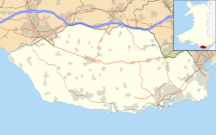
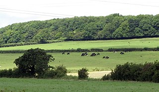
Wrinstone

Last updated
Wrinstone
Wrinstone House.jpg
Wrinstone House
Vale of Glamorgan UK location map.svg
Red pog.svg
Location within Vale of Glamorgan
General information
Town or cityWrinstone, near Wenvoe, Vale of Glamorgan
CountryWales
Coordinates 51°26′46″N3°14′39″W / 51.44611°N 3.24417°W / 51.44611; -3.24417 Coordinates: 51°26′46″N3°14′39″W / 51.44611°N 3.24417°W / 51.44611; -3.24417
Completed1880

Wrinstone or Wrinston (Welsh : Wrinstwn) is a medieval hamlet, just east of Wenvoe, Vale of Glamorgan, south Wales. The Wrinstone estate was variously also known as Wrenston, Wrencheston or Wrenchester. [1] The Barry Railway line ran past the hamlet and entered the Wenvoe Tunnel just to the north near Wenvoe Quarry. It closed after a fire in 1963.

Contents

History

A manor was held here from the early Norman period, [1] and at various points the lords of Wrinstone Manor were in control of the nearby Cwrt-yr-Ala estate and property. [2] Walter of Gloucester was known to have held Wrinstone in the mid 13th century, but by 1262 it was held by Walter de Reigny, who also held the nearby manor of Michaelston-le-Pit. [2] It was then ceded to his son Milo de Reigny. Milo's daughter, Ela (or Joan) (b. 1235), became the heiress of Wrenchester (Wrinstone)) Castle, Michaelston-le-Pit, Llantwit, and Llancarvan. Through her marriage to Simon de Raleigh, of Nettlecombe, Somerset, the Wrinstone manor passed to the de Raleighs, their descendants holding the manor for six generations. [3] Their son, also named Simon, became High Sheriff of Glamorgan in 1299, until 1304. [2] Thomas Whellesborough, heir of a Simon de Raleigh, was lord of the manor until his death in 1482. [3]

Around 1480, there were eight free tenements. Of the twelve customary tenements, one was a freeholding owned by a William Yeston of Le Grave (later Greave Farm) which was 30 acres (12 ha) in size. The other customary tenements ranged in size between 15–33 acres (6.1–13.4 ha); there were also three cottagers. [4] The manor eventually fell to the Trevelyans who sold their Welsh estates off in 1650 to pay off debts for supporting Charles I. [1] The manor briefly fell into possession of Colonel Thomas Horton's Brigade for victory at the Battle of St Fagans in 1648, who then sold it to Colonel Philip Jones of the Fonmon Estate. [1] From this date until the end of the 18th century it was under the Jones's of Fonmon and the Thomases of Wenvoe. [5] It became a township of Wenvoe after the medieval period.

In 1685 the hamlet had 20 tenements. [5] Estate plans dated to the 1760s reveal 9 houses; 5 farms and 4 cottages, grouped around a green. [5] By 1839 it had been reduced to 5 houses. [5]

Geography

Arable lands are located by Wrinstone Brook, which, along with its tributaries, drains into Cog Moors, Dinas Powys, Pablin, and the Barry Docks. [6] Wrinstone and Michaelston-le-Pit were contiguous manors. [4] The remains of a trail, roughly 4 metres wide on average, leads from the hamlet to the Church Field. [5] To the southeast is St. Andrews Major and Dinas Powys. To the northeast is a quarry and Caerau, a western suburb of Cardiff.

Notable landmarks

Farm land at Wrinstone Farm land at Wrinstone, Wenvoe - geograph.org.uk - 288557.jpg
Farm land at Wrinstone
Local countryside Countryside at Wenvoe - geograph.org.uk - 383619.jpg
Local countryside

Wrinstone House is a country house, built in 1880 on the site of the old gamekeepers cottage. It is a well-appointed stylish white house, perhaps influenced by William Burges, with two distinct turreted wings added in the 1980s, containing six additional rooms. The house contains 18 rooms in all, with 7 bedrooms and 5 bathrooms and has an outdoor swimming pool and tennis court, rare in Glamorgan. [7]

No traces of Wrinston/Wrencheston castle exist except for disturbed ground in the area of Wrinston's farm buildings. [8] It was known to have been established in the Middle Ages, but was destroyed in the early 18th century. [5] Leland documents that a while ago it was in ruin but for one high tower. [5] The hamlet also had a church, believed to have been located to the northwest of the present farm here, named "Church Field". [5] Several fragments of medieval walls have been unearthed in the vicinity, and the fragments of a side wall of a medieval building have been found built into a 6.1m by 2.1 m wall, made of limestone rubble with hard sandy mortar. [5]

Related Research Articles

<span class="mw-page-title-main">Vale of Glamorgan</span> County borough in Wales

The Vale of Glamorgan, often referred to as The Vale, is a county borough in the south-east of Wales. It borders Bridgend County Borough to the west, Cardiff to the east, Rhondda Cynon Taf to the north, and the Bristol Channel to the south. With an economy based largely on agriculture and chemicals, it is the southernmost unitary authority in Wales. Attractions include Barry Island Pleasure Park, the Barry Tourist Railway, Medieval wall paintings in St Cadoc's Church, Llancarfan, Porthkerry Park, St Donat's Castle, Cosmeston Lakes Country Park and Cosmeston Medieval Village. The largest town is Barry. Other towns include Penarth, Llantwit Major, and Cowbridge. There are many villages in the county borough.

<span class="mw-page-title-main">Barry, Vale of Glamorgan</span> Town in the Vale of Glamorgan, Wales

Barry is a town in the Vale of Glamorgan, Wales, on the north coast of the Bristol Channel approximately 9 miles (14 km) south-southwest of Cardiff. Barry is a seaside resort, with attractions including several beaches and the resurrected Barry Island Pleasure Park. According to Office for National Statistics 2016 estimate data, the population of Barry was 54,673.

<span class="mw-page-title-main">Baglan, Neath Port Talbot</span> Village in West Glamorgan, Wales

Baglan is a large village in Wales, adjoining Port Talbot, named after Saint Baglan. Baglan is also a community and ward in the Neath Port Talbot county borough. In 2001, the population was 6,654. rising to 6,819 in 2011.

<span class="mw-page-title-main">Dinas Powys</span> Human settlement in Wales

Dinas Powys is a small town and community in the Vale of Glamorgan, South Wales. Its name means "fort of the provincial place" and refers to the Iron Age hillfort which overlooks the village. Dinas Powys is 5.6 miles (9.0 km) south-west of the centre of Cardiff and is conveniently situated on the A4055 road from Cardiff to Barry, making it a popular dormitory village for city commuters. It neighbours the larger town of Penarth.

<span class="mw-page-title-main">Bonvilston</span> Human settlement in Wales

Bonvilston is a village in the Vale of Glamorgan, Wales. The village is situated on the A48 about four miles east of Cowbridge and near the Welsh capital city of Cardiff. The population in 2011 was 392.

<span class="mw-page-title-main">St. Andrews Major</span> Human settlement in Wales

St. Andrew's Major is a village and parish in the community of Dinas Powys in the Vale of Glamorgan, between Barry and Cardiff in south-eastern Wales.

<span class="mw-page-title-main">Leckwith</span> Human settlement in Wales

Leckwith is a small village in the Vale of Glamorgan, just west of Cardiff. Historically, the parish of Leckwith also included land on the east side of the river Ely that is now part of Cardiff itself. This area is also commonly known as Leckwith.

<span class="mw-page-title-main">Michaelston-le-Pit</span> Human settlement in Wales

Michaelston-le-Pit is a village in the Vale of Glamorgan, just to the west of the city of Cardiff, Wales. It is part of the Michaelston-le-Pit and Leckwith community. The community population taken at the 2011 census was 309.

<span class="mw-page-title-main">St Lythans</span> Human settlement in Wales

St Lythans is an affluent hamlet and former parish in the Vale of Glamorgan, southeast Wales, just outside western Cardiff. It lies southwest of Culverhouse Cross, west of Wenvoe and southwest of Twyn-yr-Odyn and is also connected by road from Dyffryn and the Five Mile Lane in the west. It is one of the wealthiest communities in the Vale of Glamorgan, containing some notable mansions and cottages, valued on average at over £500,000 as of 2011. The megalithic St Lythans burial chamber, over 6000 years old, lies 1 km to the west of the village and the hamlet also contains the St.Lythans Parish Church or Church of St Bleddian, a Grade II* listed building.

<span class="mw-page-title-main">Cadoxton River</span> River in United Kingdom, Wales

The Cadoxton River is a short river in the Vale of Glamorgan, South Wales and with a length of about 5 miles/8 kilometres it is one of Wales's shortest rivers.

The Vale of Glamorgan has 740 listed buildings of which 4% are Grade I listed, 10% Grade II* listed and remainder Grade II listed.

<span class="mw-page-title-main">Wenvoe Castle</span> Building in Vale of Glamorgan, Wales

Wenvoe Castle was a castle and country estate between Barry and Wenvoe, in the Vale of Glamorgan, south Wales. Today the former estate forms the Wenvoe Castle Golf Club. Goldsland lies on its western boundary.

<span class="mw-page-title-main">Fonmon</span> Human settlement in Wales

Fonmon is a hamlet in the Vale of Glamorgan in south Wales. It lies just off the B4265 road to the northwest of Font-y-Gary and Rhoose on the western side of Cardiff Airport. The hamlet is best known for its central duck pond and Fonmon Castle, a historical house located on the otherside of the B4265 road to the north. The largest house in the hamlet is called The Gables, accessed off a drive on the left approaching Fonmon from the north. A number of the houses in the area are thatched roofed.

<span class="mw-page-title-main">Goldsland</span> Human settlement in Wales

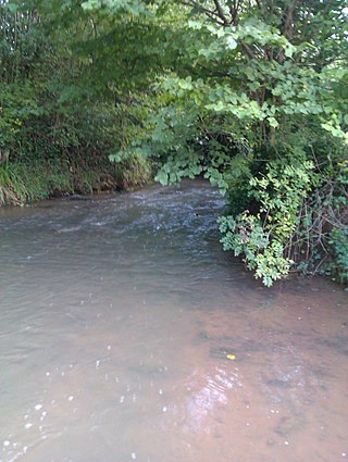
Goldsland is a small hamlet and farm in the Vale of Glamorgan in south Wales. It is located near the boundary of the Wenvoe Castle Golf Club in the parish of Wenvoe. It lies to the east of Dyffryn and south of St Lythans and the road leading from the west passes through the farms of Old and New Wallace. Goldsland Brook flows through here. A sub-manor was reportedly held at Goldsland by a Mathew of Llandaff under the manor of Wenvoe in 1583.
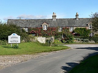
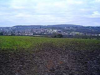
<span class="mw-page-title-main">Flemingston</span> Human settlement in Wales

Flemingston is a small village in the Vale of Glamorgan in south Wales. It is located 8.5 miles (13.7 km) northwest by road from the town centre of Barry. It contains the Church of St. Michael the Archangel, the ruins of Flemingston Court, and Flemingston Manor or Grange, all of which are listed buildings. Historically, the parish of Flemingston was a sub-manor of Aberthaw or St Athan.

<span class="mw-page-title-main">Pencoedtre</span> District of Barry in Wales

Pencoedtre or Pencoetre, also known as Pencoedtre Village, is a northeastern suburb of Barry in the Vale of Glamorgan, Wales. It borders Gibbonsdown to the southwest and Cadoxton to the south. It has developed from a small farming hamlet into an extensive housing estate in recent years. Pencoedtre Wood is one of the largest areas of woodland in the town, and is a Site of Special Scientific Interest. Pencoedtre Park is located between Pencoedtre and Gibbonsdown.

A bibliography of books related to the Vale of Glamorgan, south Wales.

<span class="mw-page-title-main">St Michael's Church, Michaelston-le-Pit</span>

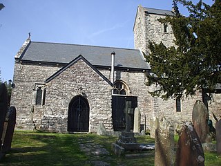
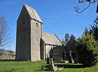
St Michael's Church is a Grade I listed church in Michaelston-le-Pit, in the Vale of Glamorgan, south Wales. It became a Grade I listed building on 28 January 1963. The church was probably built by the Reigny family; earliest records of it date to the Taxation of Norwich in 1254, where it was referred to as St Michael de Renny and was valued at four marks. The parish at one time consisted of the Manor of Michaelston-le-Pit and the church was an advowson included with the manor in the 15th and 17th centuries. By 1563, a cleric was in residence.

<span class="mw-page-title-main">Michaelston-le-Pit and Leckwith</span>

Michaelston-le-Pit and Leckwith is a community in the Vale of Glamorgan, Wales. It is located immediately southwest of the city of Cardiff and to the north of the Vale of Glamorgan villages of Llandough and Dinas Powys. As its name suggests, the community includes the small villages of Michaelston-le-Pit and Leckwith. The community population comprises only just under 250 adults.

References

  1. 1 2 3 4 Evans, Cyril James Oswald (1938). Glamorgan: Its History and Topography. W. Lewis (Printers) Limited. pp. 444–5. Retrieved 22 December 2012.
  2. 1 2 3 Royal Commission on Ancient and Historical Monuments in Wales (30 April 2000). An Inventory of the Ancient Monuments in Glamorgan: Medieval secular monuments. pt.1a. The early castles: from the Norman conquest to 1217. RCAHMW. p. 511. ISBN   978-1-871184-22-8 . Retrieved 22 December 2012.
  3. 1 2 Archaeologia Cambrensis: The Journal of the Cambrian Archoeological Association (Public domain ed.). Association. 1868. pp. 356, 359–. Retrieved 22 December 2012.
  4. 1 2 The Bulletin of the Board of Celtic Studies. Oxford University Press. 1985. pp. 179, 188. Retrieved 22 December 2012.
  5. 1 2 3 4 5 6 7 8 9 An Inventory of the Ancient Monuments in Glamorgan: Medieval Non-defensive Secular Monuments, Volume III, Part II. The Royal Commission on Ancient and Historical Monuments in Wales, Grosvenor Press. 1982. pp. 239–40. ISBN   011701141X . Retrieved 24 December 2012.
  6. Baker, Alan R. H. (1973). Field Systems British Isles. CUP Archive. pp. 500–. ISBN   978-0-521-20121-6 . Retrieved 22 December 2012.
  7. "5 Bedroom house to sleep 10 people, 10 minutes from the city of Cardiff". Vacaguru.com. Retrieved 22 December 2012.
  8. "The Manors of Michaelston-Le-Pit and Wrinstone and their early owners". Reports and Transactions (Cardiff Naturalists' Society), 1900–1981. National Library of Wales. LXV. 1932.