Listed buildings in the Vale of Glamorgan

Last updated

The Vale of Glamorgan has 740 listed buildings of which 4% are Grade I listed, 10% Grade II* listed and remainder Grade II listed. [1]

Contents

Grade II entries are listed below alphabetically by town/village.

Grade I listed buildings

Grade II* listed buildings

Grade II listed buildings

Aberthin

  • Pen-y-Bryn, Pen-y-Lan Road
  • Range of Buildings at Court Farm, Llanquian Road
  • Gatehouse and Bridge to Great House, Llanquian Road
  • The Sweetings (including attached Barn and Stable Range to West)
  • Telephone Call-Box outside “Farmers Arms” Public House
  • Glamorgan Yeomanry War Memorial, St. Hilary Down

Barry and Porthkerry

  • Watchtower at Watch House Bay
  • Rocket Station adjacent to Watch Tower
  • No. 10, Old Village Road (Rose Cottage)
  • All Saints Church, Park Road
  • Porthkerry Methodist Church, Porthkerry Road
  • Barry Hotel, Broad Street
  • No. 69 High Street
  • No. 70 High Street
  • No.71 High Street
  • No.72 High Street
  • Cenotaph, inc. area walls and steps at Gladstone Road
  • Former Fire Station, Court Road
  • Vale Resource Centre (former Polytechnic of Wales)
  • College Fields Nursing Home (former Polytechnic of Wales)
  • Springbank Nursing Home (former Polytechnic of Wales)
  • Caretaker's Cottage, ‘The Lodge’ former Polytechnic of Wales
  • Chapel of former Polytechnic of Wales
  • Municipal Buildings inc. library, (aka the Town Hall) King's Square
  • Former Church of St. Nicholas
  • Cross at former Church of St. Nicholas
  • Churchyard wall, former Church of St. Nicholas
  • Cross in Churchyard of St. Cadoc's Church
  • Cadoxton Court, Mount Pleasant
  • No. 1, Coldbrook Road East (The Old Schoolhouse)
  • Former Customs House and Mercantile Marine Office, Station Street
  • Lamp standard 1 of 6 outside former Barry Dock Offices
  • Lamp standard 2 of 6 outside former Barry Dock Offices
  • Lamp standard 3 of 6 outside former Barry Dock Offices
  • Lamp standard 4 of 6 outside former Barry Dock Offices
  • Lamp standard 5 of 6 outside former Barry Dock
  • Lamp standard 6 of 6 outside former Barry Dock Offices
  • Friars Point House
  • Gate and Gatepiers, Friars Point House
  • Lodge, Friars Point House
  • North Hydraulic Pumping House, Barry No. 1 Dock
  • Lifeboathouse adjacent to West Breakwater
  • Lifeboathouse slipway adjacent to West Breakwater
  • Walls of No. 3 Dock Basin, Barry Docks
  • Operators Cabin to Sliding Bridge
  • Breakwater Lighthouse, Barry Docks
  • Grotto in Wenvoe Castle Park

Porthkerry

  • Porthkerry Viaduct (partly in Rhoose community)
  • Lower Porthkerry Farmhouse, Porthkerry Road
  • Upper Porthkerry Farmhouse
  • Cross in Church of St. Curig
  • The Old Schoolhouse - Cottage at West end of Churchyard

Bonvilston

Broughton

  • Monkton Isaf
  • Barn with stable at Monkton Isaf

Colwinston

Corntown

  • Former Bethlehem Baptist Church (aka Ty Capel)
  • Corntown Court
  • Top Lodge
  • Village Hall
  • Corntown Farmhouse

Cowbridge

  • Nos. 1 - 3, The Butts
  • Eastfield, Cardiff Road
  • Nos. 6 and 7, Church Street
  • Gate and End Piers, Walls, Railings, Gates at West. Entrance to Churchyard
  • South-Southeast and Northwest Churchyard Walls
  • The Boot House at Grammar School, Church Street
  • SE Wall to Former Grammar School Garden, Church Street
  • No.18 (East House), Eastgate
  • Telephone Call-Box beside Eastgate Mews, Eastgate
  • No. 44 (Ancient Druid), Eastgate
  • No. 46 (The Armoury), Eastgate
  • No. 48 (East Villa), Eastgate
  • No. 49 Eastgate
  • No. 54 (Heath House), Eastgate
  • Nos. 56 and 58, Eastgate
  • Telephone Call-Box outside Royal Mail Delivery Office, Eastgate
  • No. 66 (Colours), Eastgate
  • No. 68 (Eastgate Gallery), Eastgate
  • No. 70, Eastgate
  • Nos. 71 & 73, Eastgate
  • No. 77 Eastgate
  • No. 79 (Citizens’ Advice Bureau)
  • No. 1 (‘Aberthaw’/ ‘Glanthaw’) including forecourt wall and railings), High Street
  • No. 16 High Street
  • No. 18 High Street
  • No. 20 High Street
  • No. 22 High Street
  • No. 23 High Street
  • Water Pump against SE Elevation of No. 23, High Street
  • Telephone Call-Box outside No. 23, High Street
  • No. 26 High Street
  • No. 27 High Street
  • Mounting Block attached to Nos. 25 & 27 High Street
  • No. 28 (Principality Building Society), High Street
  • No. 29 High Street
  • No. 30 (Ogmore Vale Bakery), High Street
  • No. 31 High Street
  • No. 33 (Lloyds Bank), High Street
  • Former Coach House to rear of Nos. 34 & 36, High Street
  • Nos. 35, 35a & 35b, High Street
  • Nos. 36-38 (Woodcocks and W. G. Davies), High Street
  • Nos. 40-42 High Street
  • No. 39 (Xantippe), High Street
  • No. 41 (Lloyds Chemist), High Street
  • No. 43 High Street
  • No. 48 (Duke of Wellington PH - including Rear Wing to Church Street), High Street
  • No. 50 High Street II
  • Nos. 51 & 53 (Vale of Glamorgan Public House), High Street
  • No. 52 High Street
  • No. 54 (Farthings Old Wine House), High Street
  • No. 55 (Roddam Travel & Watts Morgan), High Street
  • No. 56 High Street
  • No. 58 High Street
  • No. 60 (Former High Street Garage)
  • No. 61 (HSBC (Midland Bank)), High Street
  • No. 62 (Barclays Bank), High Street
  • The Old Hall, High Street
  • No. 63 (The Bear Hotel), High Street
  • No. 66 (Ye Olde Mason's Arms PH), High Street
  • No. 77 (Llwyn Celyn), High Street
  • No. 81 High Street
  • No. 83 (Woodstock House), High Street
  • Northwest Boundary Wall to No. 83, High Street
  • War Memorial in front of Town Hall, High Street
  • The Old Brewery Building, High Street
  • Building to rear of Town Hall, Town Hall Square
  • Northwest Garden Wall to Rose Cottage and Southwest Garden Walls to Old Hall & Grammar School Garden Southeast, Town Mill Road
  • Rose Cottage, including forecourt garden walls, Town Mill Road
  • The Poplars, including garden walls and gate, Town Mill Road
  • Telephone Call-Box outside Hill View & The Haven, Westgate
  • Nos. 1 & 3, Westgate
  • No. 4 (National Westminster Bank), Westgate
  • No. 21, Westgate
  • United Free Church (Ramoth Chapel), Westgate
  • No. 34, Westgate
  • Water Pump near Police Station, Westgate
  • Police Station, Westgate

Cwm Cidy

  • No 1. Cwm Cidy Farm
  • No 2. Cwm Cidy Farm
  • No. 3 Cwm Cidy Farm
  • Cwm Cidy Farm Cottage

Dinas Powys

  • Remains of Dinas Powys Castle, off Lettons Way, Dinas Powys
  • Downs Farmhouse, Sully Road (Prev. recorded under 22.02.00)
  • Dinas Powys Parish Hall, Britway Road, Dinas Powys
  • Church of St. Peter, Mill Road, Dinas Powys
  • The Mount, Mount Road, Dinas Powys
  • Old Court, The Square (aka The Twyn), Dinas Powys
  • War Memorial, The Square (aka The Twyn), Dinas Powys
  • Lon Twyn, Twyncyn, Dinas Powys
  • Biglis Farmhouse, off Argae Lane, Dinas Powys
  • Barn at Biglis Farm, Dinas Powys
  • Little Orchard (nos 1-6), Murch, Dinas Powys

East Aberthaw

Ewenny

  • Garden Gateway with gates and attached wall at Ewenny Priory (House)
  • Garden wall linking North and South Gatehouses at Ewenny Priory (House)
  • Northeast Precinct Wall at Ewenny Priory (House)
  • Stable Court East range at Ewenny Priory (House)
  • Stable Court North range at Ewenny Priory (House)
  • Stable Court West range at Ewenny Priory (House)
  • Barn on Ewenny Down
  • Lampha Court and attached barn range
  • Barn and attached ranges at Wallas Farm

Fonmon

  • Stables of Fonmon Castle
  • Walls of walled gardens at Fonmon Castle
  • Retaining walls of South Gardens at Fonmon Castle
  • East Hall (aka ‘Rosedene’)
  • Walls surrounding Fonmon Pond inc. bridge and weir and wells
  • Fonmon Well

Leckwith

  • Brynwell Farmhouse – Including attached agricultural buildings

Llanblethian

  • Roadside Cross, Church Road
  • Breach Farm House, Llantwit Major Road
  • Kingscombe, Llanmihangel Road
  • Llanblethian House and No. 2, including Forecourt, Walls & Railings Church Road
  • Telephone Call-Box, Bridge Street, near Brook Cottage

Llancadle

Llancarfan

  • Telephone Call-Box between Parish Hall and the bridge

Michaelston-le-Pit

  • Telephone Call-Box by Church Cottages
  • 1,2,& 3 Church Cottages
  • Lychgate at Church of St. Michael
  • Cwrt yr Ala House
  • The Old Dairy at Cwrt yr Ala House

Outlying

  • Barn at Garn-Llwyd
  • Llanfythin Farmhouse
  • Gatehouse at Llanfythin Farmhouse
  • Llanfythin Mill
  • Circular Pigsty at ‘The Meadows’ ( Formerly Tre-Aubrey House)
  • Llanfythin Mill House

Llandough, Llanfair

  • Church of St. Dochdwy
  • Llandough Castle Flats
  • Northeast, Southeast, and Southwest walls, gatepiers and railings enclosing Llandough Castle and Gatehouse
  • Village Hall
  • The Rectory

Llandough, Penarth

  • St. Dochdwy's Church
  • Former National School and School House at No. 2 Lewis Road
  • Pound Cottage
  • Barons Court Public House and Restaurant

Llandow

  • Great House
  • Barn to East of Great House
  • Ty Fry Farmhouse
  • The Rectory

Llanfrynach

  • Cross base in churchyard of Church of St Brynach

Llangan

  • Church of St. Canna, Llangan
  • Church of St. Mary, St. Mary Hill
  • Telephone Call-Box opposite Mount Pleasant Farm, Llangan
  • Churchyard Cross at Church of St. Mary, St. Mary Hill
  • Churchyard Wall at Church of St. Mary, St. Mary Hill
  • Cross Base at Village Farmhouse St. Mary Hill
  • Saron Welsh Congregational Chapel, Treoes
  • Chimney 100m North of Gelliaraul Farmhouse
  • Mount Pleasant Farmhouse with attached barn
  • The Old Rectory
  • Pantruthin-fach Farmhouse
  • Cowshed at Pantruthin-fach Farm
  • The Star Inn, P.H.Treoes
  • Treoes Farmhouse

Llanmaes

  • Cross in Churchyard of Church of St. Cattwg (Llanmaes Church)
  • Railed Tomb to Nicholl Family E of Chancel at Church of St. Cattwg
  • Dovecot at Llanmaes House (Great House)
  • Plaisted House
  • Plaised Cottage
  • Telephone Call-Box North of village centre (set away from road)
  • Barn at Great House Farm
  • ‘Picketston’, Picketston

Llanmihangel

  • Terrace and steps at Yew Tree Pleasance, Plas Llanmihangel
  • St. Anne's Well
  • Rectory Farm

Llansannor

  • Barn at Court Farm
  • Cross in Churchyard of Church of St. Senwyr
  • Westwing of Llansannor Court
  • The Cottage Llansannor Court
  • Former Cartshed and Granary at Court Farm
  • Is-y-coed Farmhouse
  • Llansannor House
  • The Old Rectory

Llantrithyd

  • Ruins of Llantrithyd Place
  • Telephone Call-Box, North of Parish Church
  • Ty Draw Farmhouse
  • Agricultural outbuildings Ty Draw Farm

Llantwit Major and Boverton

  • Churchyard Cross, Church Street
  • Churchyard walls and gates to St. Illtud's Church, Burial Lane
  • Mid Well, Bakers Lane
  • Circular Walls and Steps at West End Pond
  • Batslays Farmhouse
  • Boverton Park House (Prev. Boverton Place Farmhouse)
  • Boverton Place
  • ‘The Causeway’ (Prev. No. 4. The Causeway and “Navron”)
  • ‘Navron’ (Prev. No. 4. The Causeway and “Navron”)
  • Walls surrounding garden to West of Boverton House (Prev. doorway and walls of garden to West of Boverton House)
  • Boverton House and attached stable block
  • Garden Walls and railings of Boverton House
  • Wall and Gateway Opposite Boverton House
  • Cherry Tree Cottage (Prev. Nos. 1 and 2, Boverton Court Farm or Boverton Court Cottage)
  • Tudor Cottage (Prev. Nos. 1 and 2, Boverton Court Farm or Boverton Court Cottage)
  • Orchard House
  • Former Chantry Priest's House, Burial Lane
  • Chantry House, Hillhead
  • Old Place or Llantwit Major Castle
  • Forecourt Wall of Old Place
  • Old Plas Cottage, West Street
  • Well opposite Downcross Farm, West Street
  • Downcross Farmhouse, Including Front Garden Wall (Prev. Downcross Farm, West Street)
  • Footbridge over stream, West entrance to St. Illtud's Churchyard, Church of St. Illtud
  • Tudor Tavern Public House
  • 1 Church Street (Prev. Nos. 1 and 1A, Church Street)
  • Quaintways with attached garden wall (Prev. Ty Ny and Southern wing of Quaintways, Colhugh Street)
  • Ty Ny with attached garden wall (Prev. Ty Ny and Southern wing of Quaintways, Colhugh Street)
  • To-Hesg (Prev. Ty Hesg) Colhugh Street
  • Old Rosedew House (Prev. Rosedew, Colhugh Street)
  • Rosedew, Colhugh Street
  • Bethel Baptist Church, Commercial Street
  • The Old House, Court Close (Prev. House to Northeast of Pear Tree Cottage, High Street)
  • Plymouth House, Plymouth Street (Prev. Plymouth House (including mounting block))
  • Garden Wall, Gate and Mounting Block and Stables at Plymouth House
  • Lodge to Dimlands (Prev. Dimlands House) Dimlands Road
  • Tyle House
  • Bethesda’r Fro Chapel with attached mounting block Eglwys Brewis Road
  • Forecourt and Graveyard Gates, Gatepiers and Walls of Bethesda’r Fro Chapel Eglwys Brewis Road
  • Malta House, 1 Flanders Road
  • 2 Flanders Road
  • The Cottage with attached Garden Walls, 4 Flanders Road (Prev. Nos. 3 and 4, Flanders Road)
  • Flanders Farmhouse, Flanders Road
  • Garden Wall and Gate of Flanders Road
  • Lower House (Prev. Lower House Farm) Flanders Road
  • Great Frampton
  • Barn and Stable Range at Great Frampton Farmhouse
  • Court House, High Street
  • Sunny Bank, with attached Garden Walls, High Street
  • Outhouse at Sunnybank
  • The Old Police Station, Hillhead
  • Little Frampton Farmhouse
  • Brooklands Cottage, Methodist Lane
  • Summerhouse Fort, Summerhouse Camp
  • Summerhouse Tower, Summerhouse Camp
  • Fonmon Cottage (Prev. Fonmon House) Station Road
  • War Memorial, (Formerly base of war memorial)The Square
  • Telephone Call-Box, Outside Old White Hart Public House
  • Pear Tree Cottage with attached wall and mounting block (Prev. Corner House and Pear Tree Cottage [including mounting block], Turkey Street)
  • Corner House (Prev. Corner House and Pear Tree Cottage [including mounting block], Turkey Street)
  • Rewley Court (Prev. Rawley Court) Turkey Street
  • West Farm, West St. (Prev. West Farmhouse and garden walls)
  • Front Garden Wall to West Farm
  • Walls to [detached] garden to West Farm on SE side of West Street
  • Hill Cottage, West Street
  • Swimbridge Farmhouse, with attached garden walls, Westhill Street
  • The Swine Bridge, Westhill Street
  • Downs Farmhouse, Wick Road
  • Circular Pigsty, Downs Farm, Wick Road
  • Windmill House (Prev. Frampton Windmill) Windmill Lane
  • Old White Hart Inn Public House, Wine Street
  • The Old School, including attached walling, Wine Street (Prev. The Old Rectory- (Formerly Presbytery and Llanilltud Fawr County Junior School))

Llysworney

  • Church of St.Tydfil
  • Llysworney House (Great House)
  • The Old Sheep Washery
  • Former Church School
  • Former Ebenezer Particular Baptist Church
  • Milepost at the Carne Arms Public House

Nash

  • Pheasant House, Nash Manor
  • Pigeon House, Nash Manor

Old Beaupre

  • Former Hall Range to South of Old Beaupre Castle
  • Old Beaupre Barn

Peterston-super-Ely

  • Llanwensan Fawr Farmhouse
  • Telephone Call-Box, outside Fircot
  • Croes-y-Parc Baptist Chapel [see also 16.20]
  • Road Bridge over Nant Criafol
  • 1 Pwll y Min Crescent
  • 2 Pwll y Min Crescent
  • 3 Pwll y Min Crescent
  • 4 Pwll y Min Crescent
  • 5 Pwll y Min Crescent
  • 6 Pwll y Min Crescent
  • 7 Pwll y Min Crescent
  • 8 Pwll y Min Crescent
  • 9 Pwll y Min Crescent
  • 10 Pwll y Min Crescent
  • 4 & 6 Cory Crescent
  • 8 & 10 Cory Crescent
  • 16 & 18 Cory Crescent
  • Rectory House (aka ‘The Old Rectory’)
  • Monument to Dafydd Williams Croes y parc Baptist Chapel

Penarth and Cogan

See also Listed buildings in Penarth
  • No. 41, Albert Road, (Former Post Office now restaurant)
  • Pillar Box outside Post Office, Albert Road
  • Albert Road County Infants’ School
  • School House at No. 17 Albert Road
  • Telephone Call-Box, on the edge of Albert Road Gardens
  • Cenotaph, Alexandra Park
  • No. 20 Archer Road
  • No. 22 Archer Road
  • No. 24, Archer Road, (see also 25, Victoria Road)
  • North Lodge, (Piermaster's lodge) Windsor Gardens, Bridgeman Road
  • Remains of Cwrt-y-Vil Grange (Castle), 2 Castle Avenue
  • Telephone Call-Box at the corner of Church Avenue and Clive Place
  • Footbridge (Cogan Station), Cogan Hill
  • Customs House, Dock Road
  • Marine Buildings, Dock Road
  • Inn at the Deep End, Esplanade
  • Telephone Call-Box, in front of Pavilion and Pier
  • Penarth Pier, including Pavilion and Shops
  • Coastguard Cottage, No. 2, Marine Parade (see also Nos. 1-5 Tower Hill Avenue)
  • No. 13 Marine Parade (Greylands)
  • No. 14 Marine Parade (Leigh Holme)
  • Headlands School, Paget Place
  • No. 2, Plymouth Road
  • No. 4, Plymouth Road
  • Nos. 6, Plymouth Road
  • Nos. 8, Plymouth Road
  • Nos. 10, Plymouth Road
  • Turner House Gallery, Plymouth Road
  • Telephone Call-Box close to junction with Stanwell Road
  • Public Library, Stanwell Road
  • Trinity Methodist Church, Stanwell Road
  • Church Hall, adj. Trinity Methodist, Stanwell Road
  • Telephone Call-Box outside Nos. 5 and 5a, Royal Buildings, Station Approach
  • No. 1 (of 5), Tower Hill Avenue
  • No. 2 (of 5), Tower Hill Avenue
  • No. 3 (of 5), Tower Hill Avenue
  • No. 4 (of 5), Tower Hill Avenue
  • No. 5 (of 5), Tower Hill Avenue (see also No. 2 Coastguard Cottage, Marine Parade)
  • Paget Rooms, Victoria Road
  • No. 20, Victoria Road
  • No. 22, Victoria Road (St Margarets)
  • No. 25, Victoria Road (see also No. 24 Archer Road)
  • No. 60, The Red House, Victoria Road
  • All Saint's Parish Hall, Victoria Square
  • Windsor Arcade Building
  • Lloyd's Bank, Windsor Road
  • Woodland Hall, Woodland Place
  • St. Joseph's Church, Wordsworth Avenue
  • St. Joseph's Presbytery, Wordsworth Avenue
  • ‘Sea Roads’ Cliff Parade

Pendoylan

  • Pendoylan Cottages
  • Telephone Call-Box at Heol St. Cattwg (North Side)
  • Cae’r Wigau Isaf
  • Cae’r Wigau Uchaf
  • Duffryn Mawr Farmhouse
  • Hensol Bridge
  • Hafod Lodge to Hensol Castle, (also known as Bottom Lodge)
  • Llwyn Rhyddid
  • Ty Fry Lodge

Penllyn

  • Great House [Formerly Great House Farmhouse]
  • Penllyn Castle
  • The Lodge Cottage, Penllyn Castle
  • The Cottage, ‘Penllyn Cottage’, Penllyn Castle
  • Gatepiers, gates and boundary walls at entrance to Penllyn Castle
  • Village Farmhouse
  • Easternmost Salmon Well
  • Central Salmon Well
  • Westernmost Salmon Well
  • Church of St John the Evangelist
  • The Old School House

Penmark

  • Cross in churchyard of Church of St. Mary
  • Casberd family tomb in churchyard of Church of St. Mary
  • Memorial to John and Mary Jenkins in churchyard of Church of St. Mary
  • Sarah Elizabeth Jones Memorial Cross in churchyard of Church of St. Mary
  • Kenson Bridge
  • Telephone Call-Box at centre of village / corner of Croft John

Peterston-super-Ely

  • Llanwensan Fawr Farmhouse
  • Telephone Call-Box, outside Fircot
  • Croes-y-Parc Baptist Chapel [see also 16.20]
  • Road Bridge over Nant Criafol
  • 1 Pwll y Min Crescent
  • 2 Pwll y Min Crescent
  • 3 Pwll y Min Crescent
  • 4 Pwll y Min Crescent
  • 5 Pwll y Min Crescent
  • 6 Pwll y Min Crescent
  • 7 Pwll y Min Crescent
  • 8 Pwll y Min Crescent
  • 9 Pwll y Min Crescent
  • 10 Pwll y Min Crescent
  • 4 & 6 Cory Crescent
  • 8 & 10 Cory Crescent
  • 16 & 18 Cory Crescent
  • Rectory House (aka ‘The Old Rectory’)
  • Monument to Dafydd Williams Croes y parc Baptist Chapel

Rhoose

  • Lower Farmhouse Fontygary Road
  • Lower Farm Cottage and attached garden wall, Brendon View Close
  • Rhoose Council School, Fontygary Road

Cwm Ciddy

  • No 1. Cwm Cidy Farm
  • No 2. Cwm Cidy Farm
  • No. 3 Cwm Cidy Farm
  • Cwm Cidy Farm Cottage

East Aberthaw

Fonmon

  • Stables of Fonmon Castle
  • Walls of walled gardens at Fonmon Castle
  • Retaining walls of South Gardens at Fonmon Castle
  • East Hall (aka ‘Rosedene’)
  • Walls surrounding Fonmon Pond inc. bridge and weir and wells
  • Fonmon Well

Lower Porthkerry

  • Lower Porthkerry Farmhouse, Porthkerry Road
  • Upper Porthkerry Farmhouse

Porthkerry

  • Cross in Church of St. Curig
  • The Old Schoolhouse - Cottage at West end of Churchyard
  • Porthkerry Viaduct (partly in Barry community)

Sigingstone

St Andrews Major

  • Churchyard Cross, St Andrews’ Churchyard, St. Andrews Major
  • The Bier House, St Andrews’ Churchyard, St. Andrews Major
  • Garn Hill and attached Garden Terrace, St. Andrews Major
  • 1 Little Orchard, Murch
  • 2 Little Orchard, Murch
  • 3 Little Orchard, Murch
  • 4 Little Orchard, Murch
  • 5 Little Orchard, Murch
  • 6 Little Orchard, Murch

St Athan

St. Athan

  • Anonymous Monument and railings in Churchyard of Church of St Athan
  • St Athan War Memorial
  • The Old Rectory (Balfour House)
  • Myrtle Cottage and out buildings
  • West Farmhouse
  • West Orchard Farmhouse
  • Aderyn [Prev. part of West Orchard Farmhouse]

Castleton

  • Bakehouse and Donkey Stable at Castleton Farmhouse
  • Former Barn at Castleton Farm

East Orchard

  • Retainers Hall at East Orchard [part remains of East Orchard Castle]
  • Dovecote at East Orchard [part of remains of East Orchard Castle]

Eglwys Brewis

  • Church of St. Brise

Flemingston

  • Detached Kitchen at Flemingston Court
  • Garden Wall and House Ruins at Flemingston Manor
  • Combination farm buildings at Flemingston Court Farm
  • Telephone Call-Box North of parish church
  • Gregory Farm / Yr Hen Fferm Dy

Gileston

  • Cross in Churchyard of Church of St Giles
  • Stable Block at Gileston Manor
  • Cheesehouse at Gileston Manor
  • Walls and attached Summerhouse of Walled Gardens at Gileston Manor
  • Pigsty at Gileston Manor
  • Garden Walls along Roadside at Gileston Manor
  • Kitchen Garden Wall at Gileston Manor
  • Rose Cottage
  • Telephone Call-Box at road junction in centre of the village

West Aberthaw

  • West Aberthaw Farmhouse
  • Garden Wall of West Aberthaw Farmhouse
  • Barn at West Aberthaw Farm
  • Cart Shed at West Aberthaw Farm
  • Bull House (Old Chapel) at West Aberthaw Farm
  • Heavy Horse Stable at West Aberthaw Farm

St Brides Major

Ogmore by Sea

  • Ogmore Farm
  • Stables at Ogmore Farm
  • Old Star Cottage
  • Barn at Ty Maen
  • Sutton

St. Brides Major

  • Bryn Sion Presbyterian Chapel
  • Pen-ucha’r Dre Farmhouse
  • Castle upon Alun House and garden walls to South and East
  • Former Byre at Castle upon Alun
  • Cartshed, Castle upon Alun
  • Churchyard Cross Church of St. Bridget
  • The Old Vicarage
  • Blackhall Farm
  • Bee Boles at Blackhall Farm
  • Clapper Bridge
  • Pont Groes Gwta
  • Barn and Cow Houses at Pen Ucha Dre

Dunraven Park

  • Grand Lodge
  • Former Ice Tower and Banqueting Hall
  • Boundary and Dividing Walls to Walled Garden
  • Garden Building
  • Entrance gateway with Flanking Wall at Dunraven House
  • Boundary Wall and Entrance gate to S of Seamouth Lodge
  • Seamouth Lodge
  • Boundary Wall North of Seamouth Lodge
  • Slade

Durval

  • Seamouth Cottage
  • Dovecot at Durval Farm
  • Fynnon y Winch [pump house]

Heol y Mynydd

  • Fynnon y Pant
  • Evergreen Cottage

Southerndown

  • Sunshine House
  • Clifton House and the Link

St. George’s Super-Ely

St. Bride’s

  • St.-y-Nyll Windmill Tower and Barn remains
  • Church of St. Ffraid St. Bride's
  • St-y-Nyll

St. George’s

  • Churchyard Cross at Church of St. George
  • Church Cottage
  • Ty Ffynnon

Coedarhydyglyn

  • Gate and Gatepiers, midway along South drive, Coedarhydyglyn
  • Gate and Gatepiers beside South Lodge, Coedarhydyglyn

St. Hilary

  • Churchyard cross, Church of St. Hilary
  • Bassett Family Tomb Enclosure, Church of St. Hilary
  • The Bush Inn
  • Pigsty in garden of Church Cottage
  • No 1 Manor Cottages (Prev. Nos. 1 and 2, Manor Cottages)
  • No. 2 Manor Cottages
  • The Manor
  • Village Farm
  • Telephone Call-Box opposite Village Farm
  • The Cottage
  • New Beaupre

St. Mary’s Church

  • Church of St. Mary
  • Church Cottage, (aka Old Rectory)
  • Fishweir Farmhouse
  • Barn at Fishweir

St. Nicholas

  • Fountain to South of Dyffryn House
  • Pompeian Garden, Dyffryn House
  • Walled Garden, Dyffryn House
  • Lower South Terrace at Dyffryn Gardens
  • Vine Walk and Kiosks, Dyffryn Gardens
  • Cory Family chest-tomb at Church of St. Nicholas
  • No. 3 Smiths Row (Blacksmith Cottages)
  • No. 4 Smiths Row (Blacksmith Cottages)
  • No. 5 Smiths Row (Blacksmith Cottages)
  • The Three Tuns
  • Telephone Call-Box, A48 (North side) on approach to Church
  • GPO pillar box, A48 (North side) on approach to Church
  • St. Nicholas Church Hall
  • St. Nicholas Church Hall House
  • Cottrell Lodge

St Donats

St Donats

  • Churchyard Wall of Church of St Donat's inc. railings and Gate
  • Nicholl-Carne Memorial Cross in Churchyard of Church of St Donat's
  • Cottage against Southeast Churchyard wall - Church of St Donat's
  • The Old Rectory
  • Wall of entrance forecourt at St Donat's Castle and part of Northwest Boundary Wall
  • Walls of entrance forecourt flanking the bridge at St. Donat's Castle
  • Staff house in NE corner of the entrance forecourt
  • Music Dept at Atlantic College (Prev. Former Coach House at Castle)
  • Former forecourt stables at St Donat's Castle
  • St. Donat's Arts Centre (Prev. Tithe Barn at St. Donat's Castle)
  • Art Department of Atlantic College
  • Walls, Steps, Terraces, Pavilion, Summerhouse and cottage attached to the wall of the hanging gardens
  • Sundial at St Donat's Castle
  • The Cavalry Barracks
  • Sea walls and towers at St Donat's Castle
  • Watchtower to West of St Donat's Castle
  • Top (East) Lodge to St Donat's Castle inc. attached garden wall
  • North Lodge to St Donat's Castle
  • East Boundary Wall of St Donat's Castle
  • Cartref
  • Splott Farmhouse and adjoining Granary Wing

Marcross

  • Churchyard wall, gatepiers and gates, to church of holy trinity running along the road
  • Sundial in churchyard of Church of the Holy Trinity
  • High wall comprising remains of Marcross Castle, bounding part of Southwest farmyard of Village Farm
  • Freestanding outbuilding at Village Farm incorporating remains of Marcross Castle and sited on Southwest

Monknash

  • Church Farmhouse
  • Garden wall of Church Farmhouse
  • Outhouse range to South of Church Farmhouse
  • Dovecot at Monknash Grange (Prev. Remains of medieval dovecote)
  • Monknash Forge
  • Plough and Harrow Public House inc. front garden walls

Nash Point

Sully

  • Church of St John the Baptist ‘Sully Church’
  • Former Lodge & Screen Walls flanking driveway entrance to Sully Hospital
  • Cog House [formerly Cog Farm including buildings and eight Rickstands]
  • Planned Group of farm buildings at Cog Farm
  • Eight Rickstands at N Side of Cog Farm
  • Hayes Farm Windmill
  • Church of St. Lawrence
  • Limekiln, Ashby Road
  • Barn at Home Farm
  • Swanbridge House, St Mary's Well Bay Road

Sutton

Walterston

  • Walterston Fach Farmhouse
  • Barn at Trewallter Fawr

Wenvoe

  • Telephone Call-Box on village green, Wenvoe
  • Nant Bran Farmhouse
  • Agricultural Range opposite Nant Bran Farmhouse
  • Outbuildings to North of Nant Bran Farmhouse
  • Former Bull Shed at Nant Bran Farm
  • The Old Rectory
  • Former Coach House and Stables at Wenvoe Castle
  • Former Walled Kitchen garden wall at Wenvoe Castle – West Range
  • Barn at Goldsland Farm
  • Well House, Dyffryn Gardens
  • Lidmore Farmhouse
  • Lower South Terrace at Dyffryn Gardens
  • Lions Steps, Dyffryn Gardens
  • Fountain to South of Dyffryn House
  • Vine Walk and Kiosks, Dyffryn Gardens

Welsh St Donats

Wick

  • Remains of Preaching Cross St James’ Church, Church Street
  • Ruined Windmill Tower [off Church Street]
  • Primrose Cottage, Church Street
  • Bluebell Cottage, Church Street
  • Lamb Cottage, Church Street
  • Sycamore House, Church Street
  • Brooks Farm and adjoining range, West Street
  • Farm Range to NE of Brooks Farm
  • Cow House and stable range to NE Brooks Farm

Green Isaf

  • Green Isha Farm with adjoining Stable and Dovecot
  • Yr Hen Felin Wynt, Green Isaf

Trepit

  • Trepit Cottage, Trepit.

Picket

  • Mill, Threshing Barn and Cart Shed at Church Farm
  • Outbuilding at Church Farm [1]
  • Outbuilding at Church Farm [2]
  • Outbuilding at Church Farm [3]
  • Outbuilding at Church farm [4]

Ystradowen

  • Church of St Owain
  • Churchyard Wall and Gates of Church of St Owain
  • Llwynhelig House

See also

Related Research Articles

<span class="mw-page-title-main">Llantwit Major</span> Human settlement in Wales

Llantwit Major is a town and community in Wales on the Bristol Channel coast. It is one of four towns in the Vale of Glamorgan, with the third largest population after Barry and Penarth, and ahead of Cowbridge. It is 4+12 miles (7.2 km) from Cowbridge, 9 miles (14 km) from Bridgend, 10 miles (16 km) from Barry, and 15 miles (24 km) from Cardiff. It had a population of 9,530 in 2021.

<span class="mw-page-title-main">Aberthaw</span> Human settlement in Wales

Aberthaw is an area containing the villages of East Aberthaw and West Aberthaw, on the coast of South Wales about 5 miles (8 km) west of Barry. It is home to Aberthaw Cement Works, Aberthaw Lime Works, and Aberthaw Power Station, a decommissioned coal power station that was linked to the South Wales Valleys via the Vale of Glamorgan Railway. The area is historically within the parish of Penmark in the Vale of Glamorgan. The two villages of West and East Aberthaw are separated by the River Thaw. The village of East Aberthaw, near Rhoose, has a 13th-century pub. The village Baptist Chapel and Mission Room no longer exist as such and have been converted for other uses.

<span class="mw-page-title-main">Fonmon Castle</span>

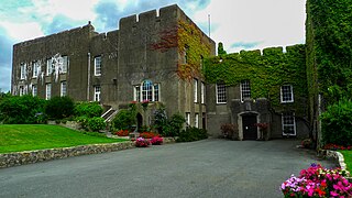
Fonmon Castle is a fortified medieval castle near the village of Fonmon in the Vale of Glamorgan and a Grade I listed building. The castle's gardens are designated Grade II on the Cadw/ICOMOS Register of Parks and Gardens of Special Historic Interest in Wales. With its origins rooted in the 12th century it is today seen as a great architectural rarity, as it is one of few buildings that was drastically remodelled in the 18th century, but not Gothicized. The castle is believed to have remained under the ownership of just two families throughout its history; from Norman times, it was owned by the St Johns, and from 1656, by the descendants of Colonel Philip Jones.

<span class="mw-page-title-main">Listed buildings in Christchurch, Dorset</span>

Christchurch is a town and former borough in the county of Dorset on the English Channel coast, adjoining Bournemouth in the west, with the New Forest to the east. Historically in Hampshire, it joined Dorset with the reorganisation of local government in 1974 and is the most easterly borough in the county. Its close proximity to the Cotentin Peninsula made it an important trading port and a potential target for invasion during the Napoleonic and Second World Wars.

<span class="mw-page-title-main">Flemingston</span> Human settlement in Wales

Flemingston is a small village in the Vale of Glamorgan in south Wales. It is located 8.5 miles (13.7 km) northwest by road from the town centre of Barry. It contains the Church of St. Michael the Archangel, the ruins of Flemingston Court, and Flemingston Manor or Grange, all of which are listed buildings. Historically, the parish of Flemingston was a sub-manor of Aberthaw or St Athan.

<span class="mw-page-title-main">Grade II* listed buildings in Mendip</span>

Mendip is a local government district in the English county of Somerset. The Mendip district covers a largely rural area of 285 square miles (738 km2) ranging from the Mendip Hills through on to the Somerset Levels. It had a population of approximately 110,000 in 2014. The administrative centre of the district is Shepton Mallet.

<span class="mw-page-title-main">Grade I listed buildings in the Vale of Glamorgan</span>

There are 33 Grade I listed buildings in the Vale of Glamorgan all of which are churches and priory buildings, castles, country or manor houses and associated structures such as churchyard crosses and a dovecote.

<span class="mw-page-title-main">Grade II* listed buildings in Monmouthshire</span> List of buildings in principal area of Wales

Monmouthshire is a county of Wales. It borders Torfaen and Newport to the west; Herefordshire and Gloucestershire to the east; and Powys to the north. The largest town is Abergavenny, with the other major towns being Chepstow, Monmouth, and Usk. The county is 850 km2 in extent, with a population of 95,200 as of 2020. The present county was formed under the Local Government (Wales) Act 1994, which came into effect in 1996, and comprises some sixty percent of the historic county. Between 1974 and 1996, the county was known by the ancient title of Gwent, recalling the medieval Welsh kingdom. In his essay on local government in the fifth and final volume of the Gwent County History, Robert McCloy suggests that the governance of "no county in the United Kingdom in the twentieth century was so transformed as that of Monmouthshire".

Worsthorne-with-Hurstwood is a civil parish in the borough of Burnley, Lancashire, England. The parish contains 22 buildings that are recorded in the National Heritage List for England as designated listed buildings. Of these, four are listed at Grade II*, the middle grade, and the others are at Grade II, the lowest grade. Apart from the village of Worsthorne and the settlement of Hurstwood, the parish is rural. Most of the listed buildings are farmhouses, or originated as farmhouses or farm buildings. Other listed buildings include large houses and associated structures, a row of former back-to-back cottages, a church, and a telephone kiosk.

Up Holland is a civil parish in the West Lancashire district of Lancashire, England. It contains 97 buildings that are recorded in the National Heritage List for England as designated listed buildings. Of these, one is listed at Grade I, the highest of the three grades, four are at Grade II*, the middle grade, and the others are at Grade II, the lowest grade. The parish contains the village of Up Holland and surrounding countryside. The oldest surviving structure in the parish is Up Holland Priory, the chancel of which was converted into the nave of the Church of St Thomas the Martyr; both of these are listed. Most of the other listed buildings are houses, cottages and associated structures, and buildings that are farmhouses and farm buildings. The Liverpool and Bury Railway Company built a railway through the parish and, associated with this and listed, are two bridges and two tunnel portals. The other listed buildings include public houses, more churches, a former windmill, schools and colleges, a war memorial and a telephone kiosk.

Greystoke is a civil parish in the Eden District, Cumbria, England. It contains 49 listed buildings that are recorded in the National Heritage List for England. Of these, one is listed at Grade I, the highest of the three grades, five are at Grade II*, the middle grade, and the others are at Grade II, the lowest grade. The parish contains the villages of Greystoke, Little Blencow, Johnby, and Motherby, and the surrounding countryside. Three of the listed buildings originated as fortified tower houses that were later converted into country houses. Most of the listed buildings are houses and associated structures, farmhouses and farm buildings. The other listed buildings include a church and items in the churchyard, a village cross, a public house, a school, a chapel, and a bridge.

Milnrow is a town in the Metropolitan Borough of Rochdale, Greater Manchester, England, and it is unparished. The town, with its suburb of Newhey and the surrounding countryside, contains 49 listed buildings that are recorded in the National Heritage List for England. Of these, three are listed at Grade II*, the middle grade, and the others are at Grade II, the lowest grade. Until the Industrial Revolution the area was rural and agricultural and most of the earlier listed buildings are houses and associated structures, farmhouses and farm buildings. When the textile industry arrived, it was initially carried out in domestic premises, and many of the listed buildings of this time are houses, often with three storeys and rows of multi-light mullioned weavers' workshop windows in the upper floors. Later came mills, one of which has survived and is listed. The other listed buildings include a public house, a bridge, churches and items in churchyards, a library and a war memorial.

Hopton Castle is a civil parish in Shropshire, England. It contains eleven listed buildings that are recorded in the National Heritage List for England. Of these, one is listed at Grade I, the highest of the three grades, and the others are at Grade II, the lowest grade. The parish contains the village of Hopton Castle and the surrounding countryside. The oldest listed building in the parish consists of the remains of Hopton Castle. Most of the other listed buildings are houses, cottages, farmhouses and farm buildings, all of which are timber framed. In addition a church, two memorials in the churchyard, and a telephone kiosk are listed.

<span class="mw-page-title-main">Todenham</span> Human settlement in England

Todenham is a village and civil parish in the Cotswold district of Gloucestershire, England. The village is significant for its Grade I listed 14th-century parish church.

Eccleshall is a civil parish in the Borough of Stafford, Staffordshire, England. It contains 110 listed buildings that are recorded in the National Heritage List for England. Of these, three are listed at Grade I, the highest of the three grades, five are at Grade II*, the middle grade, and the others are at Grade II, the lowest grade. The parish includes the town of Eccleshall, villages including Croxton, and the surrounding area. In the parish are Eccleshall Castle, at one time the home of the Bishops of Lichfield, and the remains of an earlier castle around the site of the house, Holy Trinity Church, which contains the tombs of four bishops, other churches and associated structures, and timber framed houses and other buildings, including Broughton Hall. Most of the other listed buildings are houses and associated structures, cottages, shops, farmhouses and farm buildings, and the rest include public houses and a hotel, the remains of a windmill, a milestone, a holy well, a former police station, a former fire station, a drinking fountain, a war memorial, and a telephone kiosk.

Addingham is a civil parish in the metropolitan borough of the City of Bradford, West Yorkshire, England. It contains 120 listed buildings that are recorded in the National Heritage List for England. Of these, three are listed at Grade I, the highest of the three grades, one is at Grade II*, the middle grade, and the others are at Grade II, the lowest grade. The parish contains the village of Addingham and the surrounding countryside, including the area of Addingham Moorside to the south.

Keighley is a civil parish in the metropolitan borough of the City of Bradford, West Yorkshire, England. It contains 192 listed buildings that are recorded in the National Heritage List for England. Of these, three are listed at Grade I, the highest of the three grades, three are at Grade II*, the middle grade, and the others are at Grade II, the lowest grade. The parish includes the town of Keighley, the settlements of East Morton, Hainworth, Ingrow, Laycock, Oakworth, Oldfield, Riddlesden, and Utley, and the surrounding countryside and moorland.

Penistone is a civil parish in the metropolitan borough of Barnsley, South Yorkshire, England. The parish contains 82 listed buildings that are recorded in the National Heritage List for England. Of these, one is listed at Grade I, the highest of the three grades, three are at Grade II*, the middle grade, and the others are at Grade II, the lowest grade. The parish contains the town of Penistone, the villages of Cubley, Hoylandswaine, Millhouse Green, and Thurlstone, and the surrounding countryside. Most of the listed buildings are houses, cottages and associated structures, farmhouses and farm buildings. The other listed buildings include churches and a chapel, items in a churchyard, and a former vicarage, a wayside cross, a boundary marker, a guide stoup, milestones, bridges, a railway viaduct, a former cloth hall, a former bank, a former nail workshop, coal drops, a war memorial, and a telephone kiosk.

<span class="mw-page-title-main">Registered historic parks and gardens in the Vale of Glamorgan</span> List of buildings in county borough of Wales

The Vale of Glamorgan is a county borough in south-east Wales. It covers an area of 331 km2 (128 sq mi) and in 2021 the population was approximately 132,500.

References

  1. "Listed Buildings". Vale of Glamorgan Council. Retrieved 21 September 2017.