
The Vale of Glamorgan, often referred to as The Vale, is a county borough in the south-east of Wales. It borders Bridgend County Borough to the west, Cardiff to the east, Rhondda Cynon Taf to the north, and the Bristol Channel to the south. With an economy based largely on agriculture and chemicals, it is the southernmost unitary authority in Wales. Attractions include Barry Island Pleasure Park, the Barry Tourist Railway, Medieval wall paintings in St Cadoc's Church, Llancarfan, Porthkerry Park, St Donat's Castle, Cosmeston Lakes Country Park and Cosmeston Medieval Village. The largest town is Barry. Other towns include Penarth, Llantwit Major, and Cowbridge. There are many villages in the county borough.

Glamorgan, or sometimes Glamorganshire, is one of the thirteen historic counties of Wales and a former administrative county of Wales. Originally an early medieval petty kingdom of varying boundaries known in Welsh as the Kingdom of Morgannwg, which was then invaded and taken over by the Normans as the Lordship of Glamorgan. The area that became known as Glamorgan was both a rural, pastoral area, and a conflict point between the Norman lords and the Welsh princes. It was defined by a large concentration of castles.

Cowbridge is a market town in the Vale of Glamorgan, Wales, approximately 12 miles (19 km) west of the centre of Cardiff.

Castell Coch is a 19th-century Gothic Revival castle built above the village of Tongwynlais in South Wales. The first castle on the site was built by the Normans after 1081 to protect the newly conquered town of Cardiff and control the route along the Taff Gorge. Abandoned shortly afterwards, the castle's earth motte was reused by Gilbert de Clare as the basis for a new stone fortification, which he built between 1267 and 1277 to control his freshly annexed Welsh lands. This castle may have been destroyed in the native Welsh rebellion of 1314. In 1760, the castle ruins were acquired by John Stuart, 3rd Earl of Bute, as part of a marriage settlement that brought the family vast estates in South Wales.

Llantwit Major is a town and community in Wales on the Bristol Channel coast. It is one of four towns in the Vale of Glamorgan, with the third largest population after Barry and Penarth, and ahead of Cowbridge. It is 4+1⁄2 miles (7.2 km) from Cowbridge, 9 miles (14 km) from Bridgend, 10 miles (16 km) from Barry, and 15 miles (24 km) from Cardiff. It had a population of 9,486 in 2011.

Colwinston is both a village and a community in the Vale of Glamorgan, Wales, approximately 4 miles (6.4 km) southeast of the centre of Bridgend and 21 miles (34 km) west of the centre of Cardiff. The village is located within 1⁄2 mile (0.80 km) of the A48. The population in 2005 was approximately 400 but with recent building development, the population is now estimated at over 600 people.

Baglan is a large village in Wales, adjoining Port Talbot, named after Saint Baglan. Baglan is also a community and ward in the Neath Port Talbot county borough. In 2001, the population was 6,654. rising to 6,819 in 2011.

Bonvilston is a village in the Vale of Glamorgan, Wales. The village is situated on the A48 about four miles east of Cowbridge and near the Welsh capital city of Cardiff. The population in 2011 was 392.

Aberthaw is an area containing the villages of East Aberthaw and West Aberthaw, on the coast of South Wales about 5 miles (8 km) west of Barry. It is home to Aberthaw Cement Works, Aberthaw Lime Works, and Aberthaw Power Station, a coal power station that is linked to the South Wales Valleys via the Vale of Glamorgan Railway. The area is historically within the parish of Penmark in the Vale of Glamorgan. The two villages of West and East Aberthaw are separated by the River Thaw. The village of East Aberthaw, near Rhoose, has a 13th-century pub. The village Baptist Chapel and Mission Room, no longer exist as such and have been converted for other uses.

Llanblethian is a village in the Vale of Glamorgan in Wales which sits upon the River Thaw. It makes up part of the community of Cowbridge with Llanblethian, which consists of the village itself, the larger market town of Cowbridge and Aberthin.

Pendoylan is a rural village and community (parish) in the Vale of Glamorgan, Wales. The village has won many awards in Best Kept Village competitions and contains 27 entries in the Council's County Treasures database, 13 of which are listed buildings.

St Hilary is a village in the Vale of Glamorgan, Wales. It is located just south of the A48, about a mile southeast of the market town of Cowbridge. The village has a population of about 260, in approximately 80 houses. Notable landmarks in the vicinity include The Bush Inn, the Church of St Hilary, the Old Beaupre Castle, New Beaupre, Coed Hills and St. Hilary mast.
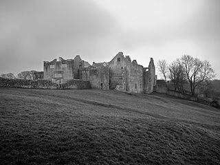
Old Beaupre Castle is a ruined medieval fortified manor house located in the community of Llanfair, outside Cowbridge in Wales. It is known in historic documents under the names Beawpire, Bewerpere, Bewpyr and Y Bewpur. It is a Grade I listed building and is under the care of Cadw. It can be visited free of charge all year round by members of the public. The gardens are designated Grade II on the Cadw/ICOMOS Register of Parks and Gardens of Special Historic Interest in Wales.

Architecture in Cardiff, the capital city of Wales, dates from Norman times to the present day. Its urban fabric is largely Victorian and later, reflecting Cardiff's rise to prosperity as a major coal port in the 19th century. No single building style is associated with Cardiff, but the city centre retains several 19th and early 20th century shopping arcades.
The Bush Inn is a Grade II listed public house in St Hilary, near Cowbridge, Vale of Glamorgan, south Wales. The current inn dates to the 16th century. It has a thatched roof, thick stone walls, low oak beams, flagstone floors, old pews, a stone spiral staircase, and an inglenook fireplace. The benches outside the pub look across to the Church of St Hilary.
A bibliography of books related to the Vale of Glamorgan, south Wales.

Llanilid is a small settlement of in the county borough of Rhondda Cynon Taf, Wales. It is in the historic county of Glamorgan. Llanilid is part of the community of Llanharan along with the villages of Bryncae, Brynna, Ynysmaerdy, Peterston-super-Montem and Llanharan itself.
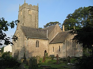
The Church of St John the Baptist is a medieval church in Llanblethian in the Vale of Glamorgan, south Wales. Believed to have been built in the 12th century, the church boasts an unusual tower, consistent with the style more common in the south west of England. It underwent extensive restoration in the late 19th century, undertaken by C. B. Fowler of Cardiff. The Church of St John was listed as a Grade I building on 22 February 1963.
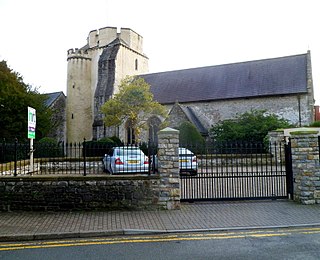
The Church of the Holy Cross is a medieval church in Cowbridge in the Vale of Glamorgan, south Wales. Initially a chapel of ease to Church of St John the Baptist, Llanblethian of Cowbridge as a medieval market town. Believed to have been built in the 13th century, the church has an unusual tower design. It has undergone several restorations including one by John Prichard in 1850–52. The Church of the Holy Cross was listed as a Grade I building on 12 May 1963.
The Vale of Glamorgan Borough Council was the local authority for the Vale of Glamorgan in South Glamorgan, Wales, created in 1974 and reconstituted in 1996 as the Vale of Glamorgan Council unitary authority. It was a second tier district authority, with South Glamorgan County Council providing county-level services to the area.
