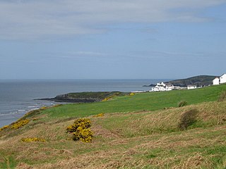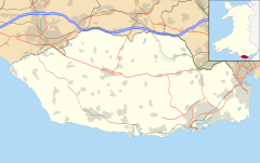
The Vale of Glamorgan, locally referred to as The Vale, is a county borough in the south-east of Wales. It borders Bridgend County Borough to the west, Cardiff to the east, Rhondda Cynon Taf to the north, and the Bristol Channel to the south. With an economy based largely on agriculture and chemicals, it is the southernmost unitary authority in Wales. Attractions include Barry Island Pleasure Park, the Barry Tourist Railway, Medieval wall paintings in St Cadoc's Church, Llancarfan, Porthkerry Park, St Donat's Castle, Cosmeston Lakes Country Park and Cosmeston Medieval Village. The largest town is Barry. Other towns include Penarth, Llantwit Major, and Cowbridge. There are many villages in the county borough.

Until 1974, Glamorgan, or sometimes Glamorganshire, was an administrative county in the south of Wales, and later classed as one of the thirteen historic counties of Wales. Originally an early medieval petty kingdom of varying boundaries known in Welsh as Morgannwg, which was then invaded and taken over by the Normans as the Lordship of Glamorgan. The area that became known as Glamorgan was both a rural, pastoral area, and a conflict point between the Norman lords and the Welsh princes. It was defined by a large concentration of castles.

The Bristol Channel is a major inlet in the island of Great Britain, separating South Wales and South West England. It extends from the smaller Severn Estuary of the River Severn to the North Atlantic Ocean. It takes its name from the English city and port of Bristol.

Penarth is a town and community in the Vale of Glamorgan, Wales, approximately 3 miles (4.8 km) south of Cardiff city centre on the west shore of the Severn Estuary at the southern end of Cardiff Bay.

Llantwit Major is a town and community in Wales on the Bristol Channel coast. It is one of four towns in the Vale of Glamorgan, with the third largest population after Barry and Penarth, and ahead of Cowbridge. It is 4+1⁄2 miles (7.2 km) from Cowbridge, 9 miles (14 km) from Bridgend, 10 miles (16 km) from Barry, and 15 miles (24 km) from Cardiff. It had a population of 9,530 in 2021.

Lavernock is a hamlet in the Vale of Glamorgan in Wales, lying on the coast 7 miles (11 km) south of Cardiff between Penarth and Sully, and overlooking the Bristol Channel.

Rhoose is a village and community near the sea in the Vale of Glamorgan, Wales, near Barry. The wider community includes villages and settlements such as Font-y-Gary, Penmark, East Aberthaw and Porthkerry. The population of the community in 2011 was 6,160.
Ogmore-by-Sea is a seaside village in St Brides Major community in the Vale of Glamorgan, Wales. It lies on the western limit of the Glamorgan Heritage Coast of south Wales. The population in 2011 was 878.

Southerndown is a village in the Vale of Glamorgan, in south Wales. It is southwest of Bridgend, and within the St Brides Major community, close to Llantwit Major and Ogmore-by-Sea. It is mostly known for its beach which backs Dunraven Bay, which is a popular tourist destination during the summer months and since 1972 has been part of a Heritage Coast and is part of the Southerndown Coast SSSI. When the tide is out there is an expanse of sand and pools. The cliffs are an obvious example of sedimentary rock.

The hamlet of Porthkerry lies on the Bristol Channel coast of South Wales within the community of Rhoose between that village and the town of Barry to the east. It is very close to the end of the runway of Cardiff International Airport. To the east of the hamlet is Porthkerry Country Park which occupies the valley leading down to the coast.

Aberthaw is an area containing the villages of East Aberthaw and West Aberthaw, on the coast of South Wales about 5 miles (8 km) west of Barry. It is home to Aberthaw Cement Works, Aberthaw Lime Works, and Aberthaw Power Station, a decommissioned coal power station that was linked to the South Wales Valleys via the Vale of Glamorgan Railway. The area is historically within the parish of Penmark in the Vale of Glamorgan. The two villages of West and East Aberthaw are separated by the River Thaw. The village of East Aberthaw, near Rhoose, has a 13th-century pub. The village Baptist Chapel and Mission Room no longer exist as such and have been converted for other uses.

Haven is a company operating a chain of holiday parks in the United Kingdom. It operates self catering static caravan holiday parks with many also including touring and camping facilities. The company operates 38 sites in the UK in predominantly coastal locations.

The geology of Wales is complex and varied; its study has been of considerable historical significance in the development of geology as a science. All geological periods from the Cryogenian to the Jurassic are represented at outcrop, whilst younger sedimentary rocks occur beneath the seas immediately off the Welsh coast. The effects of two mountain-building episodes have left their mark in the faulting and folding of much of the Palaeozoic rock sequence. Superficial deposits and landforms created during the present Quaternary period by water and ice are also plentiful and contribute to a remarkably diverse landscape of mountains, hills and coastal plains.

Gwbert, also known as Gwbert-on-Sea, is a cliff-top coastal village in Y Ferwig community, Ceredigion, Wales. It lies at the most southerly coastal point of Ceredigion, on the eastern shore of the Teifi estuary, from where there are views westwards over Cardigan Bay, and south-westwards to Poppit Sands and the headland of Cemaes Head, in neighbouring Pembrokeshire. It is reached by the B4548 road from the town of Cardigan, 2.8 miles (4.5 km) away.

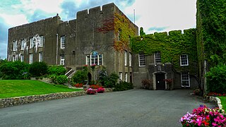
Fonmon Castle is a fortified medieval castle near the village of Fonmon in the Vale of Glamorgan and a Grade I listed building. The castle's gardens are designated Grade II on the Cadw/ICOMOS Register of Parks and Gardens of Special Historic Interest in Wales. With its origins rooted in the 12th century it is today seen as a great architectural rarity, as it is one of few buildings that was drastically remodelled in the 18th century, but not Gothicized. The castle is believed to have remained under the ownership of just two families throughout its history; from Norman times, it was owned by the St Johns, and from 1656, by the descendants of Colonel Philip Jones.

Southerndown Coast is a Site of Special Scientific Interest (SSSI) in St Brides Major community, in the Vale of Glamorgan, South Wales. It forms part of the Glamorgan Heritage Coast, bordered by the Monknash Coast to the southeast. The nearby villages are Southerndown and Ogmore-by-Sea. The SSSI extends over 5 kilometres of south-west facing coastline, with rocky limestone cliffs, broad beaches and deeply fissured wave-cut platforms.

Gwespyr is a village in Flintshire on the north coast of Wales in the community of Llanasa. Gwespyr had a population of 289 people in the United Kingdom 2001 census. It overlooks Point of Ayr on the west side of the River Dee estuary and its sandy beaches with dunes. The hills of the Clwydian Range behind the village form the eastern boundary of the Vale of Clwyd. Gwespyr also looks respectively Welsh but is an alien name. It represents Old English for 'West-bury' which came to be interpreted as the 'west fort' meaning the westernmost fort in Mercia. Originally, it is thought to have been a strategic Mercian lookout which was reduced in importance with the development of a fortified Rhuddlan.

Tresilian Bay, also Tresillian Bay, is a bay in southeast Wales, west of Llantwit Major's Collugh beach and east of St Donats, on the Bristol Channel. The beach at the bay lies in front of a valley in which the Nant Tresilian flows and empties in the sea. It lies along a stretch of coast and cliff path under protection by the Glamorgan Heritage Coast, characterised by limestone cliffs with many caves and several bays/valleys. There is a distinctive white house, Tresilian House, located at Tresilian Bay at the end of the valley in front of the pebble beach and a pill box on the cliff nearby. The cove of Col Huw is located nearby.

Fonmon is a hamlet in the Vale of Glamorgan in south Wales. It lies just off the B4265 road to the northwest of Font-y-Gary and Rhoose on the western side of Cardiff Airport. The hamlet is best known for its central duck pond and Fonmon Castle, a historical house located on the otherside of the B4265 road to the north. The largest house in the hamlet is called The Gables, accessed off a drive on the left approaching Fonmon from the north. A number of the houses in the area are thatched roofed.


