Llanblethian first came to prominence as one of the manor lordships created by the Norman lords following the Norman invasion of Wales. It was first ruled by the St. Quentins before being taken over by the Siwards. Under the Norman lordship power in the region shifted from the village to nearby Cowbridge, where manorial affairs were conducted. Llanblethian has several fine large buildings including an early 18th century great house, a 12th-century church dedicated to St John the Baptist and its own castle, a largely ruinous structure but with a fine gatehouse known locally as St Quintins Castle.
Etymology
Llanblethian takes its name from Saint Bleiddian, a contemporary of Germanus of Auxerre (Welsh: Garmon Sant). Llan is Welsh for a clearing, so the village is the 'clearing (around the church of) St Bleddian'. The root of blaidd is a translation of lupus, the wolf.[1] )
History
Evidence of early settlements in the area now known as Llanblethian have been discovered in various locations around the village. To the west of Llanblethian, between Breach and Marlborough farms, tumuli - ancient burial mounds - dating from the Bronze Age have been found.[2] On Llanblethian Hill is the site of Caer Dynnaf, a large Iron Age fort, whose walls and ditches can still be seen.[2]
The Gatehouse of St Quentin's Castle
Although no reliable accounts exist of life in Glamorgan in the first 150 years of Norman rule it is known the manor of Llanblethian existed as one of the twelve "member lordships", large areas of land that Glamorgan was divided up into by the Norman Lord Robert Fitzhamon.[3] Most of these manors, specifically the hilly valley regions were held by subservient local Welsh rulers, but Llanblethian and its neighbor Talyfan were held by Norman feudatories,[3] including Robert de Wintona, who built the Llanquian Castle. The first lord of Llanblethian manor was Robert St. Quentin, a powerful Norman knight who held lands in Wiltshire, Dorset, Essex and Yorkshire.[4] The St. Quentin family established a fortification within the village. but in 1233 the family was disposed by Richard Siward the lord of Talyfan.[5] With the lordship passing to the de Clare family, an early keep built by the St Quentin family was fortified further with the addition of a gatehouse and curtain wall.[5]
During the medieval period it is recorded that a fulling mill existed in the area, as well as wind or water powered grain mills.[2] An extensive manor stretching far beyond the village boundaries, the local economy was based heavily on agriculture.[2] It was during this period that administrative affairs of the manor began moving towards the nearby settlement of Cowbridge.[6]
By the 18th century, Llanblethian contained a few large houses, but was essentially a collection of farms with the economy supported by craftsmen with some emphasis on the weaving trade.[2] A hundred years later the village had begun attracting wealthy residents, including retired military and naval officers.[2] This still left the majority of the population made up of poorly paid labourers, servants and farm-workers.[2]
View of Llanblethian looking south from St Quintin's Castle
Up until the mid 20th century the majority of employment was local, though with changes in employment patterns in Britain the majority of residents now commute to work outside the village.[7]
Buildings of note
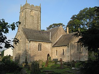
The Church of St John the Baptist is a Grade I listed building. Its earliest evidence is in the chancel which is established as 12th century, though much of the church is of a later date.[8] The west tower is in the Somerset style and is reputedly gifted by Anne Neville, the wife of King Richard III. Whether or not this is true, the tower still stands as an exotic with its features similar to those found in Cornwall and Devon, but rarely in Glamorgan.[8] The tower contains a ring of six bells which were restored and rehung in 1994.[9] The interiors are heavily restored by C. B. Fowler of Cardiff in 1896–97. Of note within the church is a stone effigy of a man with a greyhound at his feet and a simple but handsome tablet dedicated to the parents of local benefactor Sir Leoline Jenkins, dated 1763.[8][10]
The Great House on Bridge Road.
St Quintins Castle is a ruined fortification located on a spur across the valley from St John the Baptist Church.[5] Although known locally as St Quintin's Castle the only part of it which can be attributed to the St Quentin family is a mound of stones on a raised mound which has been identified as the remains of a 12th-century keep.[5] The castle begun by the St Quentins fell into the hands of Richard de Clare in 1245 after the outlawry of Richard Siward. It was de Clare's grandson Gilbert de Clare, 8th Earl of Gloucester who commenced building of the outer walls and gatehouse in 1312, but remained unfinished after his untimely death at the Battle of Bannockburn two years later.[5] The gatehouse, which still stands, is integrally built into the curtain wall.[5] The curtain wall is an irregular quadrilateral roughly 50 metres by 52 metres at its widest parts, though little remains above the foundations.[5]
On the main road through the village lies the Great House, a Grade II* listed building. A two-storey building with five bays with two-bayed recessed ends, the 18th century front is rendered and colour washed.[5] In the central gable is located a sundial bearing the initials T.W. (Thomas Wilkins) dated 1703.[5] Although this date is too early for the façade, the hall fireplace is also initialed T.W. and dated 1710.[5] There are handsome early 18th century paneling in one of the lower rooms.[5]
Footnotes
Wikimedia Commons has media related to Llanblethian.
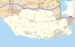
The Vale of Glamorgan, locally referred to as The Vale, is a county borough in the south-east of Wales. It borders Bridgend County Borough to the west, Cardiff to the east, Rhondda Cynon Taf to the north, and the Bristol Channel to the south. With an economy based largely on agriculture and chemicals, it is the southernmost unitary authority in Wales. Attractions include Barry Island Pleasure Park, the Barry Tourist Railway, Medieval wall paintings in St Cadoc's Church, Llancarfan, Porthkerry Park, St Donat's Castle, Cosmeston Lakes Country Park and Cosmeston Medieval Village. The largest town is Barry. Other towns include Penarth, Llantwit Major, and Cowbridge. There are many villages in the county borough.
Cowbridge is a market town in the Vale of Glamorgan, Wales, approximately 12 miles (19 km) west of the centre of Cardiff.
Ewenny Priory, in Ewenny in the Vale of Glamorgan, Wales, was a monastery of the Benedictine order, founded in the 12th century. The priory was unusual in having extensive military-style defences and in its state of preservation; the architectural historian John Newman described it as “the most complete and impressive Norman ecclesiastical building in Glamorgan”. Following the Dissolution of the Monasteries, parts of the priory were converted into a private house by Sir Edward Carne, a lawyer and diplomat. This Elizabethan house was demolished between 1803 and 1805 and replaced by a Georgian mansion, Ewenny Priory House. The house is still owned by the Turbervill family, descendants of Sir Edward. The priory is not open to the public apart from the Church of St Michael, the western part of the priory building, which continues to serve as the parish church for the village. The priory is in the care of Cadw and is a Grade I listed building.
Llantwit Major is a town and community in Wales on the Bristol Channel coast. It is one of four towns in the Vale of Glamorgan, with the third largest population after Barry and Penarth, and ahead of Cowbridge. It is 4+1⁄2 miles (7.2 km) from Cowbridge, 9 miles (14 km) from Bridgend, 10 miles (16 km) from Barry, and 15 miles (24 km) from Cardiff. It had a population of 9,530 in 2021.
Colwinston is both a village and a community in the Vale of Glamorgan, Wales, approximately 4 miles (6.4 km) southeast of the centre of Bridgend and 21 miles (34 km) west of the centre of Cardiff. The village is located within 1⁄2 mile (0.80 km) of the A48. The population in 2005 was approximately 400 but with recent building development, the population is now estimated at over 600 people.
St Athan is a village and community in the Vale of Glamorgan in South Wales. The village and its parish church are dedicated to Saint Tathan. The church dates to the 13th–14th century, though an earlier church was dated to the Norman period. The village and the adjacent dormitory village of Eglwys Brewis are known primarily for the MOD St Athan RAF base. There are two pubs in the village, as well as a football team at St Athan Football Club and the St Athan Golf Club. The community includes West Aberthaw.
Bonvilston is a village in the Vale of Glamorgan, Wales. The village is situated on the A48 about four miles east of Cowbridge and near the Welsh capital city of Cardiff. The population in 2011 was 392.
Coity Castle in Glamorgan, Wales, is a Norman castle built by Sir Payn "the Demon" de Turberville, one of the legendary Twelve Knights of Glamorgan supposed to have conquered Glamorgan under the leadership of Robert FitzHamon, Lord of Gloucester. Now in ruins, it stands in the community of Coity Higher near the town of Bridgend, in the County Borough of Bridgend. Very close to the castle is the battlemented parish Church of St Mary the Virgin, which dates from the 14th century.
St Quintins Castle is a castle located in the village of Llanblethian, Cowbridge, Wales. It is a scheduled monument and a Grade II* listed building and is under the care of Cadw. The site was first occupied with a defensive structure in about 1102 and the gatehouse and further building work took place around 1312. It was later used as a prison and was reported as being in a ruinous state by 1741.
Neath Castle is a Norman castle located in the town centre of Neath, Wales. Its construction was begun by Robert, Earl of Gloucester, the nominal Lord of Glamorgan, at a date estimated between 1114 and 1130. It is also referred to as "Granville's Castle", after Richard I de Grenville, Lord of Neath, who has also been credited with its construction. The town of Neath takes its Welsh name, "Castell-nedd", from the castle.
Pennard Castle is a ruined castle, near the modern village of Pennard on the Gower Peninsula, in south Wales. The castle was built in the early 12th century as a timber ringwork following the Norman invasion of Wales. The walls were rebuilt in stone by the Braose family at the turn of the 13th and 14th centuries, including a stone gatehouse. Soon afterwards, however, encroaching sand dunes caused the site to be abandoned and it fell into ruin. Restoration work was carried out during the course of the 20th century and the remains of the castle are now protected under UK law as a Grade II* listed building.
The Twelve Knights of Glamorgan were a "legendary" group of mercenaries who followed Robert Fitzhamon (d.1107), the Norman conqueror of Glamorgan. Although Fitzhamon was an actual historical figure, 16th-century historians, in particular Sir Edward Stradling, built upon the legend of a group of knights who ruled over the county in his stead. The fact that many of the knights existed during the period gave the legend credence.
Llandough is a village in the community of Llanfair, south of Cowbridge in the Vale of Glamorgan, Wales.
Flemingston is a small village in the Vale of Glamorgan in south Wales. It is located 8.5 miles (13.7 km) northwest by road from the town centre of Barry. It contains the Church of St. Michael the Archangel, the ruins of Flemingston Court, and Flemingston Manor or Grange, all of which are listed buildings. Historically, the parish of Flemingston was a sub-manor of Aberthaw or St Athan.
Llanilid is a small settlement of in the county borough of Rhondda Cynon Taf, Wales. It is in the historic county of Glamorgan. Llanilid is part of the community of Llanharan along with the villages of Bryncae, Brynna, Ynysmaerdy, Peterston-super-Montem and Llanharan itself.
St Mary Hill is a settlement in the Vale of Glamorgan, Wales. It is located approximately 4 miles (6.4 km) north west of the market town of Cowbridge. It is part of the community of Llangan along with Treoes and the village of Llangan itself.
Welsh St Donats is a village and a community in the Vale of Glamorgan, Wales. Consisting of 1207 hectares of mainly rural land, it is located north east of Cowbridge. The population of the community was 534 in the 2011 census. Welsh St Donats includes the villages of Maendy, Prisk and Tair Onen. A mile to the east from the village lies the Hensol Forest, while the remains of Talyfan Castle are to the north.
The Church of St John the Baptist is a medieval church in Llanblethian in the Vale of Glamorgan, south Wales. Believed to have been built in the 12th century, the church boasts an unusual tower, consistent with the style more common in the south west of England. It underwent extensive restoration in the late 19th century, undertaken by C. B. Fowler of Cardiff. The Church of St John was listed as a Grade I building on 22 February 1963.
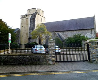
The Church of the Holy Cross is a medieval church in Cowbridge in the Vale of Glamorgan, south Wales. Initially a chapel of ease to Church of St John the Baptist, Llanblethian of Cowbridge as a medieval market town. Believed to have been built in the 13th century, the church has an unusual tower design. It has undergone several restorations including one by John Prichard in 1850–52. The Church of the Holy Cross was listed as a Grade I building on 12 May 1963.
Richard Siward was a distinguished 13th-century soldier, adventurer and banneret. He rose from obscurity to become a member of King Henry III's Royal Council and husband of Philippa Basset, the widowed countess of Warwick.
This page is based on this Wikipedia article Text is available under the CC BY-SA 4.0 license; additional terms may apply. Images, videos and audio are available under their respective licenses.