The Herberts

Last updated

The Herberts
New Housing at The Herberts (geograph 4403054).jpg
The Herberts (2015)
Vale of Glamorgan UK location map.svg
Red pog.svg
The Herberts
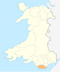
Location within the Vale of Glamorgan
Principal area
Preserved county
Country Wales
Sovereign state United Kingdom
Postcode district CF
Police South Wales
Fire South Wales
Ambulance Welsh
UK Parliament
Senedd Cymru – Welsh Parliament
List of places
UK
Wales
Vale of Glamorgan
51°26′17″N3°26′25″W / 51.438136°N 3.44038°W / 51.438136; -3.44038

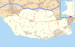
The Herberts is a hamlet in the Vale of Glamorgan, Wales. It is located immediately to the north of the village of St. Mary Church and southwest of Llandough, 2.2 miles by road southwest of the market town centre of Cowbridge along St Athan Road. [1] The River Thaw flows through The Herberts.
Landmarks

The fortified manor house, Old Beaupre Castle, is located to the northeast. Parwg Well and the Howe Mill also lie just to the northeast

The old garage in the main street was used as a location for the television series, Cowbois ac Injans .

Roadside ditch at the Herberts Roadside ditch at The Herberts - Cowbridge - geograph.org.uk - 1262060.jpg
Roadside ditch at the Herberts

Related Research Articles

<span class="mw-page-title-main">Interstate 44</span> Interstate Highway mostly in Oklahoma and Missouri

Interstate 44 (I-44) is a major Interstate Highway in the central United States. Although it is nominally an east–west road as it is even-numbered, it follows a more southwest–northeast alignment. Its western terminus is in Wichita Falls, Texas, at a concurrency with U.S. Route 277 (US 277), US 281, and US 287; its eastern terminus is at I-70 in St. Louis, Missouri. I-44 is one of five Interstates built to bypass US 66; this highway covers the section between Oklahoma City and St. Louis. Virtually the entire length of I-44 east of Springfield, Missouri, was once US 66, which was upgraded from two to four lanes from 1949 to 1955. The section of I-44 west of Springfield was built farther south than US 66 in order to connect Missouri's section with the already completed Will Rogers Turnpike, which Oklahoma wished to carry their part of I-44.

<span class="mw-page-title-main">Horsham, Pennsylvania</span> Census-designated place in Pennsylvania, United States

Horsham is a home rule municipality in Montgomery County, Pennsylvania, United States. The population was 15,193 at the 2020 census. Horsham is located entirely within Horsham Township, and it is home to the Horsham Air Guard Station at the former site of Naval Air Station Joint Reserve Base Willow Grove.

<span class="mw-page-title-main">Indiana State Road 37</span> Highway in Indiana

State Road 37 (SR 37) is a major route in the U.S. state of Indiana, running as a four-lane divided highway for 110 miles of its course.

<span class="mw-page-title-main">South Carolina Highway 6</span> State highway in South Carolina

South Carolina Highway 6 (SC 6) is a 116.092-mile (186.832 km) primary state highway in the U.S. state of South Carolina. It extends from US 76 in Ballentine to US 52/SC 6 Truck in Moncks Corner. It uniquely links all three of the major hydropower projects in South Carolina: Lake Murray, Lake Marion, and Lake Moultrie.

<span class="mw-page-title-main">Aubigny-aux-Kaisnes</span> Commune in Hauts-de-France, France

Aubigny-aux-Kaisnes is a commune in the department of Aisne in the Hauts-de-France region of northern France.

<span class="mw-page-title-main">Artemps</span> Commune in Hauts-de-France, France

Artemps is a commune in the department of Aisne in the Hauts-de-France region of northern France.

<span class="mw-page-title-main">Barenton-Cel</span> Commune in Hauts-de-France, France

Barenton-Cel is a commune in the department of Aisne in the Hauts-de-France region of northern France.

<span class="mw-page-title-main">Barenton-sur-Serre</span> Commune in Hauts-de-France, France

Barenton-sur-Serre is a commune in the department of Aisne in the Hauts-de-France region of northern France.

<span class="mw-page-title-main">U.S. Route 67 in Arkansas</span> Section of U.S. Highway in Arkansas, United States

U.S. Route 67 is a U.S. highway running from Presidio, Texas northeast to Sabula, Iowa. In the U.S. state of Arkansas, the route runs 279.15 miles (449.25 km) from the Texas border in Texarkana northeast to the Missouri border near Corning. The route passes through several cities and towns, including Hope, Benton, Little Rock, Jacksonville, Cabot, Beebe, Walnut Ridge, and Pocahontas.

Nagalama, whose correct phonetic spelling is Naggalama is a town in Uganda's Central Region.

The Moccasin Mountains is an 11-mile-long (18 km) mountain range located at the Arizona–Utah border in Mohave County, Arizona, and a small north section in Kane County, Utah.

Abayita Ababiri, sometimes spelled Abaita Ababiri, is a neighborhood in Uganda.

Phillipsburg is an unincorporated community in south Washington County, in the U.S. state of Texas. The very small rural community is located along State Highway 36 (SH 36) south of Brenham. Aside from the names of two local roads, the name Phillipsburg is no longer marked on modern maps. The cemetery and Lutheran church, which is still open for worship, are actually slightly to the south in neighboring Austin County.

References

  1. Maps (Map). Google Maps.