
Pentrebane is a district in the west of Cardiff, capital of Wales. It is part of the Fairwater community.

The Taff Trail is a walking and cycle path that runs for 55 miles (89 km) between Cardiff Bay and Brecon in Wales. It is so named because it follows the course of the River Taff. Along much of its length, it follows the National Cycle Network Route 8 that continues to Holyhead, and is substantially off-road.
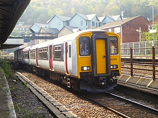
The Merthyr line is a commuter railway line in South Wales; it connects Cardiff Central with Merthyr Tydfil and Aberdare. The line is part of the Cardiff urban rail network, known as the Valley Lines.
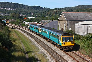
The Rhondda line, also known as the Treherbert line, is a commuter railway line in South Wales from Cardiff to Treherbert. The line follows the Merthyr line as far as Pontypridd, where it then diverges to continue along the Rhondda Valley.

Bassaleg is a village on the west side of Newport, Wales. It is in the Graig electoral ward and community.

The A4232, which is also known either as the Peripheral Distributor Road (PDR) (Welsh: Ffordd Ddosbarthu Ymylol) or the Cardiff Link Road (Welsh: Ffordd Gyswllt Caerdydd), is a distributor road in Cardiff, the capital of Wales.

Bute Street is a street in Cardiff, Wales. It links Cardiff Bay and Butetown with Cardiff city centre. It now has no road number. It runs from the dockside of the Mermaid Quay complex in the south, which is now a pedestrian zone, to the junction of Bute Terrace (A4160) in the north.

The Cathays electoral ward of Cardiff, created in 1890, which since 1974 has covered the Cathays and Castle communities. There is no community council for the area and it has elected four councillors since 1999.

Brithdir is a small village in the northern part of the Rhymney Valley near New Tredegar, in the county borough of Caerphilly, south Wales.

The Pierhead Building is a Grade I listed building in Cardiff Bay, Wales. It was built in 1897 as the headquarters for the Bute Dock Company.

The A4050 road connects Barry, Vale of Glamorgan with Culverhouse Cross on the outskirts of Cardiff, Wales. It is approximately 10 miles (16 km) long, and is the key link road between the M4 motorway and Cardiff International Airport.

The Wales International Academy of Voice was established by its founder, the Welsh tenor Dennis O'Neill CBE, to provide advanced voice, music and drama coaching to young professional opera singers from all over the world in the early stages of their careers. It was opened in 2007 as the Cardiff International Academy of Voice and was funded by Cardiff University. Following Cardiff University's withdrawal of funding in 2010, the University of Wales Trinity Saint David took over the partnership in June 2011 under the new name of the Wales International Academy of Voice.
Lloyd George Avenue, originally known as Bute Avenue, is an avenue in Cardiff, Wales. Roughly one mile long, the road links the Inner Harbour of Cardiff Bay to Cardiff city centre and forms part of the A470 road. It runs parallel to Bute Street and the Butetown Branch Line. Landscaping on the route was completed in 2000, and it was renamed after the Liberal prime minister David Lloyd George. The site of the avenue had been known as Collingdon Road, which was described as a "grimy industrial area of small factories and workshops, employing hundreds of people".

Caerleon railway station is a former station serving Caerleon on the east side of the city of Newport, UK and a proposed future station as part of the South Wales Metro.
Newport West Central railway station is a proposed station on the Ebbw Valley Railway in the city of Newport, Wales.

Wildmill or Wild Mill is a district in the town of Bridgend, south Wales.

Coleg y Cymoedd is a further education college located at four main campuses across Rhondda Cynon Taf, and Caerphilly, Wales. Coleg y Cymoedd was formed after the merger of Coleg Morgannwg and Ystrad Mynach College in September 2013.

Cardiff Parkway is a planned railway station in the eastern region of Cardiff, and near to the boundary with the neighbouring city of Newport. The station is privately funded as part of the wider Cardiff Hendre Lakes business development.
Gabalfa is a proposed railway station on the Merthyr line in the Gabalfa district of Cardiff, Wales. The station would be on the South Wales Metro and be part of the Wales & Borders franchise. It is planned to open in 2028. It will be located on an old coal yard next to the existing railway. This followed significant local petitioning for a railway station from Gabalfa and Mynachdy. A station in the Gabalfa ward was first proposed by Cardiff County Council in 2000.
Heath is the name of an electoral ward in the north of the city of Cardiff, Wales, which covers its namesake community, Heath. The ward elects three county councillors to the County Council of the City and County of Cardiff.
