Great Brynhill

Last updated

Great Brynhill
Great Brynhill Farm.jpg
Great Brynhill Farmhouse
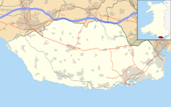
Vale of Glamorgan UK location map.svg
Red pog.svg
Great Brynhill
Location within the Vale of Glamorgan
Principal area
Ceremonial county
Country Wales
Sovereign state United Kingdom
Postcode district CF
Police South Wales
Fire South Wales
Ambulance Welsh
UK Parliament
Senedd Cymru – Welsh Parliament
List of places
UK
Wales
Vale of Glamorgan
51°25′39″N3°16′56″W / 51.4275°N 3.282222°W / 51.4275; -3.282222 Coordinates: 51°25′39″N3°16′56″W / 51.4275°N 3.282222°W / 51.4275; -3.282222

Great Brynhill is a small hamlet and farm in the Vale of Glamorgan in south Wales. It consists little more than a few farms including the Little Brynhill Farm and Thorn Falcon Farm (Little Brynhill) and the Great Brynhill Farm. It is located in the historical parish of Merthyr Dyfan and near Colcot [1] now northern districts of the town of Barry. [2] It is accessed via a lane from Port Road (the A4050 road) but can also be accessed from Dyffryn along the lane to the New Wallace Farm and Goldsland which lie just to the northeast. [3]

Great Brynhill Lane, the larger farm in the distance at the foot of the "Brynhill" Track to Great Brynhill Farm.jpg
Great Brynhill Lane, the larger farm in the distance at the foot of the "Brynhill"

"Bryn" means "hill" in Welsh, so the name literally means "Great hill hill". [4] The Little Brynhill Farm is owned by the Tanner family who are notable milk suppliers in Barry under the company name "W. A. Tanner & Son". [5] One of the farms sold off some of their land along with neighbouring Highlight Farm when Brynhill Golf Club was formed in 1921. According to the Barry & District News , Thorn Falcon Farm sold for £400,000 on 25 November 2005. [6]
Related Research Articles

Vale of Glamorgan County borough

The Vale of Glamorgan, often referred to as The Vale, is a county borough in Wales, bordering Bridgend, Cardiff, and Rhondda Cynon Taf. With an economy based largely on agriculture and chemicals, it is the southernmost unitary authority in Wales. Attractions include Barry Island Pleasure Park, the Barry Tourist Railway, Medieval wall paintings in St Cadoc's Church, Llancarfan, Porthkerry Park, St Donat's Castle, Cosmeston Lakes Country Park and Cosmeston Medieval Village.

Llantwit Major Human settlement in Wales

Llantwit Major is a town and community in Wales. Situated on the Bristol Channel coast, it is one of four towns in the Vale of Glamorgan, with the third largest population after Barry and Penarth, and ahead of Cowbridge. Llantwit Major is 4+12 miles (7.2 km) from Cowbridge, 9 miles (14 km) from Bridgend, 10 miles (16 km) from Barry, and 15 miles (24 km) from Cardiff. The community had a population of 9,486 in 2011.

Colwinston Human settlement in Wales

Colwinston is both a village and a community in the Vale of Glamorgan, Wales, approximately 4 miles (6.4 km) southeast of the centre of Bridgend and 21 miles (34 km) west of the centre of Cardiff. The village is located within 12 mile (0.80 km) of the A48. The population in 2005 was approximately 400 but with recent building development, the population is now estimated at over 600 people.

Sully, Vale of Glamorgan Human settlement in Wales

Sully is a village in the community of Sully and Lavernock, in the Vale of Glamorgan, Wales lying on the northern coast of the Bristol Channel, midway between the towns of Penarth and Barry and 7 miles southwest of the Welsh capital city of Cardiff.

Dinas Powys Human settlement in Wales

Dinas Powys is a large village and a community in the Vale of Glamorgan in South Wales which takes its name from the ancient Welsh for stronghold (Dinas), and pagus (Powys), the Latin word for an outlying or rural settlement. The literal meaning, therefore, being, "Settlement Stronghold", referring to Dinas Powys hillfort, which dates from the Iron Age. The village is 5.6 miles (9.0 km) south-west of the centre of Cardiff and conveniently situated on the A4055 Cardiff to Barry main road, almost merging with Penarth. It is generally regarded as a pleasant dormitory village for Cardiff's commerce and industry commuters since the city has expanded with widespread development around the Cardiff Bay area.

Corntown Human settlement in Wales

Corntown is a small village in the Vale of Glamorgan. It lies along the B4524 road, just outside Bridgend, 21.6 miles west of the centre of Cardiff. It has grown around Corntown Farm. Chapel Wood frames part of its western side. The Golden Mile Inn lies along the B4524 just to the northeast of the village.

Porthkerry Human settlement in Wales

The hamlet of Porthkerry lies on the Bristol Channel coast of South Wales within the community of Rhoose between that village and the town of Barry to the east. It is very close to the end of the runway of Cardiff International Airport. To the east of the hamlet is Porthkerry Country Park which occupies the valley leading down to the coast.

Gileston Human settlement in Wales

Gileston is a small Welsh village near West Aberthaw in Bro Morgannwg on the coast of South Wales.

Colcot District of Barry in Wales

Colcot is a northern district of Barry, Vale of Glamorgan, in the Dyfan ward of South Wales. Dyfan ward is situated in the north west of Barry and its most northern edge is on the green belt of the town. Port Road West runs through the ward and is the main route to Cardiff and Cardiff International Airport in Rhoose. Dyfan benefits from a sports centre and Buttrills recreation field and The Barry Hospital can be found on Colcot Road. It also contains the Colcot Primary School, the Colcot Arms pub, the St David's Methodist Church, Coastlands Family Church, a fish and chip shop/Chinese takeaway, Barry Arts Centre and Merthyr Dyfan Cemetery.

Barry Council Office and Library

Barry Council Office and Library is a local government building and public library located in King Square, Barry, Wales. The building, which was once the meeting place of Barry Municipal Borough Council, is a Grade II listed building.

Buttrills District of Barry and ward in Wales

Buttrills is a northwestern-central district of Barry in the Vale of Glamorgan, in south Wales. It is also an electoral ward of the Vale of Glamorgan, the population of which taken at the 2011 census was 6,357. The centre of education in Barry in the early twentieth century, Buttrills today contains notable playing fields and Barry Cemetery.

Merthyr Dyfan District of Barry and parish/ward in Wales

Merthyr Dyfan or Dyfan is a northeastern suburb of Barry in the Vale of Glamorgan, in south Wales, formerly an independent medieval village. It is also an ecclesiastical parish and a formal electoral ward of the Vale of Glamorgan. It borders Colcot to the west, Buttrills to the southwest and Gibbonsdown to the southeast. Its main roads are Merthyr Dyfan Road, a hilly road leading down from the A4050 road which leads into Wenvoe and Cardiff; and Skomer Road which separates it from Gibbonsdown and eventually also leads to the A4050 road. Merthyr Dyfan contains an old parish church, Barry Rugby Club, Bryn Hafren Comprehensive School and the Master Mariner Pub and Holm View Leisure Centre, although the last two could be considered to be in northern Gibbonsdown.

Clemenstone Human settlement in Wales

Clemenstone or Clemenston is a hamlet located in the western part of the Vale of Glamorgan, southeast Wales, southeast of Bridgend. Historically part of Glamorgan, it contains the Clemenstone Estate and House, long-time seat of the Curre family, and a Sports Academy. Clemenstone Meadows are a Site of Special Scientific Interest (SSSI).

Castellau Human settlement in Wales

Castellau is a hamlet, with a country house of the same name in the county borough of Rhondda Cynon Taf, South Wales. Historically, it lies within the parish of Llantrisant, just north-west of Beddau. It is connected with the history of the Trahernes. In 1988, Ysgol Castellau became the first Welsh medium education school to open in the southeast within new buildings.

Wenvoe Castle

Wenvoe Castle was a castle and country estate between Barry and Wenvoe, in the Vale of Glamorgan, south Wales. Today the former estate forms the Wenvoe Castle Golf Club. Goldsland lies on its western boundary.

Lidmore Human settlement in Wales

Lidmore or Lydmore is a small hamlet and farm in the Vale of Glamorgan. It is located just off the A4226 road, to the northwest of Highlight Park in Barry, Vale of Glamorgan and in close proximity to Brynhill Golf Club. To the north is Great Hamston and Dyffryn and the hamlet is accessed through another hamlet called Northcliff from the main road. To the southwest is Lidmore Wood and the Welsh Hawking Centre.

Dyffryn, Vale of Glamorgan Human settlement in Wales

Dyffryn, often Duffryn, is a small village in the Vale of Glamorgan in south Wales. It is located 4.8 miles (7.7 km) north of the town centre of Barry, roughly 1 mile (1.6 km) west of St Lythans and 2 miles (3.2 km) south of St. Nicholas. It lies off the A4226 road, along St Lythans Road, directly east of Walterston. Dyffryn is best known for its Dyffryn Gardens and its megalithic monuments nearby including the Tinkinswood and St Lythans Burial Chamber and also the caves of nearby Goldsland. The River Waycock flows through the village.

Great Hamston Human settlement in Wales

Great Hamston is a small hamlet and farm in the Vale of Glamorgan in south Wales. It is located about 4.2 miles (6.8 km) north of the town centre of Barry, about 600 metres to the south of the main village of Dyffryn, even nearer to Lower Dyffryn, west along the lane from Goldsland, and just north of Lidmore and North Cliff Farm. It lies off the A4226 road. The River Waycock flows through the hamlet and the Goldsland Brook joins this stream from the east just to the northeast of Great Hamston. The Hamston Pond Cottage is let out to tourists. Just to the north is the Aqua farm, Dyffryn Springs, which is a noted commercial fishing spot for trout in the county and the hamlet also contains an allotment. Great Hamston Farm has a distinctive white tower which can be viewed on Bing Maps Birdseye view. The lane to Goldsland and Wenvoe to the east contains the Old Wallace Farm and the New Wallace Farm.

Flemingston Human settlement in Wales

Flemingston is a small village in the Vale of Glamorgan in south Wales. It is located 8.5 miles (13.7 km) northwest by road from the town centre of Barry. It contains the Church of St. Michael the Archangel, the ruins of Flemingston Court, and Flemingston Manor or Grange, all of which are listed buildings. Historically, the parish of Flemingston was a sub-manor of Aberthaw or St Athan.

St Mary Hill Human settlement in Wales

St Mary Hill is a settlement in the Vale of Glamorgan, Wales. It is located approximately 4 miles (6.4 km) north west of the market town of Cowbridge. It is part of the community of Llangan along with Treoes and the village of Llangan itself.

References

  1. Owen, D. Huw (1989). Settlement and Society in Wales. University of Wales Press. ISBN   978-0-7083-0985-8.
  2. Williams, Stewart; Denning, R. T. W. (1971). Stewart Williams' Glamorgan historian. D. Brown. p. 151.
  3. Maps (Map). Google Maps.
  4. Baugh, Albert Croll; Cable, Thomas (1993). A History of the English Language. Routledge. p. 73. ISBN   978-0-415-09379-8.
  5. "W A TANNER & SON". Cylex. Retrieved 19 April 2012.
  6. "Thorn Falcon Farm Great Brynhill Lane". Barry & District News . Retrieved 19 April 2012.