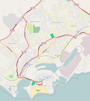
The Vale of Glamorgan, locally referred to as The Vale, is a county borough in the south-east of Wales. It borders Bridgend County Borough to the west, Cardiff to the east, Rhondda Cynon Taf to the north, and the Bristol Channel to the south. With an economy based largely on agriculture and chemicals, it is the southernmost unitary authority in Wales. Attractions include Barry Island Pleasure Park, the Barry Tourist Railway, Medieval wall paintings in St Cadoc's Church, Llancarfan, Porthkerry Park, St Donat's Castle, Cosmeston Lakes Country Park and Cosmeston Medieval Village. The largest town is Barry. Other towns include Penarth, Llantwit Major, and Cowbridge. There are many villages in the county borough.

Until 1974, Glamorgan, or sometimes Glamorganshire, was an administrative county in the south of Wales, and later classed as one of the thirteen historic counties of Wales. Originally an early medieval petty kingdom of varying boundaries known in Welsh as Morgannwg, which was then invaded and taken over by the Normans as the Lordship of Glamorgan. The area that became known as Glamorgan was both a rural, pastoral area, and a conflict point between the Norman lords and the Welsh princes. It was defined by a large concentration of castles.

Llantwit Major is a town and community in Wales on the Bristol Channel coast. It is one of four towns in the Vale of Glamorgan, with the third largest population after Barry and Penarth, and ahead of Cowbridge. It is 4+1⁄2 miles (7.2 km) from Cowbridge, 9 miles (14 km) from Bridgend, 10 miles (16 km) from Barry, and 15 miles (24 km) from Cardiff. It had a population of 9,530 in 2021.

South Wales is a loosely defined region of Wales bordered by England to the east and mid Wales to the north. Generally considered to include the historic counties of Glamorgan and Monmouthshire, south Wales extends westwards to include Carmarthenshire and Pembrokeshire. In the western extent, from Swansea westwards, local people would probably recognise that they lived in both south Wales and west Wales. The Brecon Beacons National Park covers about a third of south Wales, containing Pen y Fan, the highest British mountain south of Cadair Idris in Snowdonia.
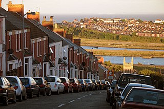
Barry is a town and community in the Vale of Glamorgan, Wales. It is on the north coast of the Bristol Channel approximately 9 miles (14 km) south-southwest of Cardiff. Barry is a seaside resort, with attractions including several beaches and the resurrected Barry Island Pleasure Park. According to Office for National Statistics 2021 estimate data, the population of Barry was 56,605.
Dinas Powys is a small town and community in the Vale of Glamorgan, South Wales. Its name means "fort of the provincial place" and refers to the Iron Age hillfort which overlooks the village. Dinas Powys is 5.6 miles (9.0 km) south-west of the centre of Cardiff and is situated on the A4055 road from Cardiff to Barry, making it a popular dormitory village for city commuters. It neighbours the larger town of Penarth.

The hamlet of Porthkerry lies on the Bristol Channel coast of South Wales within the community of Rhoose between that village and the town of Barry to the east. It is very close to the end of the runway of Cardiff International Airport. To the east of the hamlet is Porthkerry Country Park which occupies the valley leading down to the coast.

Palmerstown is a south-eastern suburb of Barry in the Vale of Glamorgan south-west of Dinas Powys and 7 miles south-west of Cardiff in Wales. It is immediately north of chemical and plastics industries such as Dow Chemicals, and Barry No.2 dock and the Atlantic Trading Estate lie south-east of No.2 dock. Its south end is separated from the A4055 Cardiff-Barry main road via Palmerston Road, (sic) a tee junction with the A4055 and access to the original part of Palmerstown's housing is via a narrow railway bridge over the Barry-Cardiff railway line and lies north-west of the former Biglis Junction which was a short distance from the so-called "Palmerston Bridge" which separates Palmerston Road from Dobbins Road.

Gibbonsdown, colloquially known as 'Gibby', is a residential area and electoral ward situated in the north east of Barry in the Vale of Glamorgan, Wales. Gibbonsdown borders Merthyr Dyfan to the northwest and Cadoxton to the southeast.
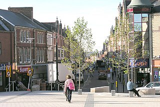
Holton is a central district of Barry in the Vale of Glamorgan 9 miles outside Cardiff in south Wales. As the Central business district of Barry it is dominated by Barry shopping centre and Barry Town Library. It also has Holton Road School which is the biggest primary school in the vale and it was built in 1895.
Cadoxton, is a village situated in Neath Port Talbot county borough, Wales. Cadoxton is located just outside the town of Neath and borders the villages of Cilfrew and Bryncoch. The village has 1,684 residents and is located in the Cadoxton ward. Cadoxton elected a Liberal Democrat representative in the 2008 council elections.

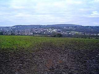
Church Village is a large village in the historic parish and community of Llantwit Fardre, located within the Taff Ely district of the County Borough of Rhondda Cynon Taf in Wales. The village is centrally located being around 4 miles (6.4 km) from the local principal towns of Llantrisant to the southwest and Pontypridd to the north and is situated around 10 miles (16 km) northwest of Cardiff city centre.

The Afon Clun is a 14-mile (23 km) long tributary of the River Ely, in the counties of Cardiff and Rhondda Cynon Taf, Wales. Its bedrock is predominantly of sandstone. Beginning on the western slope of The Garth the river is fast-flowing, in clear shallow water with a hard substrate, flowing to the south of Llantrisant and generally west to its confluence with the River Ely at Pontyclun, falling 715 feet (218 m) over its course.

Buttrills is a northwestern-central district of Barry in the Vale of Glamorgan, in south Wales. It is also an electoral ward of the Vale of Glamorgan, the population of which taken at the 2011 census was 6,357. The centre of education in Barry in the early twentieth century, Buttrills today contains notable playing fields and Barry Cemetery.

Ogmore Valley is a community in the Bridgend County Borough, Mid Glamorgan, Wales. Made up of the villages of Nantymoel, Ogmore Vale, Price Town and Wyndham, its population at the time of the 2001 census was 7,800, increasing to 7,954 at the 2011 Census. The ribbon housing of the valley follows the Ogwr Fawr tributary which rises at Craig Ogwr and joins the Ogwr Fach at Blackmill. Villages include Nantymoel, Price Town, Wyndham, Ogmore Vale, Lewistown, Pant-yr-awel and Blackmill.

The Memo Arts Centre, formerly known as Barry Memorial Hall or Memorial Hall & Theatre, popularly known as The Memo, is a prominent venue in Barry, Vale of Glamorgan, currently the "largest multi-arts venue in the Vale of Glamorgan, and only cinema exhibitor in Barry". It is situated in the Gladstone neighbourhood on Gladstone Road, off Holton Road. It was inaugurated in November 1932, and obtained its name in remembrance of those locals who died in World War I.

Court is the name of an electoral ward in Barry, Vale of Glamorgan, Wales. It is represented by councillors on Barry Town Council and the Vale of Glamorgan Council.

Cowbridge is the name of an electoral ward in the Vale of Glamorgan, Wales, which covers its namesake town of Cowbridge as well as the neighbouring villages of Llanblethian and Aberthin and the communities of Llanfair and Penllyn. The ward elects three county councillors to the Vale of Glamorgan Council.

Rhoose is the name of an electoral ward in the Vale of Glamorgan, Wales, which covers its namesake village, Rhoose, as well as Penmark and the neighbouring community of Llancarfan. The ward elects three county councillors to the Vale of Glamorgan Council.
The Vale of Glamorgan Association Football League is a football league covering the area of the Vale of Glamorgan in Glamorgan, South Wales and the surrounding areas. The leagues are at the seventh and eighth levels of the Welsh football league system.