Colcot

Last updated
Colcot
District of Barry
Children's Play Area, Port Road, Barry - geograph.org.uk - 286099.jpg
Colcot Primary School
Location map Wales Vale of Glamorgan Barry.png
Red pog.svg
Colcot
Location in Barry
Coordinates: 51°25′08″N3°16′47″W / 51.41889°N 3.27972°W / 51.41889; -3.27972
Country United Kingdom
Region Wales
County Vale of Glamorgan
Town Barry
Time zone UTC+0 (GMT)

Colcot is a northern district of Barry, Vale of Glamorgan, in the Dyfan ward of South Wales. Dyfan ward is situated in the north west of Barry and its most northern edge is on the green belt of the town. Port Road West runs through the ward and is the main route to Cardiff and Cardiff International Airport in Rhoose. Dyfan benefits from a sports centre and Buttrills recreation field and The Barry Hospital is located on Colcot Road. [1] It also contains the Colcot Primary School, the Colcot Arms pub, the St David's Methodist Church, Coastlands Family Church, a fish and chip shop/Chinese takeaway, Barry Arts Centre and Merthyr Dyfan Cemetery.

Contents

History

Nearby Merthyr Dyfan contained land belonging to a sub manor of Cadoxton. It contained two carucates and 240 customary acres of arable land, and there was a court or grange belonging to it in Colcot. [2] Historically the farms Colcot Fawr and Colcot Ganol were in the vicinity, and a Collcot Farm is also mentioned in 1784. [3] Colcot Fawr, once belonging to a John Love, was situated on the west side of Colcot Road, [4] likely near where the Barry Comprehensive School now is. A prosperous farmer, he made his will in 1667 and died shortly afterwards in 1668; he is buried at Merthyr Dyfan church. [5] The property was taken over by Thomas Love, who held Colcot Fawr until his death in 1683 when he is documented to have given £20 to his sisters Anne Love and Margaret Richard, and to his nephews and nieces, and a handsome number of his possessions to his brother Arnold. [6] Anne is documented to have died in 1690, worth £41 and owed £29, 3 shillings. [7]

Colcot Primary School was built in 1952. [8] Many of the council houses in the area were built in the 1950s; a testament to the period they were built today is street names like Elizabeth Avenue, named after the then recently crowned Queen and Margaret Avenue, named after her sister Princess Margaret. Barry Hospital, on Colcot Road, was established in the mid 1990s. [9]

Crime

According to the Neighbourhood crime league table [10] Dyfan ward has the lowest crime rate in Barry. The league table looks at the total crimes and crime rate for September 2014 that occurred in all neighbourhoods within 5 miles of Dyfan and orders them by lowest crime rate first.

Most notable crimes are the following; On 20 April 2006, an 18-year-old was left with a "cut eye, head injuries and a broken nose" after being punched and robbed of just a few pence by thugs at a bus stop near Colcot Cemetery. [11] In April 2007, during the Easter holidays, vandals smashed 17 windows of Colcot Primary School, "trashed classrooms, chopped down trees and littered the playground with dozens of cans and broken beer bottles", prompting then headmaster Ieuan Richards to state, "The scale of the vandalism is just horrifying". [12] A fire broke out at a house in Shelley Crescent in December 2007. [13] Four years later on the same street, it was reported that a man had his nose broken in a fight. [14] Colcot Community Centre on Keats Way allows residents affected by local crime to liaise with police officers. [15]

Landmarks

The Colcot Arms pub Colcot Arms, Barry - geograph.org.uk - 3286004.jpg
The Colcot Arms pub

The Colcot Arms pub is on Colcot Road, [16] not far from the A4050 road. Scenes from the popular series Gavin & Stacey were shot in the pub. [17] Along Winston Road, which passes from Colcot Road (near the pub) to Merthyr Dyfan Road, contains a number of shops. At the Colcot Road end there is the St David's Methodist Church, a Spar market, a fish and chip shop/Chinese takeaway, a hair salon, and Barry Arts Centre, and further down the road is Winston Square. It once contained several small shops, but these were later closed and boarded up, causing problems in the area with vandalism. From the 1990s there was a movement to redevelop the square with new shops which were due to open in November 1999, but in 2002 it was announced that local pressure was still mounting to build new shops to breathe new life into the community. [18] After six years of "legal wrangling and negotiations over leases and other matters" and numerous acts of vandalism, in October 2005 the dilapidated flats on the square were finally demolished and a new £250,000 development with a general store, chemist shop, and a take-away was built. [19]

Sports facilities include the Colcot Sports Centre and playing fields, and Colcot Sports Hall. Activities in these facilities include: weight training, football, basketball, badminton, hockey, rugby union, cricket, and rock climbing with a climbing wall. Colcot Sports Centre hosts an annual "mini-hockey festival", featuring mixed under-11 teams from Barry Island, Romilly, Palmerston, St Helen's of Barry, Llancarfan, Pendoylan, and Westbourne (Penarth). [20]

Near the Colcot Road/A4050 (Port Road) roundabout is the entrance to Brynhill Golf Club, to the west of the hamlet of Great Brynhill. The 18-hole, 5947 yard golf course was established in 1921. [21]

Notable people

Related Research Articles

<span class="mw-page-title-main">Merthyr Tydfil</span> Town in Wales

Merthyr Tydfil is the main town in Merthyr Tydfil County Borough, Wales, administered by Merthyr Tydfil County Borough Council. It is about 23 miles (37 km) north of Cardiff. Often called just Merthyr, it is said to be named after Tydfil, daughter of King Brychan of Brycheiniog, who according to legend was slain at Merthyr by pagans about 480 CE. Merthyr generally means "martyr" in modern Welsh, but here closer to the Latin martyrium: a place of worship built over a martyr's relics. Similar place names in south Wales are Merthyr Cynog, Merthyr Dyfan and Merthyr Mawr.

<span class="mw-page-title-main">Taff Trail</span> Walking and cycling track in South Wales

The Taff Trail is a popular walking and cycle path that runs for 55 miles (89 km) between Cardiff Bay and Brecon in Wales. It is so named because it follows the course of the River Taff. Along much of its length, it follows the National Cycle Network Route 8 that continues to Holyhead, and is substantially off-road.
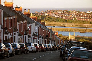
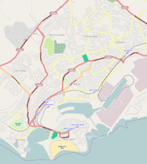
<span class="mw-page-title-main">Barry, Vale of Glamorgan</span> Town in the Vale of Glamorgan, Wales

Barry is a town in the Vale of Glamorgan, Wales, on the north coast of the Bristol Channel approximately 9 miles (14 km) south-southwest of Cardiff. Barry is a seaside resort, with attractions including several beaches and the resurrected Barry Island Pleasure Park. According to Office for National Statistics 2016 estimate data, the population of Barry was 54,673.

<span class="mw-page-title-main">Abercynon</span> Human settlement in Wales

Abercynon, is both a village and a community in the Cynon Valley within the unitary authority of Rhondda Cynon Taf, Wales. The community comprises the village and the districts of Carnetown and Grovers Field to the south, Navigation Park to the east, and Glancynon to the north.

<span class="mw-page-title-main">Cwmdare</span> Human settlement in Wales

Cwmdare is a village very close to Aberdare, in Rhondda Cynon Taf, Wales. The village's history is intertwined with coal-mining, and since the decline of the industry in the 1980s, it has become primarily a commuter base for the larger surrounding towns of Aberdare and Merthyr Tydfil and Pontypridd, as well as the cities of Cardiff and Swansea.

<span class="mw-page-title-main">Gibbonsdown</span> District of Barry in Wales

Gibbonsdown, colloquially known as 'Gibby', is a residential area and electoral ward situated in the north east of Barry in the Vale of Glamorgan, Wales. Gibbonsdown borders Merthyr Dyfan to the northwest and Cadoxton to the southeast.

<span class="mw-page-title-main">District of Rhymney Valley</span> Former district of Mid Glamorgan, Wales

Rhymney Valley was one of six local government districts in Mid Glamorgan from 1974 to 1996.

The suburban district of Sketty is about 2 miles (3.2 km) west of the Swansea city centre on Gower Road. It falls within the Sketty council ward of Swansea. It is also a community.

<span class="mw-page-title-main">A4050 road</span> Road in Vale of Glamorgan

The A4050 road connects Barry, Vale of Glamorgan with Culverhouse Cross on the outskirts of Cardiff, Wales. It is approximately 10 miles (16 km) long, and is the key link road between the M4 motorway and Cardiff International Airport.

<span class="mw-page-title-main">A4226 road</span> Road in the Vale of Glamorgan

The A4226 is a main road linking Bonvilston to Barry and Cardiff International Airport (CIA) in the Vale of Glamorgan, Wales.

<span class="mw-page-title-main">Gurnos</span>

Gurnos is a community of Merthyr Tydfil County Borough in Wales, United Kingdom. It consists principally of the Gurnos Estate. The population in 2011 5,280.

<span class="mw-page-title-main">Buttrills</span> District of Barry and ward in Wales

Buttrills is a northwestern-central district of Barry in the Vale of Glamorgan, in south Wales. It is also an electoral ward of the Vale of Glamorgan, the population of which taken at the 2011 census was 6,357. The centre of education in Barry in the early twentieth century, Buttrills today contains notable playing fields and Barry Cemetery.

<span class="mw-page-title-main">Merthyr Dyfan</span> District of Barry and parish/ward in Wales

Merthyr Dyfan or Dyfan is a northeastern suburb of Barry in the Vale of Glamorgan, in south Wales, formerly an independent medieval village. It is also an ecclesiastical parish and a formal electoral ward of the Vale of Glamorgan. It borders Colcot to the west, Buttrills to the southwest and Gibbonsdown to the southeast. Its main roads are Merthyr Dyfan Road, a hilly road leading down from the A4050 road which leads into Wenvoe and Cardiff; and Skomer Road which separates it from Gibbonsdown and eventually also leads to the A4050 road. Merthyr Dyfan contains an old parish church, Barry Rugby Club, Bryn Hafren Comprehensive School and the Master Mariner Pub and Holm View Leisure Centre, although the last two could be considered to be in northern Gibbonsdown.

<span class="mw-page-title-main">Great Brynhill</span> Human settlement in Wales

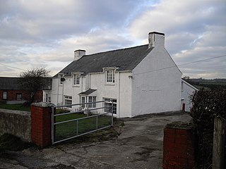
Great Brynhill is a small hamlet and farm in the Vale of Glamorgan in south Wales. It consists little more than a few farms including the Little Brynhill Farm and Thorn Falcon Farm and the Great Brynhill Farm. It is located in the historical parish of Merthyr Dyfan and near Colcot now northern districts of the town of Barry. It is accessed via a lane from Port Road but can also be accessed from Dyffryn along the lane to the New Wallace Farm and Goldsland which lie just to the northeast.

<span class="mw-page-title-main">Pencoedtre</span> District of Barry in Wales

Pencoedtre or Pencoetre, also known as Pencoedtre Village, is a northeastern suburb of Barry in the Vale of Glamorgan, Wales. It borders Gibbonsdown to the southwest and Cadoxton to the south. It has developed from a small farming hamlet into an extensive housing estate in recent years. Pencoedtre Wood is one of the largest areas of woodland in the town, and is a Site of Special Scientific Interest. Pencoedtre Park is located between Pencoedtre and Gibbonsdown.

<span class="mw-page-title-main">Merthyr Tydfil County Borough</span> County borough in Wales

Merthyr Tydfil County Borough is a county borough in the south-east of Wales. In mid 2018, it had an estimated population of 60,183 making it the smallest local authority in Wales by both population and land area. It is located in the historic county of Glamorgan and takes its name from the town with the same name. The county borough consists of the northern part of the Taff Valley and the smaller neighbouring Taff Bargoed Valley. It borders the counties of Rhondda Cynon Taf to the west, Caerphilly County Borough to the east, and Powys to the north.

<span class="mw-page-title-main">Atlantic Trading Estate</span>

The Atlantic Trading Estate is an industrial estate in Barry, Vale of Glamorgan, south Wales, UK. It is situated near the mouth of the Cadoxton River which flows into the Bristol Channel at the Bendricks to the south-east of Barry Docks. It is accessed via the Associated British Port-owned Wimbourne Road from Ffordd-y-Mileniwm near Weston Square, Cadoxton or from the public Hayes Road from the Main B4267 Sully Moors Road, south-west of the village of Sully. It is sometimes considered to be in Sully. It covers an area of 9.22 acres (3.73 ha). It covers an area of 9.22 acres (3.73 ha).

<span class="mw-page-title-main">Dyfan</span>

Saint Dyfan is a highly obscure figure who was presumably the namesake of Merthyr Dyfan and therefore an early Christian saint and martyr in southeastern Wales in Roman or Sub-Roman Britain. He is sometimes styled the protomartyr of Wales. The erection of his martyrium was credited to the 6th-century St Teilo. In the 19th century, Edward Williams conflated him with St Deruvian, a figure in the legendary accounts of the baptism of King Lucius of Britain. The discovery of Williams's alterations and forgeries have since discredited this connection. Partially based on this connection, however, the church of Merthyr Dyfan dates his martyrdom to c. 180.

<span class="mw-page-title-main">Barry Town Council</span>

Barry Town Council is an elected town council serving Barry in the Vale of Glamorgan, one of the largest towns in Wales.

<span class="mw-page-title-main">Thomas Frederick Worrall</span> British painter (b. 1872, d. 1957)

Thomas Frederick Worrall (1872–1957) was a Staffordshire-born manual worker and watercolourist. He lived for a time in Lancashire and in the upper Calder Valley area of Yorkshire but spent most of his adult life in Barry, in South Wales, where he was also deeply involved in politics and stood for parliament in the general election of 1923 representing the Labour Party. He was the elder brother of the pottery and fabric designer William Worrall.

References

  1. http://www.ourbobby.com/EN/PACT/Default.aspx?n1=1&n2=13&n3=131&n4=257&id=101.{{cite web}}: Missing or empty |title= (help)
  2. Moore 1985, p. 65.
  3. Pierce, Gwynedd Owen (1968). The place-names of Dinas Powys Hundred. Published on behalf of the Board of Celtic Studies of the University of Wales [by] University of Wales P. pp. 138–9.
  4. Moore 1985, p. 121.
  5. Moore 1985, p. 155.
  6. Moore 1985, p. 159.
  7. Moore 1985, p. 141.
  8. "About us". Colcotprimary.ik.org. Archived from the original on 11 September 2014. Retrieved 10 September 2014.
  9. Medical Directory. J. & A. Churchill Limited. 2009. p. 3641.
  10. cite web|url=http://www.ukcrimestats.com/Neighbourhood/South_Wales_Police/Dyfan
  11. "Find them!". South Wales Echo. 11 May 2006. Archived from the original on 21 September 2014. Retrieved 10 September 2014.
  12. "'Party' Vandals Take Axe to School Garden". South Wales Echo. 18 April 2007.[ dead link ]
  13. "Family flee after tea light re-ignites and wrecks their living room". South Wales Echo. 17 December 2007. Archived from the original on 21 September 2014. Retrieved 10 September 2014.
  14. "Man's nose broken 'in fight'". South Wales Echo. 28 December 2011. Archived from the original on 21 September 2014. Retrieved 10 September 2014.
  15. "Share your crime fears". South Wales Echo. 21 May 2009. Archived from the original on 21 September 2014. Retrieved 10 September 2014.
  16. Lonely Planet E-Book PDF Wales ReisefŸhrer (in German). Lonely Planet. 1 August 2012. p. 65. ISBN   978-3-8297-8852-6.
  17. "Tour Barry, Gavin and Stacey Style! Town Trail Bid to Tempt Tourists". South Wales Echo. 23 June 2008.[ dead link ]
  18. "Square's Residents in Call for New Shops". South Wales Echo. 3 April 2002.[ dead link ]
  19. "Traders Celebrate after 6-Year Fight". South Wales Echo. 12 October 2005.[ dead link ]
  20. "Hockey: Barry youngsters make it jolly hockey sticks at Colcot". South Wales Echo. 4 June 2008. Archived from the original on 21 September 2014. Retrieved 10 September 2014.
  21. The Golf Guide: Where to Play and Where to Stay in Britain and Ireland. Hunter Publishing, Incorporated. 1 February 2001. p. 459. ISBN   978-1-58843-109-7.
  22. "Barry Is So Proud of Andrew". South Wales Echo. 11 August 2012. Archived from the original on 21 September 2014. Retrieved 10 September 2014.
Bibliography

51°25′08″N3°16′47″W / 51.41889°N 3.27972°W / 51.41889; -3.27972