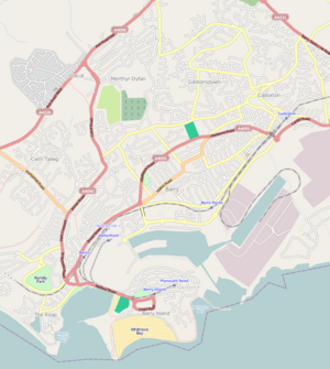
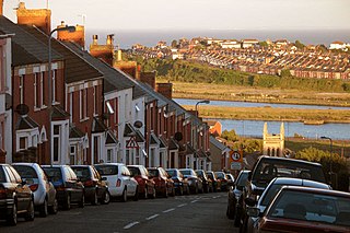
Buttrills

Last updated

Buttrills
District of Barry and ward
Buttrills Road, Barry.jpg
Near the bottom of Buttrills Road, Barry
Buttrills, Barry.png
Map of Buttrills. Click three times to view clearly.
Location map Wales Vale of Glamorgan Barry.png
Red pog.svg
Buttrills
Location in Barry
Coordinates: 51°24′32″N3°16′43″W / 51.40889°N 3.27861°W / 51.40889; -3.27861
Country United Kingdom
Region Wales
County Vale of Glamorgan
Town Barry
Population
 (2011)
  Total6,357
Time zone UTC+0 (GMT)

Buttrills is a northwestern-central district of Barry in the Vale of Glamorgan, in south Wales. It is also an electoral ward of the Vale of Glamorgan, the population of which taken at the 2011 census was 6,357. [1] The centre of education in Barry in the early twentieth century, Buttrills today contains notable playing fields (known as The Butts) and Barry Cemetery.

Contents

History

The Old College The Old College, Barry - geograph.org.uk - 1058815.jpg
The Old College

The origin of the word Buttrills is uncertain. 'Butt' is a word for an archery shooting range, and popular legend has it that the large playing field known as 'the Butt's, adjoining Barry Cemetery, was used as a practice range by archers in the Middle Ages. Welsh longbowmen were renown for their skill, and played a key role in defeating the French at Agincourt in 1415. 'Butt' is also a Middle English word for a strip of land between roads, or a corner or 'rump' of land. 'Rill' means a brook or rivulet, or shallow channel cut into the surface or soil or rocks by running water (a small stream, the Coldbrook, rises in a valley adjoining 'the Butts' to the north).

Before the mid 19th century, Buttrills was a rural area, consisting of several farms. The area in what is now the Barry Memorial Hall and post office at the intersection with Holton Road of Barry once contained two farmhouses, one of them was named Holton Fawr Farm. [2] Butt-Lee Court was erected on what used to be Buttrills Farm and House. Notably it was the home of the Reverend Sims, a close friend of the leader of the anti-slavery campaign, William Wilberforce. [3] The property was sold in 1869 to John Treharne, a wealthy gentleman who also owned Friars Point House and was responsible for building a pier at Barry Island. Treharne completed the house in 1871 but later sold it to the American Consul in Cardiff, Colonel Harry Davies. [3]

Following this, urban sprawl, fuelled by the coaling industry, engulfed the area and by the mid 20th century the area was fully urbanized. During the heavy industrial period, Buttrills Hill was considerably more congested today, with loaded lorries carrying heavy goods; problematic as it was reported to have caused accidents and damage to residential property. [4] St. David's Methodist Church of Barry (now in Colcot) has its origins in the district of Buttrills in the 1920s when a congregation began to meet for worship in two old huts. [3] From around 1920 for a number of years, the British military also ran Buttrills Camp in the area for the treatment and recuperation of the wounded. [5]

The roundabout at the intersection of Barry Road and Colcot Road, which now contains a branch of the Spar was known as "Biddy's" in the 1940s and was popular with pupils at Barry County School. [3]

Geography

Foot of Buttrills Hill Gladstone, Barry1.jpg
Foot of Buttrills Hill

Buttrills borders the district of Colcot to the north and includes territory to the north of Barry Road and south along Buttrills Road, although the precise boundary with the district of Gladstone is unclear. Buttrills Road is particularly steep and connects upper Barry to the western part of the CBD and the downtown district of Holton. Due to its steepness the hill staged several automobile races in the early 20th century which attracts large crowds to the hill. [6] A small stream rises to the northwest Buttrills named Nant Talwg. [2] This flows into western Barry and gave its name to the Nant Talwg housing estate off Pontypridd Road (formerly part of the Five Mile Lane) opposite Cwm Talwg, near Porthkerry Park.

Facilities

Buttrills playing fields (known as The Butts) in the upper part of the district are extensive and today are heavily used for local weekend football matches, both youth and adult, and training. From the late nineteenth century the fields were home to Barry Rovers and Barry Rugby Club. [7] To the east, adjacent to the playing fields, is Barry Cemetery. The major public house of note was once The Old College Inn on the corner of Barry Road and Buttrills Road at the top of the steep hill, named after what was the Old Glamorgan College below. The pub was recently closed for refurbishment, subsequently reopened as a Marston's Inn and renamed 'The Cherry Orchard'. College Fields Nursing Home is located beyond this. To the south are Gladstone Park tennis courts, a bowling centre and Barry Memorial Hall.

Education

In the early twentieth century, Buttrills Hill was the centre of education in Barry. [8] It contained three different schools and colleges at one point run by the Glamorgan Education Committee, including the Glamorgan College of Education and the Barry County School for boys. [8] [9] This school would later evolve into what is now Barry Comprehensive School, now located along Port Road in northern Barry, but was situated on the hill for many years. Glamorgan College of Education was divided into several wings with primary and secondary education, and aside from standard subjects offered specialist courses such as PE for women, a one-year supplementary course in teaching handicapped children, needlework lessons, and oral classes in the Welsh language. [9] The college also contained a library. [10]

Governance

Electoral wards of Barry, with Buttrills in the centre of the town Electoral wards in the town of Barry, Vale of Glamorgan.jpg
Electoral wards of Barry, with Buttrills in the centre of the town

The Buttrills electoral ward is represented by two councillors on the Vale of Glamorgan Council. The ward was previously represented by two Labour councillors, though following the death of councillor Margaret Alexander, one of the seats was taken by Plaid Cymru in a by election on 2 August 2012. [11] Plaid Cymru held the seat at the May 2017 elections. [12] The ward elects three councillors to Barry Town Council. [13]

Related Research Articles

Sully, Vale of Glamorgan Human settlement in Wales

Sully is a village in the community of Sully and Lavernock, in the Vale of Glamorgan, Wales, lying on the northern coast of the Bristol Channel, midway between the towns of Penarth and Barry and 7 miles southwest of the Welsh capital city of Cardiff.

Barry, Vale of Glamorgan Settlement in the Vale of Glamorgan, Wales

Barry is a town in the Vale of Glamorgan, Wales, on the north coast of the Bristol Channel approximately 9 miles (14 km) south-southwest of Cardiff. Barry is a seaside resort, with attractions including several beaches and the resurrected Barry Island Pleasure Park. According to Office for National Statistics 2016 estimate data, the population of Barry was 54,673.

Dinas Powys Human settlement in Wales

Dinas Powys is a large village and a community in the Vale of Glamorgan in South Wales which takes its name from the ancient Welsh for stronghold (Dinas), and pagus (Powys), the Latin word for an outlying or rural settlement. The literal meaning, therefore, being, "Settlement Stronghold", referring to Dinas Powys hillfort, which dates from the Iron Age. The village is 5.6 miles (9.0 km) south-west of the centre of Cardiff and conveniently situated on the A4055 Cardiff to Barry main road, almost merging with Penarth. It is generally regarded as a pleasant dormitory village for Cardiff's commerce and industry commuters since the city has expanded with widespread development around the Cardiff Bay area.

Penrhiwceiber Human settlement in Wales

Penrhiwceiber is a small Welsh village and community in the county borough of Rhondda Cynon Taf that lies south of the town Aberpennar and north of the village of Tyntetown, and is one of many villages that lies within the Cynon Valley. Prior to 1870 the area was heavy woodland, but the opening of the Penrhiwceiber Colliery in 1878 saw its rapid expansion into a thriving village.

Porthkerry Hamlet in the Vale of Glamorgan, Wales

The hamlet of Porthkerry lies on the Bristol Channel coast of South Wales within the community of Rhoose between that village and the town of Barry to the east. It is very close to the end of the runway of Cardiff International Airport. To the east of the hamlet is Porthkerry Country Park which occupies the valley leading down to the coast.

Cardiff Council Local government of Cardiff

The County Council of the City and County of Cardiff has been the governing body for Cardiff, one of the Principal Areas of Wales, since 1996. The council consists of 75 councillors, representing 29 electoral wards. The authority is properly styled as 'the County Council of the City and County of Cardiff' or in common use Cardiff Council. No other style is sanctioned for use on Council Documents although it does occasionally appear wrongly as Cardiff County Council on documents and signage. The City & County itself is usually simply referred to as Cardiff.

Cwm Talwg District of Barry in Wales

Cwm Talwg is a north-western district and large housing estate complex within the town of Barry in the Vale of Glamorgan ten miles outside Cardiff in south Wales.

Gibbonsdown District of Barry in Wales

Gibbonsdown, colloquially known as 'Gibby', is a residential area and electoral ward situated in the north east of Barry in the Vale of Glamorgan, Wales. Gibbonsdown borders Merthyr Dyfan to the northwest and Cadoxton to the southeast.

Llanharry A village in Rhonda Cynon Taff, Wales

Llanharry is a village, community and electoral ward in the county borough of Rhondda Cynon Taf, Wales.

Cadoxton, Vale of Glamorgan District of Barry in Wales

Cadoxton is a district of Barry in the Vale of Glamorgan, Wales. Cadoxton was once originally its own village, separate from Barry. It grew up around Saint Cadoc's parish church, which survives. It is also home to Cadoxton Primary School, situated opposite Victoria Park which in turn is opposite Crystal Springs Conservation Group. The Group was founded in 2005 and campaigned to save the field from housing. Cadoxton Nursery is located beside the primary school.

Trealaw Human settlement in Wales

Trealaw is a long village, also a community and electoral ward in the Rhondda Valley, Rhondda Cynon Taf, Wales. It stretches over two miles from the junction of Cemetery Road and Brithweunydd Road in the east, to the junction of Ynyscynon Road and Partridge Road to the northwest.

2012 Vale of Glamorgan Council election

The 2012 Vale of Glamorgan Council election took place on Thursday 3 May 2012 to elect members of Vale of Glamorgan Council in Wales. This was the same day as other United Kingdom local elections. The previous full council election took place on 1 May 2008 and the next one took place on 4 May 2017.

Pencoedtre District of Barry in Wales

Pencoedtre or Pencoetre, also known as Pencoedtre Village, is a northeastern suburb of Barry in the Vale of Glamorgan, Wales. It borders Gibbonsdown to the southwest and Cadoxton to the south. It has developed from a small farming hamlet into an extensive housing estate in recent years. Pencoedtre Wood is one of the largest areas of woodland in the town, and is a Site of Special Scientific Interest. Pencoedtre Park is located between Pencoedtre and Gibbonsdown.

Dinas Powys is the name of an electoral ward in the Vale of Glamorgan, Wales. It covers its namesake community of Dinas Powys and the neighbouring Michaelston-le-Pit and Leckwith to the north. The ward elects four county councillors to the Vale of Glamorgan Council.

Barry Town Council

Barry Town Council is an elected town council serving Barry in the Vale of Glamorgan, one of the largest towns in Wales.

Castleland

Castleland is an electoral ward in Barry, Vale of Glamorgan, Wales. It elects two county councillors to the Vale of Glamorgan Council.

Court (Barry electoral ward) Electoral ward in Wales

Court is the name of an electoral ward in Barry, Vale of Glamorgan, Wales. It is represented by councillors on Barry Town Council and the Vale of Glamorgan Council.

Cowbridge (electoral ward) Electoral ward in Wales

Cowbridge is the name of an electoral ward in the Vale of Glamorgan, Wales, which covers its namesake town of Cowbridge as well as the neighbouring villages of Llanblethian and Aberthin and the communities of Llanfair and Penllyn. The ward elects three county councillors to the Vale of Glamorgan Council.

The Vale of Glamorgan Association Football League is a football league covering the area of the Vale of Glamorgan in Glamorgan, South Wales and the surrounding areas. The leagues are at the seventh and eighth levels of the Welsh football league system.

References

  1. "Ward population 2011" . Retrieved 9 April 2015.
  2. 1 2 Pierce, Gwynedd Owen (1968). The place-names of Dinas Powys Hundred. University of Wales. Board of Celtic Studies. Published on behalf of the Board of Celtic Studies of the University of Wales [by] University of Wales P. pp. 140–1. Retrieved 27 January 2011.
  3. 1 2 3 4 Clemett, Tom. "History of Barry:A Walk Around". www.barrywales.co.uk. Archived from the original on 20 July 2011. Retrieved 27 January 2011.
  4. Great Britain. Parliament. House of Commons (1974). Parliamentary debates: Official report. H.M. Stationery Off. Retrieved 27 January 2011.
  5. Great Britain. Parliament. House of Commons (1 November 1920). The Parliamentary debates (official report).: House of Commons. H.M.S.O. Retrieved 27 January 2011.
  6. Spooner, Stanley (1908). The Auto: the motorist's pictorial. Pictorial Press. Retrieved 27 January 2011.
  7. Moore, Donald (1985). Barry: the centenary book. Barry Centenary Book Committee. ISBN   978-0-9509738-1-4 . Retrieved 27 January 2011.
  8. 1 2 Glamorgan Local History Society (2006). Morgannwg. Glamorgan History Society. p. 106. Retrieved 27 January 2011.
  9. 1 2 Blishen, Edward (1970). Encyclopedia of education. Philosophical Library. Retrieved 27 January 2011.
  10. Libraries, museums and art galleries year book. J. Clarke [etc.]; New York, R. R. Bowker. 1 January 1976. ISBN   978-0-227-67824-4 . Retrieved 27 January 2011.
  11. "Buttrills, 2012". WelshElections.org.uk. Archived from the original on 9 May 2018. Retrieved 8 May 2018.
  12. Butrills - Declaration Of Result Of Poll, Vale of Glamorgan Council. Retrieved 15 November 2017.
  13. Local Councillors Archived 2018-07-14 at the Wayback Machine , Barry Town Council. Retrieved 15 November 2017.