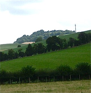
The hillfort
Caerau Hillfort is the third largest Iron Age hillfort in Glamorgan, [3] enclosing 5.1 hectares (13 acres), and is surrounded by housing and the A4232. It was once a stronghold of the powerful Silures tribe who inhabited this part of Wales before the arrival of the Romans.
Excavations for an episode of Channel 4's Time Team , broadcast in April 2012, [4] showed the hillfort's occupation began about 600 BC. [5] Further excavations, in 2013–2014, revealed evidence of the site's occupation back to the early Neolithic. [4] [6] Finds included flint tools and weapons dating to 3600 BC. [6] Iron Age and Romano-British pottery as well as a single fragment of a mortarium (1st century AD Roman pouring vessel) have been found from an area north-west of the southern entrance. [7]
The steep north and south slopes of the ridge are both fortified by three massive ramparts with accompanying ditches, although these are hidden beneath trees and scrub. On the east side the hillfort defences appear to have been reduced to two ramparts in the north and one in south. There seem to have been two entrances to the hillfort, one in the middle of the east side and one west of the south corner. At the east entrance the ramparts curve round to command the approach, but there is no corresponding in turn at the south entrance. An apex in the north-west of the hillfort may be a third entrance, but it has been heavily eroded by water flowing from a spring.
The interior, now pasture, was cultivated in the past, and the characteristic traces of rig and furrow agriculture can be seen on aerial photographs. It is traversed by two earthworks which may be old field boundaries, or even the remains of a smaller, earlier hillfort or even a Neolithic causewayed enclosure.

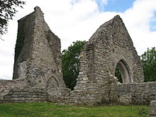
The Diocese of Llandaff is an Anglican diocese that traces its roots to pre-Reformation times as heir of a Catholic bishopric. It is headed by the Bishop of Llandaff, whose seat is located at the Cathedral Church of Saint Peter and Saint Paul in Llandaff, a suburb of Cardiff. It currently covers most of the former Welsh county of Glamorgan, but once stretched from the River Towy to the middle of the Wye Valley.
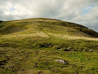
Humbleton Hill is a hill in Northumberland, England, about 1.5 miles (2.4 km) west of Wooler.
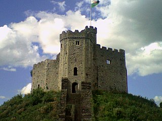
The history of Cardiff—a City and County Borough and the capital of Wales—spans at least 6,000 years. The area around Cardiff has been inhabited by modern humans since the Neolithic Period. Four Neolithic burial chambers stand within a radius of 10 mi (16 km) of Cardiff City Centre, with the St Lythans burial chamber the nearest, at about 4 mi (6.4 km) to the west. Bronze Age tumuli are at the summit of Garth Hill, within the county's northern boundary, and four Iron Age hillfort and enclosure sites have been identified within the City and County of Cardiff boundary, including Caerau Hillfort, an enclosed area of 5.1 ha. Until the Roman conquest of Britain, Cardiff was part of the territory of an Iron Age Celtic British tribe called the Silures, which included the areas that would become known as Brecknockshire, Monmouthshire and Glamorgan. The Roman fort established by the River Taff, which gave its name to the city—Caerdydd, earlier Caerdyf, from caer (fort) and Taf—was built over an extensive settlement that had been established by the Silures in the 50s AD.

The Afon Clun is a 14-mile (23 km) long tributary of the River Ely, in the counties of Cardiff and Rhondda Cynon Taf, Wales. Its bedrock is predominantly of sandstone. Beginning on the western slope of The Garth the river is fast-flowing, in clear shallow water with a hard substrate, flowing to the south of Llantrisant and generally west to its confluence with the River Ely at Pontyclun, falling 715 feet (218 m) over its course.

Moel y Gaer, also known as Moel-y-Gaer Camp or Moel y Gaer Hillfort, is an Iron Age hillfort located on a western spur of the Clwydian Range, near the village of Llanbedr, Denbighshire, Wales. The site is a scheduled monument, classified as a prehistoric defensive hillfort.
Moel y Gaer is an Iron Age hillfort on a summit of Llantysilio Mountain, northwest of the town of Llangollen, Denbighshire, Wales. The site is a scheduled monument classified as a prehistoric defensive hillfort.
Llandyssil is a village in Powys, Wales, about two miles from the town of Montgomery.

Llanilid is a small settlement of in the county borough of Rhondda Cynon Taf, Wales. It is in the historic county of Glamorgan. Llanilid is part of the community of Llanharan along with the villages of Bryncae, Brynna, Ynysmaerdy, Peterston-super-Montem and Llanharan itself.
Ffridd Faldwyn is an Iron Age hillfort in northern Powys, in the former county of Montgomeryshire, It is sited on a prominent hill west of Montgomery, close to but higher than Montgomery Castle, overlooking the River Severn. It is one of the largest hill-forts in Wales.

Clegyr Boia, or Clegyr Fwya, is a prehistoric site on the St David's peninsula, Pembrokeshire, Wales, 33 to 65 feet above the surrounding area. It is about 1 mile (1.6 km) west of St Davids, and about 0.75 miles (1.21 km) east of the Pembrokeshire coast. The hilltop's rocky outcrop contains evidence of Neolithic and Iron Age settlements. The site's nearest water source was Ffynnon Lygaid, a 1 foot (0.30 m) deep pool, fed by a spring. Near the base of the outcrop's southern side, the pool is in a small hollow, measuring about 1 foot (0.30 m) by 8 inches (0.20 m). The site was excavated in 1902 by Sabine Baring-Gould, and by Audrey Williams, for the Ancient Monuments Inspectorate, in 1943.

Craig Ty-Isaf is a small hillfort in Baglan community, Neath Port Talbot, in South Wales. It is one of three hillforts on the area of hillside known as Mynydd y Gaer, and is within Briton Ferry Woods. The hillfort is on the SW side of the hill, overlooking Baglan, an oval enclosing some 0.2ha. A broad rubble bank forms the oval enclosure, and on the east two further banks mean that the area of banks and ditches encompasses a much larger area for the site as a whole, which is a Scheduled Monument. There are various internal features thought to be the result of more recent test cuts for mineral extraction.
Llwynda-Ddu Camp, also known as Llwynda-Ddu Hillfort, is a small Iron Age earthwork in Pentyrch, Cardiff in South Wales. The site is a scheduled monument, described as a prehistoric, defensive hillfort.
Wenallt Camp, also known as Wenallt Enclosure, is an Iron Age enclosure on the southern slope of Wenallt Hill near Rhiwbina in Cardiff, Wales. The site is sometimes classified as a hillfort. The camp is a scheduled monument.
Holkham Camp, or Holkham Fort, is an Iron Age fort in Norfolk, England, about 1 mile (1.6 km) north-west of the village of Holkham. It is a scheduled monument.
Caer Bach is a Welsh hillfort of indeterminate age, on a rounded hillock situated near the village of Rowen; in Conwy County, Wales. Its name in English translates as 'Small Fort'; or alternatively 'Little Fortress'. It is situated on the Eastern slopes of Tal-y-Fan, an outlying peak of the Carneddau mountain range in northeast Snowdonia; at an altitude of approximately 413 metres. Little information is known about the history of the fort, as to date, the site has undergone minimal investigation. The fort is classed as a scheduled ancient monument and is of national importance for its potential to enhance our knowledge of prehistoric settlement. It is said to retain significant archaeological potential, with a strong probability of the presence of associated archaeological features and deposits.

Castell Caer Seion is an Iron Age hillfort situated at the top of Conwy Mountain, in Conwy County, North Wales. It is unusual for the fact that the main fort contains a smaller, more heavily defended fort, complete with its own distinct defences and entrance, with no obvious means of access between the two. The construction date of the original fort is still unknown, but recent excavations have revealed evidence of occupation as early as the 6th century BC, whilst the smaller fort can be dated with reasonable certainty to around the 4th century BC. Whilst the forts were constructed in different periods, archaeologists have uncovered evidence of concurrent occupation, seemingly up until around the 2nd century BC. The larger fort contained around 50 roundhouses during its lifetime, whereas examinations of the smaller fort have turned up no more than six. The site was traditionally associated with Maelgwyn Gwynedd, but there is no evidence pointing to a 6th-century occupation. The fort and wider area beyond its boundaries have been said to retain significant archaeological potential, and are protected by law as a scheduled ancient monument.

Caer Euni [Grid reference SJ 00027 41266] is an Iron Age hillfort, about 2.5 miles (4 km) north-east of the village of Llandderfel and about 5 miles (8 km) north-east of Bala Lake, in Gwynedd, Wales. It is a scheduled monument.

Pentre Camp is an Iron Age hillfort, near the hamlet of Llangynyw and about 2.5 miles (4 km) north-east of Llanfair Caereinion, in Powys, Wales. It is a scheduled monument.