Scheduled monuments in Cardiff
| Image | Name | Site type | Community | Location | Details | Historic County | Period | SAM No & Refs |
|---|---|---|---|---|---|---|---|---|
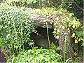 | Cae-yr-Arfau Burial Chamber | Chambered tomb | Pentyrch | 51°31′50″N3°19′54″W / 51.5306°N 3.3317°W , ST077821 | Two upright stones support a large slab of a Neolithic chambered tomb. Having been used in the past as a coal store, it is now overgrown in a garden | Glamorganshire | Prehistoric (Neolithic) | GM030 [3] |
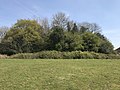
| Five Round Barrows on Garth Hill | Round barrow | Pentyrch | 51°32′37″N3°17′36″W / 51.5436°N 3.2932°W , ST104835 | Glamorganshire | Prehistoric | GM107 [4] | ||
| Cooking Mound East of Taff Terrace | Burnt mound | Radyr and Morganstown | 51°30′45″N3°14′56″W / 51.5126°N 3.2488°W , ST134800 | Glamorganshire | Prehistoric | GM427 [5] | ||
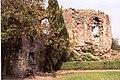
 | Caerau Hillfort | Hillfort | Caerau, (also Ely) | 51°28′03″N3°14′54″W / 51.4675°N 3.2484°W , ST133750 | Hillfort of some 5 ha, with wooded ramparts. Within the Iron Age hillfort are a ruined church (13th century but possibly pre-Norman) and a castle ringwork. Featured in Time Team dig, April 2012 [6] | Glamorganshire | Prehistoric (Iron Age) | GM018 [7] |
| Llwynda-Ddu Camp | Hillfort | Pentyrch | 51°31′15″N3°17′10″W / 51.5209°N 3.2861°W , ST109810 | A small iron age hillfort | Glamorganshire | Prehistoric | GM180 [8] | |
| Castle Field Camp E of Craig-Llywn | Hillfort | Pontprennau | 51°32′58″N3°08′55″W / 51.5494°N 3.1486°W , ST204840 | Glamorganshire | Prehistoric | GM066 [9] | ||
| Wenallt Camp, Rhiwbina | Hillfort | Rhiwbina | 51°32′14″N3°13′26″W / 51.5373°N 3.2239°W , ST152827 | Glamorganshire | Prehistoric | GM097 [10] | ||
 | Cardiff Castle and Roman Fort | Fort | Castle | 51°28′57″N3°10′52″W / 51.4824°N 3.1811°W , ST180765 | Glamorganshire | Roman | GM171 [11] | |
| Pen y lan Roman Site | Settlement | Roath | 51°30′06″N3°09′23″W / 51.5017°N 3.1563°W , ST198787 | Glamorganshire | Roman | GM296 [12] | ||
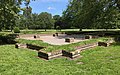
| Ely Roman Villa | Villa | Caerau | 51°28′40″N3°13′46″W / 51.4777°N 3.2295°W , ST147761 | Glamorganshire | Roman | GM205 [13] | ||
 | Cross in Llandaff Cathedral | Cross | Llandaff | 51°29′44″N3°13′03″W / 51.4956°N 3.2176°W , ST155781 | Glamorganshire | Early Medieval | GM115 [14] | |
 | Leckwith Bridge | Bridge | Canton, (also Michaelston) | 51°28′12″N3°12′43″W / 51.4699°N 3.212°W , ST159752 | Glamorganshire | Medieval | GM014 [15] | |
 | Blackfriars Priory (dominican), Bute Park | Friary | Castle | 51°29′00″N3°11′07″W / 51.4832°N 3.1853°W , ST177766 | Glamorganshire | Medieval | GM173 [16] | |
 | Castell Morgraig | Castle | Lisvane, (also Caerphilly) | 51°33′07″N3°12′47″W / 51.5519°N 3.213°W , ST159843 | (Site is on the border with Caerphilly) | Glamorganshire | Medieval | GM031 [17] |
 | Llandaff Cathedral Bell Tower | Bell Tower | Llandaff | 51°29′43″N3°13′07″W / 51.4953°N 3.2186°W , ST154780 | Glamorganshire | Medieval | GM013 [18] | |
 | Old Bishop's Palace, Llandaff | Bishop's Palace | Llandaff | 51°29′40″N3°13′02″W / 51.4945°N 3.2172°W , ST155779 | Glamorganshire | Medieval | GM073 [19] | |
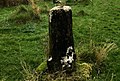 | St Mellons Churchyard Cross | Cross | Old St Mellons | 51°31′33″N3°06′48″W / 51.5258°N 3.1134°W , ST228813 | Monmouthshire | Medieval | MM121 [20] | |
 | Morganstown Castle Mound | Motte | Radyr and Morganstown | 51°31′45″N3°15′28″W / 51.5291°N 3.2579°W , ST128818 | Glamorganshire | Medieval | GM256 [21] | |
 | Twmpath Castle | Motte | Rhiwbina | 51°31′56″N3°13′17″W / 51.5323°N 3.2213°W , ST153822 | Glamorganshire | Medieval | GM017 [22] | |
 | Caer Castell Camp | Motte | Rumney | 51°31′00″N3°06′56″W / 51.5167°N 3.1156°W , ST226803 | Glamorganshire | Medieval | GM216 [23] | |
 | Castell Coch | Castle | Tongwynlais | 51°32′10″N3°15′18″W / 51.536°N 3.2549°W , ST130826 | Glamorganshire | Medieval | GM206 [24] | |
 | Relict Seawall on Rumney Great Wharf | Seawall | Trowbridge | 51°29′45″N3°06′03″W / 51.4958°N 3.1008°W , ST236780 | Glamorganshire | Post-Medieval/Modern | GM474 [25] | |
| | Three Palmerstonian Gun Batteries, Flat Holm | Battery | Butetown | 51°22′47″N3°07′18″W / 51.3798°N 3.1216°W , ST220651 | Glamorganshire | Post-Medieval/Modern | GM351 [26] | |
| Ely Tidal Harbour Coal Staithe Number One | Staithes | Grangetown | 51°26′52″N3°10′58″W / 51.4478°N 3.1827°W , ST179727 | Glamorganshire | Post-Medieval/Modern | GM583 [27] | ||
| The Wreck of the "Louisa" | Boat | Grangetown | 51°27′33″N3°10′46″W / 51.4592°N 3.1795°W , ST181740 | Glamorganshire | Post-Medieval/Modern | GM553 [28] | ||
| Queen Alexandra Dock Harbour Defence Gun Emplacement | Gun House | Butetown | 51°27′07″N3°09′23″W / 51.452°N 3.1564°W , ST197731 | Glamorganshire | Post-Medieval/Modern | GM618 [29] | ||
 | Melingriffith Water Pump | Pump | Whitchurch | 51°30′44″N3°14′16″W / 51.5122°N 3.2378°W , ST142799 | Glamorganshire | Post-Medieval/Modern | GM312 [30] | |
| Flat Holm Coastal and Anti-aircraft Defences | Battery | Butetown | 51°22′35″N3°07′17″W / 51.3765°N 3.1214°W , ST220647 | Glamorganshire | Post-Medieval/Modern | GM595 [31] |

Scheduled monuments in Cardiff, Wales.
 =Prehistoric
  =Roman
  =Early Medieval
 =Medieval
  =Post-Medieval/Modern