
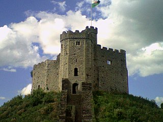
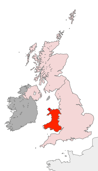
Cardiff is the capital and largest city of Wales. Cardiff had a population of 372,089 in 2022 and forms a principal area officially known as the City and County of Cardiff. The city is the eleventh largest in the United Kingdom. Located in the southeast of Wales and in the Cardiff Capital Region, Cardiff is the county town of the historic county of Glamorgan and in 1974–1996 of South Glamorgan. It belongs to the Eurocities network of the largest European cities. A small town until the early 19th century, its prominence as a port for coal when mining began in the region helped its expansion. In 1905, it was ranked as a city and in 1955 proclaimed capital of Wales. Cardiff Built-up Area covers a larger area outside the county boundary, including the towns of Dinas Powys and Penarth.

Rhiwbina is a suburb and community in the north of Cardiff, the capital of Wales. Formerly a small hamlet within the parish of Whitchurch, Rhiwbina was developed throughout the twentieth century, and is now a separate ward. It retains aspects of its former character, however, and is given a Welsh village appearance by Beulah United Reformed Church at the village crossroads.

Cathays is a district and community in the centre of Cardiff, capital of Wales. It is an old suburb of Cardiff established in 1875. It is densely populated and contains many Victorian terraced houses. The area falls into the Cathays ward. It is the third most populous community in Cardiff, having a population of 18,002 in 2011.

Gabalfa is a district and community in the north of the city of Cardiff, capital of Wales. It is characterised by a four-lane flyover road at the Gabalfa Interchange, where the A48 road meets the A470 road which leads from Cardiff to northern Wales, and the A469 road.

St Mellons is a district and suburb of eastern Cardiff, the capital city of Wales. Prior to 1996 St Mellons was the name given to the community largely north of Newport Road (B4487) which included the old St Mellons village. After 1996 the old community was divided and renamed as Old St Mellons and Pontprennau, with the newer, much larger area of modern housing and business parks to the south of Newport Road retaining the St Mellons name. Historically in Monmouthshire, St Mellons became part of South Glamorgan and Cardiff in 1974.

Carl Wark is a rocky promontory on Hathersage Moor in the Peak District National Park, just inside the boundary of Sheffield, England. The promontory is faced by vertical cliffs on all but one side, which is protected by a prehistoric embankment. The cliffs and embankment form an enclosure that has been interpreted as an Iron Age hill fort, though the date of construction and purpose of the fortifications remains unknown. The site is a scheduled monument.

Rhiwbina railway station is a suburban railway station serving Rhiwbina, Cardiff, Wales. It is located on the Coryton Line 4.25 miles (6.84 km) north of Cardiff Central. Passenger services are provided by Transport for Wales as part of the Valley Lines network. The line is served by the Sprinter classes of DMUs.

Wenallt Hill is located to the north of Cardiff, Wales. The name is Welsh and translates to 'white wooded slope'. Ordnance Survey mapping shows the highest point as 229 m (751 ft), although another source suggests a height of 232 m (761 ft).
The history of Cardiff—a City and County Borough and the capital of Wales—spans at least 6,000 years. The area around Cardiff has been inhabited by modern humans since the Neolithic Period. Four Neolithic burial chambers stand within a radius of 10 mi (16 km) of Cardiff City Centre, with the St Lythans burial chamber the nearest, at about 4 mi (6.4 km) to the west. Bronze Age tumuli are at the summit of Garth Hill, within the county's northern boundary, and four Iron Age hillfort and enclosure sites have been identified within the City and County of Cardiff boundary, including Caerau Hillfort, an enclosed area of 5.1 ha. Until the Roman conquest of Britain, Cardiff was part of the territory of an Iron Age Celtic British tribe called the Silures, which included the areas that would become known as Brecknockshire, Monmouthshire and Glamorgan. The Roman fort established by the River Taff, which gave its name to the city—Caerdydd, earlier Caerdyf, from caer (fort) and Taf—was built over an extensive settlement that had been established by the Silures in the 50s AD.
Scouting in Wales provides an overview of Scouting activities in Wales. Scout troops have existed in the country since 1908 with the largest number of Scouts and volunteer leaders today linked to the Scout Association of the United Kingdom. This is done through ScoutsCymru, the Welsh Scout Council who split the region further into four regions and a total of 12 Scout Areas. In addition to the Scout Association, there are also traditional Scouting groups belonging to the Baden-Powell Scouts' Association and a number of Scouting clubs within Universities which are affiliated to the Student Scout and Guide Organisation.

Scratchbury Camp is the site of an Iron Age univallate hillfort on Scratchbury Hill, overlooking the Wylye valley about 1 km northeast of the village of Norton Bavant in Wiltshire, England. The fort covers an area of 37 acres (15 ha) and occupies the summit of the hill on the edge of Salisbury Plain, with its four-sided shape largely following the natural contours of the hill.

The Bulwarks, Porthkerry is a promontory fort in Rhoose, Vale of Glamorgan, on the southern coast of Wales overlooking the Bristol Channel. It probably dates to the Iron Age and continued to be occupied during the Roman period in Britain. The ramparts and ditches along the west side are well preserved, but the fortifications are heavily overgrown.
Llwynda-Ddu Camp, also known as Llwynda-Ddu Hillfort, is a small Iron Age earthwork in Pentyrch, Cardiff in South Wales. The site is a scheduled monument, described as a prehistoric, defensive hillfort.
Holkham Camp, or Holkham Fort, is an Iron Age fort in Norfolk, England, about 1 mile (1.6 km) north-west of the village of Holkham. It is a scheduled monument.

The Martin Down Enclosure is an archaeological site on Martin Down, near the village of Martin, in Hampshire, England. It is near the boundaries with Dorset and Wiltshire.
Cardiff Corporation Waterworks, its predecessors and successors have provided a public water supply and sewerage and sewage treatment services to the Welsh city of Cardiff since 1850.
Wenallt is the name of several locations in Wales.

Twmpath Castle, also known as Twmpath Motte, is a medieval motte on the southern slope of Wenallt Hill near Rhiwbina in Cardiff, Wales, which is a scheduled monument.
South Lodge Camp is an archaeological site of the Bronze Age, about 0.6 miles (1.0 km) south-east of the village of Tollard Royal, in Wiltshire, England. The site is on Cranborne Chase, near the boundary with Dorset. It is a scheduled monument.
