Scheduled monuments in Denbighshire
| Image | Name | Site type | Community | Location | Details | Historic elisounty | Period | SAM No & Refs |
|---|---|---|---|---|---|---|---|---|
| Bontnewydd Cave | Cave | Cefnmeiriadog | 53°13′38″N3°28′35″W / 53.2271°N 3.4763°W , SJ015710 | Cave excavated in 1985, which found Neanderthal jaw and teeth remains dated to 225,000 years ago, along with stone tools. These are the oldest hominid remains in Wales. | Denbighshire | Prehistoric (palaeolithic) | DE116 [3] | |
| Cefn Caves | Cave | Cefnmeiriadog | 53°13′22″N3°28′07″W / 53.2227°N 3.4685°W , SJ020705 | Network of caves first excavated in the 1830s, finding fragments of stone tools along with numerous animal bones over a wide period, probably accumulated in the caves by water action. | Denbighshire | Prehistoric (palaeolithic and later) | DE115 [4] | |
 | Cae Gwyn Cave | Cave | Tremeirchion | 53°14′29″N3°22′20″W / 53.2414°N 3.3722°W , SJ085724 | Cave with worked flint tools. Dated to 16,000BC. | Flintshire | Prehistoric (palaeolithic) | FL070 [5] |
 | Ffynnon Beuno Cave | Cave | Tremeirchion | 53°14′28″N3°22′19″W / 53.241°N 3.3719°W , SJ085724 | Limestone cave, where flint tools and animal bones have been found. | Flintshire | Prehistoric (palaeolithic) | FL069 [6] |
| Branas-Uchaf Round Barrow | Chambered tomb | Llandrillo | 52°55′34″N3°28′20″W / 52.926°N 3.4723°W , SJ011375 | Chambered tomb with central chamber still in situ, but no capstone. | Merionethshire | Prehistoric (Neolithic) | ME070 [7] | |
| Tyddyn Bleiddyn Burial Chamber | Chambered long cairn | Cefnmeiriadog | 53°14′24″N3°29′20″W / 53.2399°N 3.4889°W , SJ007724 | Two cairns excavated in the mid-19th century. They found numerous crouched inhumations in two cists, with passageways. | Denbighshire | Prehistoric (Neolithic) | DE007 [8] | |
| Tan-y-Coed Burial Chamber | Chambered long cairn | Llandrillo | 52°56′44″N3°25′08″W / 52.9455°N 3.4188°W , SJ047396 | Merionethshire | Prehistoric (Neolithic) | ME048 [9] | ||
| Round Barrow 135m SE of Lodge Farm | Round barrow | Bodfari | 53°14′15″N3°20′32″W / 53.2375°N 3.3423°W , SJ105720 | Flintshire | Prehistoric | FL034 [10] | ||
| Gribin Oernant Cairn | Round barrow | Bryneglwys | 53°00′44″N3°13′41″W / 53.0122°N 3.2281°W , SJ177468 | Denbighshire | Prehistoric | DE271 [11] | ||
| Pant y Maen Round Barrow | Round barrow | Bryneglwys | 53°01′15″N3°15′21″W / 53.0207°N 3.2558°W , SJ158477 | Denbighshire | Prehistoric | DE034 [12] | ||
| Rhos Lydan Round Barrows | Round barrow | Bryneglwys | 53°02′12″N3°15′07″W / 53.0367°N 3.2519°W , SJ161495 | Denbighshire | Prehistoric | DE035 [13] | ||
| Ty Mawr Round Barrows | Round barrow | Bryneglwys | 53°01′29″N3°15′11″W / 53.0248°N 3.2531°W , SJ160482 | Denbighshire | Prehistoric | DE033 [14] | ||
| Bedd Emlyn | Round barrow | Clocaenog | 53°04′05″N3°24′56″W / 53.068°N 3.4155°W , SJ052532 | Denbighshire | Prehistoric | DE201 [15] | ||
| Bryn Beddau Round Barrows | Round barrow | Clocaenog | 53°03′53″N3°25′13″W / 53.0648°N 3.4203°W , SJ049528 | Group of Bronze Age barrows in Clocaenog Forest discovered when forest roads were built in the 1960s. One of the barrows may be a stone circle. The site includes 'Bedd Emlyn' which had an early medieval ogham stone, removed in 1813 and now in the National Museum of Wales. [16] | Denbighshire | Prehistoric (Bronze Age) | DE040 [17] | |
| Bryn Beddau Stone Circle | Stone circle | Clocaenog | 53°03′43″N3°25′24″W / 53.0619°N 3.4232°W , SJ047525 | Prehistoric stone circle of at least 19 stones, within Clocaenog Forest, in a heather-covered clearing. | Denbighshire | Prehistoric | DE245 [18] | |
| Maen Llwyd Standing Stone | Standing stone | Clocaenog | 53°03′36″N3°25′19″W / 53.0601°N 3.4219°W , SJ048523 | Massive stone, 3.4m long, now lying down. It is within Clocaenog Forest. | Denbighshire | Prehistoric | DE255 [19] | |
| Plas Perthi Burial Mound | Round barrow | Clocaenog | 53°04′37″N3°21′00″W / 53.0769°N 3.3499°W , SJ096541 | Denbighshire | Prehistoric | DE192 [20] | ||
| Rug Mound | Round barrow | Corwen | 52°59′02″N3°24′27″W / 52.9839°N 3.4075°W , SJ056438 | Merionethshire | Prehistoric | ME019 [21] | ||
| Two Cairns North of Plasnewydd | Round cairn | Corwen | 52°57′42″N3°17′41″W / 52.9616°N 3.2947°W , SJ131412 | Denbighshire | Prehistoric | DE272 [22] | ||
| Wilderness Round Barrows | Round barrow | Corwen, (also Llangollen), (also Llansantffraid Glyn Ceiriog), (see also Wrexham) | 52°57′14″N3°13′47″W / 52.9539°N 3.2298°W , SJ174403 | Denbighshire | Prehistoric | DE092 [23] | ||
| Round Barrow 400m SE of Tai Marian | Round barrow | Cwm | 53°17′01″N3°23′15″W / 53.2836°N 3.3876°W , SJ075771 | Flintshire | Prehistoric | FL041 [24] | ||
| Three Round Barrows in Cwm Wood | Round barrow | Cwm | 53°16′43″N3°23′12″W / 53.2785°N 3.3866°W , SJ076766 | Flintshire | Prehistoric | FL192 [25] | ||
| Capel Hiraethog Earth Circles | Ring cairn | Cyffylliog | 53°04′48″N3°26′25″W / 53.0801°N 3.4402°W , SJ036546 | Denbighshire | Prehistoric | DE043 [26] | ||
| Capel Hiraethog Round Barrow | Round barrow | Cyffylliog | 53°04′44″N3°26′44″W / 53.0789°N 3.4455°W , SJ032544 | Denbighshire | Prehistoric | DE042 [27] | ||
| Moel yr Henfaes Cairn Cemetery | Round cairn | Cynwyd | 52°56′34″N3°23′22″W / 52.9428°N 3.3894°W , SJ067392 | Merionethshire | Prehistoric | DE301 [28] | ||
| Moel yr Henfaes Ring Cairn | Ring cairn | Cynwyd | 52°56′16″N3°22′41″W / 52.9377°N 3.3781°W , SJ074387 | Merionethshire | Prehistoric | DE299 [29] | ||
| Nant Croes-y-wernen Stone Circle | Stone circle | Cynwyd | 52°56′29″N3°20′37″W / 52.9414°N 3.3435°W , SJ098390 | Merionethshire | Prehistoric | DE300 [30] | ||
| Garw Fynydd Cairn | Platform Cairn | Derwen | 53°02′52″N3°24′48″W / 53.0479°N 3.4134°W , SJ053510 | Denbighshire | Prehistoric | DE274 [31] | ||
| Coed Plas Round Barrow | Round barrow | Henllan | 53°12′24″N3°26′59″W / 53.2067°N 3.4498°W , SJ032687 | Denbighshire | Prehistoric | DE050 [32] | ||
| Old Foxhall Round Barrow | Round barrow | Henllan | 53°11′41″N3°26′53″W / 53.1948°N 3.4481°W , SJ033673 | Denbighshire | Prehistoric | DE052 [33] | ||
| Plas Heaton Round Barrow | Round barrow | Henllan | 53°12′20″N3°26′59″W / 53.2055°N 3.4496°W , SJ032685 | Denbighshire | Prehistoric | DE049 [34] | ||
| Plas-Meifod Round Barrow | Round barrow | Henllan | 53°12′07″N3°27′26″W / 53.2019°N 3.4573°W , SJ027681 | Denbighshire | Prehistoric | DE051 [35] | ||
| Moel y Plas Round Barrow | Round barrow | Llanarmon-yn-Ial | 53°05′23″N3°14′25″W / 53.0897°N 3.2404°W , SJ170554 | Denbighshire | Prehistoric | DE062 [36] | ||
| Tyn-y-Mynydd Round Barrow | Round barrow | Llanarmon-yn-Ial | 53°05′36″N3°14′37″W / 53.0934°N 3.2435°W , SJ168558 | Denbighshire | Prehistoric | DE061 [37] | ||
| Moel Eithinen Round Barrow | Round barrow | Llanbedr Dyffryn Clwyd | 53°07′21″N3°15′34″W / 53.1224°N 3.2595°W , SJ158591 | Denbighshire | Prehistoric | DE280 [38] | ||
| Moel Gyw Round Barrow | Round barrow | Llanbedr Dyffryn Clwyd | 53°06′31″N3°14′21″W / 53.1086°N 3.2391°W , SJ171575 | Denbighshire | Prehistoric | DE063 [39] | ||
| Mynydd Cricor Barrow | Round barrow | Llanbedr Dyffryn Clwyd | 53°02′37″N3°16′26″W / 53.0435°N 3.2738°W , SJ146503 | Denbighshire | Prehistoric | DE266 [40] | ||
| Abersychnant Cairn | Round barrow | Llandegla | 53°02′19″N3°08′35″W / 53.0385°N 3.143°W , SJ234496 | Denbighshire | Prehistoric | DE264 [41] | ||
| Cas-Gan-Ditw Round Barrow | Round barrow | Llandegla | 53°03′49″N3°08′49″W / 53.0637°N 3.1469°W , SJ232524 | Denbighshire | Prehistoric | DE169 [42] | ||
| Cefn y Cist Cairn | Round barrow | Llandegla | 53°01′47″N3°08′12″W / 53.0297°N 3.1366°W , SJ238486 | Denbighshire | Prehistoric | DE269 [43] | ||
| Cefn y Gader Round Barrows | Round barrow | Llandegla, (also Penycae), (also Minera), (see also Wrexham) | 53°02′21″N3°08′18″W / 53.0393°N 3.1384°W , SJ237497 | Denbighshire | Prehistoric | DE070 [44] | ||
| Craig-y-Forwyn Cairn | Round cairn | Llandegla | 53°01′29″N3°08′20″W / 53.0246°N 3.139°W , SJ236480 | Denbighshire | Prehistoric | DE267 [45] | ||
| Cryn-y-Brain Round Barrow | Round barrow | Llandegla | 53°01′49″N3°09′08″W / 53.0303°N 3.1523°W , SJ228487 | Denbighshire | Prehistoric | DE270 [46] | ||
| Cyrn y Brain Round Barrows | Round barrow | Llandegla | 53°02′18″N3°10′29″W / 53.0384°N 3.1747°W , SJ213496 | Denbighshire | Prehistoric | DE065 [47] | ||
| Llyn Cyfnwy Round Barrow | Round barrow | Llandegla | 53°05′03″N3°10′28″W / 53.0842°N 3.1745°W , SJ214547 | Denbighshire | Prehistoric | DE064 [48] | ||
| Maes Maelor Round Barrow | Round barrow | Llandegla | 53°03′55″N3°08′48″W / 53.0653°N 3.1466°W , SJ232526 | Denbighshire | Prehistoric | DE056 [49] | ||
| Rhos-Ddigre Caves | Cave | Llandegla | 53°04′25″N3°12′49″W / 53.0737°N 3.2135°W , SJ187536 | Group of 5 caves with Bronze Age burials | Denbighshire | Prehistoric (Bronze Age) | DE119 [50] | |
| Blaen Llynor Round Cairn | Round cairn | Llandrillo | 52°55′13″N3°21′44″W / 52.9203°N 3.3622°W , SJ085367 | Merionethshire | Prehistoric | DE302 [51] | ||
| Cader Bronwen Round Barrow | Round barrow | Llandrillo | 52°54′05″N3°22′22″W / 52.9014°N 3.3729°W , SJ077346 | Denbighshire | Prehistoric | DE060 [52] | ||
| Cairns, Settlements & Field Systems of Prehistoric & Medieval date at Pennant above Nant Esgeiriau | Ring cairn | Llandrillo | 52°53′18″N3°25′03″W / 52.8884°N 3.4175°W , SJ047332 | Merionethshire | Prehistoric | ME146 [53] | ||
| Carnedd y Ci Barrow | Round cairn | Llandrillo | 52°53′40″N3°24′18″W / 52.8945°N 3.405°W , SJ055339 | Denbighshire | Prehistoric | DE260 [54] | ||
| Cefn Penagored Cairn and Ring Cairn | Kerb cairn | Llandrillo | 52°53′29″N3°25′47″W / 52.8914°N 3.4298°W , SJ038336 | Denbighshire | Prehistoric | DE257 [55] | ||
| Cefn Penagored Ridge Cairns | Kerb cairn | Llandrillo | 52°53′28″N3°25′36″W / 52.891°N 3.4267°W , SJ041335 | Denbighshire | Prehistoric | DE256 [56] | ||
| Moel Sych Round Barrow | Round barrow | Llandrillo, (also Llanrhaeadr-ym-Mochnant), (see also Powys) | 52°52′34″N3°23′19″W / 52.8761°N 3.3887°W , SJ066318 | Denbighshire | Prehistoric | DE067 [57] | ||
| Moel Ty-Uchaf Circles | Stone circle | Llandrillo | 52°55′24″N3°24′18″W / 52.9232°N 3.4051°W , SJ056371 | A circle of 43 stones, probably representing the kerbs of a burial mound. A central hollow could be a robbed-out grave. | Merionethshire | Prehistoric | ME013 [58] | |
| Nant Esgeiriau Cairn | Round cairn | Llandrillo | 52°53′08″N3°25′20″W / 52.8856°N 3.4221°W , SJ044329 | Denbighshire | Prehistoric | DE259 [59] | ||
| Nant Gwyn Round Cairns | Round cairn | Llandrillo | 52°55′24″N3°22′25″W / 52.9234°N 3.3737°W , SJ077371 | Merionethshire | Prehistoric | DE305 [60] | ||
| Pennant Cairns | Round barrow | Llandrillo | 52°53′20″N3°25′27″W / 52.889°N 3.4241°W , SJ042333 | Denbighshire | Prehistoric | DE258 [61] | ||
| Ring Cairn E of Ffridd Camen | Ring cairn | Llandrillo | 52°53′57″N3°25′03″W / 52.8992°N 3.4175°W , SJ047344 | Merionethshire | Prehistoric | ME147 [62] | ||
| Two Ring Cairns West of Cwm Tywyll | Ring cairn | Llandrillo | 52°53′38″N3°25′37″W / 52.8939°N 3.4269°W , SJ041338 | Merionethshire | Prehistoric | ME145 [63] | ||
| Tyfos Stone Circle | Stone circle | Llandrillo | 52°56′15″N3°26′49″W / 52.9374°N 3.447°W , SJ028388 | Thirteen recumbent stones define the kerb of a cairn | Merionethshire | Prehistoric (Bronze Age) | ME024 [64] | |
| Tom Dongen Round Barrow | Round barrow | Llanelidan | 53°01′53″N3°19′22″W / 53.0315°N 3.3229°W , SJ113490 | Denbighshire | Prehistoric | DE072 [65] | ||
| Cefn Coch Tumulus | Round barrow | Llanfair Dyffryn Clwyd | 53°06′08″N3°17′02″W / 53.1022°N 3.2839°W , SJ141568 | Denbighshire | Prehistoric | DE265 [66] | ||
| Moel Llech Round Barrow | Round barrow | Llanfair Dyffryn Clwyd | 53°05′37″N3°14′38″W / 53.0935°N 3.2438°W , SJ168558 | Denbighshire | Prehistoric | DE108 [67] | ||
| Ffynnon-Las Wood Round Barrow | Round barrow | Llangollen | 52°57′37″N3°11′56″W / 52.9603°N 3.1988°W , SJ195409 | Denbighshire | Prehistoric | DE091 [68] | ||
| Circular Platforms North West of Hen Ddinbych | Platform Cairn | Llanrhaeadr-yng-Nghinmeirch | 53°05′48″N3°30′37″W / 53.0967°N 3.5102°W , SH989565 | Denbighshire | Prehistoric | DE087 [69] | ||
| Twr yr Hill Round Barrow | Round barrow | Llanrhaeadr-yng-Nghinmeirch | 53°06′42″N3°28′44″W / 53.1117°N 3.479°W , SJ010581 | Denbighshire | Prehistoric | DE088 [70] | ||
| Craig Arthur Kerb Cairn | Kerb cairn | Llantysilio | 53°00′55″N3°09′33″W / 53.0153°N 3.1593°W , SJ223470 | Denbighshire | Prehistoric | DE262 [71] | ||
| Creigiau Eglwyseg Cairn | Round cairn | Llantysilio | 52°59′31″N3°09′39″W / 52.992°N 3.1608°W , SJ221444 | Denbighshire | Prehistoric | DE261 [72] | ||
| Creigiau Eglwyseg Round Barrow | Round barrow | Llantysilio | 52°59′56″N3°08′59″W / 52.9988°N 3.1496°W , SJ229452 | Denbighshire | Prehistoric | DE079 [73] | ||
| Creigiau Eglwyseg Round Barrows & Earth Circle | Round barrow | Llantysilio | 52°59′46″N3°09′35″W / 52.9962°N 3.1598°W , SJ222449 | Denbighshire | Prehistoric | DE081 [74] | ||
| Creigiau Eglwyseg Stone Circle | Stone circle | Llantysilio | 52°59′52″N3°09′05″W / 52.9979°N 3.1515°W , SJ228451 | Possible stone circle, or kerbs of a cairn. | Denbighshire | Prehistoric | DE080 [75] | |
| Eglwyseg Mountain Round Barrow | Round barrow | Llantysilio, (also Penycae), (see also Wrexham) | 53°00′31″N3°08′49″W / 53.0086°N 3.147°W , SJ231463 | Denbighshire | Prehistoric | DE066 [76] | ||
 | Eliseg's Pillar | Round barrow with inscribed pillar | Llantysilio | 52°59′32″N3°11′21″W / 52.9921°N 3.1893°W , SJ202445 | Erected by Cyngen ap Cadell (died 855), king of Powys in honour of his great-grandfather Elisedd ap Gwylog. The form Eliseg found on the pillar is thought to be a mistake by the carver of the inscription. The pillar stands on a Bronze Age burial mound. | Denbighshire | Prehistoric | DE015 [77] |
| Moel Gamelin Round Barrow | Round barrow | Llantysilio | 53°00′35″N3°13′45″W / 53.0096°N 3.2291°W , SJ176465 | Denbighshire | Prehistoric | DE068 [78] | ||
| Rhewl Round Barrows | Round barrow | Llanynys | 53°07′58″N3°19′34″W / 53.1329°N 3.3261°W , SJ113603 | Denbighshire | Prehistoric | DE167 [79] | ||
| Bwlch-Du Round Barrow | Round barrow | Nantglyn | 53°06′36″N3°30′41″W / 53.11°N 3.5114°W , SH989580 | Denbighshire | Prehistoric | DE085 [80] | ||
| Gorsedd Bran Round Barrows | Platform Cairn | Nantglyn | 53°07′47″N3°32′06″W / 53.1296°N 3.5351°W , SH973602 | Denbighshire | Prehistoric | DE168 [81] | ||
| Round Barrow at Coed Bell, Gronant | Round barrow | Prestatyn | 53°20′06″N3°22′18″W / 53.3351°N 3.3718°W , SJ087828 | Flintshire | Prehistoric | FL188 [82] | ||
| Round Barrow West of Ty Draw | Round barrow | Prestatyn | 53°19′08″N3°23′51″W / 53.319°N 3.3976°W , SJ069811 | Flintshire | Prehistoric | FL112 [83] | ||
| Castle Farm Round Barrow | Round barrow | Ruthin | 53°06′45″N3°18′27″W / 53.1126°N 3.3075°W , SJ125580 | Denbighshire | Prehistoric | DE105 [84] | ||
| Criafol Round Barrow | Round barrow | Tremeirchion | 53°16′27″N3°21′41″W / 53.2742°N 3.3614°W , SJ093761 | Flintshire | Prehistoric | FL170 [85] | ||
| Round Barrow 270m NW of Traveller's Inn | Round barrow | Tremeirchion | 53°16′22″N3°20′06″W / 53.2727°N 3.335°W , SJ110759 | Flintshire | Prehistoric | FL047 [86] | ||
| Round Barrow 800m NE of Criafol Farm | Round barrow | Tremeirchion | 53°16′47″N3°20′57″W / 53.2797°N 3.3492°W , SJ101767 | Flintshire | Prehistoric | FL048 [87] | ||
| Two Round Barrows on Moel Maen Efa | Round barrow | Tremeirchion | 53°15′30″N3°22′13″W / 53.2583°N 3.3703°W , SJ086743 | Flintshire | Prehistoric | FL049 [88] | ||
| Coed Clwyd Cairns | Round barrow | Waen | 53°08′33″N3°15′27″W / 53.1424°N 3.2576°W , SJ159613 | Denbighshire | Prehistoric | DE248 [89] | ||
| Dinas Melin-y-Wig | Hillfort | Betws Gwerfil Goch | 53°01′52″N3°25′09″W / 53.0312°N 3.4193°W , SJ049491 | Merionethshire | Prehistoric | ME014 [90] | ||
| Mynydd Rhyd Ddu Enclosure | Hillfort | Betws Gwerfil Goch | 53°01′07″N3°24′37″W / 53.0187°N 3.4104°W , SJ054477 | Denbighshire | Prehistoric | DE252 [91] | ||
| Moel y Gaer | Hillfort | Bodfari | 53°13′35″N3°21′24″W / 53.2265°N 3.3568°W , SJ095707 | Flintshire | Prehistoric | FL073 [92] | ||
 | Moel y Gaer, Cefn | Hillfort | Bryneglwys | 53°00′29″N3°14′34″W / 53.0081°N 3.2428°W , SJ167463 | Denbighshire | Prehistoric | DE126 [93] | |
 | Bedd-y-Cawr Hillfort | Hillfort | Cefnmeiriadog | 53°14′11″N3°28′48″W / 53.2364°N 3.4799°W , SJ013720 | Hillfort on natural inland promontory with ditch and bank and an area of 0.8 hectares (2.0 acres) | Denbighshire | Prehistoric | DE037 [94] |
| Pont Petryal Caerau Circles | Enclosure | Clocaenog | 53°03′29″N3°25′44″W / 53.0581°N 3.429°W , SJ043521 | Denbighshire | Prehistoric | DE041 [95] | ||
| Bwrdd y Tri Arglwydd Boundary Stone | Boundary stone | Corwen | 53°00′40″N3°20′11″W / 53.011°N 3.3364°W , SJ104468 | Possible remnant of a cromlech, or a medieval boundary stones. It is at the junction of four parishes. | Merionethshire | Prehistoric | ME025 [96] | |
| Caer Drewen Camp | Hillfort | Corwen | 52°59′21″N3°21′36″W / 52.9892°N 3.3601°W , SJ087444 | Merionethshire | Prehistoric | ME012 [97] | ||
| Moel Fodig Camp | Hillfort | Corwen | 53°00′03″N3°20′54″W / 53.0007°N 3.3482°W , SJ096456 | Merionethshire | Prehistoric | ME051 [98] | ||
| Y Garth Camp | Enclosure | Cyffylliog | 53°07′03″N3°22′30″W / 53.1174°N 3.3751°W , SJ080586 | Denbighshire | Prehistoric | DE103 [99] | ||
| Gwerclas Mound | Mound | Cynwyd | 52°58′06″N3°24′36″W / 52.9682°N 3.4101°W , SJ053421 | Merionethshire | Prehistoric | ME069 [100] | ||
| Y Gaerwen Enclosure, Llangar | Enclosure | Cynwyd | 52°57′17″N3°26′59″W / 52.9547°N 3.4498°W , SJ027406 | Merionethshire | Prehistoric | ME091 [101] | ||
| Moel Hiraddug Hillfort | Hillfort | Dyserth | 53°17′37″N3°24′21″W / 53.2937°N 3.4057°W , SJ064783 | Flintshire | Prehistoric | FL012 [102] | ||
| Craig Adwywynt Camp | Hillfort | Efenechtyd | 53°04′45″N3°18′46″W / 53.0793°N 3.3129°W , SJ121543 | Denbighshire | Prehistoric | DE073 [103] | ||
| Pen-y-Gaer Camp | Hillfort | Efenechtyd | 53°05′00″N3°20′11″W / 53.0832°N 3.3364°W , SJ105548 | Denbighshire | Prehistoric | DE045 [104] | ||
| | Moel Fenlli Camp | Hillfort | Llanbedr Dyffryn Clwyd | 53°07′53″N3°15′08″W / 53.1314°N 3.2523°W , SJ163600 | Denbighshire | Prehistoric | DE009 [105] | |
 | Moel-y-Gaer Camp | Hillfort | Llanbedr Dyffryn Clwyd | 53°08′46″N3°16′27″W / 53.146°N 3.2742°W , SJ148617 | An oval Iron Age hillfort overlooking the Vale of Clwyd. | Denbighshire | Prehistoric | DE010 [106] |
| Craig yr Uchain | Enclosure | Llandrillo | 52°55′04″N3°27′08″W / 52.9179°N 3.4523°W , SJ024366 | Denbighshire | Prehistoric | DE230 [107] | ||
| Platform Settlement by Clochnant E of Cadwst | Unenclosed hut circle | Llandrillo | 52°54′21″N3°25′07″W / 52.9058°N 3.4186°W , SJ046352 | Merionethshire | Prehistoric | ME148 [108] | ||
| Moel Arthur Camp | Hillfort | Llandyrnog, (also Nannerch), (see also Flintshire) | 53°11′05″N3°16′50″W / 53.1846°N 3.2806°W , SJ145660 | Flintshire | Prehistoric | FL010 [109] | ||
| Pen-y-Cloddiau Camp | Hillfort | Llandyrnog, (also Ysceifiog), (see also Flintshire) | 53°11′55″N3°18′19″W / 53.1986°N 3.3054°W , SJ128676 | Flintshire | Prehistoric | FL009 [110] | ||
| Prestatyn Roman Site | Settlement | Prestatyn | 53°19′31″N3°24′37″W / 53.3253°N 3.4104°W , SJ061818 | Flintshire | Roman | FL094 [111] | ||
| Blaen-y-Cwm Inscribed Stone (Now in Llandrillo Church) | Inscribed stone | Llandrillo | 52°55′20″N3°26′16″W / 52.9223°N 3.4379°W , SJ034370 | Merionethshire | Roman | ME066 [112] | ||
| Plas-newydd Romano-British temple cropmark | Temple | Llanfair Dyffryn Clwyd | 53°05′31″N3°17′24″W / 53.0919°N 3.2901°W , SJ137557 | Denbighshire | Roman | DE289 [113] | ||
| Ffynnon Fair (Well), Cefn | Holy Well | Cefnmeiriadog | 53°13′40″N3°27′21″W / 53.2278°N 3.4557°W , SJ029710 | Denbighshire | Medieval | DE038 [114] | ||
| Corwen Churchyard Cross | Cross | Corwen | 52°58′48″N3°22′25″W / 52.98°N 3.3736°W , SJ079433 | Merionethshire | Medieval | ME052 [115] | ||
 | Owain Glyndwr's Mount | Motte | Corwen | 52°58′41″N3°18′17″W / 52.9781°N 3.3046°W , SJ125431 | Merionethshire | Medieval | ME017 [116] | |
| Coed Llynor Long Hut | Deserted Rural Settlement | Cynwyd | 52°55′27″N3°23′06″W / 52.9242°N 3.3851°W , SJ069372 | Merionethshire | Medieval | DE304 [117] | ||
 | Llangar Old Parish Church | Church | Cynwyd | 52°58′16″N3°23′45″W / 52.9712°N 3.3959°W , SJ063424 | Merionethshire | Medieval | ME093 [118] | |
| Coed Clattwn Moated Site | Moated Site | Denbigh | 53°12′27″N3°25′52″W / 53.2076°N 3.431°W , SJ045687 | Denbighshire | Medieval | DE234 [119] | ||
 | Denbigh Castle and Medieval Town | Castle | Denbigh | 53°10′50″N3°25′14″W / 53.1806°N 3.4206°W , SJ051657 | Denbighshire | Medieval | DE156 [120] | |
 | Denbigh Friary | Friary | Denbigh | 53°11′16″N3°24′33″W / 53.1878°N 3.4091°W , SJ059665 | Denbighshire | Medieval | DE023 [121] | |
 | Denbigh Medieval Town (North - Eastern Corner) | Town | Denbigh | 53°10′54″N3°25′09″W / 53.1816°N 3.4191°W , SJ052658 | Denbighshire | Medieval | DE225 [122] | |
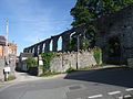
 | Denbigh Town Walls | Town defences | Denbigh | 53°10′51″N3°25′09″W / 53.1808°N 3.4191°W , SJ052657 | Denbighshire | Medieval | DE002 [123] | |
| Llys Gwenllian Mound & Bailey | Motte & Bailey | Denbigh | 53°10′06″N3°24′47″W / 53.1682°N 3.4131°W , SJ056643 | Denbighshire | Medieval | DE019 [124] | ||
 | Denbigh, St Hilary's Chapel | Tower | Denbigh | 53°10′54″N3°25′11″W / 53.1818°N 3.4198°W , SJ052659 | Denbighshire | Medieval | DE005 [125] | |
| Derwen Churchyard Cross | Cross | Derwen | 53°02′45″N3°23′18″W / 53.0457°N 3.3882°W , SJ070507 | Denbighshire | Medieval | DE162 [126] | ||
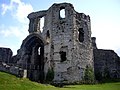
| Dyserth Castle | Castle | Dyserth | 53°18′28″N3°24′40″W / 53.3079°N 3.4111°W , SJ060799 | Flintshire | Medieval | FL130 [127] | ||
| Siamber-Wen Medieval House | House (domestic) | Dyserth | 53°18′21″N3°24′36″W / 53.3057°N 3.4101°W , SJ061796 | Flintshire | Medieval | FL063 [128] | ||
| Old Foxhall Earth Circle | Enclosure | Henllan | 53°11′42″N3°26′47″W / 53.195°N 3.4465°W , SJ034674 | Denbighshire | Medieval | DE053 [129] | ||
| Pysgodlan Moated Site | Moated Site | Henllan | 53°12′44″N3°26′22″W / 53.2122°N 3.4394°W , SJ039693 | Denbighshire | Medieval | DE200 [130] | ||
| Tomen y Faerdre Castle Mound | Motte | Llanarmon-yn-Ial | 53°05′47″N3°12′22″W / 53.0964°N 3.2062°W , SJ193561 | Denbighshire | Medieval | DE006 [131] | ||
 | Churchyard Cross, St Meugan's Church | Cross | Llanbedr Dyffryn Clwyd | 53°06′36″N3°17′10″W / 53.11°N 3.2861°W , SJ140577 | Denbighshire | Medieval | DE188 [132] | |
| Tomen y Rhodwydd (Castell yr Adwy) Mound and Bailey Castle | Motte & Bailey | Llandegla | 53°03′19″N3°13′46″W / 53.0553°N 3.2294°W , SJ176516 | Denbighshire | Medieval | DE018 [133] | ||
| Cwm Tywyll House Platforms | House platform | Llandrillo | 52°53′40″N3°25′09″W / 52.8944°N 3.4192°W , SJ046339 | Denbighshire | Medieval | DE249 [134] | ||
| Ffridd Camen Hafodydd | Platform house | Llandrillo | 52°54′01″N3°25′21″W / 52.9003°N 3.4225°W , SJ044345 | Denbighshire | Medieval | DE250 [135] | ||
| Ffridd Camen Long Hut | Rectangular hut | Llandrillo | 52°54′07″N3°25′17″W / 52.9019°N 3.4213°W , SJ044347 | Denbighshire | Medieval | DE251 [136] | ||
| Ffridd yr Eglwys Deserted Rural Settlement | Rectangular hut | Llandrillo | 52°53′24″N3°26′10″W / 52.8899°N 3.4361°W , SJ034334 | Denbighshire | Medieval | DE254 [137] | ||
| Gwern Wynodl Hafod | Platform house | Llandrillo | 52°54′29″N3°25′20″W / 52.908°N 3.4223°W , SJ044354 | Denbighshire | Medieval | DE247 [138] | ||
| Nant Gwyn Long Hut | Deserted Rural Settlement | Llandrillo | 52°55′34″N3°23′14″W / 52.9261°N 3.3872°W , SJ068374 | Merionethshire | Medieval | DE306 [139] | ||
| Coed Henblas Moated Site | Moated Site | Llanfair Dyffryn Clwyd | 53°05′13″N3°16′29″W / 53.087°N 3.2748°W , SJ147551 | Denbighshire | Medieval | DE232 [140] | ||
| Castell Dinas Bran | Castle | Llangollen | 52°58′44″N3°09′30″W / 52.979°N 3.1584°W , SJ223430 | Denbighshire | Medieval | DE021 [141] | ||
 | Llangollen Bridge | Bridge | Llangollen | 52°58′16″N3°10′13″W / 52.971°N 3.1702°W , SJ215421 | Denbighshire | Medieval | DE026 [142] | |
| Hen Ddinbych Circular Platforms | Enclosure | Llanrhaeadr-yng-Nghinmeirch | 53°05′42″N3°30′33″W / 53.0949°N 3.5093°W , SH990563 | Denbighshire | Medieval | DE086 [143] | ||
 | Valle Crucis Abbey | Abbey | Llantysilio | 52°59′20″N3°11′12″W / 52.9888°N 3.1867°W , SJ204441 | Denbighshire | Medieval | DE003 [144] | |
| Prestatyn Castle | Castle | Prestatyn | 53°20′18″N3°23′39″W / 53.3383°N 3.3943°W , SJ072833 | An earth mound south of Prestatyn railway station. | Flintshire | Medieval | FL024 [145] | |
| Criccin Cross | Cross shaft | Rhuddlan | 53°16′57″N3°26′23″W / 53.2826°N 3.4396°W , SJ041771 | Flintshire | Medieval | FL102 [146] | ||
| Part of site of Rhuddlan Norman Borough | Town | Rhuddlan | 53°17′18″N3°27′42″W / 53.2882°N 3.4617°W , SJ026778 | Flintshire | Medieval | FL129 [147] | ||
| | Rhuddlan Bridge | Bridge | Rhuddlan | 53°17′24″N3°28′08″W / 53.2899°N 3.4689°W , SJ021779 | Flintshire | Medieval | FL018 [148] | |
 | Rhuddlan Castle | Castle | Rhuddlan | 53°17′21″N3°27′54″W / 53.2891°N 3.465°W , SJ024779 | Flintshire | Medieval | FL004 [149] | |
| Rhuddlan Town Banks | Town defences | Rhuddlan | 53°17′33″N3°28′05″W / 53.2925°N 3.468°W , SJ022782 | Flintshire | Medieval | FL068 [150] | ||
| Twthill, Rhuddlan | Motte & Bailey | Rhuddlan | 53°17′14″N3°27′43″W / 53.2871°N 3.4619°W , SJ026776 | Flintshire | Medieval | FL015 [151] | ||
| Ffynogion Moated Site | Moated Site | Ruthin | 53°05′45″N3°18′12″W / 53.0958°N 3.3032°W , SJ128561 | Denbighshire | Medieval | DE074 [152] | ||
 | Ruthin Castle | Castle | Ruthin | 53°06′45″N3°18′42″W / 53.1124°N 3.3116°W , SJ123580 | Denbighshire | Medieval | DE022 [153] | |
| Deeside Slateworks | Water Power System | Corwen | 52°58′07″N3°16′08″W / 52.9686°N 3.269°W , SJ148420 | Denbighshire | Post-Medieval/Modern | DE246 [154] | ||
| Pont Carrog | Bridge | Corwen | 52°59′01″N3°19′09″W / 52.9835°N 3.3192°W , SJ115437 | Merionethshire | Post-Medieval/Modern | ME029 [155] | ||
| Rhug ornamental wrought iron gates | Gate | Corwen | 52°58′57″N3°24′35″W / 52.9824°N 3.4097°W , SJ054437 | Merionethshire | Post-Medieval/Modern | ME047 [156] | ||
 | Rug Chapel | Chapel | Corwen | 52°59′03″N3°23′39″W / 52.9842°N 3.3942°W , SJ064438 | Merionethshire | Post-Medieval/Modern | ME089 [157] | |
| Pont Dyfrdwy | Bridge | Cynwyd | 52°57′37″N3°24′41″W / 52.9602°N 3.4114°W , SJ052412 | Merionethshire | Post-Medieval/Modern | ME033 [158] | ||
| Civil War Earthworks | Siegeworks | Denbigh | 53°10′55″N3°25′00″W / 53.182°N 3.4168°W , SJ054659 | Denbighshire | Post-Medieval/Modern | DE028 [159] | ||
 | Leicester's Church, Denbigh | Church | Denbigh | 53°10′56″N3°25′08″W / 53.1822°N 3.419°W , SJ053659 | The only large-scale church building project in Elizabethan England or Wales. Built, but left unfinished, by Robert Dudley, 1st Earl of Leicester, it now stands as a ruin in the centre of Denbigh. | Denbighshire | Post-Medieval/Modern | DE044 [160] |
| Clive Engine House, Meliden | Engine house | Dyserth | 53°18′31″N3°25′04″W / 53.3085°N 3.4179°W , SJ056799 | Built in 1862, to house a pump for the Talargoch lead mine. | Flintshire | Post-Medieval/Modern | FL136 [161] | |
| New Foxhall Dovecot | Dovecote | Henllan | 53°11′44″N3°27′11″W / 53.1955°N 3.4531°W , SJ030674 | Denbighshire | Post-Medieval/Modern | DE055 [162] | ||
| New Foxhall House | House (domestic) | Henllan | 53°11′45″N3°27′13″W / 53.1958°N 3.4537°W , SJ029675 | Denbighshire | Post-Medieval/Modern | DE054 [163] | ||
| Pont Cilan | Bridge | Llandrillo | 52°55′32″N3°27′27″W / 52.9256°N 3.4575°W , SJ021374 | Merionethshire | Post-Medieval/Modern | ME032 [164] | ||
 | Pontcysyllte Aqueduct and Canal | Aqueduct | Llangollen, (also Llangollen Rural), (also Chirk), (see also Wrexham) | 52°58′13″N3°05′16″W / 52.9702°N 3.0878°W , SJ270419 | Built in 1805, by Thomas Telford, this is the longest and highest aqueduct in Britain. It carries the Llangollen Canal over the River Dee. | Denbighshire | Post-Medieval/Modern | DE175 [166] |
 | Maen Huail | Stone | Ruthin | 53°06′52″N3°18′39″W / 53.1144°N 3.3108°W , SJ123582 | A square stone block in the centre of Ruthin, "On which tradition states, King Arthur beheaded Huail, brother of Gildas the historian". The stone is against the half-timbered wall of Exmewe Hall, on St. Peter's Square, facing the roundabout. | Denbighshire | Unknown | DE030 [167] |
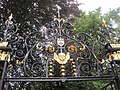 | Ruthin Churchyard Ornamental Wrought Iron Gates & Screen | Gate | Ruthin | 53°06′54″N3°18′39″W / 53.1151°N 3.3108°W , SJ124583 | Denbighshire | Post-Medieval/Modern | DE159 [168] | |
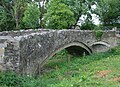 | Pont Dafydd (old) | Bridge | St Asaph | 53°15′49″N3°26′06″W / 53.2636°N 3.4349°W , SJ043750 | Flintshire | Post-Medieval/Modern | FL027 [169] | |
 | St Asaph Bridge | Bridge | St Asaph | 53°15′23″N3°26′51″W / 53.2564°N 3.4476°W , SJ035742 | Flintshire | Post-Medieval/Modern | FL026 [170] | |
| Pennant Mines Winding Engine House & Chimney, Rhuallt | Engine house | Tremeirchion | 53°16′02″N3°22′10″W / 53.2673°N 3.3694°W , SJ087753 | Flintshire | Post-Medieval/Modern | FL137 [171] | ||
 | First World War Practice Trenches at Bodelwyddan Park | Practice trenches | Bodelwyddan | 53°15′28″N3°30′00″W / 53.2577°N 3.4999°W , SJ000744 | Flintshire | Post-Medieval/Modern | FL186 [172] | |


Scheduled monuments in Denbighshire, Wales.
 =Prehistoric
  =Roman
  =Early Medieval
 =Medieval
  =Post-Medieval/Modern
