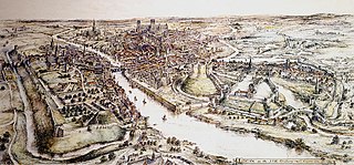
A motte-and-bailey castle is a European fortification with a wooden or stone keep situated on a raised area of ground called a motte, accompanied by a walled courtyard, or bailey, surrounded by a protective ditch and palisade. Relatively easy to build with unskilled labour, but still militarily formidable, these castles were built across northern Europe from the 10th century onwards, spreading from Normandy and Anjou in France, into the Holy Roman Empire in the 11th century. The Normans introduced the design into England and Wales. Motte-and-bailey castles were adopted in Scotland, Ireland, the Low Countries and Denmark in the 12th and 13th centuries. Windsor Castle, in England, is an example of a motte-and-bailey castle. By the end of the 13th century, the design was largely superseded by alternative forms of fortification, but the earthworks remain a prominent feature in many countries.

Prestatyn is a seaside town and community in Denbighshire, Wales. Historically a part of Flintshire, it is located on the Irish Sea coast, to the east of Rhyl. At the 2001 Census, Prestatyn had a population of 18,496, that increased to 18,849 at the 2011 census.

Melling-with-Wrayton is a civil parish in the City of Lancaster in the English county of Lancashire. It includes the village of Melling and the hamlet of Wrayton, to the northeast. The parish had a population of 290 recorded in the 2001 census, increasing slightly to 299 at the 2011 census.

Wormegay Castle is a motte and bailey earthwork, located next to the village of Wormegay in the English county of Norfolk.

Wallingford Castle was a major medieval castle situated in Wallingford in the English county of Oxfordshire, adjacent to the River Thames. Established in the 11th century as a motte-and-bailey design within an Anglo-Saxon burgh, it grew to become what historian Nicholas Brooks has described as "one of the most powerful royal castles of the 12th and 13th centuries". Held for the Empress Matilda during the civil war years of the Anarchy, it survived multiple sieges and was never taken. Over the next two centuries it became a luxurious castle, used by royalty and their immediate family. After being abandoned as a royal residence by Henry VIII, the castle fell into decline. Refortified during the English Civil War, it was eventually slighted, i.e. deliberately destroyed, after being captured by Parliamentary forces after a long siege. The site was subsequently left relatively undeveloped, and the limited remains of the castle walls and the considerable earthworks are now open to the public.

Skipsea Castle was a Norman motte and bailey castle near the village of Skipsea, East Riding of Yorkshire, England. Built around 1086 by Drogo de la Beuvrière, apparently on the remains of an Iron Age mound, it was designed to secure the newly conquered region, defend against any potential Danish invasion and control the trade route across the region leading to the North Sea. The motte and the bailey were separated by Skipsea Mere, an artificial lake that was linked to the sea during the medieval period via a navigable channel. The village of Skipsea grew up beside the castle church, and the fortified town of Skipsea Brough was built alongside the castle around 1160 to capitalise on the potential trade.

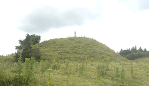
Twthill is a Norman castle located near the town of Rhuddlan, Denbighshire in Wales; historic names for the site include Toothill and Tot Hill Castle and it is also known as Old Rhuddlan Castle. It is a motte-and-bailey castle and was later replaced by the much larger, stone-built Rhuddlan Castle. The only remaining visible signs of the old castle are the large mound of the motte, and traces of the wall that surrounded the bailey.
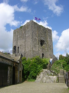
Clitheroe Castle is a ruined early medieval castle in Clitheroe in Lancashire, England. It was the caput of the Honour of Clitheroe, a vast estate stretching along the western side of the Pennines.

Burton in Lonsdale Castle was in the village of Burton in Lonsdale in North Yorkshire, England.
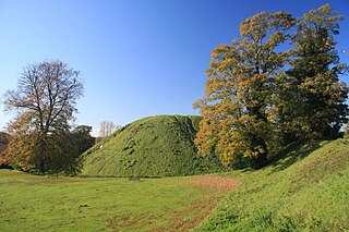
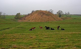
Thetford Castle is a medieval motte and bailey castle in the market town of Thetford in the Breckland area of Norfolk, England. The first castle in Thetford, a probable 11th-century Norman ringwork called Red Castle, was replaced in the 12th century by a much larger motte and bailey castle on the other side of the town. This new castle was largely destroyed in 1173 by Henry II, although the huge motte, the second largest man-made mound in England, remained intact. The motte, recognised as a scheduled monument, now forms part of a local park, and the remains are known variously as Castle Hill, Castle Mound and Military Parade.
Watch Hill Castle is a medieval motte-and-bailey on the boundary of Bowdon and Dunham Massey, Greater Manchester, England. It is a scheduled monument. The castle is located north of the River Bollin and south of a deep ravine.
Stockport Castle was a promontory castle in Stockport, Cheshire. The castle was in the medieval town, overlooking a ford over the River Mersey. It was first documented in 1173, but the next mention of it is in 1535 when it was in ruins. What remained of the castle was demolished in 1775.

Mold Castle, also known as Bailey Hill in the town of Mold, Flintshire, north-east Wales, is a motte-and-bailey castle erected around 1072, probably by the Norman Robert de Montalt under instructions from Hugh d'Avranches, Earl of Chester. Little remains except the mound on which the motte was built. It stands close to the 15th-century parish church, St Mary's Church near the centre of the town.
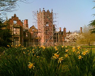
Bank Hall is a Jacobean mansion in Bretherton, Lancashire, England. It is a Grade II* listed building and is at the centre of a private estate, surrounded by parkland. The hall was built on the site of an older house in 1608 by the Banastres who were lords of the manor. The hall was extended during the 18th and 19th centuries. Extensions were built for George Anthony Legh Keck in 1832–1833, to the design of the architect George Webster.
Buddugre Castle was a motte and bailey defensive fortification overlooking the River Ithon, located in the community of Llanddewi Ystradenny, in Radnorshire, Wales. It is believed to have been built as a defensive measure in the medieval period, during the 12th century, as a timber castle.

Berkhamsted Castle is a Norman motte-and-bailey castle in Berkhamsted, Hertfordshire. The castle was built to obtain control of a key route between London and the Midlands during the Norman conquest of England in the 11th century. Robert of Mortain, William the Conqueror's half brother, was probably responsible for managing its construction, after which he became the castle's owner. The castle was surrounded by protective earthworks and a deer park for hunting. The castle became a new administrative centre of the former Anglo-Saxon settlement of Berkhamsted. Subsequent kings granted the castle to their chancellors. The castle was substantially expanded in the mid-12th century, probably by Thomas Becket.
Bishopton Castle was a medieval castle in Bishopton village, County Durham, England. The surviving motte is a Scheduled Ancient Monument.
Granard Motte is the remains of a motte-and-bailey castle and National Monument in Granard, County Longford, Ireland.
