Moel y Gaer, Llantysilio

Last updated

Moel y Gaer
Moel y Gaer, Llantysilio.jpg
Moel y Gaer, Llantysilio
Typehillfort
Location Denbighshire, Wales
Coordinates 53°00′29″N3°14′34″W / 53.0081°N 3.2428°W / 53.0081; -3.2428 Coordinates: 53°00′29″N3°14′34″W / 53.0081°N 3.2428°W / 53.0081; -3.2428
OS grid reference SJ 16705 46365
Elevation504 metres (1,654 ft)
Official nameMoel y Gaer, Cefn
Reference no.DE126
Community Bryneglwys
Denbighshire UK relief location map.jpg
Red pog.svg
Location in Denbighshire

Moel y Gaer (Welsh for "bald hill of the fortress") is an Iron Age hillfort on a summit of Llantysilio Mountain, northwest of the town of Llangollen, Denbighshire, Wales. The site is a scheduled monument classified as a prehistoric defensive hillfort. [1]

Contents

The hillfort is also protected and managed as part of the Heather and Hillforts Project. The project includes six hillforts: the four most southerly of the hillforts in the Clwydian Range (Penycloddiau, Moel Arthur, Moel y Gaer Llanbedr, and Moel Fenlli), this hillfort and Caer Drewyn. [2]

Description

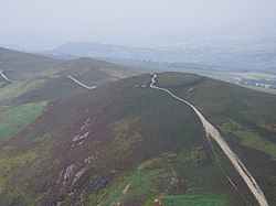
The defensive works at Moel y Gaer comprise a roughly oval area measuring about 140 metres (460 ft) east-west by 100 metres (330 ft), enclosing approximately 0.95 hectares (2.3 acres), and consist of a single rampart and a discontinuous ditch, with a single entrance on the eastern side. [3] [4] [5] The stone bank is up to 3.1 metres (10 ft) high externally and 0.6 metres (2.0 ft) internally, and the ditch to the north is 10 metres (33 ft) wide. The summit reaches 503.5 metres (1,652 ft) above sea level. [6] A track crossing the site from east to west, used by pedestrians and drivers of off-road vehicles, presents a threat to the archaeological remains. [7]

Excavations and surveys

As part of the Heather and Hillforts Project a topographic survey was commissioned, which took place between December 2006 and January 2007. The survey recorded the remains of 11 roundhouse platforms within the enclosure, concentrated on the eastern side. [7] A geophysical survey followed in 2009, which identified more possible roundhouses, along with possible internal tracks and two potential rectangular structures. [8]

In 2010 an archaeological excavation identified two roundhouses of about 7 metres (23 ft) diameter from different periods of occupation, and the results showed preservation of significant archaeological deposits in the interior of the hillfort, but also the fragile nature of the resource. [9]

See also

Related Research Articles

Clwydian Range Hill range in Wales

The Clwydian Range is a series of hills in the north-east of Wales that runs from Llandegla in the south to Prestatyn in the north, with the highest point being the popular Moel Famau. The range forms part of the Clwydian Range and Dee Valley Area of Outstanding Natural Beauty.

Denbigh Moors

Denbigh Moors is an upland region in Conwy and Denbighshire in north-east Wales, between Snowdonia and the Clwydian Range. It includes the large reservoirs Llyn Brenig and Llyn Alwen, and the Clocaenog Forest, which has one of Wales's last populations of red squirrels. It also contains the open heath Hafod Elwy Moor National Nature Reserve.

Clwyd-Powys Archaeological Trust

The Clwyd-Powys Archaeological Trust(CPAT) (Welsh: Ymddiriedolaeth Archeolegol Clwyd-Powys is an educational charity which was established in 1975. Its objective is ‘to advance the education of the public in archaeology’. CPAT is one of four Welsh Archaeological Trusts which work to help protect, record and interpret all aspects of the historic environment. This includes providing advice to local authorities on archaeology and planning, undertaking archaeological projects for private- and public-sector clients, and delivering a programme of community archaeology events and activities.

Moel y Gaer, Rhosesmor

Moel y Gaer is an Iron Age hillfort located on a summit at the southern end of Halkyn Mountain, overlooking the village of Rhosesmor, Flintshire, Wales. It is a well-preserved hillfort overlooking the Dee Estuary. Excavations in the early 1970s revealed a sequence of defensive structures made of timber and several phases of building work inside the ramparts.

Moel y Gaer may refer to any of several prehistoric hillforts in Wales:

Moel y Gaer, Bodfari Iron Age hillfort in Denbighshire, Wales

Moel y Gaer is an Iron Age hillfort at the northern end of the Clwydian Range, located on a summit overlooking the valley of the River Wheeler, near the village of Bodfari, Denbighshire, Wales, five miles north-east of Denbigh. The site is a scheduled monument, classified as a prehistoric defensive hillfort.

Moel y Gaer, Llanbedr Iron Age hillfort in Denbighshire, Wales

Moel y Gaer, also known as Moel-y-Gaer Camp or Moel y Gaer Hillfort, is an Iron Age hillfort located on a western spur of the Clwydian Range, near the village of Llanbedr, Denbighshire, Wales. The site is a scheduled monument, classified as a prehistoric defensive hillfort.

Moel y Gamelin

Moel y Gamelin is a hill in Denbighshire, North Wales, to the northwest of the town of Llangollen. It is the highest summit of a range which stretches eastwards from near the village of Carrog to the Horseshoe Pass traversed by the A542 road, and reaches an elevation of 577 metres (1,893 ft) above sea level. The western part of the range is known as Llantysilio Mountain whilst the eastern end is referred to as Maesyrchen Mountain. At its top is a round cairn, of unknown date, measuring about 30 metres (100 ft) in diameter and 1.8 metres (6 ft) high. It is in the Clwydian Range and Dee Valley Area of Outstanding Natural Beauty.

Burfa Castle

Burfa Castle is an Iron Age hillfort near the tiny town of Old Radnor, Radnorshire in Powys, Wales. The site is a scheduled monument described as a prehistoric defensive hillfort, and was included in an inventory of monuments by 1913. The site is near Offa's Dyke which passes near the bottom of Burfa Bank.

Ffynnon Beuno and Cae Gwyn Caves

Ffynnon Beuno and Cae Gwyn Caves are two Scheduled Ancient Monuments, in Denbighshire, Wales, which are also designated a Site of Special Scientific Interest (SSSI).

Maen Huail

Maen Huail is a stone block at St Peter's Square, in the centre of Ruthin, Denbighshire, North Wales. A circular plaque next to it states "Maen Huail on which tradition states, King Arthur beheaded Huail, brother of Gildas the historian". The stone was recorded in 1699 as being in the middle of the road, and now stands on a concrete plinth against the half-timbered wall of the Barclays Bank building, a 20th-century copy of the now mainly destroyed Exmewe Hall.

Cefn Caves are a group of four interlinked caves in the limestone cliffs of the Elwy valley, north of Denbigh, in Denbighshire, North Wales. Early excavations found both human and animal remains dating back to the Paleolithic period. The cave network is a Scheduled Ancient Monument.

Bedd-y-Cawr Hillfort Iron age hillfort in North Wales

Bedd-y-Cawr Hillfort, or Bedd y Cawr Hillfort, is an Iron Age hillfort on a natural inland promontory in the community of Cefnmeiriadog in Denbighshire in North Wales. The name of the hillfort translates from the Welsh as Giant's Tomb.

Moel Arthur

Moel Arthur is an Iron Age hillfort in Flintshire, Wales, at the boundary with Denbighshire, about 5 miles (8.0 km) east of Denbigh [Grid reference SJ 14529 66034].

Clwydian Range and Dee Valley Area of Outstanding Natural Beauty in Wales

The Clwydian Range and Dee Valley is a designated Area of Outstanding Natural Beauty (AONB) and proposed national park, located in north-east Wales, covering the Clwydian Range, and the valley of the River Dee. Designated in 1985 as the Clwydian Range AONB, and expanded to its current form in 2011, the Area of Outstanding Natural Beauty includes: medieval field systems, open heather moorland, prehistoric hillforts, limestone crags, broad leaved woodland, wooded valleys, and farmland. In 2018, an estimated 1.1 million people visited six key sites across the AONB, generating approximately £24.1 million to the Welsh economy, according to Natural Resources Wales. The AONB falls within the jurisdiction of the local authorities of Denbighshire, Flintshire, and Wrexham County Borough, with the majority, 80% of the AONB in Denbighshire, and the remaining 20% split evenly between the other two authorities. The AONB is the largest of only five AONBs in Wales, and one of the 46 in the United Kingdom. Additionally, it is one of only 8 protected areas of Wales. Long-distance footpaths; Offa's Dyke Path, and the Clwydian Way pass through the AONB. The area of the Clwydian Range and Dee Valley AONB is 390 km2 (150 sq mi), and has been proposed by the Welsh Government to become Wales' fourth national park.

References

  1. Moel y Gaer, Cefn. National Monuments Record of Wales (NMRW) (Report). Cadw. Cadw Id: DE126.
  2. "Submission to the UK Landscape Award 2010: Discovering Great Places" (PDF). Heather and Hillforts Partnership Board. August 2010. p. 3. Retrieved 25 April 2016.
  3. Driver, T. (17 May 2010) [2008]. "Moel-y-Gaer, Hillfort, Llantysilio". National Monuments Record of Wales (NMRW). Royal Commission on the Ancient and Historical Monuments of Wales (RCAHMW). NPRN 306813. Retrieved 25 April 2016 via coflein (online database of the NMRW).{{cite web}}: External link in |via= (help)
  4. Brooks, I.P.; Laws, K. (January 2007). Heather and Hillforts Survey Report: Moel y Gaer, Lantysilio (PDF) (Report). Engineering Archaeological Services. p. 2. EAS Survey Report 2007/01. Retrieved 25 April 2016.
  5. "Moel y Gaer Llantysilio". Heather and Hillforts: The Clwydian Hillforts Condition Survey. Clwyd-Powys Archaeological Trust (CPAT) . Retrieved 25 April 2016.
  6. "Moel y Gaer". Hill Bagging. Retrieved 25 April 2016.
  7. 1 2 Brooks & Laws 2007, p. 3.
  8. Grant, I. (November 2010). "Moel y Gaer Hillfort, Llantysilio, Denbighshire: Archaeological Excavation" (PDF). Clwyd-Powys Archaeological Trust (CPAT). p. 3. CPAT Report No 1059. Retrieved 25 April 2016.
  9. Grant 2010, p. 2.
  10. "Moel y Gaer Llantysilio Hillfort". Historic Environment Record (HER) . Glamorgan-Gwent Archaeological Trust (GGAT). PRN 101366. Retrieved 25 April 2016 via archwilio (online database of the four Welsh Archaeological Trusts).{{cite web}}: External link in |via= (help)