Efenechtyd

Last updated

Efenechtyd
Sant Mihangel a'r Holl Angylion, Efenechtyd, Sir Ddinbych 01.JPG
St Michael and All Angels
Denbighshire UK location map.svg
Red pog.svg
Efenechtyd
Location within Denbighshire
Population655 (2011) [1]
OS grid reference SJ115555
Community
  • Efenechtyd
Principal area
Country Wales
Sovereign state United Kingdom
Post town RUTHIN
Postcode district LL15
Dialling code 01824
Police North Wales
Fire North Wales
Ambulance Welsh
UK Parliament
Senedd Cymru – Welsh Parliament
List of places
UK
Wales
Denbighshire
53°05′28″N3°19′41″W / 53.091°N 3.328°W / 53.091; -3.328 Coordinates: 53°05′28″N3°19′41″W / 53.091°N 3.328°W / 53.091; -3.328

Efenechtyd (Welsh : Efenechdyd) is a hamlet and community in a deep valley in Denbighshire, Wales which contains the Church of St Michael and All Angels. Efenechtyd is also the name of an electoral ward. the community includes the village of Pwllglas.

Contents

Governance

The Efenechtyd electoral ward elects a county councillor to site on Denbighshire County Council. [2] This ward stretches to the south-west of Efenechtyd with a total population taken at the 2011 census of 1,686, [3] the community population being 655.

Church of St Michael and All Angels

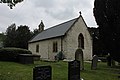
St Michael's is the tiny church of Efenechtyd. At twenty feet wide, St Michael's is the second smallest church in the diocese of St Asaph. [4]

The circular churchyard suggests Celtic origins. The church may have been founded by monks from St Saeran's at Llanynys and probably dates from the 13th century. The east window probably dates from c. 1400. [4]

The church's most notable feature is its rare medieval wooden font, probably of 15th or 16th-century origin, similar to the stone fonts fashionable at that time. It is made from a single circular oak block with fourteen facets over a ring of beading. Similarly the battlemented rail near the altar is also late medieval and part of a rood screen. [4] Another notable feature includes a fragment of a Welsh wall-painted Ten Commandments, probably Elizabethan or Jacobean. Monuments include a painted timber memorial to Catherine Lloyd (1810) and a Georgian monument to Joseph Conway of Plas-yn-Llan, near the churchyard gate. [4]

The church was extensively restored in 1873.

The rounded stone by the font is the ‘Maen Camp’, formerly used at the local ‘campau’ (‘Sports’) on St. Michael's Day, 29 September. Village Samsons strove to hurl it backwards over their heads. [5]

The custom of throwing the Feat Stone has been revived in recent years and takes place at the Harvest Festival celebrations. [6]

Related Research Articles

Cilgerran Human settlement in Wales

Cilgerran is both a village, a parish, and also a community, situated on the south bank of the River Teifi in Pembrokeshire, Wales. It was formerly an incorporated market town.

Meifod Human settlement in Wales

Meifod, formerly also written Meivod, is a small village, community and electoral ward 7 miles north-west of Welshpool in Montgomeryshire, Powys, Wales, on the A495 road and located in the valley of the River Vyrnwy. The River Banwy has a confluence with the Vyrnwy approximately two miles to the west of the village. The village itself had a population of 317. The community includes the village of Bwlch-y-cibau and the hamlet of Allt-y-Main.

Llanystumdwy Human settlement in Wales

Llanystumdwy[ɬanɪstɪmdʊɨ] is a predominantly Welsh-speaking village, community and electoral ward on the Llŷn Peninsula of Gwynedd in Wales. It is not regarded as being part of Llŷn, but as belonging instead to the ancient commote of Eifionydd on the Cardigan Bay coast, where it has its own beach. The community includes the villages of Chwilog, Afon Wen, Llanarmon, and Llangybi, plus the hamlets of Rhoslan and Pencaenewydd.

Llandinam Human settlement in Wales

Llandinam is a village and community in Montgomeryshire, Powys, central Wales, between Newtown and Llanidloes, located on the A470. As a community, Llandinam is made up of the village itself, small hamlets including Plas Dinam and Little London and several farms. The village itself has a population of around 576 with 56% born in Wales.

Penbryn Human settlement in Wales

Penbryn is a small coastal village and community in Ceredigion, Wales, about 8 miles (13 km) from Cardigan.

Church Stoke Human settlement in Wales

Churchstoke or Church Stoke is a village, community and electoral ward in Montgomeryshire, Powys, Wales. Located in the southeast of the Vale of Montgomery, it is overlooked by Todleth Hill, Roundton Hill and Corndon Hill. The rivers Caebitra and Camlad have their confluence just outside the village. The nearest town is Montgomery. In the 2011 census the village had a population of 708.

Clynnog Fawr Human settlement in Wales

Clynnog Fawr, often simply called "Clynnog", is a village and community on the north coast of the Llŷn Peninsula in Gwynedd, north-west Wales. It is in the historic county of Caernarfonshire. The community includes Pant Glas.

St Peters Church, Aston-by-Sutton Church in Cheshire , England

St Peter's Church is in the small hamlet of Aston-by-Sutton, Cheshire near to the town of Runcorn. The church is recorded in the National Heritage List for England as a designated Grade I listed building. It is an active Anglican parish church in the diocese of Chester, the archdeaconry of Chester and the deanery of Great Budworth. It is one of three parish churches in the parish of Aston-by-Sutton, Little Leigh and Lower Whitley. The other two being St Michael and All Angels, Little Leigh and St Luke, Lower Whitley. The three were previously individual parishes united in a benefice along with St Mark, Antrobus. The listing describes it as "a most pleasing late 17th to early 18th-century church, inside and out". The church stands in a relatively isolated position in the south side of Aston Lane in the hamlet.

Llanfair Dyffryn Clwyd Human settlement in Wales

Llanfair Dyffryn Clwyd is a village and community in Denbighshire, Wales, situated in the Vale of Clwyd about one mile south of the town of Ruthin. By the 2001 census, it had 1048 residents and 50.6% of them could speak Welsh. The figures for the 2011 census were: population 1,053:Welsh speakers 46.9%. The age group with the highest percentage of Welsh speakers was the 15-year-olds where every one could speak it. The villages of Pentrecelyn and Graig Fechan are located in the community.

Pennard Human settlement in Wales

Pennard is a village and community on the south of the Gower Peninsula, about 7 miles south-west of Swansea city centre. It falls within the Pennard electoral ward of Swansea. The Pennard community includes the larger settlements of Southgate and Kittle. the population as of 2011 was 2,688.

Bryngwran Human settlement in Wales

Bryngwran is a village and community in the Welsh county of Anglesey, located on the A5 London to Holyhead trunk road. It lies 8.1 miles (13.0 km) west of Llangefni, 7.0 miles (11.3 km) south west of Llannerch-y-medd and 7.4 miles (11.9 km) south east of Holyhead, and includes the villages of Bryngwran, Capel Gwyn and Engedi. At the 2001 census the community had a population of 781, increasing to 894 at the 2011 election. The village itself has a population of around 400.

St Pabos Church, Llanbabo Church in Wales

St Pabo's Church, Llanbabo is a medieval church in Llanbabo, in Anglesey, North Wales. Much of the church dates to the 12th century, and it is regarded as a good example of a church of its period that has retained many aspects of its original fabric. The church houses a tombstone slab from the 14th century, depicting a king with crown and sceptre, bearing the name of Pabo Post Prydain, the reputed founder of the church. However, there is no evidence that Pabo, a 5th-century prince, lived in the area and the tradition that he founded the church has little supporting basis.

St Caffos Church, Llangaffo Church in Wales

St Caffo's Church, Llangaffo is a 19th-century church, in the south of Anglesey, north Wales, about 5 miles (8.0 km) from the county town, Llangefni. It was constructed in 1846 to replace the previous medieval church in the village of Llangaffo. The new building includes a number of monuments from the old church, and has a spire which is a prominent local landmark. The churchyard has part of a stone cross dating from the 9th or 10th century, and some gravestones from the 9th to 11th centuries. It is dedicated to St Caffo, a 6th-century martyr who was killed in the vicinity.

Llanfwrog, Denbighshire Human settlement in Wales

Llanfwrog is a village in Denbighshire, in northern Wales. It hosts a church, Llanfwrog Church of St Mwrog and St Mary. The sturdy medieval tower of St Mwrog's crowns the hill west of Ruthin, marking the point where town gives way to countryside. ‘Double-naved’ in the distinctive Clwydian style, the church is late medieval, but was much altered by Victorian restoration. The church was again restored in 1999. There are fine views from the circular ‘Celtic’ churchyard – St Mwrog was a little known Welsh saint, perhaps from Anglesey. On a rise to the south by the road to Efenechtyd stands an ancient thatched and whitewashed house (private).

St Marys Church, Llanfair-yn-y-Cwmwd Church in Wales

St Mary's Church, Llanfair-yn-y-Cwmwd is a small medieval parish church near the village of Dwyran, in Anglesey, north Wales. The building probably dates from the 15th century, with some alterations. It contains a 12th-century carved stone font and a 13th-century decorated coffin lid. The bell is inscribed with the year of its casting, 1582. The historian Henry Rowlands was vicar of St Mary's in the late 17th and early 18th centuries. Maurice Wilks, who invented the Land Rover, is buried in the churchyard.

Flemingston Human settlement in Wales

Flemingston is a small village in the Vale of Glamorgan in south Wales. It is located 8.5 miles (13.7 km) northwest by road from the town centre of Barry. It contains the Church of St. Michael the Archangel, the ruins of Flemingston Court, and Flemingston Manor or Grange, all of which are listed buildings. Historically, the parish of Flemingston was a sub-manor of Aberthaw or St Athan.

St Marys Church, Acton Burnell Church in Shropshire, England

St Mary's Church is in the village of Acton Burnell, Shropshire, England, and stands near the ruins of Acton Burnell Castle. It is an active Anglican parish church in the deanery of Condover, the archdeaconry of Ludlow, and the diocese of Hereford. Its benefice is united with those of St Andrew and St Mary, Condover, St Mark, Frodesley, and St Michael and All Angels, Pitchford. The church is recorded in the National Heritage List for England as a designated Grade I listed building.

Llanddyfnan Human settlement in Wales

Llanddyfnan is a village and community in the Welsh county of Anglesey, located 3.5 miles (5.6 km) north east of Llangefni, 6.6 miles (10.6 km) north west of Menai Bridge and 7.1 miles (11.4 km) west of Beaumaris.

Clocaenog Human settlement in Wales

Clocaenog is a village and community in Denbighshire, north-east Wales. It lies on the outskirts of Ruthin and the Clocaenog Forest. The forest near the village has many walks of varying length and is one of the venues for the Wales Rally GB.

References

  1. "Community Population 2011" . Retrieved 23 May 2015.
  2. Gareth Joy (5 May 2017) Election 2017: Denbighshire Council results, Point FM . Retrieved 29 March 2018.
  3. "Ward population 2011" . Retrieved 23 May 2015.
  4. 1 2 3 4 Site 4 - Efenechtyd - Church of St Michael and All Angels, Medieval-Wales.com. Retrieved 29 March 2018.
  5. Dr Charles Kightly. Enjoy Medieval Denbighshire. Denbighshire County Council.
  6. |accessdate=2013-11-31], Maen Camp 2013

Living Paths

As of 28 April 2011, this article is derived in whole or in part from medieval-wales.com/index.php. The copyright holder has licensed the content in a manner that permits reuse under CC BY-SA 3.0 and GFDL. All relevant terms must be followed.The original text was at "Efenechtyd"