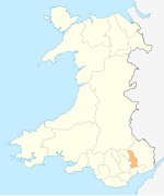
Scheduled monuments in Torfaen
| Image | Name | Site type | Community | Location | Details | Period | SAM No & Refs |
|---|---|---|---|---|---|---|---|
| Carn-y-Defaid Round Cairns | Round cairn | Blaenavon, (also Llanfoist Fawr), (see also Monmouthshire) | 51°47′03″N3°03′31″W / 51.7842°N 3.0585°W , SO270100 | Prehistoric | MM209 [4] | ||
| Cairns (4) West of Craig y Dyffryn | Round cairn | Henllys | 51°37′43″N3°05′01″W / 51.6285°N 3.0835°W , ST251927 | Prehistoric | MM045 [5] | ||
| Capel Newydd, Blaenavon (site of) | Chapel | Blaenavon | 51°45′47″N3°03′33″W / 51.763°N 3.0592°W , SO269076 | Medieval | MM212 [6] | ||
| Llanderfel Church | Church | Fairwater | 51°39′06″N3°03′55″W / 51.6516°N 3.0653°W , ST263953 | Medieval | MM271 [7] | ||
 | St. Peter's Churchyard Cross, Henllys | Cross | Henllys | 51°36′48″N3°03′32″W / 51.6132°N 3.059°W , ST267910 | Medieval | MM309 [8] | |
| Llantarnam Churchyard Cross | Cross | Llantarnam | 51°37′58″N3°00′10″W / 51.6328°N 3.0028°W , ST306931 | Socket and shaft of a medieval cross, with modern steps and cross-head. | Medieval | MM136 [9] | |
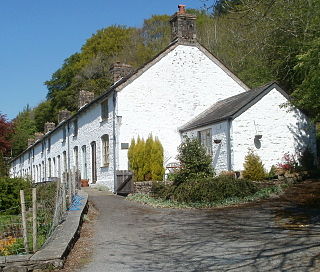
| Llantarnam Abbey Tithe Barn | Tithe barn | Llantarnam | 51°37′54″N2°59′43″W / 51.6317°N 2.9954°W , ST312930 | Long presumed to be an abbey building, this is now thought to be a 17th-century building | Medieval | MM137 [10] | |
 | Abersychan Limestone Railway | Railway | Abersychan | 51°43′57″N3°03′07″W / 51.7324°N 3.0519°W , SO274042 | Built c 1830 to carry limestone from Cwm Lascarn quarry to the British Ironworks. | Post Medieval/Modern | GM597 [11] |
| Air Furnace at British Ironworks | Ironworks | Abersychan | 51°43′34″N3°04′37″W / 51.7262°N 3.0769°W , SO257036 | Rare remains of a reverbatory air furnace used for re-melting cast iron. The furnace is in the courtyard of the derelict foundry buildings. | Post-Medieval/Modern | MM221 [12] | |
 | British Colliery Pumping Engine House | Engine house | Abersychan | 51°43′36″N3°04′30″W / 51.7266°N 3.0751°W , SO258036 | Cornish beam pumping engine house built by the British Iron Company. Built of sandstone with a slate roof, and retains several fixtures. | Post-Medieval/Modern | MM216 [13] |
 | Cwmbyrgwm Colliery | Coal Mine | Abersychan | 51°43′25″N3°05′09″W / 51.7236°N 3.0858°W , SO252033 | Site of former colliery including remains of a water-balance headgear, chimney, oval shafts, water power dams, tramroad routes, and waste tips. | Post-Medieval/Modern | MM163 [14] |
| Aaron Brute's Level and Iron Bridge | Level | Blaenavon | 51°46′22″N3°05′27″W / 51.7728°N 3.0909°W , SO248088 | Post-Medieval/Modern | MM220 [15] | ||
 | Blaenavon Ironworks | Industrial monument | Blaenavon | 51°46′37″N3°05′21″W / 51.777°N 3.0892°W , SO249092 | Post-Medieval/Modern | MM200 [16] | |
| Blaenavon Upper Brick Yard | Quarry | Blaenavon | 51°46′52″N3°05′13″W / 51.781°N 3.087°W , SO251097 | Also known as Bunker Hill Brick Yard. | Post-Medieval/Modern | MM296 [17] | |
| Brake Engine on Hill Pits Tramroad Incline | Industrial monument | Blaenavon | 51°46′57″N3°05′56″W / 51.7826°N 3.099°W , SO242098 | Post-Medieval/Modern | MM222 [18] | ||
| Coal and Iron Ore Workings West of Abergavenny Road, Blaenavon | Iron mine | Blaenavon | 51°47′13″N3°05′02″W / 51.7869°N 3.084°W , SO253103 | Post-Medieval/Modern | MM297 [19] | ||
| Coity Sandstone Quarry and Incline | Quarry | Blaenavon | 51°46′12″N3°06′37″W / 51.7699°N 3.1102°W , SO234084 | Post-Medieval/Modern | MM279 [20] | ||
 | Dyne Steel Incline | Incline | Blaenavon, (also Llanfoist Fawr), (see also Monmouthshire) | 51°47′36″N3°06′06″W / 51.7933°N 3.1017°W , SO241110 | Post-Medieval/Modern | MM280 [21] | |
| Engine Pit, Blaenavon | Coal Mine | Blaenavon | 51°46′29″N3°05′50″W / 51.7747°N 3.0972°W , SO243090 | Earliest Blaenafon shaft coalmine, sunk in 1806 | Post-Medieval/Modern | MM277 [22] | |
 | Iron and coal patching at Pen-ffordd-goch (Keeper's Pond), Blaenavon | Industrial monument | Blaenavon, (also Llanfoist Fawr), (see also Monmouthshire) | 51°47′18″N3°04′38″W / 51.7882°N 3.0773°W , SO257104 | Post-Medieval/Modern | MM227 [23] | |
| Ironstone Quarries at Carreg Maen Taro | Quarry | Blaenavon, (also Llanfoist Fawr and Llanelly), (see also Monmouthshire) | 51°47′38″N3°06′20″W / 51.794°N 3.1056°W , SO238111 | Post-Medieval/Modern | MM295 [24] | ||
| Old Coal Pits, Blaenavon | Air Shaft | Blaenavon | 51°46′46″N3°05′51″W / 51.7795°N 3.0974°W , SO243095 | Post-Medieval/Modern | MM293 [25] | ||
 | Pwll Du Tramroad Tunnel Southern Approach | Industrial monument | Blaenavon | 51°46′53″N3°05′26″W / 51.7814°N 3.0905°W , SO248096 | Post-Medieval/Modern | MM223 [26] | |
| Iron Ore Scours at Upper Race, Pontypool | Industrial monument | Pontymoile | 51°40′53″N3°02′55″W / 51.6815°N 3.0486°W , ST276986 | Post-Medieval/Modern | MM256 [27] | ||
| Old Beam Pump & Winding Engine, Glyn Pits | Industrial building | Pontymoile | 51°41′33″N3°03′50″W / 51.6924°N 3.0638°W , ST265998 | Post-Medieval/Modern | MM192 [28] | ||


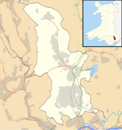
Scheduled Monuments in Torfaen, Wales.
 =Prehistoric
  =Roman
  =Early Medieval
 =Medieval
  =Post-Medieval/Modern