Llantarnam

Last updated

Llantarnam
  • Welsh: Llanfihangel Llantarnam
The Greenhouse, Llantarnam - geograph.org.uk - 1639590.jpg
The Greenhouse
Torfaen UK location map.svg
Red pog.svg
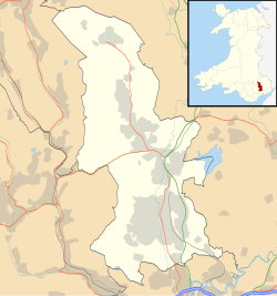
Llantarnam
Location within Torfaen
Area6.56 km2 (2.53 sq mi)  [1]
Population4,125 (2011) [2]
  Density 629/km2 (1,630/sq mi)
OS grid reference ST 305 935
Community
  • Llantarnam
Principal area
Preserved county
Country Wales
Sovereign state United Kingdom
Post town CWMBRAN
Postcode district NP44
Dialling code 01633
Police Gwent
Fire South Wales
Ambulance Welsh
UK Parliament
Senedd Cymru – Welsh Parliament
List of places
UK
Wales
Torfaen
51°38′10″N3°00′20″W / 51.63599°N 3.00563°W / 51.63599; -3.00563

Llantarnam (Welsh : Llanfihangel Llantarnam) is a village of Cwmbran, and is a community and electoral ward in the county borough of Torfaen in south east Wales. The ward covers the same area as the community, but also includes Southville. It is equidistant from Cwmbran town centre and the town of Caerleon.

Contents

Llantarnam Abbey is a Cistercian abbey founded in 1179 as a daughter house of Strata Florida Abbey. The remains of that abbey are incorporated into the present buildings housing the Sisters of Saint Joseph. It also contains St Michael's Church.

Llantarnam Hall is home to Rougemont School.

In 2015 Llantarnam School amalgamated with Fairwater High School to make the new school of Cwmbran High School.

Demographics

At the 2011 Census

Notable people

See also

Related Research Articles

<span class="mw-page-title-main">Abersychan</span> Town in Wales

Abersychan is a town and community north of Pontypool in Torfaen, Wales, and lies within the boundaries of the historic county of Monmouthshire and the preserved county of Gwent.

<span class="mw-page-title-main">Cwmbran</span> Human settlement in Wales

Cwmbran is a town in the county borough of Torfaen in South Wales.

<span class="mw-page-title-main">Torfaen</span> County borough in Wales

Torfaen is a county borough in the south-east of Wales. Torfaen is bordered by the county of Monmouthshire to the east, the city of Newport to the south, and the county boroughs of Caerphilly and Blaenau Gwent to the south-west and north-west. It is within the boundaries of the historic county of Monmouthshire, and between 1974 and 1996 was a district of Gwent, until it was reconstituted as a principal area in 1996.

<span class="mw-page-title-main">Blaenavon</span> Human settlement in Wales

Blaenavon is a town and community in Torfaen county borough, Wales, high on a hillside on the source of the Afon Lwyd. It is within the boundaries of the historic county of Monmouthshire and the preserved county of Gwent. The population is 6,055.

<span class="mw-page-title-main">Croesyceiliog</span> Human settlement in Wales

Croesyceiliog is a suburb of Cwmbran, Wales.

<span class="mw-page-title-main">New Inn</span> Human settlement in Wales

New Inn - - is a village and community directly south east of Pontypool, within the County Borough of Torfaen in Wales, within the historic boundaries of Monmouthshire. It had a population of 5,986 at the 2011 Census.

<span class="mw-page-title-main">Pontnewydd</span> Human settlement in Wales

Pontnewydd is a suburb of Cwmbran in the county borough of Torfaen, south-east Wales. It should not be confused with Pontnewynydd in nearby Pontypool.

<span class="mw-page-title-main">Fairwater, Torfaen</span> Human settlement in Wales

Fairwater is a community and suburb of Cwmbran in the county borough of Torfaen, in south east Wales, and was built by the Cwmbran Development Corporation between 1963 and 1966.

<span class="mw-page-title-main">Llanyrafon</span> Human settlement in Wales

Llanyrafon is a suburb of Cwmbran and a community in the county borough of Torfaen in south east Wales. It lies within the boundaries of the historic county of Monmouthshire and the preserved county of Gwent.

<span class="mw-page-title-main">Trevethin</span> Human settlement in Wales

Trevethin is a suburb of Pontypool and a community in Torfaen, Wales. It includes two electoral wards for Torfaen County Borough Council. It is in the historic county of Monmouthshire.

Cwmbran High School, previously known as Fairwater High School, is a state-funded and non-selective comprehensive school in the Fairwater district of Cwmbran, Torfaen, Wales.

<span class="mw-page-title-main">Upper Cwmbran</span> Human settlement in Wales

Upper Cwmbran is a suburb of Cwmbran, Torfaen in Wales. It lies in between the suburbs of Pontnewydd and Thornhill. It is a community and electoral ward of Torfaen County Borough Council.

<span class="mw-page-title-main">Ponthir</span> Human settlement in Wales

Ponthir is a village and community at the south-west of the county borough of Torfaen on the boundary of the counties of Monmouthshire and Newport. It is approximately six miles from Newport city centre and 3½ miles from Cwmbran, lying between the settlements of Caerleon and Llanfrechfa.

<span class="mw-page-title-main">Llantarnam Abbey</span> House in Llantarnam, Torfaen

Llantarnam Abbey is a Grade II*-listed abbey of the Sisters of St Joseph of Annecy and a former Cistercian monastery located in Llantarnam, Cwmbran in the county borough of Torfaen in southeast Wales.

<span class="mw-page-title-main">Panteg</span> Human settlement in Wales

Panteg is a large village and community in the county borough of Torfaen, Wales. It is adjacent to Griffithstown, between the towns of Cwmbran and Pontypool. The village is best known for Panteg Steel Works, which closed in 2004.

<span class="mw-page-title-main">Llantarnam Grange Arts Centre</span>

Llantarnam Grange Arts Centre is located within a 19th-century Victorian manor house in Cwmbrân and is the regional centre for the applied arts in south-east Wales. It presents exhibitions promoting the applied arts, and extensive education and participation schemes of work to the local community.

Pen Tranch is a large village and a community in Torfaen, South East Wales.

Cwmbran Central is a community in the new town of Cwmbran, Torfaen, South Wales. It had a population of 9,947 as of the 2011 United Kingdom census.

References

  1. "2011 Census:Quick Statistics:Population Density for Llantarnam (Parish)". Office for National Statistics. Retrieved 29 November 2013.
  2. 1 2 "2011 Census:Key Statistics:Key Figures for Llantarnam (Parish)". Office for National Statistics. Retrieved 27 November 2013.
  3. "2011 Census:Key Statistics:Key Figures for Llantarnam (Ward)". Office for National Statistics. Retrieved 27 November 2013.

South Wales Argus - Article - Merged school will be called Cwmbran High School - 15/11/2014