| Place | County | Date built | Condition | Image | Notes |
|---|
| Abergavenny | Monmouthshire | | Masonry fragments | | A small Norman wall was built around the town in the 11th century, linked to Abergavenny Castle. The Norman wall was demolished in the 12th century and a new stone wall was built in the late 13th century, approximately 350 by 215 metres (1,100 ft × 710 ft). This was destroyed by the modern period. |
| Aberystwyth | Ceredigion | | Vestiges |  | A small section of the medieval walls still remain near the castle on the seafront. |
| Alnwick | Northumberland | | Substantial remains | 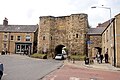 | The walls were built in the 15th century to protect Alnwick against border instability and raiding, and commemorated the powerful local Percy family, who controlled the local castle. [1] [2] |
| Bath | Somerset | | Fragmentary remains | 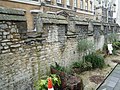 | Bath's first walls were built by the Romans. The Anglo-Saxons established a fortified burh at Bath, utilising the existing walls, and they were further strengthened during the medieval period. Parts of one medieval gatehouse still survive. [3] [4] |
| Beaumaris | Anglesey | | Vestiges | 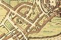 | The town was captured by Owain Glyndŵr in 1400. Once recaptured by English forces, a stone wall with three gates was built around the town, and maintained until the late 17th century. [5] [6] |
| Berwick-upon-Tweed | Northumberland | | Substantially intact | 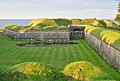 | The first walls built in the early 14th century under Edward I were 2 mi (3.2 km) long. Replaced in 1560 by a set of Italian-inspired walls with 5 large stone bastions, the walls are today the best-preserved post-medieval town defences in England. [7] |
| Beverley | East Riding of Yorkshire | | Substantial remains |  | 12th century Beverley was protected by a "great ditch" rather than a stone wall. In the early 15th century 3 brick gatehouses were built; more ditches and other fortifications were later added, but these failed to protect the town during the Civil War. [8] [9] |
| Bolsover | Derbyshire | Probably 11th or 12th century. | Vestiges |  | Bank and ditch rampart, approximately 8m in width at the base and varying between 3m and 2m in height. [10] |
| Brecon | Powys | | Vestiges |  | Originally constructed by Humphrey de Bohun after 1240, the walls were built of stone, with 4 gatehouses and 10 semi-circular bastions. They were largely destroyed during the Civil War. [11] [12] |
| Bridgnorth | Shropshire | | Vestiges |  | Bridgnorth's town walls were initially constructed in timber between 1216 and 1223; murage grants allowed them to be upgraded to stone between the 13th and 15th centuries including 5 gates. |
| Bristol | Bristol | | Fragmentary remains | 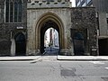 | The fine St John's Gate is built into the Church of St John the Baptist under its spire; the line of the walls is walkable. [13] |
| Caerleon | Newport | | Fragmentary remains |  | [14] |
| Caernarfon | Gwynedd | 1283–92 | Largely intact |  | Constructed by Edward I at a cost of £3,500, alongside the castle, the walls are 2,408 ft (734 m) long and include eight towers and two gatehouses. Today they form part of the UNESCO world heritage site administered by Cadw. [15] [16] |
| Caerwent | Monmouthshire | | Substantial remains |  | [17] |
| Canterbury | Kent | 3rd-16th centuries | Substantial remains |  | First built by the Romans in the 3rd century, retained by the Anglo-Saxons, the walls were rebuilt in the late 14th century owing to fears of a French invasion and feature early gunports. Over half of the original circuit, with 17 out of 24 towers, survives. [18] |
| Cardiff | Cardiff | 12th-15th centuries | Vestiges | 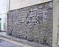 | First recorded in 1111, the walls were 1.28 mi (2.06 km) long and 10 ft (3.0 m) high with 5 town gates. Sections collapsed in the 18th century, many stones being reused as building material. The last large section was demolished in 1901. One of the town gates remains just west of the castle, the "West Gate". [19] |
| Carlisle | Cumbria | | Substantial remains |  | [20] |
| Castle Acre | Norfolk | | Fragmentary remains |  | [21] |
| Chepstow | Monmouthshire | | Substantial remains |  | A late thirteenth century stone wall constructed for the twin purposes of defence and tax collection. [22] |
| Chester | Cheshire | 70 AD–12th century | Largely intact |  | Chester's walls were originally built by the Romans between 70 and 80 AD and were used by the burh in 907. The Norman walls were extended to the west and the south to form a complete circuit, which now provides a walkway of about 2 mi (3.2 km). [23] [24] |
| Chichester | West Sussex | | Substantial remains |  | [25] |
| Cirencester | Gloucestershire | 3rd–4th century | Vestiges | | Remnants of the stone walls of the Roman town of Corinium Dobunnorum are visible in the Abbey Grounds. [26] |
| Colchester | Essex | | Substantial remains |  | The walls were built between 65 and 80 AD after the destruction of the town by Boudicca, and they continued in use until after the Siege of Colchester in 1648. Two large stretches survive on the west and north sides and a number of fragments are visible along the rest of the circuit nearly 2 miles (3.2 kilometres). The Balkerne Gate is the most complete Roman gateway in the United Kingdom. [27] |
| Conwy | Conwy | | Largely intact |  | Constructed between 1283 and 1287 after the foundation of Conwy by Edward I, the walls are 0.8 mi (1.3 km) long, with 21 towers and 3 gatehouses, and formed an integrated system of defence alongside Conwy Castle. [28] [29] |
| Coventry | West Midlands | 1350s–1534 | Fragmentary remains | | With its walls nearly 2.2 mi (3.5 km) around and 12 ft (3.7 m) high, with 32 towers and 12 gatehouses, repaired during the 1640s, Coventry was described as being the best-defended city in England outside London. [30] [31] |
| Cowbridge | Vale of Glamorgan | | Substantial remains |  | [32] |
| Cricklade | Wiltshire | | Fragmentary remains | | [33] |
| Denbigh | Denbighshire | | Substantial remains |  | [34] |
| Dover | Kent | | Vestiges | | Medieval town walls, probably 14th century in date. No structures survive above ground. Tablets mark the sites of Snar Gate, Cow Gate, and Biggin Gate. During building clearance in 1962, foundations of the town wall were encountered along the south side of Townwall Street. [35] [36] |
| Durham | County Durham | | Fragmentary remains | | [37] |
| Exeter | Devon | | Substantial remains |  | Exeter's walls survive as a circuit approximately 2.35 km long, of which 72% (1,705m) is still visible, some parts up to 2.5m high. Originally built by the Romans in circa 200 AD, there were four gateways which were dismantled in the 18th and 19th centuries. The walls were repaired and rebuilt during the Anglo-Saxon, medieval and Civil War periods and the city was besieged at least twice. Several turrets and bastions in the wall are of uncertain date. [38] |
| Frome | Somerset | Pre 1730 | Substantial Remains |  | One of Frome's most ancient structures, the Old Town Wall, runs along from Bath Street through into upper Saxonvale below Lidl, whilst the Old Slaughterhouse facade with its blocked in coach arches and mixture of dressed and rubble stone sections is architecturally of significance in assessing the surviving fabric of previous barton buildings. [39] |
| Gloucester | Gloucestershire | Roman and medieval | Vestiges |  | Foundations of 11th and 13th century East Gate visible through glass panels in Eastgate Street. [40] Another fragment of Roman wall is visible in the City Museum. [41] |
| Great Yarmouth | Norfolk | | Substantial remains |  | [42] |
| Hartlepool | County Durham | | Substantial remains |  | [43] |
| Hastings | East Sussex | | Vestiges |  | [44] |
| Haverfordwest | Pembrokeshire | | Vestiges | | [45] |
| Hay-on-Wye | Powys | | Vestiges | | [46] |
| Hereford | Herefordshire | | Fragmentary remains |  | [47] |
| Horncastle | Lincolnshire | Circa 300 AD | Fragmentary remains |  | Perhaps part of a 4th-century Roman coastal defence system. Remnants of all four walls and a circular bastion survive. [48] |
| Ilchester | Somerset | | Vestiges | | [49] |
| Kidwelly | Carmarthenshire | | Substantial remains |  | [50] |
| Kings Lynn | Norfolk | | Fragmentary remains |  | [51] |
| Kingston upon Hull | East Riding of Yorkshire | 14th century | Vestiges |  | Built of brick in the 14th century, with 4 main gates and up to 30 towers, the walls were maintained until the early 1700s. They were demolished during the building of the docks, beginning in the 1770s. [52] |
| Langport | Somerset | | Fragmentary remains | 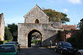 | [53] |
| Launceston | Cornwall | | Substantial remains |  | [54] |
| Lewes | East Sussex | | Vestiges | 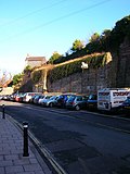 | [55] |
| Lincoln | Lincolnshire | | Fragmentary remains | 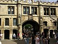 | [56] |
| London | London | | Fragmentary remains | 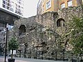 | Built by the Romans and maintained until the 18th century, nearly 3 mi (4.8 km) long, the wall defined the boundaries of the City of London with the Thames to the south. Short sections remain near the Tower of London and in the Barbican area. [57] |
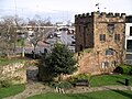
| Ludlow | Shropshire | 1233–1317 | Fragmentary remains |  | Built to defend this Welsh Marches market town, the walls remain in sections, as does the Broad Gate (shown in photo). The large Ludlow Castle is now a ruin but with substantial remains. [58] |
| Malmesbury | Wiltshire | | Vestiges | | [59] |
| Monmouth | Monmouthshire | 13th–15th century [60] | Substantial remains |  | Originally formed a circuit wall with four gatehouses, none of which survive. The fortified Monnow bridge still remains, the only surviving medieval bridge gate in the UK. [61] |
| Newark-on-Trent | Nottinghamshire | | Vestiges | | [62] |
| Newcastle upon Tyne | Tyne and Wear | | Substantial remains |  | Built during the 13th and 14th centuries the wall was about 2 mi (3.2 km) long, 6.5 ft (2.0 m) thick and 25 ft (7.6 m) high, with 6 main gates. The town was successfully defended twice; but during the Civil War the wall was breached using mines and artillery. [63] |
| Northampton | Northamptonshire | 11th–17th century | | | Destroyed by Royal order in 1662 [64] |
| Norwich city walls | Norfolk | | Fragmentary remains |  | |
| Nottingham | Nottinghamshire | 1267-1334 | Vestiges | | A fragment of the wall is visible in a hotel complex near Chapel Bar. [65] |
| Oxford city walls | Oxfordshire | | Fragmentary remains |  | [66] |
| Pembroke | Pembrokeshire | 11th - 13th century | Largely intact | 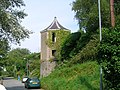 | A medieval town sitting atop a limestone peninsular linked to Pembroke Castle (1093). (Listed Ancient Monument).The walls are virtually intact on the north side along the River Pembroke together with the intact structure to the east that is Barnard's Tower (mini fortress). 75% of walls survive along the south side (The Commons) including a Lime-kiln, Gun Platform, two towers, the top of one surmounted by a Gazebo. All the walls are listed and many buildings on the wall and in the town are listed Ancient Monuments. The burgage plots within the town are divided by medieval stone walls and are of national importance.The mighty Pembroke Castle sits at the Western tip of the peninsular.The walk around the castle and town walls is some 1.5 miles. [67] |
| Poole | Dorset | | Vestiges | | [68] |
| Portsmouth | Hampshire | 14th–18th century | Fragmentary remains | 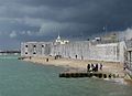 | First constructed of earth and timber, probably in the late 14th century, [69] the walls were repeatedly repaired and rebuilt until the mid 18th century. They were largely removed in the 1870s and 80s. [69] |
| Richmond | North Yorkshire | | Fragmentary remains |  | [70] |
| Rochester | Kent | | Fragmentary remains |  | [71] |
| Rye, East Sussex | East Sussex | | Substantial remains |  | [72] |
| Salisbury | Wiltshire | 14/15th century | Substantial remains |  | North Gate. Two-storey building over and around north entrance to the Cathedral Close. |
| Sandwich | Kent | | Fragmentary remains |  | [73] |
| Scarborough | North Yorkshire | 15th century | Fragmentory remains |  | Two small sections of wall survive. [74] |
| Shrewsbury | Shropshire | 13th–14th century | Fragmentary remains |  | Begun in the 13th century after attacks by the Welsh, adding to the natural defences of the Severn, the walls were strengthened by the Royalists during the Civil War. A medieval watch tower and short sections remain, notably along the street named Town Walls. [75] |
| Silchester | Hampshire | 3rd century | Substantial remains | 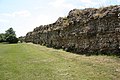 | The Roman town of Calleva Atrebatum was abandoned around the 5th or 6th century. Much of the walls survive, the area within them largely farmland. [76] |
| Southampton | Hampshire | | Substantial remains |  | Built after French raids in 1338, the walls were 1.25 mi (2.01 km) long, with 29 towers and 8 gates. They were amongst the first in England to have new technology installed to existing fortifications, with new towers built specifically to house cannon. [77] |
| Stafford | Staffordshire | | Vestiges | 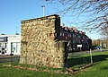 | |
| Stamford | Lincolnshire | | Fragmentary remains | 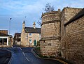 | [78] |
| Swansea | Swansea | | Vestiges | 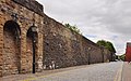 | [79] |
| Tenby | Pembrokeshire | | Substantial remains |  | [80] |
| Totnes | Devon | 14th century | Fragmentary remains |  | Remains include the Baste Walls, South Street and the Eastgate, which was greatly altered in the 19th century. [81] |
| Verulamium | Hertfordshire | 2nd-3rd century | Fragmentary remains |  | The site of the Roman town of Verulamium was abandoned when the later settlement of St. Albans was established nearby. [82] |
| Warkworth | Northumberland | | Fragmentary remains | 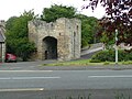 | [83] |
| Wareham | Dorset | 9th-11th century | Substantial remains |  | Earthwork defences first mentioned in 876 surround the town on the north, east and west sides; the south side is bounded by the River Frome. The West Walls were scarped against attack by tanks in 1940. [84] |
| Warwick | Warwickshire | | Fragmentary remains | 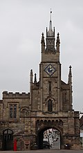 | [85] |
| Winchelsea | East Sussex | | Substantial remains |  | [86] |
| Winchester | Hampshire | | Substantial remains |  | [87] |
| Worcester | Worcestershire | 1st–12th century | Vestiges |  | First built by the Romans, the walls were extended by the Anglo-Saxons to create a walled burh. A longer circuit of stone walls was built in the late 12th century and further fortified during the Civil War. [88] [89] |
| York | North Yorkshire | 3rd–14th century | Largely intact | 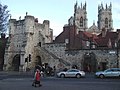 | 2.5 mi (4.0 km) long, enclosing an area of 263 acres, [90] the defences are the best preserved in England. On high ramparts, retaining all their main gateways, [91] the walls incorporate Roman, Norman and medieval work with modern renovations. [92] |