The Vale of Glamorgan, often referred to as The Vale, is a county borough in the south-east of Wales. It borders Bridgend County Borough to the west, Cardiff to the east, Rhondda Cynon Taf to the north, and the Bristol Channel to the south. With an economy based largely on agriculture and chemicals, it is the southernmost unitary authority in Wales. Attractions include Barry Island Pleasure Park, the Barry Tourist Railway, Medieval wall paintings in St Cadoc's Church, Llancarfan, Porthkerry Park, St Donat's Castle, Cosmeston Lakes Country Park and Cosmeston Medieval Village. The largest town is Barry. Other towns include Penarth, Llantwit Major, and Cowbridge. There are many villages in the county borough.

Cowbridge is a market town in the Vale of Glamorgan, Wales, approximately 12 miles (19 km) west of the centre of Cardiff.

South Glamorgan is a preserved county of Wales.

Llantwit Major is a town and community in Wales on the Bristol Channel coast. It is one of four towns in the Vale of Glamorgan, with the third largest population after Barry and Penarth, and ahead of Cowbridge. It is 4+1⁄2 miles (7.2 km) from Cowbridge, 9 miles (14 km) from Bridgend, 10 miles (16 km) from Barry, and 15 miles (24 km) from Cardiff. It had a population of 9,530 in 2021.

Colwinston is both a village and a community in the Vale of Glamorgan, Wales, approximately 4 miles (6.4 km) southeast of the centre of Bridgend and 21 miles (34 km) west of the centre of Cardiff. The village is located within 1⁄2 mile (0.80 km) of the A48. The population in 2005 was approximately 400 but with recent building development, the population is now estimated at over 600 people.

Vale of Glamorgan is a constituency represented in the House of Commons of the UK Parliament since 2010 by Alun Cairns, a Conservative.

Aberthaw is an area containing the villages of East Aberthaw and West Aberthaw, on the coast of South Wales about 5 miles (8 km) west of Barry. It is home to Aberthaw Cement Works, Aberthaw Lime Works, and Aberthaw Power Station, a decommissioned coal power station that was linked to the South Wales Valleys via the Vale of Glamorgan Railway. The area is historically within the parish of Penmark in the Vale of Glamorgan. The two villages of West and East Aberthaw are separated by the River Thaw. The village of East Aberthaw, near Rhoose, has a 13th-century pub. The village Baptist Chapel and Mission Room no longer exist as such and have been converted for other uses.

Llancarfan is a rural village and community in the Vale of Glamorgan, Wales. The village, located west of Barry and near Cowbridge, has a well-known parish church, the site of Saint Cadoc's 6th-century clas, famed for its learning. Cainnech of Aghaboe, Caradoc of Llancarfan and many other Welsh holy men studied there. Antiquarian Iolo Morganwg was born in the hamlet of Pen-onn near Llancarfan. At the 2001 census, the community had a population of 736. In the 2011 census, the population was 747. Most of the village lies within a conservation area designated by the local authority in 1971. Buildings listed as being of special historic interest include The Fox and Hounds public house, the former Bethlehem Chapel, the former Wesleyan Chapel, Chapel Cottage, Great House, Corner House and Llancarfan Primary School. The community includes village of Moulton.

Nidum is a Roman fort found in Cwrt Herbert near the town of Neath, in Wales. An Auxiliary fort first built in around 74AD from earth banks and wooden structures, it underwent a reduction in size from 3.3 to 2.3 hectares soon afterwards. It may have been garrisoned by perhaps 500 Auxiliary troops. It was abandoned in around 125AD, but re-occupied around 140AD when it was rebuilt in stone. However it was only occupied until 170AD, with 100 years of disuse before a final period in use from AD 275 and 320.

Cowbridge with Llanblethian is a community in the Vale of Glamorgan, Wales, which incorporates Llanblethian and the town of Cowbridge. It also covers the village of Aberthin to the northeast of Cowbridge. The population was 4,063 in 2011.

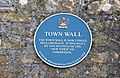
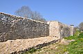
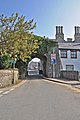
Cowbridge was a small castra in Roman Wales within the Roman province of Britannia Superior. Today the contemporary settlement, Cowbridge, has a population of roughly 3,600.
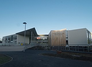
Cowbridge Comprehensive School is a secondary school in the town of Cowbridge, Vale of Glamorgan, near Cardiff, Wales.
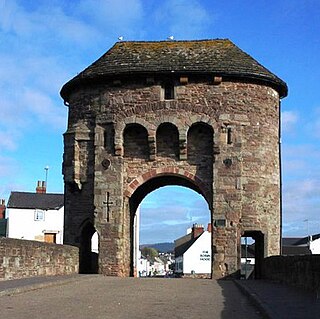
The Monmouth town walls and defences comprise the defensive system of town walls and gates built in Monmouth, Wales between 1297 and the early part of the following century. Wye Bridge Gate, East Gate, Monk's Gate, and Monnow Bridge Gate were access points to the town. West Gate, across Monnow Street, also provided access. Only the Monnow Bridge Gatehouse survives intact, albeit in a substantially modified version from the original.
A bibliography of books related to the Vale of Glamorgan, south Wales.
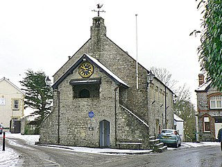
Cowbridge Town Hall is a public building in the High Street of Cowbridge in South Wales. The town hall, which is the meeting place for Cowbridge with Llanblethian Town Council, and also houses the town clerk's office, the committee rooms and the Cowbridge Museum, is a Grade II* listed building.
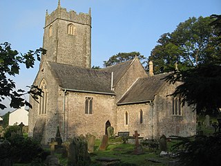
The Church of St John the Baptist is a medieval church in Llanblethian in the Vale of Glamorgan, south Wales. Believed to have been built in the 12th century, the church boasts an unusual tower, consistent with the style more common in the south west of England. It underwent extensive restoration in the late 19th century, undertaken by C. B. Fowler of Cardiff. The Church of St John was listed as a Grade I building on 22 February 1963.
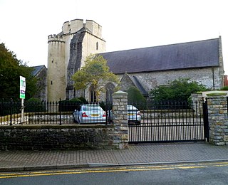
The Church of the Holy Cross is a medieval church in Cowbridge in the Vale of Glamorgan, south Wales. Initially a chapel of ease to Church of St John the Baptist, Llanblethian of Cowbridge as a medieval market town. Believed to have been built in the 13th century, the church has an unusual tower design. It has undergone several restorations including one by John Prichard in 1850–52. The Church of the Holy Cross was listed as a Grade I building on 12 May 1963.
Llantwit Major Town Hall is a local government administrative building dating back to the late 15th century, in the town of Llantwit Major in the Vale of Glamorgan, Wales. It is a Grade II* listed building.

Llanfair is a community in the Vale of Glamorgan, Wales. It is located immediately south of the town of Cowbridge and includes the settlements of St Hilary, Llandough, St Mary Church and The Herberts. The population in 2011 was 611.
Cowbridge is the name of an electoral ward in the Vale of Glamorgan, Wales, which covers its namesake town of Cowbridge as well as the neighbouring villages of Llanblethian and Aberthin and the communities of Llanfair and Penllyn. The ward elects three county councillors to the Vale of Glamorgan Council.