Monmouth town walls and defences

Last updated

Monmouth town walls and defences
DYKGatehouse.jpg
Monnow Bridge Gatehouse, part of the Monmouth town walls and defences
Monmouth town walls and defences
General information
Location Monmouth, Monmouthshire, Wales
Openedcirca 1300

The Monmouth town walls and defences comprise the defensive system of town walls and gates built in Monmouth, Wales between 1297 and the early part of the following century. Wye Bridge Gate, East Gate (Dixton Gate), Monk's Gate, and Monnow Bridge Gate were access points to the town. West Gate, across Monnow Street, also provided access. Only the Monnow Bridge Gatehouse survives intact, albeit in a substantially modified version from the original.

Contents

Background

The castle of Monmouth was originally built by the Normans in the late 11th century, as one part of a system of fortifications to help establish their dominance of the Welsh Marches, and as a base for extending their control into Wales itself. [1] The castle, which overlooked the confluence of the rivers Wye and Monnow in a strategically important border area, was initially a modest motte and bailey structure, rebuilt in stone by 1150. [2] A small market town developed around the castle and, in 1267, it passed into the hands of Edmund Crouchback, Earl of Lancaster and son of Henry III. In turn, it passed to his own son Henry de Lancastre. On 27 August 1297, he petitioned his uncle, Edward I, to issue a murage grant for the town. [3] The 1297 grant was issued for five years and the funds collected allowed for the construction of the medieval town walls and gates. [4]

Construction and extent

On 1 June 1315, again at Henry de Lancastre's request, the grant was renewed for another three years, indicating that the project was either incomplete or in need of repairs. The murage indicated that the levy was to be on "all wares brought for sale into the town." [5] Town walls were regarded as necessary for several reasons: they provided defensive protection for the Anglo-Normans against the sometimes hostile Welsh inhabitants of the nearby countryside, they protected and allowed the policing of the market, and they allowed the easier collection of taxes and dues. [6] The walls and gates also served as a status symbol. [4] In addition to their defensive use, the town gates were utilised for hundreds of years to collect tolls. These were authorised by the patent rolls of 1297 and 1315. [5]

The complete course of the stone walls is uncertain. Gate towers were erected on Monnow Bridge and at several other locations, including Monk's Gate, Dixton Gate, Wye Gate, West Gate and St Stephen's Gate (the last providing access to the bailey of the castle). [7] According to John Leland, who visited the town circa 1538, a ruined wall extended around the town at that time, together with a deep ditch or fosse. [6]

Monnow Bridge Gatehouse

The Monnow Bridge Gatehouse is the most renowned and visible portion of the Monmouth town walls and defences. Combined with the Monnow Bridge for purposes of listing, the gatehouse is both a scheduled ancient monument and a Grade 1 listed building. The bridge and gatehouse were listed on 15 August 1974. [8] [9] [10] [11] The bridge on which it stands is a three span stone bridge built around 1272. [12] [13] [14] The gatehouse in the centre of the bridge was added between 1297 and 1315, at the time of the construction of the town's stone walls. [8] [11] [12] [13] The bridge and gate at that time were very different from the present versions. Not only was the bridge narrower, the gate had a single archway with a portcullis. [8] [13] [15] The roof of the gatehouse was lower, and featured a parapet with battlements. [12] In addition, the machicolation arches on the facade of the gate were added later. [12] [16]

By 1705, the Monnow Bridge Gatehouse was in need of maintenance, and the Monmouth Common Council ordered that it be repaired and upgraded. The castellated parapet had its battlements rebuilt as solid walls, and the roof was raised, producing a two-storey house. [9] [12] [15] In addition, a timber framed lean-to extension was added adjacent to the eastern corner of the gate. [15] While the gatehouse had been converted to a dwelling, a portion of it or the adjacent lean-to was utilised as a lock-up or guardroom when needed. The lean-to was demolished in 1815. In the early and mid 19th century, smaller pedestrian side arches were cut through the flanking towers, the upstream arch in 1819 and the downstream arch in 1845. [4] [8] [9] [11] [12] In 1832, the gatehouse roof was rebuilt. [12]

Monnow Bridge served as an outer defence on the west, and provided access between the suburb of Overmonnow and Monnow Street, which led to Monmouth Castle and market. [8] The gatehouse was last fortified and occupied by soldiers in 1839 at the time of threatened attacks by the Chartists from Newport, an event which did not materialise. [8] [9] [11] In March 2004, a new bridge was opened downstream of Monnow Bridge; on that same day, the old bridge was pedestrianised, such that there is only pedestrian traffic through the Monnow Bridge Gatehouse. The changes improved traffic flow on Monnow Street. [17] [18] Monnow Bridge is now the only surviving medieval fortified bridge in Britain with a gatehouse which is positioned on the bridge. [8] [12] [13]

Remainder including East Gate

1610 map of Monmouth, Wales by cartographer John Speed Old map of Monmouth, Wales.jpg
1610 map of Monmouth, Wales by cartographer John Speed
Remnant of Dixton Gate tower, also a portion of the Monmouth town walls and defences Rear of Nags Head Monmouth showing the stone work of Monmouth's Dixton Gate.JPG
Remnant of Dixton Gate tower, also a portion of the Monmouth town walls and defences

The Monmouth town walls and defences are listed with Cadw and also have records with the Glamorgan-Gwent Archaeological Trust. The Monnow Bridge Gatehouse, part of the town walls and defences, is listed separately due to its particular interest. Aside from the tower which is incorporated into the Old Nag's Head pub, there are no other surviving upstanding remains of the Monmouth town walls. Despite this, archaeological excavations have determined portions of the circuit of the town's defences. Coordinates: 51°48′47″N2°42′38″W / 51.81318°N 2.71045°W / 51.81318; -2.71045 [19] [20] [21] [22]

The gates of the Monmouth town walls survived the walls themselves. However, Monk's Gate, near the Priory, was removed in 1710; it is feasible that the curved wall at the Masonic Hall entrance indicates its previous location. Wye Gate at Wye Bridge is also gone. [4] [22] An 1886 article in Archaeologia Cambrensis by William Bagnall-Oakeley, husband of antiquarian Mary Ellen Bagnall-Oakeley, discussed Monmouth and included an analysis of the 1610 map of Monmouth by cartographer John Speed, comparing it with the account of the circa 1538 visit by antiquarian John Leland, also Leyland. Bagnall-Oakeley described Leland's account of a town wall with four gates, Wye, East, Monk's, and Monnow, with a wall that extended to the River Monnow, as incorrect. [7] Instead, Bagnall-Oakeley referred to Speed's map which apparently demonstrated a town wall which ended at the top of Monnow Street, near the Bayley (bailey). The author indicated that Speed referred to the gate at the top of Monnow Street as the West Gate, although there is no label to that effect on the map. [7] Rather, the gate on Speed's map apparently represented St Stephen's Gate. [7] [23] The author indicated that there had been remains of a gate at that position "a few years" previously, which had been used as a gaol. Bagnall-Oakeley felt that the gate was St Stephen's Gate and that it provided access from the town to the outer bailey of Monmouth Castle. [7] Based on his examination of the area with another Monmouth resident and his reading of military accounts, the author speculated that there might have been an additional, sixth gate, lower down on Monnow Street, expressing some disagreement with both Leland and Speed. [7] That sixth gate, the West Gate, may be the one referred to by author William Meyler Warlow. He indicated that the medieval town wall ran from the River Monnow, in the vicinity of the Priory Mill, across Monnow Street, just above the level of Nailers Lane. That there was a gate with a drawbridge over a ditch at that level is confirmed by the Glamorgan-Gwent Archaeological Trust Historic Environment Record. [24] [25]

Most of the East Gate, also known as Dixton Gate, was removed in 1770 because it prevented the passage of coaches. [4] [22] Aside from the Monnow Bridge Gatehouse which is given a separate listing as a scheduled monument due to its special interest, the only standing remnant of the Monmouth town walls and defences is the medieval Dixton Gate tower which was incorporated into the Old Nag's Head public house. [22] [23] [26] The lower storey of the gate tower is older and has a battered base; the upper storey of the red sandstone tower has 19th century work. The red sandstone tower of the East Gate, part of Monmouth's defences, is on Old Dixton Road. [27] The Old Nag's Head Public House is also a listed building of Grade II*. [28] The building was given a higher grade due to its interest not only in its own right, but also because of the incorporation of a significant portion of the gate tower. [21] In February 2012, proposed renovation of the building adjoining the medieval East Gate led to the recommendation of an archaeological field evaluation. [26]

Rivers

The town of Monmouth is nestled between the River Monnow and the River Wye, just northwest of their confluence. [29] The name of the town was derived from its location at the junction of the two rivers. Monmouth is the contraction of Monnow and mouth. The Welsh name for the river, Mynwy, which may originally have meant "fast-flowing", was anglicised as Monnow. The town was originally known in Welsh as Abermynwy ("mouth of the Monnow"), replaced by Trefynwy ("Monnow town" – the initial m of Mynwy mutating in Welsh to f) by the 17th century. [30]

The natural defences afforded by the Monnow and the Wye in conjunction with constructed Monmouth town walls and defences provided protection to the town. William Bagnall-Oakeley, again in reference to Speed's map, described a rampart and fosse (defensive wall and ditch) which extended from the top of Monnow Street behind the houses in a line to the River Wye, then turning to the Wye Gate. [7] The rampart and fosse then extended to Dixton Gate and, from there, to Monk's Gate and the bank of the River Monnow. After circling around the castle, it joined again at the top of Monnow Street. [7] Thus, while the entire circuit of the walls is not known, the walls and ditches were constructed in close association with the rivers. In addition, Clawdd-du, the defensive ditch which surrounded the Monmouth suburb of Overmonnow, provided further fortification of the area. [15] [31] [32] However, as the Monnow River was fairly shallow and narrow, it could be crossed easily upstream. Therefore, while the Monnow Bridge and Gate were built mainly for defensive purposes, ultimately their primary function was financial; they were utilised to collect tolls. [15]

See also

Related Research Articles

Monmouth Town in Monmouthshire, Wales

Monmouth is a town and community in Wales. It is situated where the River Monnow joins the River Wye, 2 miles (3.2 km) from the Wales–England border. Monmouth is 30 miles (48 km) northeast of Cardiff, and 113 miles (182 km) west of London. It is within the Monmouthshire local authority, and the parliamentary constituency of Monmouth. The population in the 2011 census was 10,508, rising from 8,877 in 2001. Monmouth is the historic county town of Monmouthshire although Abergavenny is now the county town.

Monmouthshire County in Wales

Monmouthshire is a county in the south-east of Wales. The name derives from the historic county of the same name; the modern county covers the eastern three-fifths of the historic county. The largest town is Abergavenny, with other towns and large villages being: Caldicot, Chepstow, Monmouth, Magor and Usk. It borders Torfaen, Newport and Blaenau Gwent to the west; Herefordshire and Gloucestershire to the east; and Powys to the north.

Monnow Bridge Grade I listed building and bridge in Monmouth, south-east Wales

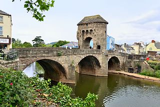
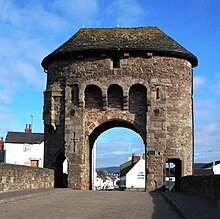
Monnow Bridge, in Monmouth, Wales, is the only remaining fortified river bridge in Great Britain with its gate tower standing on the bridge. Such bridge towers were common across Europe from medieval times, but many were destroyed due to urban expansion, diminishing defensive requirements and the increasing demands of traffic and trade. The historical and architectural importance of the bridge and its rarity are reflected in its status as a scheduled monument and a Grade I listed building. The bridge crosses the River Monnow 500 metres (1,600 ft) above its confluence with the River Wye.

Dixton Human settlement in Wales

Dixton is a small village located 1 mile (1.6 km) north east of Monmouth, on the banks of the River Wye, in Monmouthshire, south east Wales. The parish originally comprised the two manors of Dixton Newton and Dixton Hadnock, on either side of the river.

Monmouth Castle

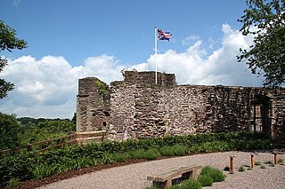
Monmouth Castle is a castle close to the centre of the town of Monmouth, the county town of Monmouthshire, on a hill above the River Monnow in south east Wales.

Wye Bridge, Monmouth

The Wye Bridge in Monmouth is a bridge across the River Wye. The A466 passes over it and immediately meets the A40 at its western end. The bridge is a grade II listed building. The total span of the bridge is 71 metres (233 ft).

Monmouth Priory Benedictine priory in Monmouth, Wales

Monmouth Priory, in Priory Street, Monmouth, Wales, is a building that incorporates the remains of the monastic buildings attached to St Mary's Priory Church. The priory was a Benedictine foundation of 1075, and parts of the mediaeval buildings remain. The buildings were substantially redeveloped in the nineteenth century for use as St Mary's National School, and now form a community centre. The complex is a Grade II* listed building as of 27 June 1952. It is one of 24 sites on the Monmouth Heritage Trail.

St Peters Church, Dixton Church in Monmouthshire, Wales

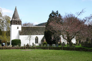
St. Peter's Church is a Church of England parish church at Dixton. It is situated on the banks of the River Wye, about 1 mile (1.6 km) north-east of Monmouth, Wales. The church is a Grade II* listed building and the cross in the churchyard is both a listed building and a scheduled monument.

Old Nags Head, Monmouth

The Old Nag's Head, Old Dixton Road, Monmouth, Wales, is a nineteenth-century public house, with medieval origins, which incorporates a "stone drum tower of the town defences constructed between 1297 and c.1315." The tower is the only "upstanding remains of the town walls of Monmouth." The pub was designated a Grade II* listed building on 26 April 1955, its rating being due to "its interest as an early C19 public house which retains its character as well as a significant portion of a medieval gate-tower."

Osbaston, Monmouth Human settlement in Wales

Osbaston is a suburb of Monmouth, Wales, located less than 1 mile (1.6 km) north of the town centre. It was the site of one of the first public electricity generating stations in Britain, using water power from the River Monnow.

Mary Ellen Bagnall-Oakeley English artist and antiquarian (1833–1904)

Mary Ellen Bagnall-Oakeley (1833–1904) was an English antiquarian, author, and painter known for her work in Bristol and south-east Wales. She was a governor of the Haberdashers' Monmouth School for Girls and the mother of nine children.

St James Square, Monmouth

St James Square is a historic square in the town centre of Monmouth, Monmouthshire, Wales. It is located at the eastern end of Whitecross Street, within the medieval town walls. The area features the Monmouth War Memorial and the controversial, historic Indian Bean Tree. In addition, in 2010, the square was the site of discovery of the first Mesolithic artefacts in Monmouth. St James Square is lined with numerous listed buildings. It is also home to the Monmouth Catalpa Tree.

St James Street, Monmouth

St James Street is a historic street in the town centre of Monmouth, Monmouthshire, Wales. It appears as a segment of Whitecross Street on the 1610 map of the town by cartographer John Speed and is within the medieval town walls. On more recent maps, it extends from St James Square southwest to Almshouse Street. In 2010, the street was the site of discovery of Mesolithic era artefacts. St James Street is lined with numerous listed buildings.

St James House, Monmouth

St James House is a grade II listed building in Monmouth, Monmouthshire, Wales. It is in the historic St James Square neighbourhood, within the Medieval town walls. While the house currently has an attractive, 18th-century facade, it originated as a burgage tenement. In addition, behind the house, evidence of a kiln has been unearthed, with both Medieval and Post-medieval pottery. In 2010, archaeological excavation in the square revealed the first evidence of Mesolithic human settlement in Monmouth. Recent residents of St James House have included boarding students from Monmouth School.

Glendower Street, Monmouth

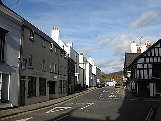
Glendower Street is a historic street in the town centre of Monmouth, Monmouthshire, Wales. It extends to the southeast from the intersection of Agincourt Street and St John's Street, within the medieval town walls. Glendower Street is lined with numerous listed buildings, including one of the 24 blue plaque buildings on the Monmouth Heritage Trail.

Monmouth Police Station

The Monmouth Police Station is a Grade II listed building in the town centre of Monmouth, Monmouthshire, Wales. It is located in the historic Glendower Street neighbourhood, within the medieval town walls. In March 2012, it was announced that the Monmouth Police Station was one of seventeen police stations in South East Wales that would no longer be open to the public.

Druids Head Inn

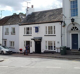
The Druid's Head Inn is a grade II listed building in the town centre of Monmouth, Monmouthshire, Wales. It is located in the historic Glendower Street and Chippenhamgate Street neighbourhood, within the medieval town walls. The building served as a public house during most of its history, but for the last several decades has been the headquarters of the Monmouth Rugby Football Club.

St Johns, Monmouth

St John's is a grade II listed building in the town centre of Monmouth, Monmouthshire, Wales. It is located in the historic Glendower Street neighbourhood, within the medieval town walls. The eight bedroom home is most remarkable for the rear of the property which features a Coalbrookdale verandah and formal walled garden that have been separately grade II listed with the Cadw/ICOMOS Register of Parks and Gardens of Special Historic Interest in Wales. The villa's garden is also registered with the Welsh Historic Gardens Trust.

Newton Court Building in Monmouth, Wales

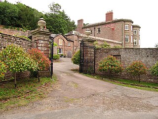
Newton Court is a neoclassical house, completed in 1802, situated on the hillside above Dixton, 1 mi (1.6 km) north-east of the town on Monmouth, in Monmouthshire, Wales. It is a Grade II* listed building. The stable block is listed as a Site of Special Scientific Interest (SSSI), noted for as a breeding site for lesser horseshoe bats.

Inglis Bridge, Monmouth Grade II listed building and bridge in Monmouth, south-east Wales

The Inglis Bridge, Monmouth, Wales crosses the River Monnow linking Vauxhall Fields and the suburb of Osbaston. Designed by, and named after, Charles Inglis, the bridge was constructed in 1931 and refurbished in 1988. It is a Mark II model of an Inglis bridge, and the only known example in Britain of such a bridge still in public use. Access is now limited to pedestrians, vehicular use being prohibited in 2018 on safety grounds. The bridge is a Grade II listed structure.

References

  1. Lieberman, Max (2008). The March of Wales, 1067–1300: a borderland of medieval Britain. University of Wales Press. ISBN   978-0-7083-2115-7.
  2. "Places of Interest – Monmouth Castle". monmouth.org.uk. The Monmouth Website. Retrieved 23 March 2012.
  3. Maxwell Lyte, ed. (1895). "Edward I – Part II". Calendar of Patent Rolls Edward I (1292–1301) Vol. 3 (PDF). p. 307. Retrieved 10 May 2012.
  4. 1 2 3 4 5 Keith Kissack (1974). Mediaeval Monmouth (illustrated ed.). Monmouth Historical and Educational Trust. p. 36.
  5. 1 2 Maxwell Lyte, ed. (1898). "Edward II – Part II". Calendar of Patent Rolls Edward II (1313–17) Vol. 2 (PDF). p. 297. Retrieved 10 May 2012.
  6. 1 2 Rowlands, M.L.J. (1994). Monnow Bridge and Gate. Alan Sutton Publishing. ISBN   0-7509-0415-1.
  7. 1 2 3 4 5 6 7 8 "Monmouth". Archaeologia Cambrensis. 1886. p. 14. Retrieved 9 May 2012.
  8. 1 2 3 4 5 6 7 "Monnow Bridge". cofiadurcahcymru.org.uk. The Glamorgan-Gwent Archaeological Trust Historic Environment Record. Retrieved 23 May 2012.
  9. 1 2 3 4 "Monnow Bridge". cofiadurcahcymru.org.uk. The Glamorgan-Gwent Archaeological Trust Historic Environment Record. Retrieved 23 March 2012.
  10. "Monnow Bridge and Gateway, Monmouth". britishlistedbuildings.co.uk. British Listed Buildings. Retrieved 23 March 2012.
  11. 1 2 3 4 "Monnow Bridge and Gate; Western Gate, Monmouth". coflein.gov.uk. Royal Commission on the Ancient and Historical Monuments of Wales. Archived from the original on 6 January 2014. Retrieved 22 May 2012.
  12. 1 2 3 4 5 6 7 8 John Newman (11 March 2000). Gwent/Monmouthshire (illustrated ed.). Yale University Press. p. 402. ISBN   9780300096309 . Retrieved 24 May 2012.
  13. 1 2 3 4 "Monmouth". Town Guides. South Wales Argus. Retrieved 22 May 2012.
  14. "Monnow Bridge, Monmouth, Gwent, Wales". viewfinder.english-heritage.org.uk. English Heritage. Archived from the original on 16 January 2014. Retrieved 24 May 2012.
  15. 1 2 3 4 5 "Places of Interest – Monnow Bridge". monmouth.org.uk. The Monmouth Website. Retrieved 23 May 2012.
  16. Cook, Martin (1998). Medieval Bridges p. 42. Shire Publications. ISBN   0-7478-0384-6.
  17. "Monmouth Town Guide". Monmouth Town Council. December 2011. p. 8. Retrieved 23 May 2012.[ permanent dead link ]
  18. "Monmouth – Building prosperity and civility through place making" (PDF). hamilton-baillie.co.uk. Hamilton-Baillie Associates. Retrieved 1 June 2012.[ permanent dead link ]
  19. "Eastern Gate, Dixton Gate, Monmouth Town Walls". coflein.gov.uk. Royal Commission on the Ancient and Historical Monuments of Wales. Retrieved 10 May 2012.
  20. "Monmouth Town Defences". cofiadurcahcymru.org.uk. The Glamorgan-Gwent Archaeological Trust Historic Environment Record. Retrieved 10 May 2012.
  21. 1 2 "The Old Nag's Head Public House". coflein.gov.uk. Royal Commission on the Ancient and Historical Monuments of Wales. Retrieved 9 May 2012.
  22. 1 2 3 4 Keith Kissack (May 1974). Mediaeval Monmouth. Monmouth Historical and Educational Trust. p. 36. ISBN   9780950338606 . Retrieved 16 May 2012.
  23. 1 2 "Walking in Monmouth, Monmouthshire and The Wye Valley". monmouth.org.uk. The Monmouth Website. Retrieved 9 May 2012.
  24. William Meyler Warlow (1899). A history of the charities of William Jones (founder of the "Golden lectureship" in London), at Monmouth & Newland. W. Bennett. p. 37. Retrieved 23 May 2012.
  25. "West Gate". cofiadurcahcymru.org.uk. The Glamorgan-Gwent Archaeological Trust Historic Environment Record. Retrieved 23 May 2012.
  26. 1 2 "Curatorial Division – Correspondence" (PDF). idox.monmouthshire.gov.uk. Glamorgan Gwent Archaeological Trust Ltd. Archived from the original (PDF) on 16 January 2014. Retrieved 10 May 2012.
  27. John Newman (11 March 2000). Gwent/Monmouthshire (illustrated ed.). Yale University Press. p. 408. ISBN   9780300096309 . Retrieved 9 May 2012.
  28. "The Old Nag's Head P H, Monmouth". britishlistedbuildings.co.uk. British Listed Buildings. Retrieved 9 May 2012.
  29. Thomas Moule (1837). The English Counties Delineated, Volume 2. Virtue. p. 62.
  30. Hywel Wyn Owen, The Place-Names of Wales, 2000, University of Wales Press, ISBN   0-7083-1458-9, p. 63
  31. "Clawdd Du, Overmonnow". coflein.gov.uk. Royal Commission on the Ancient and Historical Monuments of Wales. Archived from the original on 6 January 2014. Retrieved 16 May 2012.
  32. "Monmouth in the County of Monmouthshire Tour and Tourist Information Guide". royalforestofdean.info. Monmouth Tourist Information and Travel Guide. Retrieved 16 May 2012.