Monmouth Heritage Trail

Last updated

The Monmouth Heritage Trail is a walking route which connects various sights in the town of Monmouth, Wales. [1] [ failed verification ]

Contents

History

In 2009 Monmouth Civic Society identified 24 historic and interesting buildings in the town, and organised the production and fixing of ceramic blue plaques to them. The plaques were made by Ned Heywood of Chepstow, with a stoneware body and raised text in both English and Welsh, set off by a blue glaze. The space for text was limited, and each plaque contained a brief summary of the importance of the building to the town. Some choices were obvious, such as the Monnow Bridge and Shire Hall, both symbols of the town and listed buildings. [2] Others were less well known, such as The Nelson Garden or Monmouth Methodist Church, even though townspeople passed them every day. The map and list of Blue Plaque buildings is shown below.

The guide information is available in Welsh, [1] but a larger number of languages are available in Wikipedia. The "MonmouthpediA" project provides visitors with information about all aspects of the town via QRpedia QR codes. [3]

Key

GradeCriteria [2]
Grade IBuildings of exceptional interest, sometimes considered to be internationally important.
Grade II*Particularly important buildings of more than special interest.
Grade IIBuildings of national importance and special interest.

The buildings

No.NamePhotographGradeDateLocation [A] Description
1 Drybridge House Drybridge House 9.JPG II*1671 51°48′32″N2°43′24″W / 51.809°N 2.7233°W / 51.809; -2.7233 (Drybridge House) 
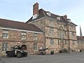
Drybridge House is a large 17th-century Grade II* listed building in Monmouth, south-east Wales. It is located to the southwest of the town, close to the “dry bridge” over a small stream, which is now buried beneath a nearby roundabout. It is now managed as the Bridges Community Centre.
2 St Thomas the Martyr Church St Thomass Church Monmouth Oct 2011 3.jpg II*c.1170 51°48′30″N2°43′13″W / 51.8084°N 2.720408°W / 51.8084; -2.720408 (St Thomas') The Church of St Thomas the Martyr is located beside the medieval Monnow Bridge across the River Monnow. At least part of the building dates from around 1180, and it has a fine 12th-century Norman chancel arch, though the exterior was largely rebuilt in the early 19th century.
3 Monnow Bridge DYKGatehouse.jpg I13 C 51°48′32″N2°43′12″W / 51.809°N 2.7200°W / 51.809; -2.7200 (Monnow Bridge) 
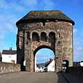
Monnow Bridge is the only remaining mediæval fortified river bridge in Great Britain with its gate tower still standing in place. It crosses the River Monnow some 500m above where it joins the River Wye. It is a scheduled ancient monument.
4 Robin Hood Inn 4 The Robin Hood InnHTsmall.jpg II*late medieval 51°48′34″N2°43′09″W / 51.8095°N 2.7193°W / 51.8095; -2.7193 (Robin Hood Inn) The Robin Hood Inn, Nos. 124 and 126, Monnow Street is a public house of "late medieval" origins. It is constructed in stone, with a wide, fifteenth-century four-centre doorway and is a rare medieval survival in Monmouth.
5 Roman Fort Wales.Roman.Conquest.jpg nac. 55AD 51°48′16″N2°43′24″W / 51.80447°N 2.7233°W / 51.80447; -2.7233 (Roman Fort) Blestium (also Blestio in the Antonine Itinerary (Iter XIII)) was a small fort and iron working centre in the Roman province of Britannia Superior, part of Roman Britain. It has been identified with the site of the later town of Monmouth in south east Wales, located adjoining the confluence of the River Monnow with the River Wye.
6 King's Head Hotel Kings Head Monmouth.jpg II*17 C 51°48′43″N2°42′57″W / 51.811935°N 2.715721°W / 51.811935; -2.715721 (King's Head) The King's Head Hotel is opposite the Shire Hall in Agincourt Square. It dates from the mid-17th century, and as one of the major inns in Monmouth was reputedly visited by Charles I of England in 1645. It has a fine black-and-white painted stone façade and became an important posting inn in the late 17th century.
7 Shire Hall Agincourt Square, Monmouth - geograph.org.uk - 649050.jpg I1724 51°48′43″N2°42′55″W / 51.811973°N 2.715404°W / 51.811973; -2.715404 (Shire Hall) The Shire Hall is a prominent Grade I listed building in the town centre. It was built in 1724, and was formerly the centre for the Assize Courts and Quarter Sessions for Monmouthshire. In 1840, the court was the location of the trial of the Chartist leader John Frost and others for high treason for their part in the Newport Rising. The building was also used as a market place.
8 Great Castle House Great Castle House, Monmouth.jpg I1673 51°48′46″N2°42′59″W / 51.8127°N 2.7164°W / 51.8127; -2.7164 (Great Castle House) Great Castle House is a former town house built on the site of part of Monmouth Castle. It is arguably the town's most significant building in architectural terms. The house is located on Castle Hill, off Agincourt Square in Monmouth town centre.
9 Market Hall Nelson Museum Monmouth.jpg II1830s 51°48′47″N2°42′55″W / 51.813°N 2.7154°W / 51.813; -2.7154 (Market Hall) The Market Hall, Priory Street, is an early Victorian building by the prolific Monmouth architect George Vaughan Maddox. It was constructed in the years 1837–1839 as the centrepiece of a redevelopment of part of Monmouth town centre. After being severely damaged by fire in 1963, it was partly rebuilt and is now the home of Monmouth Museum (formerly the Nelson Museum). At the rear of the building are original slaughterhouses opening onto the River Monnow.
10 Monmouth Priory 10 Monmouth Priory HTsmall.jpg II*1075 51°48′49″N2°42′51″W / 51.8135°N 2.71413°W / 51.8135; -2.71413 (Monmouth Priory) 
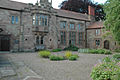
Monmouth Priory is a building that incorporates the remains of the monastic buildings attached to St Mary’s Priory Church. The priory was a Benedictine foundation of 1075, and parts of the medieval buildings remain. The buildings were substantially redeveloped in the nineteenth century for use as St Mary's National School, and now form a community centre.
11 St Mary’s Priory Church Monmouth P church.jpg II*18 - 19 C 51°48′48″N2°42′50″W / 51.8132°N 2.714°W / 51.8132; -2.714 (St Mary’s Church) St Mary's Priory Church, in Whitecross Street, is an Anglican church founded as a Benedictine priory in 1075. The current church dates mostly from the 18th and 19th centuries. It was designated a Grade II* listed building in 1952.
12 Monmouth County Gaol 12 Monmouth County Gaol HTsmall.jpg II1780s 51°49′01″N2°42′47″W / 51.817°N 2.713°W / 51.817; -2.713 (County Gaol) The County Gaol was Monmouthshire's main prison when it was opened in 1790. A castellated medieval fortress, it served as the county jail of Monmouthshire and criminals or those who fell foul of the authorities were hanged here until the 1850s and some 3,000 people viewed the last hanging. The jail covered an area of about an acre, with a chapel, infirmary, living quarters and a treadmill. It was closed in 1869.
13 Rolls Hall Monmouth library - geograph.org.uk - 1500836.jpg II1887 51°48′47″N2°42′40″W / 51.813°N 2.711°W / 51.813; -2.711 (Rolls Hall) The Rolls Hall, Whitecross Street, is a Victorian hall, now public library, donated to the town in celebration of Queen Victoria's Golden Jubilee by John Rolls, the future Lord Llangattock. It is a Grade II listed building as of 8 October 2005.
14 Judges' Lodgings Judges' Lodgings Monmouth.jpg II18c 51°48′47″N2°42′43″W / 51.81306°N 2.712°W / 51.81306; -2.712 (Judges' Lodgings) The Judges' Lodgings, located in Whitecross Street, is an eighteenth-century building, with earlier origins, on the edge of St James' Square. It has its origins as an early 16th-century town house, becoming the 'Labour in Vain' inn around 1756. It was in use as the Judges' Lodgings for the Monmouth Assizes before 1835, and as the Militia Officers' Mess in the 1870s.
15 The Dispensary 15 The Old Dispensary HTsmall.jpg na1860s? 51°48′47″N2°42′38″W / 51.8130°N 2.7106°W / 51.8130; -2.7106 (Dispensary) The Dispensary, Monmouth is a Georgian town house which is fairly typical of many town-centre houses in Monmouth, dating from the mid-18th century, but with early 19th-century additions. It stands in St James' Square, opposite the Catalpa Tree.
16 Monmouth Methodist Church 16 Monmouth Methodist Church HTsmall.jpg II*1837 51°48′43″N2°42′36″W / 51.812°N 2.710°W / 51.812; -2.710 (Methodist Church) 
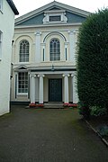
Monmouth Methodist Church is set well back from St James' Street between buildings. Designed by George Vaughan Maddox and built in 1837, it retains its original galleries, organ loft and sophisticated pulpit.
17 St Mary's Roman Catholic Church St Marys Roman Catholic Church, Monmouth..jpg II1793 51°48′44″N2°42′47″W / 51.812306°N 2.713°W / 51.812306; -2.713 (St Mary's R.C. Church) St Mary's Roman Catholic Church, in St Mary's Street near the centre of Monmouth, is the earliest post-Reformation Catholic public place of worship to be permitted in Wales. The church is a late Georgian Roman Catholic church with later Victorian additions by the Catholic convert architect Benjamin Bucknall. It is a Grade II listed building as of 15 August 1974.
18 Angel Hotel 18 The Angel Hotel HTsmall.jpg II17 C 51°48′46″N2°42′51″W / 51.8127°N 2.7142°W / 51.8127; -2.7142 (Angel Hotel) The Angel Hotel, Church Street, is a Grade II listed building. The building was in use as an inn in 1700 and closed in 1985, the longest period of continuous history of any public house in Monmouth. The building is of two storeys, with a roof of Welsh slate and a wooden Doric doorcase. During the late nineteenth century, the hotel was the headquarters of the Monmouth Branch of the Cyclists Touring Club
19 Savoy Theatre The Savoy Theatre, Monmouth - geograph.org.uk - 1070497.jpg II*19C 51°48′46″N2°42′52″W / 51.81284°N 2.7145°W / 51.81284; -2.7145 (Savoy Theatre) The Savoy Theatre is a theatre and cinema in a town of some 9,000 residents in south east Wales. It is a Grade II* listed building, which was refurbished in 1928 in traditional style, and is reputedly the oldest working theatre site in Wales. It has a capacity of 360 seats and is now run by a charitable trust.
20 The White Swan Inn White Swan Court, Monmouth.JPG II*rebuilt 1839 51°48′32″N2°43′23″W / 51.809°N 2.723°W / 51.809; -2.723 (White Swan Inn) The White Swan Inn, White Swan Court, Church Street, is an eighteenth-century former coaching inn. The building is of three storeys, with a prominent bay window on the ground floor, and faced with white stucco which dates from the early nineteenth century. There was an earlier inn, the Swan and Falcon, on this site from at least 1709.
21 Agincourt House Agincourt House, Monmouth - geograph.org.uk - 1304384.jpg II*17-19C 51°48′45″N2°42′54″W / 51.812472°N 2.715°W / 51.812472; -2.715 (Agincourt House) Agincourt House, No. 1 Agincourt Square is a notable early seventeenth-century half-timbered building. The building has been much restored, but the bargeboard over the gable onto Agincourt Square gives a date of 1624. The initials either side of the date are those of William Roberts.
22 Beaufort Arms Hotel 22 Beaufort Arms Ct Beaufort Hotel HTsmall.jpg II*1830s 51°48′43″N2°42′54″W / 51.812°N 2.715°W / 51.812; -2.715 (Beaufort Arms) The Beaufort Arms Hotel, Agincourt Square, is a former coaching inn dating from the early eighteenth century, though the frontage may have been modified by the prolific early Victorian architect George Vaughan Maddox in the 1830s. A stone cornice on the central block still carries the inscription "The Beaufort Arms". It is a Grade II* listed building as of 27 June 1952
23 Hyam's Mineral Water Works 23 Hyam's Mineral Works HTsmall.jpg na1866 51°48′40″N2°42′50″W / 51.811°N 2.714°W / 51.811; -2.714 (Hyam's Water Works) Hyam's Mineral Water Works is a nineteenth-century building at 23 Glendower Street. Formerly a mineral water works, it is currently used as residential apartments. This mineral water works for the manufacture of soda water, lemonade and ginger beer, was established in Glendower Street in 1866 by Thomas E. Hyam, a leading figure in nineteenth-century Monmouth.
24 The Nelson Garden 24 The Nelson Garden HTsmall.jpg II*nom.1802 51°48′40″N2°42′56″W / 51.811°N 2.7156°W / 51.811; -2.7156 (Nelson Garden) The Nelson Garden, on 13 Chippenhamgate Street, at the rear of No.18 Monnow Street is a nineteenth-century garden that was the scene of a tea party held to honour Lord Nelson in 1802. It is bounded on the south by the line of the medieval town wall through which it is entered via a short underground passageway.

Related Research Articles

<span class="mw-page-title-main">Monmouth</span> Town in Monmouthshire, Wales

Monmouth is a town and community in Wales. It is situated where the River Monnow joins the River Wye, two miles from the Wales–England border. Monmouth is 30 miles (50 km) northeast of Cardiff, and 113 miles (182 km) west of London. It is within the Monmouthshire local authority, and the parliamentary constituency of Monmouth. The population in the 2011 census was 10,508, rising from 8,877 in 2001. Monmouth is the historic county town of Monmouthshire although Abergavenny is now the county town.

<span class="mw-page-title-main">Offa's Dyke Path</span> Footpath in Wales and England

Offa's Dyke Path is a long-distance footpath loosely following the Wales–England border. Officially opened on 10 July 1971, by Lord Hunt, it is one of Britain's National Trails and draws walkers from throughout the world. About 60 miles (97 km) of the 177-mile (285 km) route either follows, or keeps close company with, the remnants of Offa's Dyke, an earthwork traditionally thought to have been constructed in the late 8th century on the orders of King Offa of Mercia.

<span class="mw-page-title-main">Monnow Bridge</span> Grade I listed building and bridge in Monmouth, south-east Wales

Monnow Bridge, in Monmouth, Wales, is the only remaining fortified river bridge in Great Britain with its gate tower standing on the bridge. Such bridge towers were common across Europe from medieval times, but many were destroyed due to urban expansion, diminishing defensive requirements and the increasing demands of traffic and trade. The historical and architectural importance of the bridge and its rarity are reflected in its status as a scheduled monument and a Grade I listed building. The bridge crosses the River Monnow 500 metres (1,600 ft) above its confluence with the River Wye.

<span class="mw-page-title-main">Blestium</span>

Blestium was a small fort and iron working centre in the Roman province of Britannia Superior, part of Roman Britain. It has been identified with the site of the later town of Monmouth in south east Wales, located adjoining the confluence of the River Monnow with the River Wye. A plaque on the local bank records its position.

<span class="mw-page-title-main">Monmouth Castle</span>

Monmouth Castle is a castle close to the centre of the town of Monmouth, the county town of Monmouthshire, on a hill above the River Monnow in south-east Wales.

<span class="mw-page-title-main">Shire Hall, Monmouth</span> Building in Monmouth, Wales

The Shire Hall, Monmouth, Wales, is a prominent building on Agincourt Square in the town centre. It was built in 1724, and was formerly the centre for the Assize Courts and Quarter Sessions for Monmouthshire. The building was also used as a market place. In 1839–40, the court was the location of the trial of the Chartist leader John Frost and others for high treason for their part in the Newport Rising.

<span class="mw-page-title-main">Church of St Thomas the Martyr, Monmouth</span> Church in Monmouthshire, Wales

The Church of St Thomas the Martyr at Overmonnow, Monmouth, south east Wales, is located beside the medieval Monnow Bridge across the River Monnow. At least part of the building dates from around 1180, and it has a fine 12th-century Norman chancel arch, though the exterior was largely rebuilt in the early 19th century. It is one of 24 buildings on the Monmouth Heritage Trail and is a Grade II* listed building.

<span class="mw-page-title-main">St Mary's Roman Catholic Church, Monmouth</span> Church in Monmouthshire, Wales

St Mary's Roman Catholic Church, in St Mary's Street near the centre of Monmouth, is the earliest post-Reformation Catholic public place of worship to be permitted in Wales. The church is a late Georgian Roman Catholic church with later Victorian additions by the Catholic convert architect Benjamin Bucknall. It has been designated as a Grade II listed building since 15 August 1974, and is one of 24 buildings on the Monmouth Heritage Trail.

<span class="mw-page-title-main">Robin Hood Inn, Monmouth</span> Public house in Monmouth, Wales

The Robin Hood Inn, Nos. 124 and 126, Monnow Street, Monmouth, Monmouthshire, Wales, is a public house of late medieval origins. It was Grade II* listed in 1952.

<span class="mw-page-title-main">Market Hall, Monmouth</span> Market Hall in Monmouth, Wales

The Market Hall, in Priory Street, Monmouth, Wales, is an early Victorian building by the prolific Monmouth architect George Vaughan Maddox. It was constructed in the years 1837–39 as the centrepiece of a redevelopment of part of Monmouth town centre. After being severely damaged by fire in 1963, it was partly rebuilt and was the home of Monmouth Museum from 1969 to 2021. At the rear of the building are original slaughterhouses, called The Shambles, opening onto the River Monnow. The building is Grade II listed as at 27 June 1952, and it is one of 24 buildings on the Monmouth Heritage Trail. The Shambles slaughterhouses are separately listed as Grade II*.

<span class="mw-page-title-main">Beaufort Arms Hotel, Monmouth</span> Building in Monmouth, Wales

The Beaufort Arms Hotel, in Agincourt Square in the town of Monmouth, south-east Wales is a former coaching inn dating from the early eighteenth century. The frontage was modified in the 1830s, possibly by the prolific early Victorian architect George Vaughan Maddox. A stone cornice on the central block carries the inscription "The Beaufort Arms". A Grade II* listed building, it features in the Monmouth Heritage Trail. In the 20th century, the building was converted to residential apartments.

<span class="mw-page-title-main">The Angel Hotel, Monmouth</span> Historic building in Wales

The Angel Hotel, Church Street, Monmouth, Monmouthshire, south-east Wales is a Grade II listed building. The building was in use as an inn in 1700 and closed in 1985, the longest period of continuous history of any public house in Monmouth. The building is of three storeys, with a roof of Welsh slate and a wooden Doric doorcase. During the late nineteenth century, the hotel was the headquarters of the Monmouth Branch of the Cyclists Touring Club. It is now a furniture shop, and one of 24 buildings on the Monmouth Heritage Trail.

<span class="mw-page-title-main">George Vaughan Maddox</span> 19th c. British architect and builder

George Vaughan Maddox was a nineteenth-century British architect and builder, whose work was undertaken principally in the town of Monmouth, Wales, and in the wider county. Working mainly in a Neo-Classical style, his extensive output made a significant contribution to the Monmouth townscape. The architectural historian John Newman considers that Monmouth owes to Maddox "its particular architectural flavour. For two decades from the mid-1820s he put up a sequence of public buildings and private houses in the town, in a style deft, cultured, and only occasionally unresolved." The Market Hall and 1-6 Priory Street are considered his "most important projects".

<span class="mw-page-title-main">Church Street, Monmouth</span>

Church Street is a pedestrianised street in the centre of Monmouth, Wales. It contains a variety of independent shops, restaurants, commercial art galleries, and the Savoy Theatre. Until the 1830s, when Priory Street was built to bypass it, it was the main thoroughfare into the centre of Monmouth from the north-east, linking the market and the parish church. It was at one time the centre of the town's butchery trade and was known as Butcher's Row.

<span class="mw-page-title-main">Monmouth town walls and defences</span>

The Monmouth town walls and defences comprise the defensive system of town walls and gates built in Monmouth, Wales between 1297 and the early part of the following century. Wye Bridge Gate, East Gate, Monk's Gate, and Monnow Bridge Gate were access points to the town. West Gate, across Monnow Street, also provided access. Only the Monnow Bridge Gatehouse survives intact, albeit in a substantially modified version from the original.

<span class="mw-page-title-main">Whitecross Street, Monmouth</span>

Whitecross Street is a historic street in the town centre of Monmouth, Monmouthshire, Wales. It was in existence by the 15th century, and appears as Whit crose on the 1610 map of the town by cartographer John Speed. It runs in an east-west direction, between Church Street and St James Square. It has been suggested that the street takes its name from a plague cross. Whitecross Street is lined with numerous listed buildings.

<span class="mw-page-title-main">Glendower Street, Monmouth</span>

Glendower Street is a historic street in the town centre of Monmouth, Monmouthshire, Wales. It extends to the southeast from the intersection of Agincourt Street and St John's Street, within the medieval town walls. Glendower Street is lined with numerous listed buildings, including one of the 24 blue plaque buildings on the Monmouth Heritage Trail.

<span class="mw-page-title-main">Wye Bridge Ward, Monmouth</span>

Wye Bridge Ward was one of four wards in the town of Monmouth, Monmouthshire, Wales. Streets in the ward included St Mary's Street, Almshouse Street, St James Street, St James Square, Whitecross Street and Monk Street. The ward existed as a division of the town by the early seventeenth century, and continued into the twentieth century.

<span class="mw-page-title-main">Grade I listed buildings in Monmouthshire</span>

Monmouthshire is a county and principal area of Wales. It borders Torfaen and Newport to the west; Herefordshire and Gloucestershire to the east; and Powys to the north. The largest town is Abergavenny, with the other major towns being Chepstow, Monmouth, and Usk. The county is 850 km2 in extent, with a population of 95,200 as of 2020. The present county was formed under the Local Government (Wales) Act 1994, which came into effect in 1996, and comprises some sixty percent of the historic county. Between 1974 and 1996, the county was known by the ancient title of Gwent, recalling the medieval Welsh kingdom. In his essay on local government in the fifth and final volume of the Gwent County History, Robert McCloy suggests that the governance of "no county in the United Kingdom in the twentieth century was so transformed as that of Monmouthshire".

<span class="mw-page-title-main">Grade II* listed buildings in Monmouthshire</span> List of buildings in principal area of Wales

Monmouthshire is a county of Wales. It borders Torfaen and Newport to the west; Herefordshire and Gloucestershire to the east; and Powys to the north. The largest town is Abergavenny, with the other major towns being Chepstow, Monmouth, and Usk. The county is 850 km2 in extent, with a population of 95,200 as of 2020. The present county was formed under the Local Government (Wales) Act 1994, which came into effect in 1996, and comprises some sixty percent of the historic county. Between 1974 and 1996, the county was known by the ancient title of Gwent, recalling the medieval Welsh kingdom. In his essay on local government in the fifth and final volume of the Gwent County History, Robert McCloy suggests that the governance of "no county in the United Kingdom in the twentieth century was so transformed as that of Monmouthshire".

References

  1. 1 2 Blue Plaque Trail [ permanent dead link ], VisitWyeValley.com, accessed January 2012
  2. 1 2 Listed Buildings, English Heritage, 2010, retrieved 6 April 2012
  3. Wikipedia project to cover life in Monmouth, BBC News, 30 December 2011