Monmouth is a town and community in Wales. It is situated where the River Monnow joins the River Wye, 2 miles (3.2 km) from the Wales–England border. Monmouth is 30 miles (48 km) northeast of Cardiff, and 113 miles (182 km) west of London. It is within the Monmouthshire local authority, and the parliamentary constituency of Monmouth. The population in the 2011 census was 10,508, rising from 8,877 in 2001. Monmouth is the historic county town of Monmouthshire although Abergavenny is now the county town.

Chepstow is a town and community in Monmouthshire, Wales, adjoining the border with Gloucestershire, England. It is located on the tidal River Wye, about 2 miles (3.2 km) above its confluence with the River Severn, and adjoining the western end of the Severn Bridge. It is the easternmost settlement in Wales, situated 16 miles (26 km) east of Newport, 28 miles (45 km) east-northeast of Cardiff, 18 miles (29 km) northwest of Bristol and 110 miles (180 km) west of London.

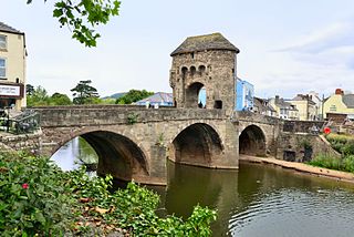
Monnow Bridge, in Monmouth, Wales, is the only remaining fortified river bridge in Great Britain with its gate tower standing on the bridge. Such bridge towers were common across Europe from medieval times, but many were destroyed due to urban expansion, diminishing defensive requirements and the increasing demands of traffic and trade. The historical and architectural importance of the bridge and its rarity are reflected in its status as a scheduled monument and a Grade I listed building. The bridge crosses the River Monnow 500 metres (1,600 ft) above its confluence with the River Wye.
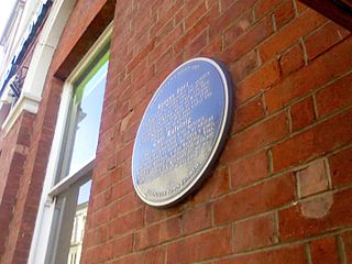
Blestium was a small fort and iron working centre in the Roman province of Britannia Superior, part of Roman Britain. It has been identified with the site of the later town of Monmouth in south east Wales, located adjoining the confluence of the River Monnow with the River Wye. A plaque on the local bank records its position.
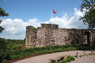
Monmouth Castle is a castle close to the centre of the town of Monmouth, the county town of Monmouthshire, on a hill above the River Monnow in south east Wales.

The Shire Hall in Agincourt Square, Monmouth, Wales, is a prominent Grade I listed building in the town centre. It was built in 1724, and was formerly the centre for the Assize Courts and Quarter Sessions for Monmouthshire. In 1839–40, the court was the location of the trial of the Chartist leader John Frost and others for high treason for their part in the Newport Rising. The building was also used as a market place. The Shire Hall is owned by Monmouthshire County Council and has audiovisual guides for visitors to Courtroom 1. It is currently used as a Tourist Information Centre and as the offices for Monmouth Town Council, and is open to the public in part.

The Church of St Thomas the Martyr at Overmonnow, Monmouth, south east Wales, is located beside the medieval Monnow Bridge across the River Monnow. At least part of the building dates from around 1180, and it has a fine 12th-century Norman chancel arch, though the exterior was largely rebuilt in the early 19th century. It is one of 24 buildings on the Monmouth Heritage Trail and is a Grade II* listed building.

The Battle of Monmouth took place on 25 November 1233, the feast day of St Catherine, between forces loyal to Henry III, King of England, and those of Richard Marshal, Earl of Pembroke and Lord Marshal of England, who had formed an alliance with the Welsh prince Llywelyn ap Iorwerth and his supporter Owain ap Gruffydd, a grandson of Rhys of Deheubarth.

The Wye Bridge in Monmouth is a bridge across the River Wye. The A466 passes over it and immediately meets the A40 at its western end. The bridge is a grade II listed building. The total span of the bridge is 71 metres (233 ft).
Withenoc or Guihenoc de La Boussac was a nobleman and monk of Breton origin, who was lord of Monmouth between 1075 and 1082 and was responsible for founding the Priory at Monmouth.

Church Street is a pedestrianised street in the centre of Monmouth, Wales. It contains a variety of independent shops, restaurants, commercial art galleries, and the Savoy Theatre. Until the 1830s, when Priory Street was built to bypass it, it was the main thoroughfare into the centre of Monmouth from the north-east, linking the market and the parish church. It was at one time the centre of the town's butchery trade and was known as Butcher's Row.

Overmonnow is a suburb of the town of Monmouth, in Wales, which is located to the west of the River Monnow and the Monnow Bridge. It developed in the Middle Ages, when it was protected by a defensive ditch, the Clawdd-du or "Black Dyke", the remains of which are now protected as an ancient monument. In later centuries the area became known as "Little Monmouth" or "Cappers' Town".

The Cross is situated in St Thomas' Square, Overmonnow, Monmouth, Wales, in the middle of a roundabout opposite the Church of St Thomas the Martyr and the western end of the Monnow Bridge. Originally mediaeval, and also known as Overmonnow Cross, the cross was reconstructed in 1888 and has been classed as a Grade II listed structure since 15 August 1974.

Vauxhall Fields, also known as Vauxhall Meadows, are water meadows to the northwest of Monmouth town centre, Wales. The River Monnow borders the meadows on two sides. The meadows have generally remained free of development. The area has been prone to flooding on many occasions over the years.
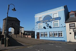
The Gatehouse, also known as The Gate House, is a public house located next to Monnow Bridge in Monmouth, Wales. The pub was known as the Barley Mow until it changed its name in 1993. It is the only public house in Monmouth located beside a river. The pub has a restaurant area, seated balcony and a function room.

Monnow Street is the main shopping street of Monmouth, south east Wales. It runs for about 500 yards in a south-westerly direction from Agincourt Square to the Monnow Bridge, which crosses the River Monnow.
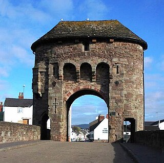
The Monmouth town walls and defences comprise the defensive system of town walls and gates built in Monmouth, Wales between 1297 and the early part of the following century. Wye Bridge Gate, East Gate, Monk's Gate, and Monnow Bridge Gate were access points to the town. West Gate, across Monnow Street, also provided access. Only the Monnow Bridge Gatehouse survives intact, albeit in a substantially modified version from the original.

1–6 Priory Street in Monmouth, Wales, is a row of six shop houses designed by the architect George Vaughan Maddox and constructed c. 1837. They form part of Maddox's redevelopment of the centre of Monmouth and stand opposite his Market Hall. The architectural historian John Newman has written that Maddox's work "gives Monmouth its particular architectural flavour," and considers Priory Street to be "his greatest work."

The Inglis Bridge, Monmouth, Wales crosses the River Monnow linking Vauxhall Fields and the suburb of Osbaston. Designed by, and named after, Charles Inglis, the bridge was constructed in 1931 and refurbished in 1988. It is a Mark II model of an Inglis bridge, and the only known example in Britain of such a bridge still in public use. Access is now limited to pedestrians, vehicular use being prohibited in 2018 on safety grounds. The bridge is a Grade II listed structure.

Perth-hir House, Rockfield, Monmouthshire, Wales, was a major residence of the Herbert family. It stood at a bend of the River Monnow, to the north-west of the village. At its height in the 16th century, the mansion, entered by two drawbridges over a moat, comprised a great hall and a number of secondary structures. Subsequently in the ownership of the Powells, and then the Lorimers, the house became a centre of Catholic recusancy following the English Reformation. By the 19th century, the house had declined to the status of a farmhouse and it was largely demolished in around 1830. Its ruins, and the site which contains considerable remnants of a Tudor garden, are a scheduled monument.


