
The Shire Hall, Monmouth, Wales, is a prominent building on Agincourt Square in the town centre. It was built in 1724, and was formerly the centre for the assize courts and quarter sessions for Monmouthshire. The building was also used as a market place. In 1839–40, the court was the location of the trial of the Chartist leader John Frost and others for high treason for their part in the Newport Rising.
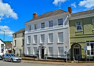
The Dispensary is a Georgian town house which is fairly typical of many town-centre houses in Monmouth, Wales, dating from the mid 18th century, but with early 19th-century additions. It stands in St James Square, opposite the Catalpa tree. The building was listed at Grade II on 27 June 1952.

The Robin Hood Inn, Nos. 124 and 126, Monnow Street, Monmouth, Monmouthshire, Wales, is a public house of late medieval origins. It was Grade II* listed in 1952.

The Mayor of Monmouth is an elected position given to a town councillor in Monmouth in Wales. The position dates back about 750 years.

The Cross is situated in St Thomas' Square, Overmonnow, Monmouth, Wales, in the middle of a roundabout opposite the Church of St Thomas the Martyr and the western end of the Monnow Bridge. Originally mediaeval, and also known as Overmonnow Cross, the cross was reconstructed in 1888 and has been classed as a Grade II listed structure since 15 August 1974.

Vauxhall Fields, also known as Vauxhall Meadows, are water meadows to the northwest of Monmouth town centre, Wales. The River Monnow borders the meadows on two sides. The meadows have generally remained free of development. The area has been prone to flooding on many occasions over the years.

Chippenham Mead is a town green in Monmouth, Wales. The meadow is registered common land and is situated between Blestium Street and the River Wye, intersected by the A40(T) Monmouth bypass. Within the park lies a sports area called Chippenham Sports Ground. The meadow is listed at Grade II on the Cadw/ICOMOS Register of Parks and Gardens of Special Historic Interest in Wales.

The Queens Head is a public house located at 1, St James Street, Monmouth, Wales. It has also known as The Queens Head Hotel and formerly Queens Head Inn.

Monmouth Fire and Rescue Station is located on the Rockfield Road, Monmouth, Wales. The station looks after Monmouth and its surrounding area, and is part of the South Wales Fire and Rescue Service. There is currently one Retained Watch.

Wyastone Leys is a country house estate and Grade II listed building situated near Ganarew, in the southwestern corner of The Doward, in Herefordshire, England. The house and estate has also been known as The Leys or Lays House. It is located 2 miles (3.2 km) from Monmouth and 8 miles (13 km) from Ross-on-Wye. The house is in close proximity to the River Wye and less than 50 metres (160 ft) from the county boundary between Herefordshire and Monmouthshire.
The Clawdd-du, also known in historical records as the Black Dyke, Black Ditch or Clawthy, is a mediaeval linear defensive earthwork or moat, constructed as protection for the faubourg of Overmonnow, on the opposite side of the River Monnow from the town and castle of Monmouth, Wales.

The Punch House is a public house and hotel located at Agincourt Square, Monmouth, Wales.

Agincourt Square is an open space in the centre of Monmouth, Wales, in front of the Shire Hall. The area has been used for public functions and markets over the centuries.

Osbaston is a suburb of Monmouth, Wales, located less than 1 mile (1.6 km) north of the town centre. It was the site of one of the first public electricity generating stations in Britain, using water power from the River Monnow.
There are a number of war memorials in Monmouth, Wales.

The Three Horseshoes used to be a public house in Drybridge Street in the Overmonnow area of Monmouth, Wales. The pub has also been used as an Inn and also known as The Three Horse Shoes Inn. The building has been a Grade II Listed building since 15 August 1974. Appears of 19th century but of C17th origin. 2 storeys, roughcast as stone with a hooded doorway
Priory House is a Grade II Listed building in Monmouth, Wales.
The Cottage Hospital was a community hospital on the Hereford Road in Monmouth, Wales.

Monk Street is an historic street in the town of Monmouth, Monmouthshire, Wales. A portion of it was in existence by the 14th century, and appears on the 1610 map of the town by cartographer John Speed. It runs in a north-south direction, extending northward from its intersection with Whitecross Street. The name of the street relates to the nearby Priory, as well as the gate which was originally on this road and provided part of the town's defences, Monk's Gate. Monk Street is lined with numerous listed buildings.

Kingsley House and Hendre House are a pair of 19th-century, semi-detached houses on the North Parade section of Monk Street in Monmouth, Monmouthshire, Wales. The grade II listed houses were designed by noted Monmouth architect and builder George Vaughan Maddox, who also designed at least two of the twenty-four blue plaque buildings on the Monmouth Heritage Trail, including the Market Hall and the Monmouth Methodist Church. Hendre House should be distinguished from The Hendre, the estate of the Rolls family.

