
A castle is a type of fortified structure built during the Middle Ages predominantly by the nobility or royalty and by military orders. Scholars usually consider a castle to be the private fortified residence of a lord or noble. This is distinct from a mansion, palace and villa, whose main purpose was exclusively for pleasance and are not primarily fortresses but may be fortified. Use of the term has varied over time and, sometimes, has also been applied to structures such as hill forts and 19th- and 20th-century homes built to resemble castles. Over the Middle Ages, when genuine castles were built, they took on a great many forms with many different features, although some, such as curtain walls, arrowslits, and portcullises, were commonplace.

Castles have played an important military, economic and social role in Great Britain and Ireland since their introduction following the Norman invasion of England in 1066. Although a small number of castles had been built in England in the 1050s, the Normans began to build motte and bailey and ringwork castles in large numbers to control their newly occupied territories in England and the Welsh Marches. During the 12th century the Normans began to build more castles in stone – with characteristic square keep – that played both military and political roles. Royal castles were used to control key towns and the economically important forests, while baronial castles were used by the Norman lords to control their widespread estates. David I invited Anglo-Norman lords into Scotland in the early 12th century to help him colonise and control areas of his kingdom such as Galloway; the new lords brought castle technologies with them and wooden castles began to be established over the south of the kingdom. Following the Norman invasion of Ireland in the 1170s, under Henry II, castles were established there too.
A motte-and-bailey castle is a European fortification with a wooden or stone keep situated on a raised area of ground called a motte, accompanied by a walled courtyard, or bailey, surrounded by a protective ditch and palisade. Relatively easy to build with unskilled labour, but still militarily formidable, these castles were built across northern Europe from the 10th century onwards, spreading from Normandy and Anjou in France, into the Holy Roman Empire, as well as the Low Countries it controlled, in the 11th century, when these castles were popularized in the area that became the Netherlands. The Normans introduced the design into England and Wales. Motte-and-bailey castles were adopted in Scotland, Ireland, and Denmark in the 12th and 13th centuries. By the end of the 13th century, the design was largely superseded by alternative forms of fortification, but the earthworks remain a prominent feature in many countries.

Okehampton Castle is a medieval motte and bailey castle in Devon, England. It was built between 1068 and 1086 by Baldwin FitzGilbert following a revolt in Devon against Norman rule, and formed the centre of the Honour of Okehampton, guarding a crossing point across the West Okement River. It continued in use as a fortification until the late 13th century, when its owners, the de Courtenays, became the Earls of Devon. With their new wealth, they redeveloped the castle as a luxurious hunting lodge, building a new deer park that stretched out south from the castle, and constructing fashionable lodgings that exploited the views across the landscape. The de Courtenays prospered and the castle was further expanded to accommodate their growing household.
Castle Acre Castle and town walls are a set of ruined medieval defences built in the village of Castle Acre, Norfolk. The castle was built soon after the Norman Conquest by William de Warenne, the Earl of Surrey, at the intersection of the River Nar and the Peddars Way. William constructed a motte-and-bailey castle during the 1070s, protected by large earthwork ramparts, with a large country house in the centre of the motte. Soon after, a small community of Cluniac monks were given the castle's chapel in the outer bailey; under William, the second earl, the order was given land and estates to establish Castle Acre Priory alongside the castle. A deer park was created nearby for hunting.

The Castles and Town Walls of King Edward in Gwynedd is a UNESCO-designated World Heritage Site located in Gwynedd, Wales. It includes the castles of Beaumaris and Harlech and the castles and town walls of Caernarfon and Conwy. UNESCO considers the sites to be the "finest examples of late 13th century and early 14th century military architecture in Europe".
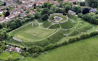
Thetford Castle is a medieval motte and bailey castle in the market town of Thetford in the Breckland area of Norfolk, England. The first castle in Thetford, a probable 11th-century Norman ringwork called Red Castle, was replaced in the 12th century by a much larger motte and bailey castle on the other side of the town. This new castle was largely destroyed in 1173 by Henry II, although the huge motte, the second largest man-made mound in England, remained intact. The motte, recognised as a scheduled monument, now forms part of a local park, and the remains are known variously as Castle Hill, Castle Mound and Military Parade.

Conwy's town walls are a medieval defensive structure around the town of Conwy in Wales. The walls were constructed between 1283 and 1287 after the foundation of Conwy by Edward I, and were designed to form an integrated system of defence alongside Conwy Castle. The walls are 1.3 km (0.81 mi) long and include 21 towers and three gatehouses. The project was completed using large quantities of labourers brought in from England; the cost of building the castle and walls together came to around £15,000, a huge sum for the period. The walls were slightly damaged during the rebellion of Owain Glyndŵr in 1401, but political changes in the 16th century reduced the need to maintain such defences around the town. The fortifications were treated sympathetically during the development of the road and railway systems in Conwy during the 19th century and survived largely intact into the modern period. Today the walls form part of the UNESCO World Heritage Site administered by Cadw. Historians Oliver Creighton and Robert Higham describe the defences as "one of the most impressive walled circuits" in Europe.

Caernarfon's town walls are a medieval defensive structure around the town of Caernarfon in North Wales. The walls were constructed between 1283 and 1292 after the foundation of Caernarfon by Edward I, alongside the adjacent castle. The walls are 734 m (2,408 ft) long and include eight towers and two medieval gatehouses. The project was completed using large numbers of labourers brought in from England; the cost of building the walls came to around £3,500, a large sum for the period. The walls were significantly damaged during the rebellion of Madog ap Llywelyn in 1294, and had to be repaired at considerable expense. Political changes in the 16th century reduced the need to maintain such defences around the town. Today the walls form part of the UNESCO World Heritage Site administered by Cadw. Archaeologists Oliver Creighton and Robert Higham describe the defences as "a remarkably intact walled circuit".
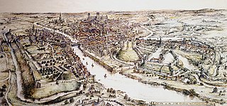
Worcester's city walls are a sequence of defensive structures built around the city of Worcester in England between the 1st and 17th centuries. The first walls to be built around Worcester were constructed by the Romans. These early walls lasted beyond the fall of the Empire, and the defences encouraged several early Christian foundations to establish themselves in Worcester during the troubled 6th and 7th centuries. The Anglo-Saxons expanded Worcester in the 890s, forming a new walled, planned city, called a burh. The burh utilised the southern stretches of the old Roman walls, but pushed further north to enclose a much larger area. The Anglo-Saxon city walls were maintained by a share of taxes on a local market and streets, in an agreement reinforced by a royal charter.
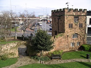
Coventry's city walls are a sequence of defensive structures built around the city of Coventry in England.

Bath's city walls were a sequence of defensive structures built around the city of Bath in England. Roman in origin, then restored by the Anglo-Saxons, and later strengthened in the High medieval period, the walls formed a complete circuit, covering the historic core of the modern city, an area of approximately 23 acres (9.3 ha) including the Roman Baths and medieval Bath Abbey. In the mid 18th century most of the town walls and gatehouses were demolished to accommodate the Georgian development of the town. However, the line of the walls can still be traced in the town's street layout.

Alnwick's town walls are a 15th-century defensive structure built around the town of Alnwick in England.

Beaumaris's town walls were a fifteenth-century defensive structure built around the town of Beaumaris in Wales.

Berwick's town walls are a sequence of defensive structures built around the town of Berwick-upon-Tweed in England.

Beverley's town walls are a sequence of defensive structures built around the town of Beverley in the East Riding of Yorkshire, England.

Southampton's town walls are a sequence of defensive structures built around the town in southern England. Although earlier Roman and Anglo-Saxon settlements around Southampton had been fortified with walls or ditches, the later walls originate with the move of the town to the current site in the 10th century. This new town was defended by banks, ditches and the natural curve of the river and coastline. The Normans built a castle in Southampton but made no attempts to improve the wider defences of the town until the early 13th century, when Southampton's growing prosperity as a trading centre and conflict with France encouraged the construction of a number of gatehouses and stone walls to the north and east sides of the settlement.
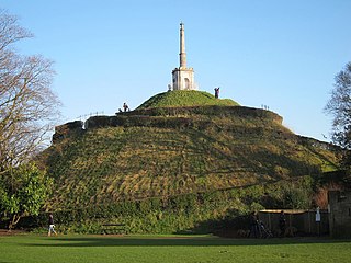
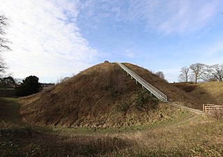
The Dane John Mound, also known as the Dane John Gardens, is a former Roman cemetery in the city of Canterbury, Kent. It was converted into a motte-and-bailey castle in the 11th century, and turned into a civic park between 1790 and 1803.

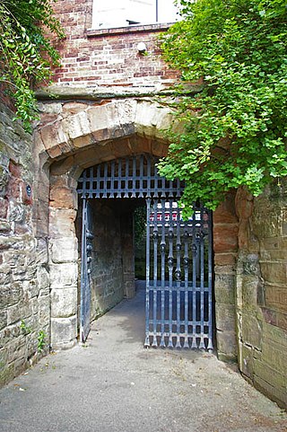
Canterbury city walls are a sequence of defensive walls built around the city of Canterbury in Kent, England. The first city walls were built by the Romans, probably between 270 and 280 AD. These walls were constructed from stone on top of an earth bank, and protected by a ditch and wall towers. At least five gates were placed into the walls, linked to the network of Roman roads across the region. With the collapse of Roman Britain, Canterbury went into decline but the walls remained, and may have influenced the decision of Augustine to settle in the city at the end of the 6th century. The Anglo-Saxons retained the defensive walls, building chapels over most of the gates and using them to defend Canterbury against Viking incursions.

