Related Research Articles

Aberdaron is a community, electoral ward and former fishing village at the western tip of the Llŷn Peninsula in the Welsh county of Gwynedd. It lies 14.8 miles (23.8 km) west of Pwllheli and 33.5 miles (53.9 km) south west of Caernarfon, and has a population of 965. The community includes Bardsey Island, the coastal area around Porthor, and the villages of Anelog, Llanfaelrhys, Penycaerau, Rhoshirwaun, Rhydlios, Uwchmynydd and Y Rhiw. It covers an area of just under 50 square kilometres.

Kiama is a coastal town 120 kilometres south of Sydney in the Illawarra. One of the main tourist attractions is the Kiama Blowhole. Kiama features several popular surfing beaches and caravan parks, and numerous alfresco cafes and restaurants. Its proximity to the south of Sydney makes it an attractive destination for many day-trippers and weekenders.
Penmaenmawr is a town and community in Conwy County Borough, Wales, which was formerly in the parish of Dwygyfylchi and the traditional county of Caernarfonshire. It is on the North Wales coast between Conwy and Llanfairfechan and was an important quarrying town, though quarrying is no longer a major employer. The population of the community was 4,353 in 2011, including Dwygyfylchi and Capelulo. The town itself having a population of 2,868 (2011).

The Preseli Hills or, as they are known locally and historically, Preseli Mountains is a range of hills in north Pembrokeshire, west Wales, mostly within the Pembrokeshire Coast National Park.

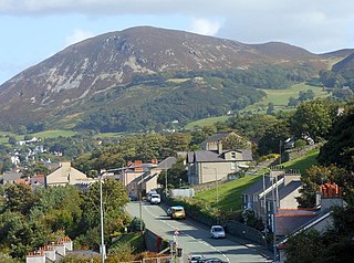
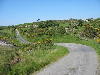
Llanbedrog is a village and community on the Llŷn peninsula of Gwynedd in Wales. It is situated on the south side of the peninsula on the A499 between Pwllheli and Abersoch. Formerly in the county of Caernarfonshire, it had a population of 1,020 in 2001, reducing slightly to 1,002 at the 2011 Census.

A commote was a secular division of land in Medieval Wales. The word derives from the prefix cym- and the noun bod. The English word "commote" is derived from the Middle Welsh cymwt.

The Nantlle Valley is an area in Gwynedd, North Wales, characterised by its numerous small settlements.

Llysfaen is a village and community in Conwy County Borough overlooking the north coast of Wales, and situated on the hill Mynydd Marian. For local government purposes, it is also a ward. The community includes the Peulwys estate of Old Colwyn.
Trefor is a village on the north coast of the Llŷn Peninsula in Gwynedd, Wales. With nearby Llanaelhaearn it makes up Llanaelhaearn community, which has a combined population of 1,117. Trefor is the larger of the two settlements, with a population of 814 as of 2011 census. It is in the historic county of Caernarfonshire.
Dulas Bay is a small bay on the north east coast of Anglesey, north Wales, forming the boundary between Llaneilian and Moelfre communities. The bay is bordered by three beaches.

Mynydd-y-Garreg or Mynyddygarreg is a village in the county of Carmarthenshire, West Wales. It borders the historic town of Kidwelly.

The Pwllheli and Llanbedrog Tramway was a 3 ft narrow gauge horse tramway on the coast of the Llŷn Peninsula in North West Wales, UK. It was originally constructed to convey building stone from Carreg-y-Defaid to Pwllheli's West End, with a second element to run between Pwllheli town centre and the West End resort on the seafront. The two were later connected, and extended to Llanbedrog in July 1897. The tramway was one of many developed by Solomon Andrews.

Nant Gwrtheyrn is a Welsh Language and Heritage Centre, located near the village of Llithfaen on the northern coast of the Llŷn Peninsula, Gwynedd, in northwest Wales.

Penwyllt is a hamlet located in the upper Swansea Valley in Powys, Wales.
Stepper Point is a headland on the Atlantic coast in north Cornwall, England, United Kingdom. It is at grid reference SW911781. Stepper Point and Pentire Point stand at either side of the mouth of the River Camel; Stepper to the south-west, Pentire to the north-east.
Llanfechell is a village in Anglesey, Wales. It is the largest of several small villages and dispersed settlements that make up Mechell Community Council area. It is 11 miles (18 km) east of Holyhead, and 5.6 miles (9 km) west of Amlwch, in the north of the island.

Tout Quarry, now known as Tout Quarry Sculpture Park and Nature Reserve, is a sculpture park and nature reserve based within a disused quarry on the Isle of Portland, Dorset, England. It is located within the north-west corner of Tophill. The sculpture park has existed since 1983, while the site also become a nature reserve around 2004. To date, the quarry displays a collection of various carvings and works in Portland stone.

St Brides Major is a community on the western edge of the Vale of Glamorgan, South Wales. Its largest settlement is the village of St Brides Major, and also includes the villages of Ogmore-by-Sea and Southerndown, and the hamlets of Ogmore Village, Castle-upon-Alun, Heol-y-Mynydd, Norton and Pont-yr-Brown It is notable for coastal geology and scenery, limestone downlands and fossilised primitive mammals, sea cliffs and beaches, two Iron Age hillforts, three medieval castle sites,, two stepping stone river crossings and a clapper bridge. Three long distance paths cross the community. It is the western limit of the Vale of Glamorgan Heritage Coast, and has a visitor centre and tourist facilities.
Porth Neigwl, also known in English as "Hell's Mouth", is a broad bay, about 3 miles (5 km) wide, on the south coast of the Llŷn Peninsula in North Wales.
Mechell is a community in the north of the Isle of Anglesey, Wales. Llanfechell is the largest village within the community area. Tregele, Llanfflewyn, Mynydd Mechell, Bodewryd, Rhosbeirio and Carreglefn have a more dispersed settlement pattern. The antiquity of these settlements is shown by the presence of 6 medieval churches and some 16 more ancient sites dating back into prehistory.
References
- ↑ "Llanbedrog Information - Headland and Foel Felin Wynt (Jampot)". Llanbedrog.info. Retrieved 7 February 2015.