
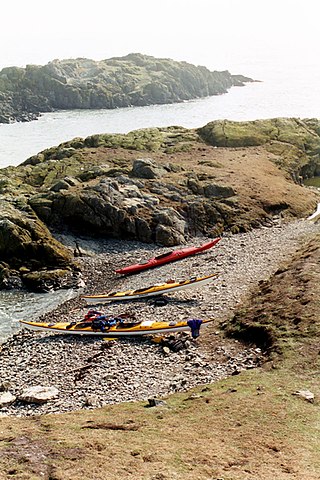
Din Lligwy hut circle is an ancient village site near the east coast of Anglesey, close to the village of Moelfre, North Wales.
The Skerries, coming from the Old Norse word sker, are a group of sparsely vegetated rocky islets (skerries), with a total area of about 17 hectares lying 3 kilometres (1.9 mi) offshore from Carmel Head at the northwest corner of Anglesey, Wales. The islands are important as a breeding site for seabirds, and they attract divers, who come to visit the numerous shipwrecks. The Skerries Lighthouse sits atop the highest point in the islands.

Fedw Fawr is an area on the east coast of Anglesey, North Wales, situated just under four miles north of Beaumaris. It is part of the Arfordir Gogleddol Penmon Site of Special Scientific Interest and is managed by the National Trust. The site covers 20 hectares most of which is made up of peaty gley soil.
Ynys Feurig, Cemlyn Bay and The Skerries Special Protection Area, also known as the (North) Anglesey tern colonies, is a Special Protection Area covering three sites in Anglesey, North Wales which support breeding terns:

Prehistoric Wales in terms of human settlements covers the period from about 230,000 years ago, the date attributed to the earliest human remains found in what is now Wales, to the year AD 48 when the Roman army began a military campaign against one of the Welsh tribes. Traditionally, historians have believed that successive waves of immigrants brought different cultures into the area, largely replacing the previous inhabitants, with the last wave of immigrants being the Celts. However, studies of population genetics now suggest that this may not be true, and that immigration was on a smaller scale.
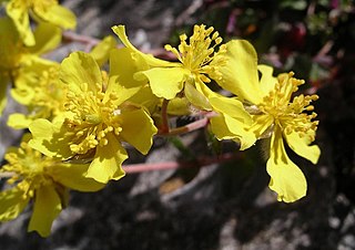
Helianthemum oelandicum, commonly called hoary rockrose, is a low growing plant confined to rocky dry calcareous areas especially close to the sea.

Penrhos Country Park is a country park near Holyhead, on the island of Anglesey in Wales, United Kingdom. The park attracts approximately 100,000 visitors each year. It was opened in 1971 on the former Penrhos estate which was formerly owned by the Stanley family and at the time of opening the Anglesey Aluminium company.
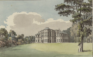
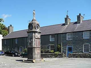
Baron Hill is a country estate in Beaumaris, Anglesey, Wales. The ruined Baron Hill House and the associated Baron Hill Park were established in 1618 by Sir Richard Bulkeley as the family seat of the influential Bulkeley family. Parts of the park are a site of special scientific interest.

Lligwy Burial Chamber is a Neolithic burial chamber in Lligwy, near the east coast of Anglesey, Wales, United Kingdom. It consists of a circle of upright stones, made into a low chamber by a very large roof slab estimated at 25 tonnes. Excavation in 1909 found the remains of some 15 to 30 people, and pottery suggesting a late Neolithic date. Close to the village of Moelfre, the site is within a few metres of the road, where there is room to leave a single car for short periods.

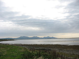
The Isle of Anglesey is a county off the north-west coast of Wales. It is named after the island of Anglesey, which makes up 94% of its area, but also includes Holy Island and some islets and skerries. The county borders Gwynedd across the Menai Strait to the southeast, and is otherwise surrounded by the Irish Sea. Holyhead is the largest town, and the administrative centre is Llangefni. The county is part of the preserved county of Gwynedd.
Foryd Bay, or Y Foryd, is a tidal bay in Gwynedd, Wales. It is located at the south-western end of the Menai Strait, about two miles south-west of Caernarfon. Several rivers flow into the bay and there are large areas of mudflats and salt marsh. A shingle spit partly blocks the mouth of the bay. At the north-western end is Fort Belan, built during the 18th century.
Dindaethwy was in medieval times one of two commotes of the cantref of Rhosyr, in the south-east of the Isle of Anglesey. It was between the Menai Strait and Conwy Bay, and the Irish Sea and Red Wharf Bay.

Llanfihangel Din Sylwy is a small, coastal (former) parish in the commote of Dindaethwy in north-east Anglesey, three miles north-northwest of Beaumaris.

The Roman conquest of Anglesey refers to two separate invasions of Anglesey in North West Wales that occurred during the early decades of the Roman conquest of Britain in the 1st century CE. The first invasion of North Wales began after the Romans had subjugated much of southern Britain. It was led by the Provincial governor of Britannia, Suetonius Paulinus, who led a successful assault on the island in 60–61 CE, but had to withdraw because of the Boudican revolt. In 77 CE, Gnaeus Julius Agricola's thorough subjugation of the island left it under Roman rule until the end of Roman rule in Britain in the early 5th century CE. The invasions occurred because Anglesey, which was recorded in Latin as Mona was a place of resistance to Roman rule because it was an important centre for the Celtic Druids and their religious practices.

Bryn Euryn is a hill which is a Site of Special Scientific Interest in Conwy County Borough, Wales. There is a trig point at the summit. It lies above the seaside town of Rhos-on-Sea and village of Mochdre, Conwy. It is 131 metres above sea level, and is listed as a HuMP. At the bottom of the hill are the remains of Llys Euryn.
Llanfechell is a village in Anglesey, Wales. It is the largest of several small villages and dispersed settlements that make up Mechell Community Council area. It is 11 miles (18 km) east of Holyhead, and 5.6 miles (9 km) west of Amlwch, in the north of the island.
Glannau Rhoscolyn is a Site of Special Scientific Interest in Anglesey, North Wales, and extends along the west coast of Holy Island, Anglesey for approximately 6.5 km (4.0 mi). It has been designated as a Site of Special Scientific Interest since January 1961 in an attempt to protect its fragile biological and geological elements. The site has an area of 145.49 hectares and is managed by Natural Resources Wales.

Castell Mawr is a large limestone rock that dominates the western shore of Red Wharf Bay in Anglesey, north Wales. It was probably once the site of an Iron Age fort, but today the rock is a protected refuge for nesting seabirds.

Parciau hill fort is a hill fort on the Welsh island of Anglesey. It stands on the summit of Bryn Ddiôl, whose name means "trackless hill".
