Hoarstones

Last updated

Hoarstones
Hoarstones stone circle with Corndon Hill in the background - geograph.org.uk - 209189.jpg
The Hoarstones, with Corndon Hill in the background
Shropshire UK location map.svg
Archaeological site icon (red).svg
Shown within Shropshire
Location Chirbury with Brompton
Coordinates 52°35′34″N2°59′57″W / 52.592778°N 2.999167°W / 52.592778; -2.999167 Coordinates: 52°35′34″N2°59′57″W / 52.592778°N 2.999167°W / 52.592778; -2.999167
Type Stone circle
History
Periods Bronze Age

The Hoarstones, or Hoar Stone Circle, is a stone circle in the civil parish of Chirbury with Brompton in the English county of Shropshire. The Hoarstones are part of a tradition of stone circle construction that spread throughout much of Britain, Ireland, and Brittany during the Late Neolithic and Early Bronze Ages, over a period between 3300 and 900 BCE. The purpose of such monuments is unknown.

Contents

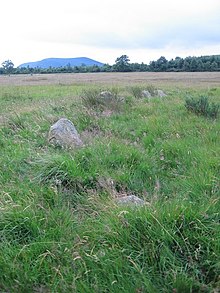
The Hoarstones are one of up to five stone circles known from this area, on the borders between Shropshire and Powys. Of these, only the Hoarstones and Mitchell's Fold survive. Shaped elliptically, the Hoarstones circle measures 23.3 by 21.1m in diameter. It contains between 38 and 40 small stones, identified as dolerites probably sourced locally. There is a central stone inside the circle, although whether this was part of its original prehistoric design is unclear. Several of the stones contain small holes, which according to 19th-century accounts were caused by miners drilling holes into them; gunpowder was then placed into these holes and lit to produce explosions.

The existence of the circle was noted by the antiquarian Reverend C. H. Hartshorne in the 1830s. An excavation took place in 1924, led by Lily F. Chitty.

Location

The term "Hoar Stone" refers to a boundary mark and was recorded as the site's traditional name in the 1920s, [1] with the site having been referred to as the "Hoar Stone Circle", [2] as well as the "Hoarstones". [3] Thinking this name inappropriate, the Reverend C. H. Hartshorne referred to it as Marsh Pool Circle. [1] Other names for the stone circle include Black Marsh and Hemford. [4]

The area on which the circle stands is called Black Marsh. [5] The Hoarstones are located 7 miles north of Bishop's Castle, [3] and 5 ½ miles north of Lydham. [6] It is also one mile northwest of Shelve. [3] The area on which it stands is moorland, at 300 m O.D. [6] The circle is overlooked from the east by the Stiperstones, a quartzite ridge. [3]

Context

While the transition from the Early Neolithic to the Late Neolithic in the fourth and third millennia BCE saw much economic and technological continuity, there was a considerable change in the style of monuments erected, particularly in what is now southern and eastern England. [7] By 3000 BCE, the long barrows, causewayed enclosures, and cursuses which had predominated in the Early Neolithic were no longer built, and had been replaced by circular monuments of various kinds. [7] These include earthen henges, timber circles, and stone circles. [8] Stone circles are found in most areas of Britain where stone is available, with the exception of the island's south-eastern corner. [9] They are most densely concentrated in south-western Britain and on the north-eastern horn of Scotland, near Aberdeen. [9] The tradition of their construction may have lasted for 2,400 years, from 3300 to 900 BCE, with the major phase of building taking place between 3000 and 1,300 BCE. [10]

These stone circles typically show very little evidence of human visitation during the period immediately following their creation. [11] This suggests that they were not sites used for rituals that left archaeologically visible evidence, but may have been deliberately left as "silent and empty monuments". [12] The archaeologist Mike Parker Pearson suggests that in Neolithic Britain, stone was associated with the dead, and wood with the living. [13] Other archaeologists have suggested that the stone might not represent ancestors, but rather other supernatural entities, such as deities. [12]

The Hoarstones are one of two prehistoric stone circles known to survive in Shropshire, the other being Mitchell's Fold. [3] These were among five probable stone circles that are historically recorded as being within two miles of each other, largely in Shropshire but also stretching in neighbouring Powys. [14] Alongside the Hoarstones and Mitchell's Fold, the Whetstones was also a large circle; it was destroyed in 1870. A fourth stone circle, the Druid's Castle, as well as a fifth possible example, at Shelve, were smaller. [14] Given the differences in size, the archaeologist Aubrey Burl suggested that the Druid's Castle was erected at a different time to the larger three rings. [15] Of this group of stone circles, the Hoarstones were the most northerly. [16]

Description

Two of the small holes evident in a stone within the circle, reportedly drilled by miners Shot holes in one of the stones in Hoarstones stone circle - geograph.org.uk - 209196.jpg
Two of the small holes evident in a stone within the circle, reportedly drilled by miners

The ground on which the circle stands is flat, [3] and often boggy. [6] The Hoarstones contains between 38 and 40 stones, [14] arranged in an elliptical fashion. [4] The ring measures between 23.3 by 21.1m in diameter, [3] making it larger than average for the stone circle tradition. [4] Burl noted that it was "irregularly graded" to the southeast. [14] There is a gap between stones on the east side of the monument, which may have been originally intended as an entrance into the ring. [17] Just south of the centre of the circle is a single stone, measuring around 1 metre (3 feet) high; [17] it is unclear if this is an original prehistoric feature of the monument or a later addition. [4] Unlike at some stone circles, there is no clear evidence of a ditch surrounding the stones. [18]

The stones themselves are small. [19] They are a type of local dolerite, which Burl suggested came from the nearby Stapeley Hill. [17] The stones have been inserted into a bed of loam. [18] Some of these stones are buried within the surrounding peat, [6] and they are often concealed amid the grass growing around them. [14] Chitty suggested that some of these stones might have been deliberately shaped and that the larger examples were supported with small pieces of sandstone packing their bases. [16] There are small holes in some of the stones. According to an account recorded in 1893, these were caused during weddings held nearby, when miners drilled holes in the rocks and filled them with gunpowder to produce explosions. [20]

Burl believed that the Hoarstones dated from the Early Bronze Age. [3]

History

Antiquarian and archaeological investigation

The Reverend C. H. Hartshorne visited the site in 1838, publishing the record of this in 1841. [5] Around 1897, a Mr Jarrett ploughed up a perforated sandstone axe-head from the field immediately to the south of the circle, later donated to the Ashmolean Museum in Oxford. [21]

In August 1924, Lily F. Chitty visited the stone circle to measure it for the Stone Monuments Committee of the British Association, noting that at that time the area around it was overgrown with gorse, heather, and marsh grass. On that visit, she was able to identify 33 stones in the circle. [5] She returned in September with her father, the Reverend J. C. M. Chitty, at which point she was able to ascertain the location of three more stones. [5] Assisted by Mr Roberts, the Chittys removed much of the foliage and opened a trench across the northeast part of the circle, revealing a previously concealed stone. This project resulted in the identification of 38 stones. [18] Chitty took chippings of several stones and presented them to Dr H. H. Thomas of the Geological Museum in Jermyn Street, who identified it as being of the dolerite found in Stapeley Hill. [2]

Folklore

In 1881 a widow surnamed Preece, who lived in Rorrington, reported that she knew of the stone circle as the "Fairesses Ring" and that six figures had been reported as having been seen dancing there. [1] Writing in the 1920s, Lily F. Chitty commented that she suspected that this name and its associations had actually been applied to the Mitchell's Fold circle. [1] Chitty also reported a tradition that the ring was called "the Roman Stones," supposing that the name had been transferred from the nearby Roman Gravels, and that "visitors" to the site whom she encountered had reported that the sacrament used to be administered from a hole in the stones. [1]

Related Research Articles

<span class="mw-page-title-main">Ring of Brodgar</span> A neolithic stone circle in Orkney, Scotland

The Ring of Brodgar is a Neolithic henge and stone circle about 6 miles north-east of Stromness on Mainland, the largest island in Orkney, Scotland. It is part of the UNESCO World Heritage Site known as the Heart of Neolithic Orkney.

<span class="mw-page-title-main">The Sanctuary</span> Prehistoric site in Wiltshire, England

The Sanctuary was a stone and timber circle near the village of Avebury in the south-western English county of Wiltshire. Excavation has revealed the location of the 58 stone sockets and 62 post-holes. The ring was part of a tradition of stone circle construction that spread throughout much of Britain, Ireland, and Brittany during the Late Neolithic and Early Bronze Age, over a period between 3300 and 900 BCE. The purpose of such monuments is unknown, although archaeologists speculate that the stones represented supernatural entities for the circle's builders.

<span class="mw-page-title-main">Nine Ladies</span>

The Nine Ladies is a stone circle located on Stanton Moor in Derbyshire in the English East Midlands. The Nine Ladies is part of a tradition of stone circle construction that spread throughout much of Britain, Ireland, and Brittany during the Late Neolithic and Early Bronze Ages, over a period between 3300 and 900 BCE. The purpose of such monuments is unknown, although archaeologists speculate that the stones represented supernatural entities for the circles' builders.

<span class="mw-page-title-main">Doll Tor</span> Bronze age stone circle in Derbyshire

Doll Tor is a stone circle located just to the west of Stanton Moor, near the village of Birchover, Derbyshire in the English East Midlands. Doll Tor is part of a tradition of stone circle construction that spread throughout much of Britain, Ireland, and Brittany during the Late Neolithic and Early Bronze Ages, over a period between 3300 and 900 BCE. The purpose of such monuments is unknown, although archaeologists speculate that the stones represented supernatural entities for the circles' builders.

The Whetstones are, or were, a stone circle beneath Corndon Hill in the parish of Church Stoke, Montgomeryshire, Wales, near the border with Shropshire, England. They lie immediately to the west of the village of White Grit and close to Priestweston. The site is also a short distance from the better-known Hoarstones and Mitchell's Fold circles.

<span class="mw-page-title-main">Stone circles in the British Isles and Brittany</span> Megalithic tradition of monuments

The stone circles in the British Isles and Brittany are a megalithic tradition of monuments consisting of standing stones arranged in rings. These were constructed from 3300 to 900 BCE in Britain, Ireland and Brittany. It has been estimated that around 4,000 of these monuments were originally constructed in this part of north-western Europe during this period. Around 1,300 of them are recorded, the others having been destroyed.

<span class="mw-page-title-main">Nine Stones Close</span> Bronze age stone circle in England

Nine Stones Close, also known as the Grey Ladies, is a stone circle on Harthill Moor in Derbyshire in the English East Midlands. It is part of a tradition of stone circle construction that spread throughout much of Britain, Ireland, and Brittany during the Late Neolithic and Early Bronze Ages, over a period between 3300 and 900 BCE. The purpose of the monument is unknown.

<span class="mw-page-title-main">Nine Stones, Winterbourne Abbas</span> Stone circle in Dorset, southwestern England

The Nine Stones, also known as the Devil's Nine Stones, the Nine Ladies, or Lady Williams and her Dog, is a stone circle located near to the village of Winterbourne Abbas in the southwestern English county of Dorset. Archaeologists believe that it was likely erected during the Bronze Age.

<span class="mw-page-title-main">Kingston Russell Stone Circle</span> Stone circle in Dorset, England

Kingston Russell Stone Circle, also known as the Gorwell Circle, is a stone circle located between the villages of Abbotsbury and Littlebredy in the south-western English county of Dorset. Archaeologists believe that it was likely erected during the Bronze Age. The Kingston Russell ring is part of a tradition of stone circle construction that spread throughout much of Britain, Ireland, and Brittany during the Late Neolithic and Early Bronze Age, over a period between 3,300 and 900 BCE. The purpose of such monuments is unknown, although archaeologists speculate that they were likely religious sites, with the stones perhaps having supernatural associations for those who built the circles.

<span class="mw-page-title-main">Hampton Down Stone Circle</span> Bronze Age construction in Dorset, England

The Hampton Down Stone Circle is a stone circle located near to the village of Portesham in the south-western English county of Dorset. Archaeologists believe that it was likely erected during the Bronze Age. The Hampton Down ring is part of a tradition of stone circle construction that spread throughout much of Britain, Ireland, and Brittany during the Late Neolithic and Early Bronze Age, over a period between 3,300 and 900 BCE. The purpose of such monuments is unknown, although archaeologists speculate that they were likely religious sites, with the stones perhaps having supernatural associations for those who built the circles. However, it has been suggested that the site is not a stone circle at all, but is instead made up of kerbstones from a Bronze Age round barrow.

<span class="mw-page-title-main">Porlock Stone Circle</span> Neolithic stone circle in Somerset, England

Porlock Stone Circle is a stone circle located on Exmoor, near the village of Porlock in the south-western English county of Somerset. The Porlock ring is part of a tradition of stone circle construction that spread throughout much of Britain, Ireland, and Brittany during the Late Neolithic and Early Bronze Age, over a period between 3300 and 900 BCE. The purpose of such monuments is unknown, although archaeologists speculate that the stones represented supernatural entities for the circles' builders.

<span class="mw-page-title-main">Withypool Stone Circle</span> Late neolithic stone circle in Somerset, England

Withypool Stone Circle, also known as Withypool Hill Stone Circle, is a stone circle located on the Exmoor moorland, near the village of Withypool in the southwestern English county of Somerset. The ring is part of a tradition of stone circle construction that spread throughout much of Britain, Ireland, and Brittany during the Late Neolithic and Early Bronze Age, over a period between 3300 and 900 BCE. The purpose of such monuments is unknown, although archaeologists speculate that the stones represented supernatural entities for the circle's builders.

<span class="mw-page-title-main">Falkner's Circle</span> Neolithic stone circle in Wiltshire, England

Falkner's Circle was a stone circle near the village of Avebury in the south-western English county of Wiltshire. Built from twelve sarsen megaliths, it measured about 37 metres (121 ft) in diameter, although only one of these stones remains standing. The ring was part of a tradition of stone circle construction that spread throughout much of Britain, Ireland, and Brittany during the Late Neolithic and Early Bronze Age, over a period between 3300 and 900 BCE. The purpose of such monuments is unknown, although archaeologists speculate that the stones represented supernatural entities for the circle's builders.

<span class="mw-page-title-main">Fir Clump Stone Circle</span> Neolithic stone circle in Wiltshire, England

Fir Clump Stone Circle was a stone circle in Burderop Wood near Wroughton, Wiltshire, in South West England. The ring was part of a tradition of stone circle construction that spread throughout much of Britain, Ireland, and Brittany during the Late Neolithic and Early Bronze Age, over a period between 3300 and 900 BCE. The purpose of such monuments is unknown, although some archaeologists speculate that the stones represented supernatural entities for the circle's builders.

Winterbourne Bassett Stone Circle is the remains of a stone circle near the village of Winterbourne Bassett in Wiltshire, South West England. Investigations in the 18th and 19th centuries found evidence of an outer and inner ring, and a single central stone; today six stones are visible although none remain upright.

Clatford Stone Circle, also known as The Broadstones, was a stone circle located in the village of Clatford in the south-western English county of Wiltshire.

Tisbury Stone Circle and Henge was a stone circle and henge in the south-western English county of Wiltshire. Archaeologists believe that it was likely erected during the Bronze Age.

<span class="mw-page-title-main">Day House Lane Stone Circle</span> Neolithic stone circle in Wiltshire, England

Day House Lane Stone Circle, also known as Coate Stone Circle, is a stone circle near the hamlet of Coate, now on the southeastern edge of Swindon, in the English county of Wiltshire. The ring was part of a tradition of stone circle construction that spread throughout much of Britain, Ireland, and Brittany during the Late Neolithic and Early Bronze Age, over a period between 3300 and 900 BCE. The purpose of such monuments is unknown, although some archaeologists speculate that the stones represented supernatural entities for the circle's builders.

Broome Stone Circle was a stone circle located in the south-western English county of Wiltshire. The ring was part of a tradition of stone circle construction that spread throughout much of Britain, Ireland, and Brittany during the Late Neolithic and Early Bronze Age, over a period between 3300 and 900 BCE. The purpose of such monuments is unknown, although archaeologists speculate that the stones represented supernatural entities for the circle's builders.

Hodson Stone Circle was a stone circle in the village of Hodson in the south-western English county of Wiltshire. The ring was part of a tradition of stone circle construction that spread throughout much of Britain, Ireland, and Brittany during the Late Neolithic and Early Bronze Age, over a period between 3300 and 900 BCE. The purpose of such monuments is unknown, although some archaeologists speculate that the stones represented supernatural entities for the circle's builders.

References

Footnotes

  1. 1 2 3 4 5 Chitty 1926, p. 252.
  2. 1 2 Chitty 1926, p. 249.
  3. 1 2 3 4 5 6 7 8 Burl 2005, p. 74.
  4. 1 2 3 4 Burl 2000, p. 95; Burl 2005, p. 74.
  5. 1 2 3 4 Chitty 1926, p. 247.
  6. 1 2 3 4 Thom, Thom & Burl 1980, p. 27.
  7. 1 2 Hutton 2013, p. 81.
  8. Hutton 2013, pp. 91–94.
  9. 1 2 Hutton 2013, p. 94.
  10. Burl 2000, p. 13.
  11. Hutton 2013, p. 97.
  12. 1 2 Hutton 2013, p. 98.
  13. Hutton 2013, pp. 97–98.
  14. 1 2 3 4 5 Burl 2000, p. 95.
  15. Burl 2000, p. 101.
  16. 1 2 Chitty 1926, p. 250; Thom, Thom & Burl 1980, p. 27.
  17. 1 2 3 Thom, Thom & Burl 1980, p. 27; Burl 2005, p. 74.
  18. 1 2 3 Chitty 1926, p. 248.
  19. Chitty 1926, p. 247; Thom, Thom & Burl 1980, p. 27; Burl 2005, p. 74.
  20. Lewis 1893, p. 81; Chitty 1926, p. 250; Burl 2005, p. 74.
  21. Chitty 1926, pp. 252–253.

Bibliography

  • Burl, Aubrey (2000). The Stone Circles of Britain, Ireland and Brittany . New Haven and London: Yale University Press. ISBN   978-0-300-08347-7.
  • Burl, Aubrey (2005). A Guide to the Stone Circles of Britain, Ireland and Brittany. New Haven and London: Yale University Press. ISBN   978-0-300-11406-5.
  • Chitty, Lily F. (1926). "The Hoar Stone or Marsh Pool Circle" (PDF). Transactions of the Shropshire Archaeological Society and Natural History. 10: 247–53.
  • Hutton, Ronald (2013). Pagan Britain. New Haven and London: Yale University Press. ISBN   978-0-300-19771-6.
  • Lewis, A. L. (1893). "On the Connection between Stone Circles and Adjacent Hills" (PDF). Transactions of the Shropshire Archaeological Society and Natural History. 5 (1): 78–86.
  • Thom, Alexander; Thom, Archibald Stevenson; Burl, Aubrey (1980). Megalithic Rings: Plans and Data for 229 Monuments in Britain. BAR British Series 81. Oxford: British Archaeological Reports. ISBN   0-86054-094-4.

Further reading