Leaze stone circle

Last updated
Leaze stone circle
Cornwall UK location map.svg
Archaeological site icon (red).svg
Shown within Cornwall
Location Bodmin Moor, Cornwall
Coordinates 50°33′56″N4°37′57″W / 50.565529°N 4.63246°W / 50.565529; -4.63246 Coordinates: 50°33′56″N4°37′57″W / 50.565529°N 4.63246°W / 50.565529; -4.63246
Type Stone circle
History
Periods Bronze Age

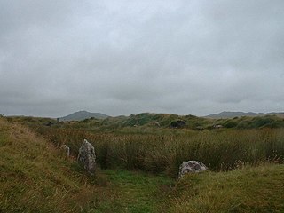
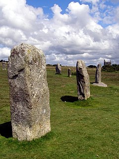
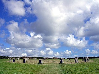
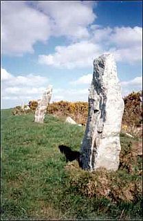
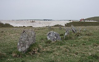
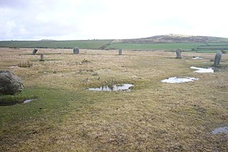
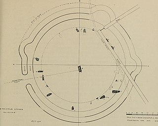
Leaze stone circle is a stone circle located in the parish of St. Breward on Bodmin Moor in Cornwall, UK (grid reference SX13667728 ).

Stone circle monument of standing stones arranged in a circle

A stone circle is a circular alignment of standing stones. They are commonly found across Northern Europe and Great Britain and typically date from the Late Neolithic and Early Bronze Age eras, with most concentrations appearing from 3000 BC. The best known examples include those at the henge monument at Avebury, the Rollright Stones and elements within the ring of standing stones at Stonehenge. Ancient stone circles appear throughout Europe with many appearing in the Pyrenees, on the Causse de Blandas in southern France in the Cevennes, in the Alps, and Bulgaria.

Bodmin Moor granite moorland in northeastern Cornwall, England

Bodmin Moor is a granite moorland in northeastern Cornwall, England. It is 208 square kilometres (80 sq mi) in size, and dates from the Carboniferous period of geological history. It includes Brown Willy, the highest point in Cornwall, and Rough Tor, a slightly lower peak. Many of Cornwall's rivers have their sources here. It has been inhabited since at least the Neolithic era, when primitive farmers started clearing trees and farming the land. They left their megalithic monuments, hut circles and cairns, and the Bronze Age culture that followed left further cairns, and more stone circles and stone rows. By medieval and modern times, nearly all the forest was gone and livestock rearing predominated.

Cornwall County of England

Cornwall is a county in South West England in the United Kingdom. The county is bordered to the north and west by the Celtic Sea, to the south by the English Channel, and to the east by the county of Devon, over the River Tamar which forms most of the border between them. Cornwall forms the westernmost part of the South West Peninsula of the island of Great Britain. The furthest southwestern point of Great Britain is Land's End; the southernmost point is Lizard Point. Cornwall has a population of 563,600 and covers an area of 3,563 km2 (1,376 sq mi). The county has been administered since 2009 by the unitary authority, Cornwall Council. The ceremonial county of Cornwall also includes the Isles of Scilly, which are administered separately. The administrative centre of Cornwall, and its only city, is Truro.

Contents

Description

The circle stands in enclosed pasture near the buildings of Leaze farm and is composed of sixteen stones, six of which have fallen. It is approximately twenty four metres in diameter and is cut through the centre by a hedge. [1] It has been estimated the circle once comprised twenty two stones. There is one stone positioned outside of the circle along with three dips suggested to have been formed by removed stones. [1] The stones are of squarish granite of approximately 1.22 metres (4.0 ft) in height and around .50 metres (1.6 ft) wide. Rough Tor, Tolborough Tor and Catshole Tor can be seen from the site with Brown Willy obscured behind Garrow Tor.

Rough Tor mountain in the United Kingdom

Rough Tor, or Roughtor, is a tor on Bodmin Moor, Cornwall, United Kingdom. The site is composed of the tor summit and logan stone, a neolithic tor enclosure, a large number of Bronze Age hut circles, and some contemporary monuments.

Brown Willy Hill in Cornwall, England

Brown Willy is a hill in Cornwall, England, United Kingdom. The summit, at 1,378 feet (420 m) above sea level, is the highest point of Bodmin Moor and of Cornwall as a whole. It is situated about 2.5 miles (4.0 km) north-west of Bolventor and 4 miles (6.4 km) south-east of Camelford. The hill has a variable appearance that depends on the vantage point from which it is seen. It bears the conical appearance of a sugarloaf from the north but widens into a long multi-peaked crest from closer range.

Garrow Tor

Garrow Tor is a bare, tor-crowned hill, 330 metres (1,080 ft) high, located on Garrow Downs in the northwest of Bodmin Moor in the county of Cornwall, England, UK.

The fragmentary remains of two other stone circles (Emblance Downs stone circles) can be found about 300 metres northwest of Leaze stone circle. [2] Less than 1 kilometre in a west by north-west direction lies the enigmatic enclosure known as King Arthur's Hall. [3]

Emblance Downs stone circles

Emblance Downs stone circles are a pair of stone circles located in the parish of St. Breward on Bodmin Moor in Cornwall, UK.

King Arthurs Hall

King Arthur's Hall is a megalithic enclosure on Bodmin Moor in Cornwall, England. It is thought to be a late Neolithic or early Bronze Age ceremonial site.

Alignments

Alexander Thom proposed a definitely indicated, site to stone, solar alignment at the site. [4]

Alexander Thom Scottish engineer

Alexander "Sandy" Thom was a Scottish engineer most famous for his theory of the Megalithic yard, categorisation of stone circles and his studies of Stonehenge and other archaeological sites.

Sun Star at the centre of the Solar System

The Sun is the star at the center of the Solar System. It is a nearly perfect sphere of hot plasma, with internal convective motion that generates a magnetic field via a dynamo process. It is by far the most important source of energy for life on Earth. Its diameter is about 1.39 million kilometers, or 109 times that of Earth, and its mass is about 330,000 times that of Earth. It accounts for about 99.86% of the total mass of the Solar System. Roughly three quarters of the Sun's mass consists of hydrogen (~73%); the rest is mostly helium (~25%), with much smaller quantities of heavier elements, including oxygen, carbon, neon, and iron.

Related Research Articles

The Hurlers (stone circles)

The Hurlers is a group of three stone circles in the civil parish of St Cleer, Cornwall, England, UK. The site is half-a-mile (0.8 km) west of the village of Minions on the eastern flank of Bodmin Moor, and approximately four miles (6 km) north of Liskeard at grid reference SX 258 714.

The Merry Maidens

The Merry Maidens, also known as Dawn's Men is a late neolithic stone circle located 2 miles (3 km) to the south of the village of St Buryan, in Cornwall, United Kingdom. A pair of standing stones, The Pipers is associated both geographically and in legend.

Rudston Monolith menhir

The Rudston Monolith at over 7.6 metres (25 ft) is the tallest megalith in the United Kingdom. It is situated in the churchyard in the village of Rudston in the East Riding of Yorkshire.

Tregeseal East stone circle

Tregeseal East is a heavily restored prehistoric stone circle around one mile northeast of the town of St Just in Cornwall, England, United Kingdom. The nineteen granite stones are also known as The Dancing Stones. It is the one surviving circle of definite pair, that once stood aligned along an near east–west axis on the hillside to the south of Carn Kenidjack.

Boskednan stone circle stone circle

Boskednan stone circle is a partially restored prehistoric stone circle near Boskednan, around 4 miles northwest of the town of Penzance in Cornwall, United Kingdom. The megalithic monument is traditionally known as the Nine Maidens or Nine Stones of Boskednan, although the original structure may have contained as many as 22 upright stones around its 69-metre perimeter.

Nine Maidens stone row stone row

Nine Maidens stone row is an ancient monument in the parish of St Columb Major, Cornwall, England. The Nine Maidens are also known in Cornish as Naw-voz, or Naw-whoors meaning "The nine sisters". This late neolithic stone row is 2 miles (3.2 km) north of St Columb Major.

Cheetham Close

Cheetham Close is a megalithic site and scheduled ancient monument located in Lancashire, very close to the boundary with Greater Manchester, England. The megalith was in good condition until a farmer from Turton sledgehammered the circle in the 1870s. According to an article published in 1829, Cheetham Close was once a druidical ritual place and a Roman road passed 'within two hundred yards' of the megalith.

Balquhain

Balquhain, also known as Balquhain Stone Circle, The Chapel of Garioch or Inveramsay, is a recumbent stone circle 3 miles (4.8 km) from Inverurie in Scotland. It is a scheduled ancient monument.

Stannon stone circle

Stannon stone circle is a stone circle located near St. Breward on Bodmin Moor in Cornwall, England.

The Pipers standing stones in Bodmin Moor, UK

The Pipers are a pair of standing stones near The Hurlers stone circles, located on Bodmin Moor near the village of Minions, Cornwall, UK. They share the name with another pair of standing stones near the Merry Maidens to the south of the village of St Buryan, also in Cornwall.

Duloe stone circle

Duloe stone circle or Duloe circle is a stone circle near the village of Duloe, located 5 miles (8.0 km) from Looe in southeast Cornwall, England, UK.

Fernacre

Fernacre, also known as Fernacre stone circle or Fernacre circle, is a stone circle located on the slopes of the De Lank River, 1.25 miles (2.01 km) northeast of St Breward on Bodmin Moor in Cornwall in the United Kingdom.

Goodaver stone circle

Goodaver, Goodaver stone circle or Goodaver circle is a stone circle located in the parish of Altarnun, near Bolventor on Bodmin Moor in Cornwall, UK.

Trippet stones

The Trippet stones or Trippet stones circle is a stone circle located on Manor Common in Blisland, 9 kilometres (5.6 mi) north northeast of Bodmin on Bodmin Moor in Cornwall, UK. The Stripple stones are nearby.

Stripple stones Neolithic henge monument; stone circle

The Stripple stones is a henge and stone circle located on the south slope of Hawk's Tor, Blisland, 10 kilometres (6.2 mi) north northeast of Bodmin on Bodmin Moor in Cornwall, England, UK.

Nine Stones, Altarnun Bronze Age stone circle near Altarnun, Cornwall, England, United Kingdom

The Nine Stones is a stone circle located 3 kilometres (1.9 mi) south southeast of Altarnun, 11 kilometres (6.8 mi) west of Launceston on Bodmin Moor in Cornwall, UK.

Tor cairn prehistoric archaeological site

A tor cairn is a prehistoric cult site occurring in the British Isles, especially in Cornwall and Devon but also in Wales. It consists of a circular enclosure of stones or a platform of loose rocks surrounding a natural tor, sometimes encircled by a ditch. The diameter of the roughly 35 tor cairns ranges from 12 to over 30 metres and their height varies from 0.5 to 4.0 metres. There is usually an entrance to the enclosed area and pits in the ground between the rock outcrop (tor) itself and the enclosure.

References

  1. 1 2 Historic England. "Leaze stone circle (433138)". PastScape. Retrieved 7 November 2013.
  2. Historic England. "Emblance Downs (4433225)". PastScape. Retrieved 7 November 2013.
  3. Historic England. "King Arthurs Hall (433143)". PastScape. Retrieved 7 November 2013.
  4. Alexander Thom (1 August 1967). Megalithic Sites in Britain, p. 100. Oxford Univ Pr on Demand. ISBN   978-0-19-813148-9 . Retrieved 20 July 2011.