Brown Willy

Last updated

Brown Willy
Bronn Wennili
Brown Willy.jpg
Brown Willy from the summit of Rough Tor
Highest point
Elevation 420 m (1,380 ft) [1]
Prominence 314 m (1,030 ft)
Parent peak High Willhays
Listing Marilyn, County Top
Coordinates 50°35′20″N4°36′08″W / 50.588832°N 4.602179°W / 50.588832; -4.602179
Geography
Cornwall UK mainland relief location map.jpg
Red triangle with thick white border.svg
Brown Willy
Brown Willy shown within Cornwall
England relief location map.jpg
Red triangle with thick white border.svg
Brown Willy
Brown Willy (England)
Location Bodmin Moor, Cornwall, England, UK
OS grid SX158799
Topo map OS Landranger 201

Brown Willy (possibly from Cornish Bronn Wennili meaning "hill of swallows" [2] or from Cornish Bronn Ewhella meaning "highest hill") is a hill in Cornwall, England, United Kingdom. The summit, at 1,378 feet (420 metres) above sea level, is the highest point of Bodmin Moor and of Cornwall as a whole. [1] It is about 2+12 miles (4 kilometres) northwest of Bolventor and 4 miles (6 kilometres) southeast of Camelford. The hill has a variable appearance that depends on the vantage point from which it is seen. It bears the conical appearance of a sugarloaf from the north but widens into a long multi-peaked crest from closer range. [3]

Contents

Toponymy

The first part of the hill's name is a common Brythonic element meaning "breast, pap; hill-side, slope, breast (of hill)", which is frequent in Welsh placenames. [4] The Cornish historian and language expert Henry Jenner suggested that the name came from a corruption of the Cornish words bronn ughella/ewhella meaning "highest hill", [5] as it is the highest point of Bodmin Moor and of Cornwall. The highest hill in Devon has the similar name, High Willhays which falls in line with this theory. More recently, toponymist Craig Weatherhill has put forward the alternative suggestion that it could be from 'Bronn Wennili' which translates as 'Hill of Swallows'. The name has evolved through a variety of historical spellings as follows: Brunwenely c.1200, 1239; Brown Wenely 1239; Brenwenelyn 1276; Bronwenely, Brunwely 1280; Brounwenely 1350, 1362; Broun Welyn 1386; Brounwenyly 1401; Brownwenelegh 1450, 1470; Brounwellye, Bronwelly 1576; Brown-wellye 1584; Brounwellie 1639; Menar Brownuello 1754. [6]

It has frequently been noted on lists of unusual place names. [7] In 2012 a campaign was launched to have the hill's name restored to the original Bronn Wennili on the grounds that it would be "slightly more attractive to residents and tourists than Brown Willy". Cornish residents objected to the idea. One commented: "It's been Brown Willy for as far back as living memory goes and I suspect, as others have pointed out, that it will always be called that, whatever name we may formally give it." [8] The Daily Telegraph ran an editorial supporting the existing name and called for campaigners to keep their "hands off Brown Willy". [9]

Geography and geology

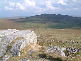
The summit of Brown Willy is 1,378 feet (420 metres) above sea level, the highest point on Bodmin Moor and in the county of Cornwall. [8] [10] [11] The geography of the surrounding terrain is typical of Bodmin Moor – tors surrounded by desolate moorland. [12] Streams and marshes are common surrounding the summit, and the River Fowey rises nearby. There are naturally occurring piles of granite boulders around the summit, and one, known as the Cheesewring is composed of five separate rocks which get progressively higher towards the top. [10]

The hill is part of a 1,221-acre (494-hectare) estate known as Fernacre and includes a five-bedroom farm house. The property was put on the market in September 2016 for £2.8 million and sold to an undisclosed buyer the following April. The new owner has the grazing rights for the property and shooting rights for deer, snipe and woodcock. Under the Countryside and Rights of Way Act 2000, the public will continue to have the right to walk on the hill. [13] [14]

Brown Willy Cairns

Brown Willy Summit (North) Cairn with Ordnance Survey triangulation station Trig point and summit cairn, Brown Willy - geograph.org.uk - 1005985.jpg
Brown Willy Summit (North) Cairn with Ordnance Survey triangulation station

There are two man-made cairns on the summit. [15] Brown Willy Summit Cairn or Brown Willy North Cairn is a man made rock pile that sits alongside an Ordnance Survey triangulation station. [16]

The Cornish word for "cairn" is karn (from karnow, meaning "rock piles"), and it has been suggested that Cornwall's ancient name Kernow is related. [17] [18] William Copeland Borlase classified ridge-top cairns such as these in the most common category a "bowl"- or "cone"-shaped tumulus. He also referred to them as "sepulchral mounds" but admitted that burials had not been found at many. [19] Brown Willy Summit Cairn has never been excavated and folklore suggests an ancient Cornish king may lie entombed underneath. [16] Nicholas Johnson and Peter Rose dated nine of the cairns on Bodmin Moor, eight have mean dates which range between 2162 and 1746 cal BC, suggesting the early Bronze Age was the main building period for cairns of this type. [20] These are amongst the most intact due to their remote and inaccessible location. Many rocks from similar cairns have been spoiled and removed over centuries of neglect to be re-used in dry stone walling and other local construction. [21]

Rodney Castleden has suggested that from the centre of Stannon stone circle, the autumn equinox sun rises over Brown Willy North Cairn. [22] and Christopher Tilley refers to a "dramatic association with Rough Tor. [23] These purported alignments have been taken as evidence of some astronomical purpose in cairn placement and construction.

Recreation

Here, in his deafness and his loneliness,
My father's sad grey eyes in gathering dusk
Saw Roughtor and Brown Willy hide the view
Of that bold coast-line where he was not born—

John Betjeman, Summoned by Bells (1960) [24]

Brown Willy is a popular destination for walkers and is said to be one of "the UK's best-loved high points". [12] The hill features in an annual race held on New Year's Day that starts and finishes at Jamaica Inn, an old coaching inn made famous by Daphne du Maurier's 1936 novel of the same name. [12] [25]

Brown Willy and Rough Tor are listed in a Ward Lock travel guide from the 1920s as places to visit, saying that 'The scenery is wildly grand, rugged and bleak' and recommending hiring a vehicle from Camelford for the visit. [26]

The hill is regarded as a sacred mountain by members of the Aetherius Society, a UFO religion founded in 1954 by George King. They believe that Brown Willy was charged with "holy energy" on 23 November, which they celebrate each year as "Charging Day", and gather at the hill on that day each year to celebrate the sun's alignment with "positive and negative rocks". [27] Other Aetherian "holy mountains" include Mount Kilimanjaro in Tanzania, a mountain in California, two in New South Wales in Australia and two in Devon. [27]

Environment

The hill is known for a meteorological phenomenon known as the Brown Willy effect, in which heavy rainfall develops over high ground and then travels downwind for a long distance. The effect produces heavy localised rain which can cause disastrous flash flooding such as the Boscastle flood of 2004. In another case when the effect was manifested, a continuous line of showers developed on 27 March 2006 stretching 145 miles from Brown Willy to Oxfordshire. [28]

Brown Willy is unusual in that, unlike other hills on Bodmin Moor, there is little evidence of prehistoric settlement around it. It may have instead been set aside for use as a communal area for people from the surrounding settlements, who may have used the ridge as a ceremonial procession route. [29] There are no house circles or platforms in the area of the summit. The remains of seventeen houses and platforms have been found on the lower part of the eastern slopes and another 23 low on the western slopes; they were crudely constructed and probably only used seasonally. [30] Nearly two-thirds of them were constructed in positions with a clear line of sight to the summit of Brown Willy and the nearby hill of Rough Tor, suggesting that the hilltops were viewed as special places. [31]

Media

It is the location for a comedy film of the same name, about two 40-year-old former school-friends on a misguided stag do, written and directed by Brett Harvey. [32]

Related Research Articles

<span class="mw-page-title-main">Bodmin Moor</span> Granite moorland in northeast Cornwall, England

<span class="mw-page-title-main">Cairn</span> Human-made pile of stones or burial monument

A cairn is a man-made pile of stones raised for a purpose, usually as a marker or as a burial mound. The word cairn comes from the Scottish Gaelic: càrn[ˈkʰaːrˠn̪ˠ].

<span class="mw-page-title-main">Tor enclosure</span> Type of prehistoric monument found in southwestern Great Britain

A tor enclosure is a prehistoric monument found in the southwestern part of Great Britain. These monuments emerged around 4000 BCE in the early Neolithic.

<span class="mw-page-title-main">High Willhays</span>

High Willhays, or according to some authorities High Willes, is the highest point on Dartmoor, Devon, at 621 metres above sea level, and the highest point in Southern England.

<span class="mw-page-title-main">St Breward</span> Civil parish and village in Cornwall, England

St Breward is a civil parish and village in Cornwall, England, United Kingdom. It is on the western side of Bodmin Moor, about 6 miles (10 km) north of Bodmin. At the 2011 census the parish population including Cooksland and Fentonadle was 919.

<span class="mw-page-title-main">Rough Tor</span> Tor on Bodmin Moor, Cornwall, England

<span class="mw-page-title-main">De Lank River</span> River in north Cornwall, England

The De Lank River is a small river in north Cornwall, England. It is a tributary of the River Camel and is approximately nine miles (14.5 km) long from its source on Bodmin Moor to its confluence with the Camel two miles (3 km) south of St Breward.

<span class="mw-page-title-main">Craddock Moor stone circle</span> Stone circle on Bodmin Moor, Cornwall, England

Craddock Moor Stone Circle or Craddock Moor Circle is a stone circle located near Minions on Bodmin Moor in Cornwall, UK. It is situated around half a mile Northwest of The Hurlers.

<span class="mw-page-title-main">Brown Gelly</span> Hill, tor and ridge on Bodmin Moor, Cornwall, England

Brown Gelly is a tor, hill and ridge near Dozmary Pool on Bodmin Moor near Liskeard in Cornwall, UK.

<span class="mw-page-title-main">Stannon stone circle</span> Stone circle on Bodmin Moor, Cornwall, England

Stannon stone circle is a stone circle located near St. Breward on Bodmin Moor in Cornwall, England.

<span class="mw-page-title-main">Fernacre</span> Stone circle on Bodmin Moor, Cornwall, England

Fernacre, also known as Fernacre stone circle or Fernacre circle, is a stone circle located on the slopes of the De Lank River, 1.25 miles (2.01 km) northeast of St Breward on Bodmin Moor in Cornwall in the United Kingdom.

<span class="mw-page-title-main">Showery Tor</span> Tor on Bodmin Moor, Cornwall, England

Showery Tor is a rocky outcrop on a ridge-top approximately 0.6 kilometres (0.37 mi) north of the Rough Tor summit, near Camelford on Bodmin Moor in Cornwall. It is notable for its rock formations and prehistoric monuments.

Goodaver, Goodaver stone circle or Goodaver circle is a stone circle located in the parish of Altarnun, near Bolventor on Bodmin Moor in Cornwall.

<span class="mw-page-title-main">Trippet stones</span> Stone circle on Bodmin Moor, Cornwall, England

The Trippet stones or Trippet stones circle is a stone circle located on Manor Common in Blisland, 9 kilometres (5.6 mi) north northeast of Bodmin on Bodmin Moor in Cornwall, UK. The Stripple stones are nearby.

<span class="mw-page-title-main">Sharptor</span> Human settlement in England

Sharptor is a hamlet west of Henwood in the civil parish of Linkinhorne in east Cornwall, England, United Kingdom. It is named after Sharp Tor on Bodmin Moor. Sharptor is close to Minions to the south, Kingbeare in the north and Darleyford to the east. Sharptor is around 280 metres (920 ft) above sea level.

<span class="mw-page-title-main">Alex Tor</span> Stone circles on Bodmin Moor, Cornwall, England

Alex Tor is a conical hill, 291 metres (955 ft) high, located in the west of Bodmin Moor in the county of Cornwall, England.

<span class="mw-page-title-main">Kilmar Tor</span> Tor on Bodmin Moor, Cornwall, England

Kilmar Tor is an elongated hill, 396 metres (1,299 ft) high and running from SW to NE, on Bodmin Moor in the county of Cornwall, England. Its prominence of 118 metres qualifies it as a HuMP.

Leskernick Hill is on Bodmin Moor in Cornwall, UK. It is 329m high and has grid reference SX183803. Leskernick Hill is within the Cornwall AONB as part of Area 12: Bodmin Moor in the parish of Altarnun. It lies in an area of moorland that is common land. Its parent hill is Brown Willy and it is within sight of Rough Tor and other local tors

<span class="mw-page-title-main">Cornish Bronze Age</span> Period of Cornish history from c. 2400 until c. 800 BCE

The Cornish Bronze Age is an era of the history of Cornwall that spanned the period from c. 2400 BCE to c. 800 BCE. It was preceded by the Cornish Neolithic, and followed by the Cornish Iron Age. It is characterized by the introduction and widespread use of copper and copper-alloy (bronze) weapons and tools.

References

  1. 1 2 Bathurst, David (2012). Walking the county high points of England. Chichester: Summersdale. pp. 161–166. ISBN   978-1-84-953239-6.
  2. Steven Morris (13 September 2016). "Brown Willy: Cornwall's highest point up for sale at £2.8m". The Guardian . Retrieved 28 September 2020.
  3. Humphreys, Rob (2008). The Rough Guide to Britain . Rough Guides. p.  360. ISBN   978-1-85828-549-8.
  4. Coates, Richard; Breeze, Andrew (2000). Celtic voices, English places: studies of the Celtic impact on place-names in England. Shaun Tyas. ISBN   978-1-900289-41-2.
  5. Jenner, Henry (1912). History in Cornish place-names. Oxford University. p. 12. Retrieved 25 February 2019.
  6. Padel, Oliver James (1988). A popular dictionary of Cornish place-names. A. Hodge. p. 60. ISBN   978-0-906720-15-8.
  7. Parker, Quentin (2010). Welcome to Horneytown, North Carolina, Population: 15: An insider's guide to 201 of the world's weirdest and wildest places. Adams Media. pp. viii. ISBN   9781440507397.
  8. 1 2 "Campaign to change Brown Willy's name". BBC News. 5 November 2012.
  9. "Hands off Brown Willy". The Daily Telegraph. 5 November 2012.
  10. 1 2 Charles Knight (1866). The English Cyclopaedia: Geography. Bradbury, Evans. p. 588. Retrieved 4 January 2013.
  11. Charlotte Maria S. Mason (1881). The Forty Shires: Their History, Scenery, Arts, and Legends, p. 297 . Retrieved 17 March 2011.
  12. 1 2 3 Muir, Jonny (2011). "Brown Willy". The UK's County Tops: Reaching the top of 91 historic counties (First ed.). Milnthorpe: Cicerone. pp. 20–21. ISBN   978-1-85284-629-9.
  13. "Brown Willy is sold". The Cornishman. 27 April 2017. p. 26.
  14. OS Explorer Bodmin Moor (Map). Southampton: Ordnance Survey. 2015. ISBN   978 0 319 24311 4.
  15. Prehistoric Society (London; England) (2006). Proceedings of the Prehistoric Society, p. 343. Prehistoric Society. Retrieved 18 March 2011.
  16. 1 2 Sabine Baring-Gould (1923). A Book of Cornwall. Methuen & Co. Ltd. Retrieved 17 March 2011.
  17. Gerva Kynsa dhe Dressa Gradh – Quick Reference Online Cornish Dictionary
  18. R. Morton Nance (July 1990) [1934]. An English-Cornish and Cornish-English Dictionary. Originally printed for the Federation of Old Cornwall Societies by J. Lanham. ISBN   978-1-85022-055-8.
  19. William Copeland Borlase (April 1994) [1872]. Nænia Cornubiæ, a descriptive essay, illustrative of the sepulchres and funereal customs of the early inhabitants of the County of Cornwall. Longmans, Green, Reader, and Dyer, London. ISBN   978-1-897853-36-8.
  20. Nicholas Johnson; Peter Rose; Desmond Bonney (July 1994). Bodmin Moor: an archaeological survey. The human landscape to c.1800, p. 40. English Heritage. ISBN   978-1-85074-381-1 . Retrieved 22 May 2011.
  21. Karin Altenberg (October 2003). Experiencing Landscapes: A Study of Space and Identity in Three Marginal Areas of Medieval Britain and Sweden, p. 109. Almqvist & Wiksell. ISBN   978-91-22-01997-8 . Retrieved 17 March 2011.
  22. Rodney Castleden (1992). Neolithic Britain: New Stone Age Sites of England, Scotland, and Wales. Routledge. pp. 48–. ISBN   978-0-415-05845-2 . Retrieved 17 March 2011.
  23. Christopher Tilley (15 July 2010). Interpreting Landscapes: geologies, topographies, identities;. Explorations in Landscape Phenomenology 3. Left Coast Press. pp. 389–. ISBN   978-1-59874-374-6 . Retrieved 3 May 2011.
  24. Betjeman, John (1960). "Chapter VIII: Cornwall in Adolescence". Summoned by Bells . John Murray. p. 79.
  25. Du Maurier, Daphne (1936). Jamaica Inn. New York: HarperCollins. p. 49. ISBN   9780062404893.
  26. A pictorial and descriptive guide to Newquay and North Cornwall. Red guides (9th (revised) ed.). London: Ward, Lock & Co. 1927. p. 71.
  27. 1 2 "Society visits its holy mountain of Brown Willy on pilgrimage". Cornish Guardian. 7 December 2011. Archived from the original on 3 December 2013. Retrieved 4 January 2012.
  28. "Floods". UKTV. Retrieved 4 January 2012.
  29. Bender, Barbara; Hamilton, Sue; Tilley, Christopher (2008). Stone Worlds: Narrative and Reflexivity in Landscape Archaeology. Left Coast Press. p. 231. ISBN   978-1-59874-219-0.
  30. Bender, Hamilton & Tilley (2008), p. 388
  31. Bender, Hamilton & Tilley (2008), p. 440
  32. Brown Willy is Cornwall’s answer to Withnail & I: Brown Willy is Cornwall’s answer to Withnail & I, accessdate: May 2, 2016